Category Archives: Israel

Capernaum follow up – from the air

The first photo today shows that Caperanum is located on the [north] shore of the Sea of Galilee. The enclosed area belongs to the Franciscan Fathers who bought the property already thought to be Capernaum in 1894. The site was fenced to prevent removal of the materials.

In our photo you see the property as it has been edited by various archaeological digs. Two structures stand out among the ruins – the synagogue and the new memorial church we wrote about in the previous post. Click on the photo for a larger image suitable for use in teaching.

Capernaum from the air. Photo: ferrelljenkins.blog.

Viewing Capernaum from the air. Photo by Ferrell Jenkins.

With our view to the north, the property on the right of the Franciscan property belongs to the Greek Orthodox Church. You will see their little red-domed church near the middle of our image. The property between that church and the Franciscan property was excavated after 1978 under the direction of Vassilios Tzaferis but is not open to the public.

Further east a dock extending into the water provides a place for boats to dock and allow passengers to meet their bus to continue touring.

Capernaum from the air. Fransciscian property on left (west) and the Orthodox property on the right (east). Photo: ferrelljenkins.blog.

Capernaum from the air. Fransciscian property on left (west) and the Orthodox property on the right (east). Photo by Ferrell Jenkins.

Much of the earthly ministry of Jesus was conducted in this little plot of land. Imagine such a small beginning here and in the surrounding towns. By the early 60s of the first century the preaching that Jesus is the Christ had reached the capital of the Roman empire (Acts 28).

Ferrell’s Favorite Foto #37 – Now and Then at Capernaum

In 2015 we posted here about some changes that we noticed when we visited Capernaum on the north shore of the Sea of Galilee. These changes were more like refurbishing the site to make it easier and more pleasant to visit.

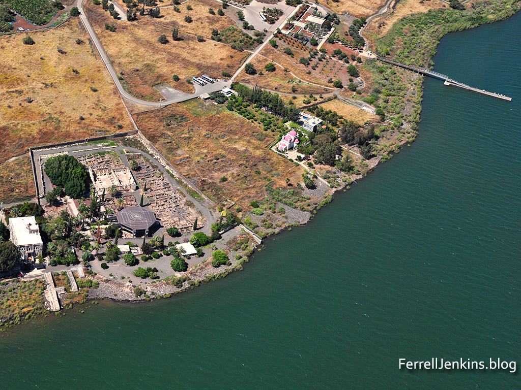
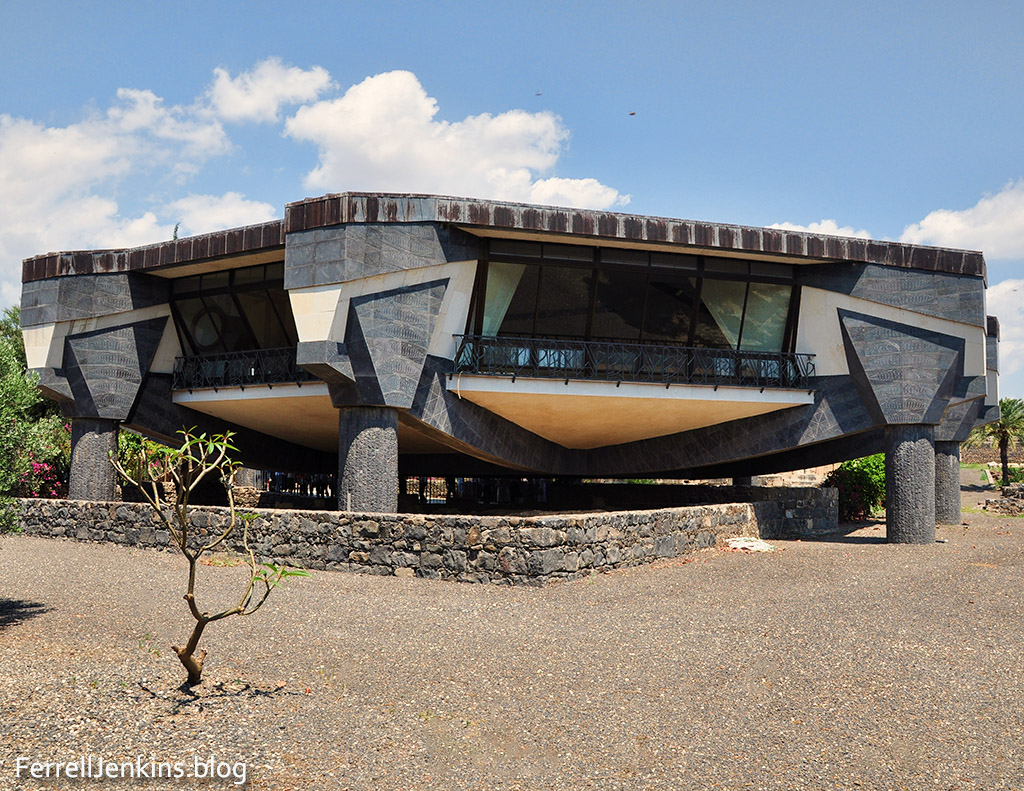
Today we will show you a significant change brought about by a new building. Having visited Capernaum many times since 1967 I have been able to see many changes. This church that some have described as looking like a space craft is built over the excavation of a Byzantine church that covered some of the first century houses. One of these house is said to have been designated as a place for Christians to meet. The Franciscans who own the property have designated this as the house of Peter. We know from Scripture that Peter lived here with his wife and mother-in-law (Matthew 8:14).

Capernaum was located on the frontier between the territory of Herod Antipas and that of Herod Philip. The city became important in the earthly ministry of Jesus. Notice just a few events that make it so significant.

  • Jesus settled here, making Capernaum His “own city” (Mark 1:232-34).
  • Many of the miracles of Jesus were performed here (Mark 1:21-28).
  • Matthew worked as a tax collector at Capernaum (Matthew 9:9).
  • Peter lived here (Matthew 8:14).

Capernaum was one of three cities of the area denounced by Jesus  on account of their failure to believe (Matthew 11:20-22 ESV).

If you visit Capernaum you will see the building pictured below that some have described as looking like a space craft. It was built about 1990. The entrance with steps leading up to the glass floor is on the west side of the building (to our left). Our photo shows the south side; we have our back to the Sea of Galilee. The building is located 84 feet south of the synagogue (*Strange).

Capernaum. The modern church erected in 1990 by the Franciscians. Photo: ferrelljenkins.blog.

This modern building was erected in 1990. It covers the excavated ruins of the octagonal Byzantine church and what some have said is the house of the apostle Peter. This view is to the north, with the Sea of Galilee to my back.The entrance steps are on the left, and the synagogue is on the other side of this building. Photo by Ferrell Jenkins.

James F. Strange says,

Friar Orfali had done some work on the octagonal building in the 1920s. His plan showed the building as consisting of three concentric octagons.

When the excavations were renewed by Corbo and Loffreda in 1968 they discovered a baptistry and an apse providing evidence that this was indeed an ancient church (Strange).

Strange says,

It is reasonable to assume, therefore, that this octagonal church at Capernaum was a memorial church. Some scholars believed that the octagonal church was built to memorialize Jesus’s temporary residence in Capernaum and may well have been connected with ancient memories or traditions regarding the location of St. Peter’s house, also called “the house of Simon and Andrew” in Mark 1:29.

Below is today’s Favorite Foto that I made in 1978. The floor of the new “memorial church” has a glass floor so that one can look below at the ancient structure. It is now difficult to make photos with ordinary photographic equipment because of the glare from the glass. Visitors to the site may also walk under the new church, but it is difficult to make sense of what is there.

Capernaum. The octagonal Byzantine church which is said to cover the house of the apostle Peter. Photo: ferrelljenkins.blog.

This is the way the excavated area of Capernaum looked in 1978. We see ruins of the octagonal Byzantine church which is said to have been built over the house of the apostle Peter. Photo by Ferrell Jenkins.

Strange says, “According to the excavators, the central hall of this church was originally built as part of a house about the beginning of the Early Roman period, around 63 B.C.”

I will leave it to you to investigate more about this structure and the possibility that Jesus visited this home during His personal ministry in Capernaum.

* Source: When you see the name *Strange in one of my comments it indicates that the information was quoted directly or gleaned from the following source:

Strange, James F., and Hershel Shanks. “Has the House Where Jesus Stayed in Capernaum Been Found?” Biblical Archaeology Review, vol. 8, no. 6, Oct. 1982. Biblical Archaeology Review. BAR.

If you are interested in a recent scholarly essay on the excavations at Capernaum see he following:

Mattila, Sharon L. Galilee in the Late Second Temple and Mishnaic Periods. Vol. 2, edited by David A. Fiensy and James R. Strange, First ed., Minneapolis, Fortress Press, 2015, 2 vols, pp. 217-57.

Special Note about the Fiensy-Strange Volumes: The two volumes by David A. Fiensy and James R. Strange, Galilee in the Late Second Temple and Mishnaic Periods…, are currently available in Kindle Format as follows: Vol. 1, 352 pages, for $4.99 (pb is $50.33). Vol. 2, 502 pages, for $6.99 (pb is $26.00). James R. Strange is the son of the late James F. Strange quoted in my post. I am pleased with the quality of the diagram and photos display.

Ferrell’s Favorite Foto # 35 – Roman Milestone

In the IVP Bible Background Commentary Craig Keener says,

Roman soldiers had the legal right to impress the labor, work animal or substance of local residents (cf. Mk 15:21). Although impressment may not have happened often in Galilee, it happened elsewhere, and the fact that it could happen would be enough to raise the eyebrows of Jesus’ hearers at this example of nonresistance and even loving service to the oppressor. (Keener, Craig S. The IVP Bible Background Commentary: New Testament. Downers Grove, IL: InterVarsity Press, 1993. Print.)

Though the milestone pictured below has been moved to the current location at Bethany Beyond (or across) the Jordan (in Jordan, John 1:28), it provided a beautiful setting. Our picture looks west to the Jordan Valley. The various buildings you see in the left part of the photo are mostly church buildings on the Jordanian side of the Jordan River. On the other side we see the eastern slopes of the Judean Wilderness. Jericho is in that general vicinity.

Milestone at Bethany Beyond the Jordan. Photo: ferrelljenkins.blog.

Roman period milestone at Bethany Beyond the Jordan. Photo by Ferrell Jenkins.

In the sermon recorded in Matthew 5-7 Jesus taught His disciples about the attitude they should have toward the Roman authorities.

And if anyone forces you to go one mile, go with him two miles. (Matthew 5:41 ESV)

New Testament writers gave distances in their descriptions of travel from one city to another. Luke says that Emmaus was about seven miles from Jerusalem (Luke 24:13). John says that Bethany [not Beyond the Jordan] was about two miles from Jerusalem (John 11:18).

Milestones were common in Roman times and numerous ones have been found throughout the land of Israel. Most of them have now been moved to some of the small museums found throughout the land. The same is true of some in Jordan.

Most of the Roman roads for which we have remnants were built in the second half of the first century A.D. and in the second century. Certainly in many cases it is reasonable to think that these roads were built over dirt paths that already existed.

For documentation about the Roman Road System in Galilee see James F. Strange, “The Galilean Road System,” in Galilee in the Late Second Temple and Mishnaic Periods, vol. 1, Life, Culture, and Society (ed. David A. Fiensy and James Riley Strange; Minneapolis: Fortress Press, 2014), 263-71 . Maps of the major and minor roads of Galilee are found in the front of the same volume.

David Graves has imposed known Roman roads in the vicinity of Bethany Beyond the Jordan on a Google Earth map here.

See one of our earlier post about Roman Roads and Milestones here.

Megiddo, Har Mageddon, Armageddon?

This morning’s Twitter feed brought a notice from Prof. Carl Rasmussen about a review of Eric Cline’s most recent book, Digging up Archaeology: The Search for the Lost City of Solomon by Andrew Robinson in Nature.

This is an interesting review about an important city in biblical history. I, too, think you will find it helpful, and you might decide you want to read Cline’s book. It is available at Amazon in print and Kindle format.

Here is one of my aerial photographs of Megiddo with a view of the Jezreel Valley and the hills of lower Galilee to the north. Perhaps you can use it in some of your teaching.

Megiddo and the Jezreel Valley. Photo: ferrelljenkins.blog.

View north of Tel Megiddo, the Jezreel Valley, and lower Galilee. Photo by Ferrell Jenkins.

We have several posts about Megiddo which you may locate by using the Search box. Perhaps the most general one which includes labeled panoramas of the Jezreel Valley may be found here.

The six water jugs at Cana of Galilee

A friend recently sent me a small photo and a few questions about the water jugs at Cana of Galilee (John 2).

Attached is a photo of a reproduction of what I suppose is a wine jug. It is about 30” tall and 20” handle tip to tip. I bought it a couple of months ago at an estate sale. The seller told us tongue in cheek that it may be the very one from which Jesus turned water into wine. I told him that, in spite of how old I might look and the fact that I had not attended the wedding, I could assure him it was NOT the same one!

An old jug

Is this like the jugs that held water at Cana of Galilee?

“My questions for you, Ferrell, are…

  • Is this a similar appearance and size of those of the First Century?
  • Is this type of jug sold in Israel as a souvenir?
  • I paid $30 for the jug and, of course, had no shipping. Did I get a bargain? I’m going to use it as a feature in my garden.”

The Gospel text says,

Now there were six stone water jars there for the Jewish rites of purification, each holding twenty or thirty gallons. (John 2:6 ESV)

The fact that the text says each jug would hold between twenty and thirty gallons indicate a larger jar than the one my friend bought. I have visited many museums, large and small, in Israel, as well as numerous antiquities shops, and do not recall seeing a jug like the one she bought.

Fortunately some of the jugs of the type mentioned in John 2 have been found in Jerusalem, Qumran, and other places. Notice the photo below from the Israel Museum. These are the jugs found in what we now call the Jewish Quarter of Jerusalem. Replicas are displayed in the Wohl Archaeological Museum at the place called the Herodian Mansion where they were found.

Large jars for water of purification in the Israel Museum.

These stone jars, along with stone tables, now displayed in the Israel Museum come from the Jewish Quarter of Jerusalem from the Herodian Period. Photo by Ferrell Jenkins.

A replica of one of these jars is displayed in the Hecht Museum at the University of Haifa. The sign explains the purpose of the jars and the way they were made.

Sign explaning the large stone jars used for purification. Hecht Museum.

This sign explains the type of jars we are showing here. Hecht Museum. Photo by Ferrell Jenkins.

The Hecht Museum is a great teaching museum. In the model house shown below you will see several of the stone jars used for the water of purification. This model reminds me a bit of the Burnt House in the Jewish Quarter of Jerusalem.

Model house from first century displayed at Hecht Museum, University of Haifa, Israel. Photo by Ferrell Jenkins.

The third question should have been asked prior to purchase. I have dealt with this question many times during my tours. Individuals come to me and say, “He is asking $___ for this item. Is that a good price?” I learned to say to tour members prior to visiting the first few shops that I will not be able to answer that question in the shop. If they purchased and then asked me if they got a good deal here is how I answered. If you like it and can afford it and are happy with it you got a good deal.

One other point should be made. The type of jar used for shipping and storing wine is known as an amphora. Imported jars such as this were also excavated in the Jewish Quarter.

An amphora fromthe Hellenistic Period. This one is displayed at the Hecht Museum, University of Haifa. Photo by Ferrell Jenkins.

An amphora from the Hellenistic period displayed at the Hecht Museum, University of Haifa ,Israel. Photo by Ferrell Jenkins.

The pointed bottoms were placed in sand to hold them erect for filling and transportation. Many pictures and drawings of amphora can be found here.

Addendum: Leon Mauldin sent the photo below showing the author standing beside the model and a replica of one of the water jars.

Ferrell Jenkins at the Hecht Museum, Haifa, Israel.

Ferrell Jenkins standing beside the model and one of the water jar replicas. Photo by Leon Mauldin.

Agreement of Book and Land: Have you heard of the Atad tree?

At Neot Kedumim most of the trees are identified by name and often with references to biblical events. I enjoyed seeing the Atad tree. The sign at the base of the tree explains an important biblical event which names the atad tree.

The atad tree in the parable of Jotham. Photo: ferrelljenkins.blog

This sign explains the biblical reference to the atad tree in the parable of Jotham in Judges 9. Photo by Ferrell Jenkins.

For ease of reading here is the first paragraph of the sign. Some of the spellings have been changed to make the information more easily understood by English readers.

A parable told by Jotham after the death of his father, Judge Gideon, criticizing his brother Abimelech’s rise to power after the latter brutally murdered all 70 of his other brothers “upon one stone” (Judges 9:5). The parable tells of the trees seeking to anoint a king. They ask the olive, fig, and grapevine who each refuse, wishing only to continue to bear their fruit. Eventually the Ziziphus spina-christi (atad), frequently – and misleadingly – mistranslated as a bramble, agrees to assume the role with devastating consequences: “let fire come forth from the atad” (Judges 9:15).

The Hebrew text uses the term atad for the plant. Common English translations include bramble, thronbush, and thorn bush. Some writers think of the atad as a tree, such as the one you see here.

The Atad tree at Neot Kedumim. Photo: ferrell jenkins..blog.

The Atad tree at Neot Kedumim. Photo by Ferrell Jenkins.

For other references to the Ziziphus spina-christi see our photos and information here and here (note the last photo in that post).

The next photo shows some of the worthless fruit on the atad tree at Neot Kedumim. In contrast the fruit of the olive, the fig and the grape vine was very useful.

The fruit of the Atad tree of Joshua 9:14-15. Photo by Ferrell Jenkins at Neot Kedumim.

The fruit of the Atad tree of Joshua 9:14-15. Photo by Ferrell Jenkins at Neot Kedumim.

Todd Bolen tells the backstory of BiblePlaces Photos

This morning I was pleased to receive the BiblePlaces Newsletter (Vol 19, #1). In it Todd Bolen reminds us that “twenty years ago this month, BiblePlaces.com was born.” He provides us with a brief history of the development of his Photo Collections.

The Pictorial Library of Bible Lands.

The Pictorial Library of Bible Lands – 18 volumes.

If you have ever used the images in The Pictorial Library of Bible Lands (now 18 volumes), The Photo Companion to the Bible, or one of the other resources developed under Bolen’s leadership, you know how valuable the material can be in teaching the Bible.

Bolen observes that he bought one of the set of 100 slides that used to be hawked by the guides on tours of Israel. My experience was much the same. Indeed, even if the photos were good but the quality of the duplication was not good.

I trust I have said enough to prompt you to read the current BiblePlaces Newletter here.

No free lunch, but a Free Powerpoint Presentation of Galilee: Then and Now is available (link at bottom of the Newsletter). Better than a lunch, I would say. I have traveled to Israel for the past 53 years and am aware of the numerous changes that have taken place in that time. In this slide presentation you will see changes back further with photos from the Historic Views of the Holy Land.

Thank you  Todd Bolen for this wonderful service you have provided to all teachers and preachers of the Bible.

Check our Index on Bethlehem & Birth of Jesus

We have a few indexes prepared of topics that have been covered widely on this blog. One is an Index of article on Bethlehem and the Birth of Jesus here. It also includes some articles about the origin of Santa Claus at Myra, Turkey. We encourage you to take a look at these articles.

Our photo was made from the Franciscian Shepherd’s field in Bethlehem and this is the first time we have used it. I call it Shepherd’s Field by Day.

 And in the same region there were shepherds out in the field, keeping watch over their flock by night. (Luke 2:8 ESV)

Shepher's Field by Day. Photo: ferrelljenkins.blog.

Shepherd’s Field by Day. Photo by Ferrell Jenkins.

It is not possible to post as often at this time as I did in years past, but I want to encourage you to use this site often in your Bible study. Use the Search box to locate posts about Bible places, people and customs. I think will enhance your study of the Bible.

Thanks for telling others about the blog.

Ferrell’s Favorite Foto # 33 – Cave of Adullam

In 2011 Leon Mauldin and I make arrangements to visit Tel Adullam and the Cave of Adullam. I had gathered some information from Prof. Carl Rasmussen and Gordan Franz about locating the site. We secured the services of a guide from the small town of Aderet, a moshav on the north side of Adullam. She took us to the site in a four-wheel drive vehicle and explained what we were seeing.

Tel Adullam is near the Valley of Elah where David had met and defeated Goliath (1 Samuel 17).

View from Tel Adullam. Photo: ferrelljenkins.blog.

Daphna, our guide, and Leon look east from Tel Adullam. Notice the central mountain range in the distance. Photo by Ferrell Jenkins.

Once we reached the forested mound we enjoyed a wonderful view to the east, and south. Our guide, Daphna, inquired first about our interest in the site. How did we even know about the site, she wondered. She is a Sabre, a native-born Israeli, who lives at Aderet.

There is a large cave at Adullam. Is it the cave where David stayed while fleeing from Saul? Can’t say, but if it was not this one it had to be another one near by. The next photo was made from inside the cave.

Inside the Cave of Adullam. Photo: ferrelljenkins.blog.

Inside the Cave of Adullam where David and his men stayed while fleeing from Saul. Photo by Ferrell Jenkins.

Adullam is significant in several biblical accounts. Here are a few.

Judah stayed with an Adullamite man named Hirah. He married the daughter of a Canaanite man named Shua.

At that time Judah left his brothers and stayed with an Adullamite man named Hirah. There Judah saw the daughter of a Canaanite man named Shua. Judah acquired her as a wife and had marital relations with her. (Genesis 38:1-2 NET)

The episode of Onan and his failure to fulfill his responsibility to bring up children to his deceased brother (the Levirate marriage; Genesis 38:3-10).

Joshua defeated the king of Adullam during the Conquest (Joshua 12:15), and became one of the Shephelah (lowland or hill country) cities of the tribe of Judah (Joshua 15:35).

The cave of Adullam is associated with David. When he left Gath he went to Adullam before sending his parents to Moab for safety.

So David left there and escaped to the cave of Adullam. When his brothers and the rest of his father’s family learned about it, they went down there to him. (1 Samuel 22:1 NET)

In fact, David spent much time at Adullam. I suggest you read the entire account in 2 Samuel 23:13ff.

When the prophet Micah warned Judah about the coming Assyrian invasion he said,

…the leaders of Israel shall flee to Adullam (Micah 1:15 NET)

Just as David did about three centuries earlier.

One more point. Jesus was a descendant of David and Judah, both of whom had an association with Adullam (Revelation 5:5).

What a wonderful experience.

Note: if you wish to locate the Adullam cave on Google Earth Pro, search for Aderet, Israel, and then look for the cave. Or use these coordinates: 31°39’02.33 N, 35°00’08.53 E.

Which photo is today’s favorite? Take your pick.

David leaves 200 men at the Brook Besor

In addition to the tours I led between 1967 and 2016 I have made numerous personal study trips with a variety of friends beginning as early as 1984. The largest number of those trips have been made with Leon Mauldin. On these trips we visit places that are difficult to reach by bus or take an unusual amount of time to reach — too time consuming for a group looking to see all they can in a typical 10-12 day tour.

In September, 2011, Leon and I spent some time in the south of Israel. One of the fascinating places we visited was the Brook Besor. Israelis call it Nahal Besor. Various English versions of the Bible use the terms Brook, brook or Wadi to describe the stream. For anyone who might wish to visit the area I will explain how we got there.

Using the modern maps at your disposal locate Beersheba (Be’er Sheva), then take highway 25 NW to highway 241 and turn left. Our first photo was made on the north side of highway 241 after we crossed the Besor.

Brook Besor on the north side of highway 241. Photo: ferrelljenkins.blog.

The Brook Besor on the north side of highway 241. Notice the typical dry terrain of the Negev in the background. Photo by Ferrell Jenkins.

Water is flowing somewhere among these reeds and during the winter rains we may be sure that the water is visible. Notice the dry terrain in the distance.

A short distance from the location of this photo, on the south side of the highway we saw this impressive mound. It is easy to reach, at least in dry weather, using the road across the fields.

Tel Sharuhen on the banks of Nahal Besor. ferrelljenkins.blog.

Tel Sharuhen on the banks of Nahal Besor. Most of the reeds like those we have shown in the photo above are on the opposite side of the tel. Photo by Ferrell Jenkins.

The Arab name for this archaeological mound is Tell el-Farah (South) to distinguish it from Tell el-Farah (North), the site of biblical Tirza near Shechem (1 Kings 15:33).

The Archaeological Encyclopedia of the Holy Land (1990) entry begins with this description of the Tell el-Farah (South).

The site is some 14 miles south of Gaza and 16 miles west of Beer-Sheba, near the ancient Via Maris (Roads) connecting Egypt and Mesopotamia. W.M.F. Petrie identified Tell el-Farah with Beth-Pelet (Josh. 15:27; Authorized Version: ‘Beth-Palet’), but W.F. Albright’s identification with Sharuhen (Josh. 19:6) is now accepted by most scholars. Apart from the biblical reference, Sharuhen appears three times in Egyptian sources of the New Empire: in the description of the Hyksos expulsion from Egypt, when Amosi besieged the Hyksos for three years at Sharuhen; in the records of the first campaign of Tuthmosis III; and in those of the campaign of Pharaoh Sheshonq.

Sharuhen is mentioned only once in the Bible as a city of the tribe of Simeon (Joshua 19:1-8; see especially verse 6).

This area looks rather hidden from society, but it was on two major international highways in biblical times.

Leon and I were looking for the possible site where David left 200 men who were too exhausted to make the trek to chase those who had burned Ziklag and taken several captives including two wives of David (1 Samuel 30; see especially verses 9, 10, and 21). I can easily envision this area being the place of the crossing of the Besor.

Ferrell Jenkins at Tel Sharuhen. ferrelljenkins.blog.

Brook Besor on the north side of Tel Sharuhen. This picture including Ferrell Jenkins was apparently made by Leon Mauldin. You have a nice view of the Brook Besor. Photo: ferrelljenkins.blog.

From the south side of the tel we took the steps (lower left corner of the photo) to the top.

Approach to Tel Shuarhen from the south. View of Brook Besor. Photo ferrelljenkins.blog.

Approach to Tel Sharuhen from the south. View of Brook Besor. Photo by Ferrell Jenkins.

The following signs in Hebrew and English identify the site as Tel Sharuhen.

Sign identifying Tel Sharuhen. Photo: ferrelljenkins.blog.

A nice sign identifying the tel as Tel Sharuhen. Photo by Ferrell Jenkins.

I was delighted when I saw these signs were  new.

Sign identifying Tel Sharuhen. Photo: ferrelljenkins.blog.

Sign in Hebrew and English identifying the mound as Tel Sharuhen. Photo by Ferrell Jenkins.

There are also signs at the site identifying Tel Sharuhen as part of the ANZAC Trail. This trail was made famous in 1917 when a light horse brigade of mostly Australian and New Zealand aboriginals defeated the Germans in the region.

The Anzac Trail of 1917. Tel Sharuhen is marked as number 6.

For those with further interest in the historic battle of 1917 I suggest two links. This link in the Times of Israel tells about the centennial retracing the route of the battle by descendants of the Aboriginal ANZAC soldiers in 2017.

More general information about the ANZAC Trail, including directions and a PDF of the map above, may be read here.

The seven photos in this post are sized suitable for use in a PowerPoint presentation for teaching.