Monthly Archives: July 2014

IAA Director General Dorfman died today at age 64

The Israel Antiquities Authority announces the passing of Yehoshua (Shuka) Dorfman today, July 31, 2014, at the age of 64. His passing came after what is described as a long battle with a serious illness.

Dorfman’s academic training was in Political Science. He served in a variety of military roles reaching the rank of Brigadier General. He was appointed director of the IAA in 2000.

IAA Director Shuka Dorfman. Photo: Israel Antiquities Authority.

IAA Director Shuka Dorfman. Photo: Israel Antiquities Authority.

HT: Joseph I. Lauer

The Tenth Roman Legion in Jerusalem

Students of the Bible are aware that the city of Jerusalem, including the Herodian temple, was destroyed by the Romans in A.D. 70. Vespasian commanded the Romans in the north of the country. When he learned of the death of Nero he began his return to Rome and left his son Titus in command of the military forces.

When Titus began to position his forces around the city of Jerusalem, he called the tenth legion from Jericho to come up to the Mount of Olives and take their position there.

and as these were now beginning to build, the tenth legion, who came through Jericho, was already come to the place, where a certain party of armed men had formerly lain, to guard that pass into the city, and had been taken before by Vespasian. These legions had orders to encamp at the distance of three quarters of a mile from Jerusalem, at the mount called the Mount of Olives, {c} which lies opposite the city on the east side, and is parted from it by a deep valley, interposed between them, which is named Kidron. (Josephus, Jewish Wars 5:69-70)

Jesus had prophesied about forty years earlier that the Holy City would be surrounded by armies.

But when you see Jerusalem surrounded by armies, then know that its desolation has come near. (Luke 21:20 ESV)

The word used for armies (stratopedon) is used in literature of the time to specify a legion or a camp (see BDAG and MM).

Archaeological discoveries have supplemented the writings of Josephus to provide evidence of the presence of the tenth legion in Jerusalem. In addition to the column near Jaffa Gate that we mentioned in the previous post, we here call attention to some other evidence that is readily available for anyone who wishes to see it. Here, I call attention to a Roman milestone.

Roman milestone found near the Temple Mount in Jerusalem mentions Vespasian, Titus, and the Tenth Legion. Displayed in Israel Museum. Photo by Ferrell Jenkins.

Roman milestone found near the Temple Mount in Jerusalem mentions Vespasian, Titus, and the Tenth Legion. Displayed in Israel Museum. Photo by Ferrell Jenkins.

The Israel Museum sign associated with the milestone reads,

Near the Temple Mount in Jerusalem, a milestone bearing a Latin inscription was discovered. The inscription mentions both the Roman emperor Vespasian and his son Titus, commander of the Roman army at the time of the suppression of the Great Revolt and had been deliberately effaced, seems to have mentioned the name of Flavius Silva, procurator of Judea and commander of the Tenth Legion, responsible for both the destruction of Jerusalem and the conquest of Masada. The inscription was carved by soldiers of the Tenth Legion.

I have a few more photos of artifacts mentioning the tenth legion that I hope to post soon.

More on Roman Roads and Milestones

We have had a few follow-up questions from our post on Roman Roads and Milestones. One reader asked on Facebook, “Is the milepost inside Jaffa Gate for real??”

If you enter the Old City of Jerusalem at Jaffa Gate you should turn left on the second street (lane would be better). You may not see the name, but it is Demetrius Street. A column, now serving as a lamppost, is actually a portion of an inscribed Roman column. Jerome Murphy-O’Connor (Holy Land, 5th edition) says the Latin inscription reads,

M(arco) Iunio Maximo leg(ato) Aug(ustorum) Leg(ionis) X Fr(etensis)—Antoninianae—C. Dom(itius) Serg(ius) str(ator)eius.

Roman column near Jaffa Gate. Photo by Ferrell Jenkins.

Roman column near Jaffa Gate. Photo by Ferrell Jenkins.

Murphy-O’Connor explains,

The inscription honours Macus Junius Maximus, Legate of the Augusts (i.e. the emperor Septimius Severus and his eldest son Caracalla), which implies that he was the governor of the province of Judaea, and Legate of the Tenth Legion Fretensis.

The column was erected about A.D. 200. Hoade (Guide to the Holy Land) says the once-taller column “was scalped by a bomb in 1948.” [See comment below by Tom Powers, with link to a photo of the column made in the 1930s.] This column is comparable to a milestone but apparently never served that purpose. The camp of the Tenth Roman Legion was immediately south of this place in the area now occupied by the Armenian Quarter. After the destruction of Jerusalem by the Romans, Titus allowed the Tenth Legion to remain in Jerusalem.

[Titus] … permitted the tenth legion to stay, as a guard at Jerusalem, and did not send them away beyond the Euphrates, where they had been before; (Josephus, Wars of the Jews 7:17)

Close-up of Roman column mentioning 10th Roman legion. Photo by Ferrell Jenkins.

Close-up of Roman column mentioning 10th Roman legion. Photo by Ferrell Jenkins.

What is a mile? Another reader asked, “How does the mile mentioned in the NT (I would assume the Roman mile) compare in length to our mile?”

The Greek term used in Matthew 5:41 is milion. BDAG says the term is used of “a Roman mile, lit. a thousand paces, then a fixed measure = eight stades = 1,478.5 meters.”

But the term used in Luke 24:13 and John 6:19 is stadion. This term is defined as “a measure of distance of about 192 meters, stade, one-eighth mile” (BDAG). This word also came to mean “an area for public spectacles, arena, stadium.” This is the term translated race in 1 Corinthians 9:24.

Our English versions typically adapt the Greek term stadion “to familiar measurements of distance” (Louw-Nida).

When is a gate not a gate? Rethinking the Lachish discovery

Last Monday, following material posted by Luke Chandler, I posted a blog here with this heading: “Have new gates been discovered at Lachish?”

Yesterday Luke posted a clarification here that was sent to him by the Fourth Lachish Expedition director Yossi Garfinkel. Garfinkel suggests that the new architectural features discovered at Lachish probably should not be called “gates.” He says there are no chambers on both sides of the opening. He says, “so we might have simple openings in the city wall rather than official gates.” The first opening had already been noted by Olga Tufnell after the first expedition at Lachish by Starkey. Tufnell said it was a “blocked Iron Age” gate. Garfinkel thinks it “is probably a Middle Bronze blocked gate.”

Prof. Garfinkel says the second opening found this year is “dated to Level I (Persian) and Level II (586 BC destruction), so this opening is not ‘Early Iron Age’ as [Chandler] wrote.”

This illustrates one of the reasons archaeologists often withhold their findings from the public until they can be more certain about what they have, and even then they point out that the findings are preliminary.

I have dabbled in archaeology enough through personal study, participation at Lachish in 1981, and attendance at the annual meetings of the professional societies fairly regularly for the past 40 years, to know that interpretations change from day-to-day, and season-to-season. Patience is recommended.

Chambered gate at Gezer. Photo by Ferrell Jenkins.

Chambered gate at Gezer. Photo by Ferrell Jenkins.


Göbekli Tepe excavator Klaus Schmidt dead at 61

The Turkish newspaper Hurriyet Daily News reports the death of Professor Klaus Schmidt.

Professor Klaus Schmidt, a pioneer of excavations in Göbekli Tepe, known as the “zero point in history” in the eastern Turkish province of Şanlıurfa, died of a heart attack while swimming in Germany at the age of 61.

Schmidt had been working at Göbekli Tepe for 20 years for the German Archaeology Institute. Through his works, he proved that the Neolithic-age ancient site was the world’s oldest temple.

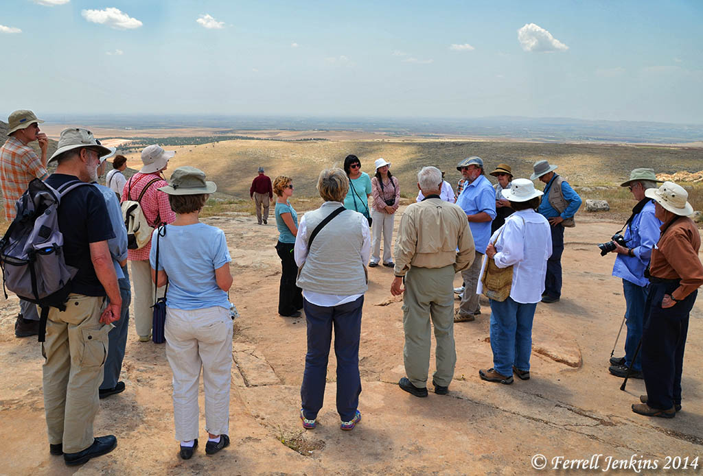
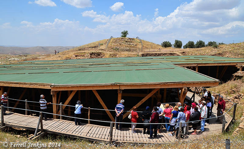
When Leon Mauldin and I visited Göbekli Tepe in May of this year Schmidt was providing a personal tour for an educational tour group from the United States. He is wearing a light blue shirt and a cap (just right of center). We followed along for a while and listened to his explanations. I thought it might be Schmidt but wasn’t sure until I checked for photos on the Internet at the hotel that evening.

Professor Klaus Schmidt lecturing to an American group at Gobekli Tepe. Photo by Ferrell Jenkins.

Professor Klaus Schmidt lecturing to a group at Gobekli Tepe. Photo by Ferrell Jenkins.

Schmidt explains the site and significance of Göbekli Tepe.

Göbekli Tepe is one of the most fascinating Neolithic sites in the world. It is a tell, an artificial mound dating to the Pre-Pottery Neolithic. It was not used for habitation; it consists of several sanctuaries in the form of round megalithic enclosures. The site lies about 15km north-east of the Turkish city of Sanlıurfa, at the highest point of an extended mountain range that can be seen for many kilometres around. It is a landmark visible from far away…. Its enormous deposition of layers, up to fifteen metres high, have accumulated over several millennia over an area of about nine hectares. Even today, the place has lost nothing of its magic appeal. For example, a wishing tree which stands on top of the ridge is still sought out by the residents of the surrounding area.

Archaeologists found an important piece of the puzzle in the early history of humanity at the site, which contributes to a completely new understanding of the process of sedentism and the beginning of agriculture. The hill, which is strewn with countless stone implements and large-format, regular-shaped ashlars, revealed its secret as a result of the excavations carried out since 1995 by the German Archaeological Institute in cooperation with the Archaeological Museum in Sanlıurfa (Schmidt 1995). (DOI: 10.4312/dp.37-21)

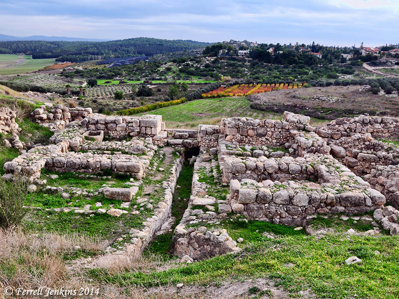
The photo below shows the enclosure protecting the T-shaped monolithic pillars.

The enclosed area of Gobekli Tepe. Photo by Ferrell Jenkins.

The enclosed area of Gobekli Tepe. Photo by Ferrell Jenkins.

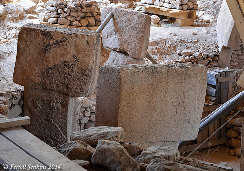
A Google search for Göbekli Tepe will produce numerous images of he site before the protective roof was built. A popular article in Actual Archaeology is available at Academia.edu here. It is now difficult to get photos of many of the pillars. See the article by Schmidt here. Some of the pillars are plain, but many of them contain reliefs of animals, birds, and a few humans. The art looks like what we might expect of children, but these pillars are definitely not the work of children.

Some of the T-shaped monolithic pillars. Photo by Ferrell Jenkins.

Some of the T-shaped monolithic pillars. Photo by Ferrell Jenkins.

Göbekli Tepe is no more than 30 or 40 miles north of Harran (or Haran), the ancient home of Abraham (Genesis 11:21). Muslim belief says that Abraham was born at nearby Sanliurfa.

Schmidt explained to the American group that this site marked the change from the time of hunter-gatherers to a time of domestication of plants and animals.

There are many mysteries associated with Göbekli Tepe. The death of Schmidt is a blow to the continued work at the site, but perhaps others will be able to provide helpful information in the future.

Additional Photos (July 23, 2014). Carl Rasmussen has added several photos of Göbekli Tepe prior to the building of the roof over the excavated area. These photos allow you to see the arrangement of the stones. Go to his Holy Land Photos’ Blog here.

HT: Joseph I. Lauer

Have new gates been discovered at Lachish?

Luke Chandler has reported the identification of new entrances to the ancient city of Lachish here. The late Iron Age gate where the Lachish Letters were discovered is marked by an oval (almost circle). This is the entry to the site used by tourists who visit.

The newly-identified entrances are in the area of the rectangle marking. This is the area where most (or all) of the current excavations have been conducted.

Aerial view of Lachish showing Iron Age gate (oval), and the earlier gate (rectangle). Photo by Ferrell Jenkins.

Aerial view of Lachish showing Iron Age gate (oval), and the earlier gate (rectangle). Photo by Ferrell Jenkins.

Chandler says that the newly-identified entrances have preliminary dating to the earlier Iron Age [1200-900 BC, the period of the Judges and the United Kingdom] and the Middle Bronze periods [2050-1550 BC, the period of the Patriarchs]. He says this is where Prof. Yosef Garfinkel plans to begin the 2015 season of excavations.

Chris McKinny, a staff member of the Tel Burna Excavation Project, discusses the importance of the discovery if one of the gates does prove to belong to the “early Iron Age.” He says,

If this is in fact a gate that can be dated to the “early Iron Age,” then this is a very important discovery for reconstructing Israel/Judah’s geopolitical character in the 10th and 9th centuries BCE.

Read his full discussion at Bible Places.


Roman Roads and Milestones

A new website devoted to Roman Roads and Milestones in Judaea/Palaestina has recently come to our attention. This site is co-sponsored by the Kinneret College on the Sea of Galilee Department of Holy Land Studies and Tel Aviv University IMC-Israeli Milestone Committee. Most readers will know that Kinneret is the Hebrew name for the Sea of Galilee. The website includes articles by the late Israel Roll and others, as well as maps showing the location of the roads. Many of the articles are in Hebrew or another language other than English. The maps, however, should be useful to those who do not read Hebrew.

The English website is available here. (If it links to the Hebrew page look in the upper left hand corner and click on EN.)

Good Bible atlases include a map of the known roadways. See, for example, the following:

  • Rasmussen, Zondervan Atlas of the Bible. Rasmussen includes a map showing the Natural Routes/Roads, and a discussion of International Routes.
  • Beitzel, The New Moody Atlas of the Bible. Beitzel includes a map showing The Roads of Palestine and a discussion of the principles back of making decisions about the roads.
  • Schlegel, Satellite Bible Atlas. The second map in this atlas shows the Regions and Routes of the Land of Israel.

Our photo below shows remains of the Roman road that Jesus might have taken from near Nazareth to the Sea of Galilee. These roads are often in danger of destruction by careless builders and farmers.

The Roman Road near Golani Junction in Galilee. This road collected Diocaesarea (Zephoris) and Tiberias. Photo by Ferrell Jenkins.

The Roman Road near Golani Junction in Galilee. This road connected Diocaesarea (Zephoris) and Tiberias. Photo by Ferrell Jenkins.

Jesus taught His disciples about the attitude they should have toward the Roman authorities.

And if anyone forces you to go one mile, go with him two miles.(Matthew 5:41 ESV)

New Testament writers gave distances in their descriptions of travel from one city to another. Luke says that Emmaus was about seven miles from Jerusalem (Luke 24:13). John says that Bethany was about two miles from Jerusalem (John 11:18).

Milestones were common in Roman times and numerous ones have been found throughout the land of Israel. I understand that the milestone below is from the Jezreel Valley. It is one of many displayed on the grounds of the Beit-Sturman Museum near En Harod.

Roman Milestone from the Jezreel Valley. Photo by Ferrell Jenkins.

Roman Milestone from the Jezreel Valley. Photo by Ferrell Jenkins.

HT: Jack Sasson

Gaza is in the news again

After my first tour to the Bible Lands, including Rome, Greece (Athens and Corinth), Egypt, Lebanon, Syria (Damascus), Jordan, and Israel, in April/May, 1967, I decided to make a second tour the following year. For many years, I always added some new places on each tour. In 1968 I added Beersheba and Gaza. The Gaza Strip (named such because of the long, narrow size of the small entity) had been under Egyptian control for several decades until June, 1967
There was not much to see at Gaza. By the time we visited in 1968, Gaza was under Israeli control. We drove to the coast where there were only a few houses and some small fishing boats. This is one of the few slides that I have to illustrate the visit to Gaza.

Gaza on the Mediterranean Sea in May, 1968. Photo by Ferrell Jenkins.

Gaza on the Mediterranean Sea in May, 1968. Photo by Ferrell Jenkins.

Gaza is mentioned several times in the Old Testament. Here is a summary of these references.

  • Gaza was the southwestern boundary of the Canaanites in the table of Nations (Genesis 10:19).
  • The original inhabitants of Gaza were replaced by the Caphtorim, likely the ancestors of the Philistines (Deuteronomy 2:23).
  • Joshua defeated Canaanites “even as far as Gaza” (Joshua 10:41).
  • Joshua eliminated the Anakites except in Gaza, Gath, and Ashdod (Joshua 11:21-22). We recognized these cities as later belonging to the Philistines.
  • Gaza is listed as belonging to the tribe of Judah (Joshua 15:47; Judges 1:18).
  • The Midianites oppressed Israel, “as far as Gaza”, for seven years (Judges 6:4).
  • Samson had contact with the inhabitants of Gaza (Judges 16).
  • Gaza is listed as one of the five Philistine cities in the time of the Israelite Judges (1 Samuel 6:17).
  • Solomon controlled territory as far southwest as Gaza (1 Kings 4:24).
  • Hezekiah defeated the Philistines as far as Gaza and its territory (2 Kings 18:8).
  • Jeremiah makes reference to Gaza being conquered by Pharaoh (Jeremiah 47:1).
  • The prophets of Judah pronounced judgments upon Gaza (Amos 1:6-7; Zephaniah 2:4; Zechariah 9:5).

The only New Testament reference to Gaza is in Acts 8:26. Philip the evangelist was instructed to go south on the road that descends from Jerusalem to Gaza. English translators struggle with the issue of whether the city was desert, or the road leading to the city ran through a desert area. (I will leave that for some other time.)

The first display one sees as he enters the archaeology wing of the Israel Museum is that of the anthropoid coffins from Deir el-Balah, a site south of Gaza city. The coffins, excavated by Trude Dothan in 1972, bear evidence of Egyptian influence. They date to the 13th century B.C.
Anthropoid Coffins from Deir el-Balah in the Israel Museum. Photo by Ferrell Jenkins.

Anthropoid Coffins from Deir el-Balah in the Israel Museum. Photo by Ferrell Jenkins.

Reprint from January 7, 2012.

John was “on the island called Patmos”

John, the writer of the book of Revelation, was “on the island called Patmos, because of the word of God and the testimony of Jesus” (Rev 1:9). I am convinced that this was the apostle John. He was there because of (Greek dia, on account of) the word of God. Filson says this could mean either banishment, or banishment to hard labor. He points out that the word of God and witness or testimony are used in Revelation 6:9 and 20:4 “in reference to a persecution situation” (Interpreter’s Dictionary Bible III:677).

The Romans used the island as a penal settlement to which they sent political agitators and others who threatened the peace of the empire (Tacitus Annals 3.68; 4.30; 15.71). According to Eusebius, John was banished to Patmos by the Emperor Domitian, A. D. 95, and released 18 months later under Nerva (HE III.18.1; 20.8-9).

View of the port of Skala from Chora. Photo by Ferrell Jenkins.

View of the port of Skala from the monastery at Chora. Photo by Ferrell Jenkins.

Patmos is a rocky island off the west coast of Asia Minor in the Aegean Sea, about 37 miles southwest of Miletus. The island is one of the Dodecanese (twelve) or of the Southern Sporades. It is about 10 miles long (N–S) and 6 miles wide at the north end, and consists of about 22 square miles of land area. The island is mountainous and of irregular outline. Some visitors to the island have suggested that the natural scenery “determined some features of the imagery of the Apocalypse” (HDB III:693-94).

Patmos has been a part of Greece since 1947, and may be reached by boat from Piraeus, Samos, Kos, or Rhodes. The ferry from Samos takes about 2 1/2 hours, arriving at the port of Skala. Some cruise ships sail from Kusadasi, Turkey, to Patmos.

On the way from Skala to Chora, the only other town on the island, one passes the Monastery and Cave of the Apocalypse. This site is marked as the traditional place where John received the Revelation.

At Chora, the monastery of St. John the Theologian dominates the island. It was built by a monk called Christodulos (slave of Christ) in A. D. 1088. The monastery library is noted for its manuscripts, but especially for its collection of more than 200 icons. The oldest book in the library is part of a 6th century codex of Mark (Codex Purpureus). The second oldest manuscript is an 8th century A. D. copy of Job.

Bell tower on the Monastery of St. John the Theologian at Chora. Photo by Ferrell Jenkins.

Bell tower on Monastery of St. John the Theologian at Chora. Photo by Ferrell Jenkins.

The Bosphorus − “a liquid line”

For years I have received Saudi Aramco World (Saudi was added to the name a few years ago). From time to time there are articles pertaining to some portion of the Bible World. The March/April 2014 issue has an article by Louis Werner entitled “Bosporus: Strait Between Two Worlds.” The leading paragraph sets the tone for the article.

Look at an atlas of the oceans, and one place always seems to catch the eye. The Bosporus, that narrow waterway connecting the Black Sea to the Sea of Marmara, which cuts the city of Istanbul into two halves, stands out alone among the world’s other major straits and canals. Along with the wider twin, the Dardanelles, the Bosporus famously divided east and west, while the rest − the Suez and Panama Canals, the Malacca and Magellan Straits, to name but a few − link different regions.

Its function as a barrier between continents, a liquid line strung between Europe and Asia, has given the Bosporus such prominence in both history and legend: The ancient Greeks sailed up the strait to their Black Sea colonies, the Persian King Darius built a floating bridge across it in the fifth century BCE; in 1451 CE, Mehmet the Conqueror built a fort on its European bank to strangle Constantinople; during the Cold War, Joseph Stalin said that Turkish control over the Bosporus held the USSR “by the throat”; today it is an essential part of global shipping trade in petroleum.

The Bosphorus (more common spelling) has fascinated me since I first saw it in 1968. I have enjoyed looking at the great vessels traveling one way or the other through the waterway. Tour groups enjoy a boat ride on the Bosporus. The photo below shows one of the more narrow areas. Cargo ships can be seen awaiting their turn to go through the strait.

Cargo and tourists making their way through the Bosporus. Photo by Ferrell Jenkins.

Cargo and tourists making their way through the Bosporus. Photo by Ferrell Jenkins.

In the past we have written about the delivery of Peter’s epistles with the suggestion that the messenger came through the Bosphorus into the Black Sea and along the coast of Bithynia and Pontus. If this is correct, and I think it is, the Bosphorus was an important waterway to those Christians addressed by Peter. See “The Delivery of Peter’s Epistles” here.