Monthly Archives: November 2009

More on the Magdala Excavation Project

Fishhook from the 2008 Magdala Project dig.

Fish-hook from the 2008 Magdala Project dig.

The Magdala Project blog is giving some info on the current excavations at the site of Magdala on the west short of the Sea of Galilee. Reports include information on the first century synagogue, a 2006 preliminary report, and ship iconography as portrayed on mosaics of the first to third centuries AD.

Several nice photos are included on the blog including one of a fish-hook discovered  from the 2008 Magdala Project dig, and a stone anchor from the 2007 season.

The article by K. C. Hanson on “The Galilean Fishing Economy and the Jesus Tradition” is extremely helpful for those seeking to understand the role of the disciples of Jesus who were fishermen.

The photo of the fish-hook  provides a nice illustration of a text from Matthew 17:24-27.

When they came to Capernaum, the collectors of the two-drachma tax went up to Peter and said, “Does your teacher not pay the tax?” He said, “Yes.” And when he came into the house, Jesus spoke to him first, saying, “What do you think, Simon? From whom do kings of the earth take toll or tax? From their sons or from others?” And when he said, “From others,” Jesus said to him, “Then the sons are free. However, not to give offense to them, go to the sea and cast a hook and take the first fish that comes up, and when you open its mouth you will find a shekel. Take that and give it to them for me and for yourself.” (Matthew 17:24-27 ESV)

We have mentioned Magdala several times. Check here, and use the Search box for other references.

HT: Bible Places Blog

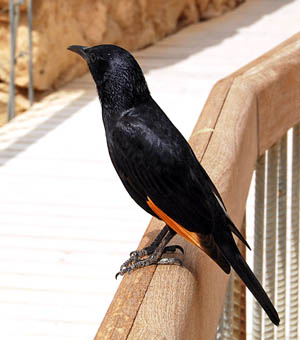
Tristram’s Grackle at Masada

Tristram's Grackle at Masada. Photo by Ferrell Jenkins.

Tristram's Grackle at Masada. Photo by Ferrell Jenkins.

Henry B. Tristram wrote The Natural History of the Bible in 1868. In 1884 he wrote Fauna and Flora of Palestine. I have not personally used his books, but I have seen numerous quotations from them in sources describing the plants, animals, and birds of Palestine.

A bird commonly seen at Masada, along the shore of the Dead Sea, is named for Tristram. This black bird with some distinctive orange feathers is known as Tristram’s Grackle, or Tristram’s Starling.

Thanksgiving Day – 2009

Oh give thanks to the LORD, for he is good, for his steadfast love endures forever! (Psalm 107:1 ESV)

Shepherd with sheep in the Land of Ararat. Photo by Ferrell Jenkins.

Shepherd with sheep in the Land of Ararat. Photo by Ferrell Jenkins.

Jabbok River valley inhabited and irrigated for millennia

A recent report by Dutch researchers calls attention to the relation of the irrigation, especially that in the Zerqa River triangle of Jordan, to population and the nature of the communities.

You can make major discoveries by walking across a field and picking up every loose item you find. Dutch researcher Eva Kaptijn succeeded in discovering – based on 100,000 finds – that the Zerqa Valley in Jordan had been successively inhabited and irrigated for more than 13,000 years. But it was not just communities that built irrigation systems: the irrigation systems also built communities.

Archaeologist Eva Kaptijn has given up digging in favour of gathering. With her colleagues, she has been applying an intensive field exploration technique: 15 metres apart, the researchers would walk forward for 50 metres. On the outward leg, they’d pick up all the earthenware and, on the way back, all of the other material. This resulted in more than 100,000 finds, varying from about 13,000 years to just a few decades old. Based on further research on the finds and where they were located, Kaptijn succeeded in working out the extent of habitation in the Zerqa Valley in Jordan over the past millennia.

Read the longer report here.

The Zerqa River is known as the Jabbok in the Bible. It is probably best known as the place where Jacob met with Esau as he returned from Paddan Aram, and where his name was changed to Israel (Genesis 32).

The same night he arose and took his two wives, his two female servants, and his eleven children, and crossed the ford of the Jabbok. (Genesis 32:22 ESV)

Jordan utilizes the water of the Jabbok (Zerqa) for irrigatation, especially in the Jordan Valley. This photo which I made last year shows the Jabbok a few miles from the Jordan Valley. The mountains are in the Biblical land of Gilead. Before the river reaches this point much of the water has been caught in reservoirs for use by the Jordanians.

The Jabbok (Zerqa) River near the Jordan Valley. Photo by Ferrell Jenkins.

The Jabbok (Zerqa) River near the Jordan Valley. Photo by Ferrell Jenkins.

HT: Biblical Paths.

Unique Archaeology Map of the West Bank and East Jerusalem

Suzanne Muchnic, of the Los Angeles Times, reports on a new online map that will be of interest to students of the archaeology of Palestine. Here is a portion of that report.

A searchable map detailing 40 years of Israeli archaeological work in the West Bank and East Jerusalem, developed for the USC Digital Library, has won the 2009 Open Archaeology Prize from the American Schools of Oriental Research.

Project leaders Lynn Swartz Dodd of USC and Rafi Greenberg of Tel Aviv University are expected to accept the award on behalf of an international team composed of Americans, Israelis and Palestinians.

The West Bank and East Jerusalem Digital Map

The digital map apparently won the approval of jurors because it offers a body of information previously unavailable to the public about sites surveyed or excavated since 1967, when Israel occupied the West Bank and East Jerusalem.

USC’s website is part of an effort to establish a framework for the disposition of the region’s cultural heritage in the event of a peace agreement between Israel and Palestine. Interactive satellite maps on the website show about 7,000 archaeological locales, including Shiloh, where the original tabernacle of the Hebrews is thought to have been located, and the Qumran caves, where the Dead Sea scrolls were found.

The public can access the West Bank and East Jerusalem Archaeology Database at http://digitallibrary.usc.edu/wbarc. Users must have Google Earth to get full use of the information.

Read the complete article in The Los Angeles Times. A UCLS news release may be read here.

This is a remarkable map. It includes only sites in the West Bank and East Jerusalem that have been surveyed or excavated. A search may be made by archaeological period, or by type: burial, cave, cistern, winepress, synagogue, mikveh, tell, etc.

I have added a link to this map on the Biblical Studies Info Page under Scholarly/Archaeology.

This video features Lynn Swartz Dodd and Ran Boytner discussing the importance of this project.

Earlier we reported here on the interactive map of the Dead Sea by A.D. Riddle and David Parker showing the history of change. We look forward to more material of this sort in the years to come as scholars make their information available to the wider public.

HT: Joseph Lauer.

Missing the professional meetings in New Orleans

Normally I would have been in attendance at some of the annual professional meetings being held this year in New Orleans. I have another extended trip planned in December and thought it best not to try to afford to attend the professional meetings. I am speaking of the ETS, NEAS, SBL, and the ASOR meetings.

There will be a lot of good reports coming from these meetings in some of the other blogs. Earlier in the year we reported on our friend Luke Chandler who was working in the excavation at Khirbet Queifaya, a site that overlooks the Valley of Elah, and possible associated with the account of David and Goliath in 1 Samuel 17. Luke has been attending the ASOR (American Schools of Oriental Research) meetings. We are not surprised that he reports first on the sessions devoted to Khirbet Queifaya. He provides a summary of the sessions here. Thanks, Luke.

View from Khirbet Queifaya toward Azekah. Photo by Luke Chandler.

View from Khirbet Queifaya toward Azekah. Photo by Luke Chandler.

Earthquakes still a problem in the Middle East

The Israel Antiquities Authority and the National Commission for UNESCO say that “Heritage sites in Israel are in danger of being destroyed in the event of natural disasters.” The meeting of international experts took place in the Crusader fortress at Akko.

Jerusalem, Masada, Caesarea … are they here to stay? The Israel Antiquities Authority and the Israel National Commission for UNESCO (the United Nations Education, Scientific and Cultural Organization) have warned today (Wednesday) that the heritage sites in Israel are at risk of destruction in the event of natural disasters and being vandalized by man.

Not only Israel, but Jordanian sites such as Petra are in danger of earthquake damage. Other sites in Israel, such as Ashkelon and Caesarea, are in danger of erosion and collapse. Then, there is always the problem of vandalism.

Repairing the wall of the Crusader Fortress at Akko. Photo: IAA.

Fortifying the wall of the Crusader Fortress at Akko. Photo: IAA.

The complete report may be read here. The report included this photo showing repair being made on the walls of Akko.

Akko (or Acre) is known in the many English versions of the Bible as Acco (Judges 1:31). In New Testament (Roman) times the city was call Ptolemais (Acts 21:7).

The Great Rift runs all the way from northern Syria through Lebanon, Israel, the Arabah, and into eastern Africa. In Israel the area is called the Jordan Valley or the Dead Sea Rift, It is not surprising that earthquakes are mentioned frequently in the Bible. The prophet Amos dates his visions to “two years before the earthquake” (Amos 1:1). The earthquake he makes reference to must have been so memorable that everyone would know what he was talking about. Zechariah (14:5) also calls attention to this earthquake in the days of Uzziah king of Judah.

Jesus, in predicting the fall of Jerusalem to the Romans, said, “and in various places there will be famines and earthquakes” (Matthew 24:7; see Luke 21:11).

We have a wonderful example of the power of an earthquake in the Jordan Valley at the site of Bethshan [Bet-she’an, Beth-shean], about 25 miles south of the Sea of Galilee. The city was destroyed by an earthquake in A.D. 749. This photo shows the evidence brought to light during recent archaeological excavations in the city.

Earthquake damage at Beth-shean in the Jordan Valley. Photo by Ferrell Jenkins.

Earthquake damage at Beth-shean in the Jordan Valley. Photo by Ferrell Jenkins.

HT: Joseph I. Lauer

Bible Mapper — Version 4 now available

Several times, including here, I have called attention to David Barrett’s Bible Mapper program. Version 3 remains a free program, but Barrett has now published version 4. The cost is $37. The web site describes Bible Mapper in these words,

Bible Mapper is a fully interactive, highly accurate Bible mapping system that helps you quickly and easily create customized maps of the Holy Lands or study a particular period and aspect of Bible history.

Based on my limited use of Version 3 I will say that the learning curve is fairly high, but the result can be gratifying. I have made several maps to teach specific portions of scripture, or the movement of certain characters.

There are many new features in version 4, including a gallery of 35 ready made maps. Take a look at the gallery when you check the web page. Complete information is available here. The map below is a reduced one from the gallery. The sample maps in the gallery are full size, but they all have the word SAMPLE on them — until you buy the registration key and unlock them on your computer. The 35 maps, even without the program, is worth the $37 it will cost you.

The Battle at Mount Gilboa. Bible Mapper.com.

The Battle at Mount Gilboa. Bible Mapper.com.

The maps in the ESV Study Bible were made with Bible Mapper.

HT: Todd Bolen, Bible Places Blog.

Another aerial view of Tel Dor

This view of Tel Dor and the Mediterranean coast was made in 2000 by the well-known photographer Zev Radovan. Look through almost any Bible Dictionary or other well illustrated book on Bible subjects and you will see some photos credited to Zev. Back in 2000, when I was still teaching at Florida College I approached Zev about making some photos for our use in teaching.

It took a couple of months before he had a good day to make these photos. Several times he sent Emails to let me know he was ready and had the helicopter reserved when the weather was good. I think this was made in May.

Aerial view of Tel Dor and the Mediterranean coast. Photo by Zev Radovan.

Aerial view of Tel Dor and the Mediterranean coast. Photo by Zev Radovan.

The photo we published here on November 16 was made looking north. This one is made looking south-east. Even though the tel is not shown as large in this photo, you will see that considerable archaeological work has been done in the past 9 years. You know that in those days photos were still being made in 35mm slide format.

An impressive location, indeed.

Take a look at Zev Radovan’s Bible Land Pictures Photo Archives here. Zev told me an interesting story back in 2000. He said that years earlier he could go out into the countryside and easily find a man plowing with a wooden plow pulled by a donkey. Now, in 2000, he said he would go out and find a man plowing, but with a cell phone on his belt. It has become difficult to find the biblical-type scenes as the country has become more mechanized.

Ephesus: “Turkey’s ancient splendour”

A recent article in stuff.co.nz calls Ephesus “Turkey’s ancient splendour.” Here a few excerpts from the article by Brenda Webb of the Marlborough Express.

The ruins of Ephesus on Turkey’s west coast are among the best preserved and most impressive in the Mediterranean.

Imagine 250,000 people living in an area roughly the size of Picton township [a New Zealand town of about 3000 population].

Throw in an amphitheatre that seats 25,000 people, a massive three-story library, several temples, an agora (market place), a brothel, Roman baths complex, a gymnasium and various basilicas, temples and fountains.

This gives some idea of the size and complexity of the amazing ancient city of Ephesus, one of the 12 cities of the Ionian League and a once thriving Mediterranean port where skillful artisans and rich merchants gathered.

Today it’s a frantically busy historical site, so it’s best to visit early morning or late afternoon and avoid peak holiday season of July and August.

Half an hour inland from the Turkish coastal city of Kusadasi, Ephesus retains much of its former grandeur thanks to sensitive excavation and preservation that began around 100 years ago and continues today, with only 20 per cent of the site uncovered.

It certainly is a work in progress – the day we visited a huge crane was removing rubble from yet another new excavation site beside the magnificent amphitheatre that took 60 years to build.

In was here that gladiatorial combats were said to be held during Roman times as well as less brutal concerts and theatrical performances.

The acoustics in the amphitheatre are fantastic. We watched and listened in awe as an Italian tourist recited poetry on the stage, his words clearly reaching us some distance away.

Ephesus was first inhabited as long ago as 6000 BC but reached its peak in Roman times and most of the remains you see today date from then.

Despite its age and years of plundering, Ephesus remains surprisingly intact, especially its marble streets, the much photographed library and massive amphitheatre.

Some of the best-preserved artefacts, statues and tools have been taken to the nearby Ephesus Museum in Selcuk but some amazing structures remain and it is its completeness that gives it the edge over other historical sites in the Mediterranean.

Read the rest of the article here.

The Arcadian Way - Ephesus

The Arcadian Way runs from the Theater (to our back) and the harbor (now silted up). Photo by Ferrell Jenkins.

Luke describes some of the work of Paul at Ephesus in these words:

And he entered the synagogue and continued speaking out boldly for three months, reasoning and persuading them about the kingdom of God. But when some were becoming hardened and disobedient, speaking evil of the Way before the people, he withdrew from them and took away the disciples, reasoning daily in the school of Tyrannus. This took place for two years, so that all who lived in Asia heard the word of the Lord, both Jews and Greeks. (Acts 19:8-10 NAU)

For the full account of Paul’s work in Ephesus read Acts 18-20.

HT: Biblical Paths.