Monthly Archives: August 2017

New books from Carta Jerusalem

Carta Jerusalem, publisher of some wonderful resources about the Bible, Biblical History, and the Bible Land, recently sent me several new books. I will make brief mention of these books in hope that you will check the Carta online catalog to learn more. The books also are available from Amazon and some other publishers.

Understanding Hezekiah of Judah (Rebel King and Reformer) by Mordechai Cogan. This full-color paperback is 9″ x 11¾”, 40 pages. The book is based on the Bible and extra-biblical sources including archaeological discoveries. $14.95.

Carta Jerusalem's new Understanding Hezekiah of Judah.

Carta Jerusalem’s new Understanding Hezekiah of Judah.

Understanding the Holy Temple Jesus Knew (The Background to Key Gospel Events) by Leen and Kathleen Ritmeyer. This full-color paperback is 9″ x 11¾”, 48 pages. $14.95. We have frequently mentioned the superb work of the Ritmeyer’s on the temple that Jesus knew.

Leen and Kathleen Ritmeyer's Understanding the Holy Temple Jesus Knew.

Leen and Kathleen Ritmeyer’s Understanding the Holy Temple Jesus Knew.

Understanding the Israelite-Samaritans (From Ancient to Modern) by BenyamimTsedaka. This full-color paperback is 9″ x 11¾”, 40 pages. The author is an Elder of the Samaritan community living in Israel. Having visited the Samaritan community on Mount Gerizim, I found this work to be extremely interesting. $14.95.

Understanding the Israelite-Samaritans by Carta Jerusalem.

Understanding the Israelite-Samaritans by Carta Jerusalem.

The Carta books mentioned above are lavishly illustrated with photos, drawings, and maps.

In a future post or two I will mention a few more of the new books supplied by Carta Jerusalem.

The women of Mount Samaria are like the cows of Bashan

Amos of Tekoa is recognized as a straight forward, no-nonsense, prophet (Amos 1:1). He called the women of the northern kingdom of Israel cows. Nothing politically correct about that.

Listen to this message, you cows of Bashan who live on Mount Samaria! You oppress the poor; you crush the needy. You say to your husbands, “Bring us more to drink!” (Amos 4:1 NET)

The sn (study note) in the NET Bible is worth reading.

The expression cows of Bashan is used by the prophet to address the wealthy women of Samaria, who demand that their husbands satisfy their cravings. The derogatory language perhaps suggests that they, like the livestock of Bashan, were well fed, ironically in preparation for the coming slaughter. This phrase is sometimes cited to critique the book’s view of women.

Bashan is in the area we now call the Golan Heights. It is located to the east of the Sea of Galilee and northward. Golan in Bashan was one of the cities of refuge located in the territory of eastern Manasseh (Joshua 20:8). The region was noted as good pasture land.

In the modern state of Israel we notice an attempt to grow crops known from biblical times in the same area where they were grown then. And the same is true of cattle. Here is a photo I made earlier this year of some of the cows grazing in ancient Bashan (modern Golan Heights).

Cows grazing in the Golan Heights, the area known as Bashan in Old Testament times. Photo by Ferrell Jenkins.

Cows grazing in the Golan Heights, the area known as Bashan in Old Testament times. Photo by Ferrell Jenkins.

The solar eclipse of June 15, 763 B.C.

I watched the solar eclipse on TV. Now you might enjoy going to the link I mention below.

Carl Rasmussen has posted an interesting article on his HolyLandPhotos’Blog here about “A Solar Eclipse and Old Testament Chronology.” He says,

But did you know that the solar eclipse of June 15, 763 B.C. holds the key to the chronology of the Old Testament (Hebrew Bible)?

He continues to explain how we are able to know the date for certain Old Testament kings and events. We are all dependent on the work of scholars such as the late Edwin R. Thiele (1895-1986) and his The Mysterious Numbers of the Hebrew Kings.

How are we to convert the relative dates given in the Bible (e.g., “in the fourth year of…”) to absolute dates (e.g., 966 B.C.)?

The Assyrians kept records of their kings and various officials on these stone documents called limmus, but in one of them they recorded the eclipse of the sun that occurred June 15, 763 B.C. according to astronomical computation.

Limmu stelae from Asshur. Museum of the Ancient Orient, Istanbul, Turkey. Photo by Ferrell Jenkins.

Limmu stelae from Asshur. Museum of the Ancient Orient, Istanbul, Turkey. Photo by Ferrell Jenkins.

I confess to having made the above photo of the limmu stelae from Asshur, displayed in the Museum of the Ancient Orient in Istanbul, Turkey, but failing to photograph the identifying sign.

Carl’s post and photo was enlightening to me. He explains about the limmu stelae and how Thiele used this material to develop a widely accepted Biblical Chronology. I urge you to read his article, and perhaps Thiele’s book. The book is available from Amazon and other sources.

The water system at Megiddo

Ancient people built their villages and towns near water sources. If there was not a spring at the base of the hill where they settled they would need to dig a well, a shaft, or a tunnel to reach the water source.

Many visitors to Israel have made their way through the water system at Megiddo. Professor David Ussishkin, who is able to include Megiddo among his numerous excavations, says,

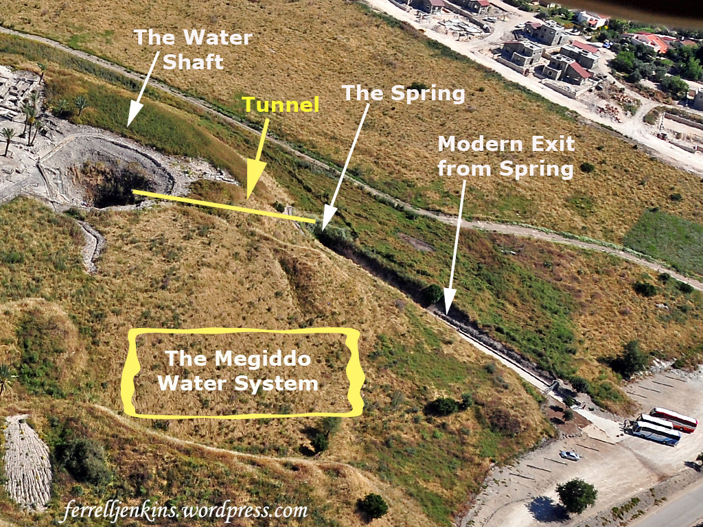
As mentioned before, there were two springs at Megiddo. The nearer one was located on the western side, at the bottom of the mound. There were two obvious difficulties in the use of the water by the inhabitants of the city. First, in order to obtain water for daily use, the inhabitants – and these were most probably the ladies – had to descend the steep slope down to the spring and then carry the water in jars back to their homes which were situated on the summit of the mound. Second, in time of siege, the spring remained outside the city-walls, and thus inhabitants could not reach it while the besieging army had easy access to the water. These difficulties were overcome by constructing a huge water system (Figs. 2.5; 2.22; 2.27). A vertical shaft was cut in the rock from the surface of the mound. Starting from the bottom of the shaft, a horizontal tunnel was cut in the rock till it reaches the spring. At the same time the approach to the spring from outside was blocked and hidden from view. The way to the spring now became easier and safer: one had to descend by rock-cut steps down the vertical shaft, and then walk through the horizontal tunnel to the spring.

In a later stage, the bottom of the horizontal tunnel was lowered, so that the water flowed by gravitation from the spring to the bottom of the vertical shaft. From here, the water could be raised with the aid of pulleys to the surface of the mound, saving a lot of work and energy.

Naturally, as time passed and the settlement was abandoned, the water system was filled with debris. The Chicago expedition [1933-1939] made a huge effort excavating and cleaning up the water system, restoring the steps in the vertical shaft, and preparing the place for visitors. The water system is now one of the major attractions for visitors to Megiddo.
Source: Ussishkin, David. On Biblical Jerusalem, Megiddo, Jezreel and Lachish. Hong Kong: Divinity School of Chung Chi College, Chinese University of Hong Kong. 2011: 66-67.

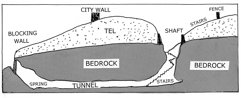
The sign at the entrance to the water system was in poor condition when I made my photo. I have made a drawing based on that sign showing the various elements of the system.

The Megiddo water system. Based on the sign at the site.

The Megiddo water system. Based on the sign at the site.

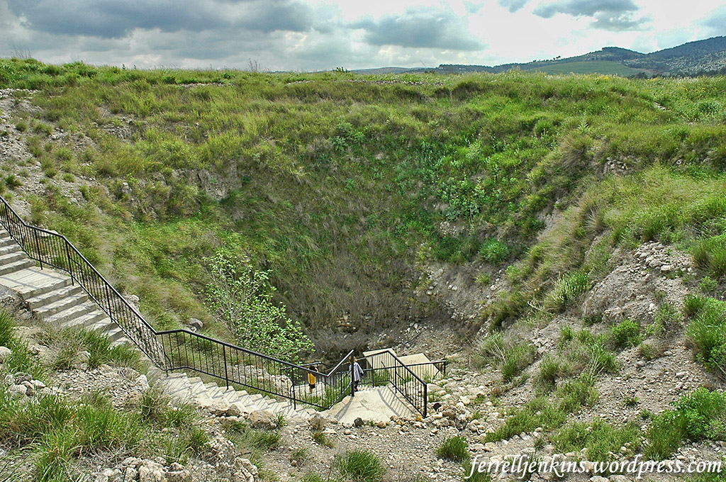
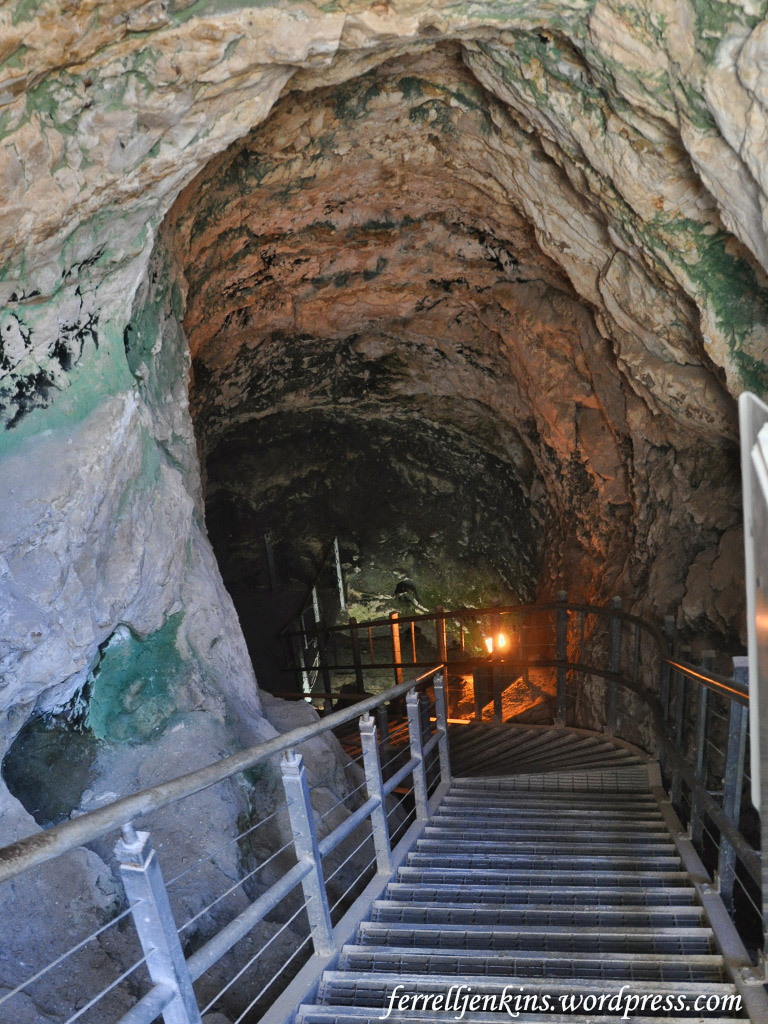
Our photos will take you through the water system step by step. The first photo shows a view of the entrance to the system from the top of the tel.

The shaft of the Megiddo water system from the top of the tel. Photo by Ferrell Jenkins.

The shaft of the Megiddo water system from the top of the tel. Photo by Ferrell Jenkins.

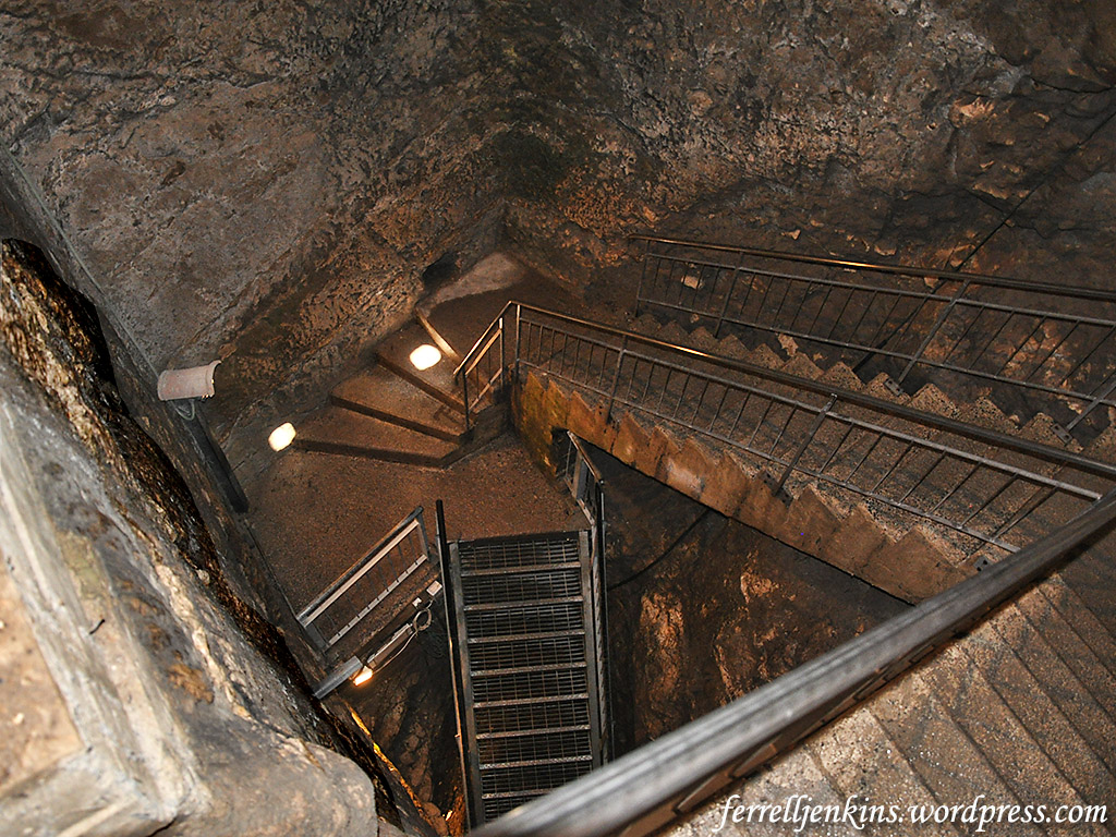
I see a variety of figures regarding the depth of the shaft and the length of the tunnel. The brochure distributed by the Israel Nature and Parks Authority says the shaft is 36-meters-deep [119 feet]. (Download the brochure here.) There are more than 180 steps down to the tunnel.

The same brochure says,

The tunnel was cut on an incline so the water would flow to the bottom of the shaft and the inhabitants could draw water while standing at the top. The outer entrance to the spring was sealed with a massive stone wall, concealed with earth so that an enemy besieging the city would not discover its location.

Steps going down to the level of the tunnel. Photo by Ferrell Jenkins.

Steps going down to the level of the tunnel. Photo by Ferrell Jenkins.

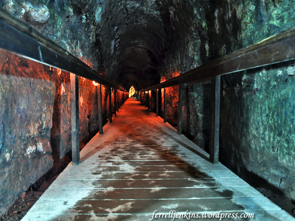
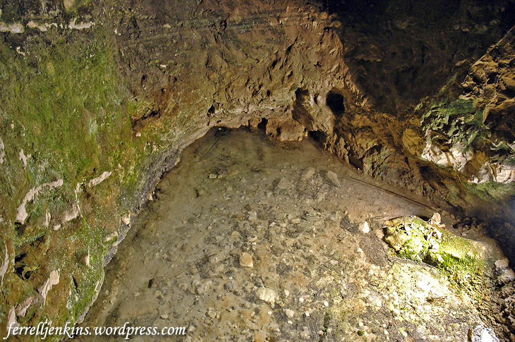
The water flowed from the spring on the western side of the tel through a 70-meter-long [230 feet] tunnel. I have never seen the water in the tunnel, but I recall a few times when tours were not allowed to go through the tunnel due to high water.

The tunnel at Megiddo with a modern walk for ease of traversing the length. Photo by Ferrell Jenkins.

The tunnel at Megiddo with a modern walk for ease of traversing the length. Photo by Ferrell Jenkins.

Only a small amount of water was seen at the spring in this 2006 photo.

The spring at it was on April 02, 2006. Photo by Ferrell Jenkins.

The spring at it was on April 02, 2006. Photo by Ferrell Jenkins.

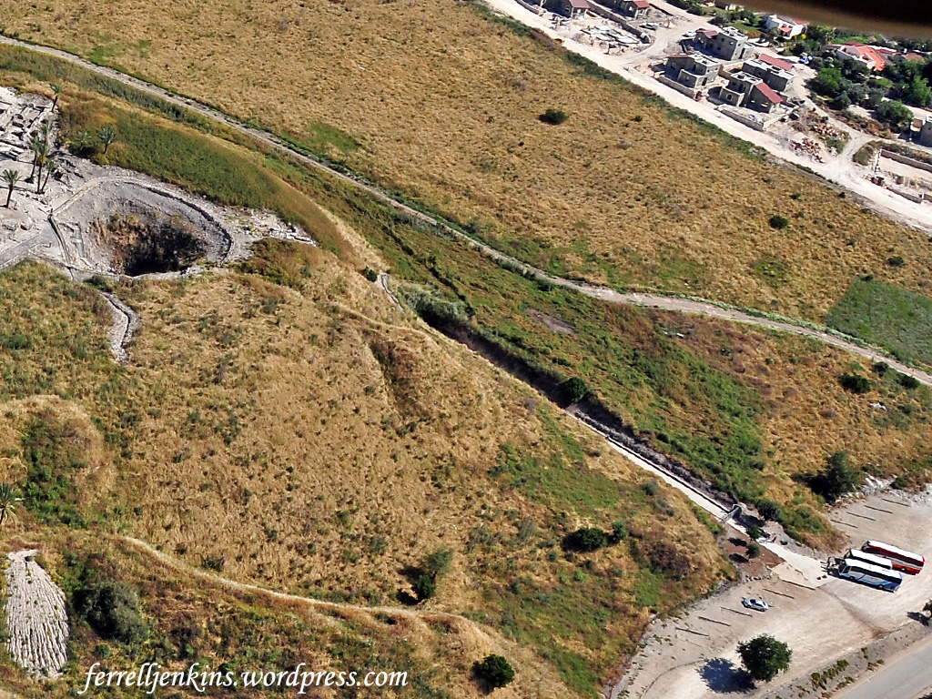
The aerial photo below shows the portion of the tel where the water system is located. You can see the opening of the shaft, and you can see there the tour buses are parked awaiting the tourists who have visited the tel and walked through the tunnel. A modern cut has been made to the modern steps leading to the spring.

Aerial view of the Megiddo water system. Photo by Ferrell Jenkins.

Aerial view of the Megiddo water system. Photo by Ferrell Jenkins.

Our next image is the same photo annotated to show the various parts of the system. Compare this with the drawing above.

Annotated aerial photo showing elements of the water system. Photo by Ferrell Jenkins.

Annotated aerial photo showing elements of the water system. Photo by Ferrell Jenkins.

The next photo was made near the top of the steps that lead from the spring to the exit.

After exiting the tunnel, this is the view down the steps to the spring. Photo by Ferrell Jenkins.

After exiting the tunnel, this is the view down the steps to the spring. Photo by Ferrell Jenkins.

During the early days of my visits I prepared a book about places we visited throughout the Bible Lands. In 1976 the book was published under the title The Book and the Land. In it I stated the understanding at the time that the water system dated to the 12th century B.C. (p. 63)

In the most recent tour guide (2016) I said,

A water system and tunnel which brought water from a spring outside the city is now thought to belong to the time of Ahab.

Chris McKinny gives the dates of Ahab’s reign as 874-863 B.C. in The Regnal Chronology of the Kings of Judah and Israel.

Not all of the smart people live in the 21st century A.D.

Now Available: Photo Companion to the Bible

If you received the Bible Places Newsletter today you already know about the Photo Companion to the Bible: The Gospels. For those who may not be subscribed to the Newsletter I wish to direct you to information about this new, highly significant resource.

This PowerPoint-based resource provides illustrations for almost every verse of the text. The advertisement describes the Photo Companion to the Bible this way:

More than 10,000 images illustrating Matthew, Mark, Luke, and John with modern and historic photographs of ancient sites, museum artifacts, and cultural scenes.

Cover of the Photo Companion to the Bible: The Gospels.

Cover of the Photo Companion to the Bible: The Gospels.

You may already own the Pictorial Library of Bible Lands and the Historic Views of the Holy Land. This new resource has photos, including many new ones, organized by chapter and verse for each of the four gospels. In fact, each chapter is illustrated by 40 to 230 photographs. The entire set contains more than 10,000 images.

When I looked through Matthew 4 I was impressed with the large number of illustrations. This means the teacher or preacher will be able to use these PowerPoint images to enhance his or her presentation. The audience will see and understand things about the text that they have never quite understood before.

There is a brief YouTube video illustrating what the Photo Companion to the Bible is and how it works. There are two chapters available for free download.

BiblePlaces.com is offering a deep discount price from now through August 21. I urge you to take advantage of it.

This new resource has been created by a team of professors and scholars under the direction of Dr. Todd Bolen who lived and taught in Israel for a decade or more and has traveled extensively in the Bible Lands. He is now a professor at Master’s University in California.

I have heard very few sermons or classes that could not have been greatly improved by the proper use of these illustrations of Bible lands and customs.

During my years of teaching and preaching I often paid for my own resources, but the positive response from the audience made it worthwhile. I hope to learn that many of you will be ordering this set.

All the information you need to place an order may be found here.

To subscribe to the BiblePlaces Newsletter see here.

To see a copy of the August 14, 2017 BiblePlaces Newsletter click here.

The significance of Megiddo and the Jezreel Valley

From Tel Megiddo one has a good view of the Jezreel Valley. Our panorama is composed of three photos made from the same spot at Megiddo. The Jezreel Valley lies before us to the north (and slightly east). Nazareth is located in the mountains of lower Galilee. The valley continues east between the Hill of Moreh and Mount Gilboa to Beth-Shean, the Jordan Valley, and the mountains of Gilead. The valley was known by the Greek name Esdraelon in New Testament times.

It was almost inevitable that those traveling from Babylon, Assyria, the territory of the Hittites, or Syria to Egypt, would travel through the Valley of Jezreel. The site of Jezreel is between the Hill of Moreh and Mt. Gilboa. (More about this at another time.)

Panorama of Jezreel Valley from Megiddo. Photo by Ferrell Jenkins.

Panorama of Jezreel Valley from Megiddo. Photo by Ferrell Jenkins.

For teaching purposes you may wish to use this annotated panoramic photograph. Click on the photos for the larger size suitable for Powerpoint.

Annotated panorama of Jezreel Valley from Megiddo. Photo by Ferrell Jenkins.

Annotated panorama of Jezreel Valley from Megiddo. Photo by Ferrell Jenkins.

The vicinity of the Valley of Megiddo (Jezreel/Esdraelon) was the scene of many significant historical battles. In The Battles of Armageddon Eric H. Cline lists 35 battles fought or still to come in the Jezreel Valley. Many of these battles have to do with the Romans versus the Jewish Resistance, the Muslims and the Crusaders, and a few 19th century battles. I am listing some of the more significant battles affecting Biblical history.

  • Thutmose III of Egypt fought Syrian forces – 1468 B.C.
  • Joshua defeated the King of Megiddo – Joshua 12:21.
  • Deborah and Barak defeated the Kings of Canaan – Judges 5:19.
  • Gideon defeated the Midianites – Judges 7.
  • Saul was defeated by the Philistines – 1 Samuel 28-31.
  • Ahaziah, king of Judah, died there – 2 Kings 9:27.
  • King Josiah was slain in a battle against Pharaoh Neco of Egypt – 2 Kings 23:29-30; 2 Chronicles 35:20-27.

Megiddo, the tell overlooking the valley, became typical of national grief and a symbol of decisive battles, similar to modern Waterloo, the Alamo, or Pearl Harbor. No wonder it provides the symbolism for the decisive battle in Revelation 16.  John’s Greek Har-Magedon becomes the English Armageddon.

The NAU transliterates harmagedon as Har-Magedon. Other English versions use something similar to the ESV.

And they gathered them together to the place which in Hebrew is called Har-Magedon. (Revelation 16:16 NAU)

And they assembled them at the place that in Hebrew is called Armageddon. (Revelation 16:16 ESV)

This valley has been significant even in modern times. Here are just a few of those battles laying the foundation for the modern State of Israel.

  • Napoleon advanced against the Turks in 1799.
  • General Allenby and the British defeated the German-Turkish coalition in 1918.
  • British officer Orde Wingate trained Jewish defense forces in this valley in the 1930s. Later leaders of the War of Independence (1948-1949), including Moshe Dayan and Yigal Alon, were trained by Wingate.

General Allenby read the historical survey about the importance of the valley in G. A. Smith’s Historical Geography prior to his battle against the German-Turkish coalition in 1918. In the later editions of his book Smith included that battle.

In a future post, perhaps later this week, I plan to discuss the water system at Megiddo.

The wild goat of the Bible identified as the Ibex

Wild goats (Hebrew ya’el) are mentioned in a few Old Testament passages (1 Samuel 24:2; Job 39:1; Psalm 104:18; Prov. 5:19). This animal is often identified with the Ibex.

The ibex, a type of wild goat, is still found in Southern Palestine, Sinai, Egypt and Arabia; it was known also in ancient times, as is evident from rock carvings. (Fauna and Flora of the Bible, 46).

The wild goats are associated with En Gedi on the shore of the Dead Sea.

Now when Saul returned from pursuing the Philistines, he was told, saying, “Behold, David is in the wilderness of Engedi.” Then Saul took three thousand chosen men from all Israel and went to seek David and his men in front of the Rocks of the Wild Goats. (1 Samuel 24:1-2 NAU)

Our photo below was made at En Gedi.

Ibex at En Gedi. Photo by Ferrell Jenkins.

A large Ibex at En Gedi. Photo by Ferrell Jenkins.

The Psalmist says the high mountains are for the wild goats.

The high mountains are for the wild goats; The cliffs are a refuge for the shephanim. (Psalm 104:18 NAU)

The final photo today shows an Ibex on the high rocks of the Negev near Ein Avedat, about 40 miles south of Beersheba. She has paused for her little one. Look carefully below the neck of the mother. Only the head of the kid is visible. Click on the photo for a larger, clearer image.

An Ibex in the Negev near Ein Avedat. Photo by Ferrell Jenkins.

An Ibex in the Negev near Ein Avedat. Photo by Ferrell Jenkins.