Tag Archives: Favorite Foto

Ferrell’s Favorite Foto # 33 – Cave of Adullam

In 2011 Leon Mauldin and I make arrangements to visit Tel Adullam and the Cave of Adullam. I had gathered some information from Prof. Carl Rasmussen and Gordan Franz about locating the site. We secured the services of a guide from the small town of Aderet, a moshav on the north side of Adullam. She took us to the site in a four-wheel drive vehicle and explained what we were seeing.

Tel Adullam is near the Valley of Elah where David had met and defeated Goliath (1 Samuel 17).

View from Tel Adullam. Photo: ferrelljenkins.blog.

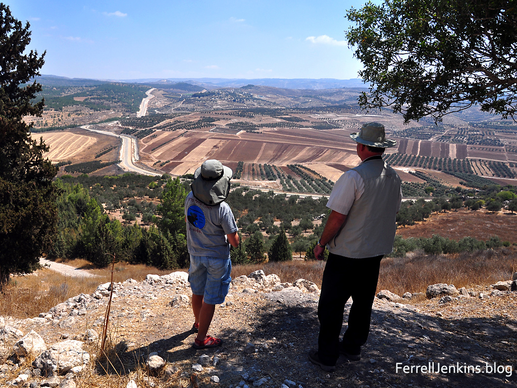
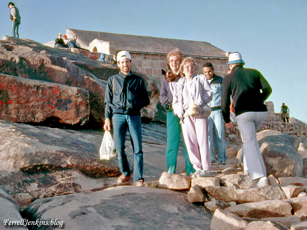
Daphna, our guide, and Leon look east from Tel Adullam. Notice the central mountain range in the distance. Photo by Ferrell Jenkins.

Once we reached the forested mound we enjoyed a wonderful view to the east, and south. Our guide, Daphna, inquired first about our interest in the site. How did we even know about the site, she wondered. She is a Sabre, a native-born Israeli, who lives at Aderet.

There is a large cave at Adullam. Is it the cave where David stayed while fleeing from Saul? Can’t say, but if it was not this one it had to be another one near by. The next photo was made from inside the cave.

Inside the Cave of Adullam. Photo: ferrelljenkins.blog.

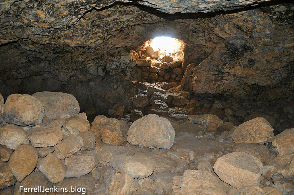
Inside the Cave of Adullam where David and his men stayed while fleeing from Saul. Photo by Ferrell Jenkins.

Adullam is significant in several biblical accounts. Here are a few.

Judah stayed with an Adullamite man named Hirah. He married the daughter of a Canaanite man named Shua.

At that time Judah left his brothers and stayed with an Adullamite man named Hirah. There Judah saw the daughter of a Canaanite man named Shua. Judah acquired her as a wife and had marital relations with her. (Genesis 38:1-2 NET)

The episode of Onan and his failure to fulfill his responsibility to bring up children to his deceased brother (the Levirate marriage; Genesis 38:3-10).

Joshua defeated the king of Adullam during the Conquest (Joshua 12:15), and became one of the Shephelah (lowland or hill country) cities of the tribe of Judah (Joshua 15:35).

The cave of Adullam is associated with David. When he left Gath he went to Adullam before sending his parents to Moab for safety.

So David left there and escaped to the cave of Adullam. When his brothers and the rest of his father’s family learned about it, they went down there to him. (1 Samuel 22:1 NET)

In fact, David spent much time at Adullam. I suggest you read the entire account in 2 Samuel 23:13ff.

When the prophet Micah warned Judah about the coming Assyrian invasion he said,

…the leaders of Israel shall flee to Adullam (Micah 1:15 NET)

Just as David did about three centuries earlier.

One more point. Jesus was a descendant of David and Judah, both of whom had an association with Adullam (Revelation 5:5).

What a wonderful experience.

Note: if you wish to locate the Adullam cave on Google Earth Pro, search for Aderet, Israel, and then look for the cave. Or use these coordinates: 31°39’02.33 N, 35°00’08.53 E.

Which photo is today’s favorite? Take your pick.

Ferrell’s Favorite Foto # 32 – the beauty of the simple

The water of Laodicea, site of one of the seven churches mentioned in the book of Revelation, came from hot springs immediately south of the city. By the time the water reached Laodicea it was lukewarm.  Jesus described the church as being like the water supply of the city.

“I know your works: you are neither cold nor hot. Would that you were either cold or hot! So, because you are lukewarm, and neither hot nor cold, I will spit you out of my mouth.” (Revelation 3:15-16 ESV)

Laodicea was one of three cities of the Lycus River Valley in Asia Minor (Colossians 2:1; 4:15-16). Today this area is in Turkey. Toward the end of the first century the book of Revelation was sent to several churches of Asia (Revelation 1:11).

This photo shows part of the water distribution tower at ancient Laodicea. Mount Cadmus, location of Laodicea, is seen in the distance.

Part of the water distribution system of ancient Laodices in Asia Minor (modern Turkey). Photo: ferrelljenkins.blog.

Ruins of the ancient water distribution system at Laodicea. Mount Cadmus, the location of Colossae, is visible in the distance. Photo by Ferrell Jenkins.

Notice in the previous photo to the right of the ruins you will see several people gathered. They are looking at the calcified clay pipes that once distributed water to the residences of Laodicea. When the water left the spring it was warm, but by the time it arrived at Laodicea it was lukewarm.

How here is our favorite foto for today.

Some fern, grain and tiny flowers grown in the calcified pipe that once brought water to Laodices. Photo: ferrelljenkins.blog.

This picture shows one of the broken clay pipes in the water distribution system, now calcified. But notice the little plants growing in the pipe. Photo by Ferrell Jenkins.

A florist could hardly do better. This pipe apparently became so clogged that dirt could settle in it and provide a bed for these little plants.

Ferrell’s Favorite Foto # 26 – Shepherds by Night

Luke’s account of the birth of Jesus mentions the shepherds “out in the field, keeping watch over their flock by night.”

7 And she gave birth to her firstborn son and wrapped him in swaddling cloths and laid him in a manger, because there was no place for them in the inn. 8 And in the same region there were shepherds out in the field, keeping watch over their flock by night. (Luke 2:7-8 ESV)

I have made many photos of shepherds and sheep over the years, but not many at night. However, in 2006 I visited with some shepherds at Heshbon, Jordan, one afternoon. I inquired about what they did with the sheep at night and decided to return about sundown to make some photos. The photo shown here has been lightened some to allow you to see the sheep in the sheepfold.

A shepherd watches his flock by night at Heshbon. Photo by Ferrell Jenkins.

A shepherd watches his flock by night at Heshbon. Photo by Ferrell Jenkins.

Just to the right of the center of the photo you should be able to see one of the shepherds with his back to the sheepfold. Click on the photo for a larger image suitable for use in teaching.

Ferrell’s Favorite Foto #22

This unusual photo of Capernaum was made from the hill above, up toward the Mount of Beatitudes. The photo shows the northeast corner of the Sea of Galilee with the Golan Heights visible.

Capernaum became the Galilean center for the ministry of Jesus.

And leaving Nazareth he went and lived in Capernaum by the sea, in the territory of Zebulun and Naphtali, (Matthew 4:13 ESV)

Capernaum from above the location on the Sea of Galilee. Photo: ferrelljenkins.blog.

View to the east of Capernaum from above the site. Photo by Ferrell Jenkins.

This photo was made May 15, 2010. The sky was fairly clear and the eastern shore of the Sea of Galilee is visible with perhaps a portion of the Plain of Bethsaida. Those are dried thistles in the foreground of the photo.

Ferrell’s Favorite Foto # 18

The island of Malta is mentioned in the book of Acts as the place where Paul was shipwrecked during the voyage to Rome.

After we were brought safely through, we then learned that the island was called Malta. (Acts 28:1 ESV)

Saint Paul's Bay and Island in Malta. Photo: FerrellJenkins.blog.

Saint Paul’s Bay and Island in Malta. Photo by Ferrell Jenkins.

There are several natural bays and harbors at Malta that have been suggested as the place of the shipwreck described in Acts 27-28. Saint Paul’s Bay is thought by some scholars to be the place where two sea met (Acts 27:41). Several English versions follow this reading (for example: NAS, NAU, NKJ, KJV)

The new Photo Companion to theBible: Acts contains photos of all of the places where the shipwreck could have occurred.

Ferrell’s Favorite Foto # 17

The Dead Sea is called the Salt Sea in the Bible (Gen. 14:3; Num. 34:3,12). The four kings of the east “joined forces in the Valley of Siddim (that is, the Salt Sea)” to fight against the five kings of the local region (Genesis 14:3 ESV).

Salt deposits on rocks along the shore of the Dead Sea. Photo: FerrellJenkins.blog..

Salt deposits on rocks along the shore of the Dead Sea. Photo by Ferrell Jenkins.

There is an extraordinary evaporation in the sea. After evaporation, the remaining water contains about 25% of solid substances with chloride of sodium (common salt) contributing 7%. It has a bitter and nauseous taste, due to the chloride of magnesium. The chloride of calcium makes it smooth and oily to the touch.

Josephus knew the Dead Sea as Lake Asphaltites in Roman times (Ant. 1.174; 15:168).

Ferrell’s Favorite Foto # 16

In April, 1986, arrangements were made for my travel group to leave Israel from Eilat and travel to Mount Sinai for an overnight stay. Opportunity was given for those who wished to climb the traditional mountain where Moses was given the Law (Exodus 20-24). Only four of the group chose to do so.

The peak known as Jebel Musa (Mount Moses) is thought by many to be the Mount Sinai of the Bible. Beginning at Saint Catherine’s monastery it takes about two hours and thirty minutes to climb to the top where the elevation is more than 7,500 feet. We began at 3:05 a.m. and made it to the top in time to see the sunrise. After thirty minutes of rest and meditation we made it back to the monastery in about two hours.

Tourmembers who climbed Mount Sinai with me in 1986. FerrellJenkins.blog.

Three tour members who climbed the traditional Mount Sinai with me April 10, 1986. Tour members left to right: Mark Dunagan (Oregon), Lillian Price (Indiana), Gloria Spurgeon [Land] (Texas). Samir Kamel (in gray behind Gloria) is the Egyptian escort for the Nawas Travel Company who came from Cairo to meet us, climbed the mountain with us.He was later appointed the general manager of the Cairo office. Slide photo by Ferrell Jenkins.

The chapel in the background is identified here.

On the summit is an Orthodox Chapel of the Holy Trinity, built in 1934 on ruins of a 4th-century Byzantine church. It is said to have been built over the rock from which God took the tablets of stone and its interior is decorated with frescoes of the life of Moses.

For more information about Mount Sinai see our Index: Route of the Exodus and the Location of Mount Sinai here.

Ferrell’s Favorite Foto # 15

This may be the least attractive photo I have published in this series. Why post it, you may think? It is a picture of Inscription No. 124 found at Corinth in 1898. Lacking one letter we have a reference to a MACELLV [macellum]. I knew of this inscription from my earliest tours and always showed it to my group when we visited the museum at ancient Corinth. But one year I went to the place where the inscription had been displayed and it was not there. The metal hooks which held it to the wall were still there, but not the inscription. Afterwards for several tours I asked my guide to inquire of the inscription which she also recalled seeing. At first we were told they did not know where the artifact was. On my visit in 2012 I was told that the inscription was in storage and they could not show it to me. That is the last I have heard of it. Perhaps by now it is again on display.

Macellum Inscription - Corinth, No. 124. Photo: FerrellJenkins.blog..

Macellum Inscription – Corinth, No. 124. Photo by Ferrell Jenkins in 1971.

Perhaps you wonder if I am losing my mind. In fact, Henry J. Cadbury wrote about “The Macellum of Corinth” in the Journal of Biblical Literature in 1934. Putting aside 2 Timothy 4:13, which uses the word membranas (parchment), as a genuine Pauline reference, Cadbury says there are only two Latin words in Paul: praetorium (Philippians 1:18) and macellum (1 Corinthians 10:25).

Eat whatever is sold in the meat market without raising any question on the ground of conscience. (1 Cor. 10:25 ESV).

We also have an inscription from Corinth mentioning the meat market built by the family of the Cornelli and another mentioning Lucius butcher. All of these inscriptions date to the Roman period. Paul was describing things that really existed during his stay at Corinth.

Not the most beautiful photo, but I am fond of it because I happened to be at Corinth at an opportune time to capture this inscription on film.

Ferrell’s Favorite Fotos # 14

During his preaching journeys, the apostle Paul used several of the famous Roman roads. When he came to Rome as a prisoner he traveled the Appian Way (Latin Via Appia).

There we found brothers and were invited to stay with them for seven days. And so we came to Rome. And the brothers there, when they heard about us, came as far as the Forum of Appius and Three Taverns to meet us. On seeing them, Paul thanked God and took courage. And when we came into Rome, Paul was allowed to stay by himself, with the soldier who guarded him. (Acts 28:14-16 ESV)

Remains of the Appian Way on the outskirts of Rome. Photo: ferrelljenkins.blog.

Remains of the Appian Way on the outskirts of Rome. Photo by Ferrell Jenkins.

Ferrell’s Favorite Fotos # 12

The traditional Garden of Gethsemane on the western slope of Mount Olivet.

The traditional Garden of Gethsemane where Jesus prayed to the Father prior to his arrest, trials, and crucifixion. FerrellJenkins.blog.

This is the traditional Garden of Gethsemane where Jesus prayed to the Father prior to his arrest, trials, and crucifixion. The Temple Mount is visible from this location. Photo by Ferrell Jenkins.

And they went to a place called Gethsemane. And he said to his disciples, “Sit here while I pray.” And he took with him Peter and James and John, and began to be greatly distressed and troubled. And he said to them, “My soul is very sorrowful, even to death. Remain here and watch.” And going a little farther, he fell on the ground and prayed that, if it were possible, the hour might pass from him. (Mark 14:32-35 ESV)

If Jesus was not at this specific spot, it could not have been far away.

For the full account read Mark 14:32-46 and Matthew 26:36-46.