Monthly Archives: June 2009

Did Paul visit Samos?

Samos is a mountainous island in the SE part of the Aegean Sea off the coast of Asia Minor. It is 27 miles long (E-W) and about 14 miles wide. The island is separated from the mainland by a strait of one mile.

The port of Samos on the island of Samos. Photo by Ferrell Jenkins.

Paul and his companions stopped at, or passed near, Samos on the return from his third journey.

Sailing from there [Mitylene], we arrived the following day opposite Chios; and the next day we crossed over to Samos; and the day following we came to Miletus. (Act 20:15 NAU)

English versions do not make it clear whether Paul stopped at Samos or came within sight of the island. These comments by Floyd Filson might be helpful.

Paul’s ship…either ‘touched at’ and anchored overnight at Samos (so RSV, though this is an unusual meaning for parebalomen) or ‘came near’ to Samos and passed by it on the E or the W to anchor for the night at Trogyllium. (Interpreter’s Dictionary of the Bible. IV:197)

Here is a view of the eastern end of Samos as a ship passes through the most narrow part of the strait between the island and the Turkish mainland.

View of Samos from a ship in the strait between island and mainland. Photo by F. Jenkins.
Samos from a ship in the strait between island & mainland. Photo: F. Jenkins.

Paul may not have visited Samos, but it is clear that he came very close.

Sunset on the Aegean

This photo was made from one of the resort hotels overlooking the Aegean Sea at Kusadasi, Turkey, near the ancient city of Ephesus.

Sunset on the Aegean near Ephesus. Photo by Ferrell Jenkins.

Sunset on the Aegean near Ephesus. Photo by Ferrell Jenkins.

The Aegean is not mentioned by name in the New Testament, but it plays a prominent role in the journeys of the Apostle Paul. Perhaps in a few days I will pull together some of this information and share it with you.

Apollos, the eloquent man of Alexandria, learned the way of the way of God more accurately at Ephesus. When he heard of the work in Achaia (Corinth) he wanted to go there. He likely sailed west from Ephesus to Cenchrea, a port of Corinth.

But when Priscilla and Aquila heard him, they took him aside and explained to him the way of God more accurately. And when he wanted to go across to Achaia, the brethren encouraged him and wrote to the disciples to welcome him; and when he had arrived, he greatly helped those who had believed through grace, for he powerfully refuted the Jews in public, demonstrating by the Scriptures that Jesus was the Christ. (Act 18:26-28 NAU)

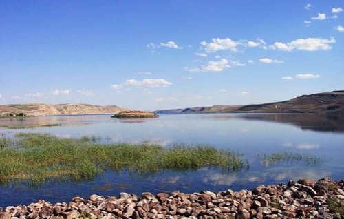
Euphrates River in northern Syria

The photos we post of the Euphrates River are always popular. I suppose this is because of the historic events associated with the river, and because so few people have seen the river. The Euphrates begins in the mountains of eastern Turkey (ancient Urartu/Ararat), flows south through Syria and Iraq before ending at the Persian Gulf.

Some of the great Bible characters are associated with the River, even when it is not named. We can be sure that Abraham crossed the Euphrates when he left Haran and headed south to Canaan (Genesis 11:32 – 12:1-9). I like the account of Jacob fleeing from Laban.

He left with all he owned. He quickly crossed the Euphrates River and headed for the hill country of Gilead. (Genesis 31:21 NET)

This photo was made in northern Syria, northeast of Aleppo in 2002. Here the river is wide because of a series of dams built by the Syrians. This can not be far from the place where the biblical patriarchs crossed the river.

The Euphrates River in northern Syria. Photo by Ferrell Jenkins.

The Euphrates River in northern Syria. Photo by Ferrell Jenkins.

Herod built a hippodrome at Caesarea Maritima

Herod the Great built a hippodrome along the coast at Caesarea Maritima in 10 B.C. to celebrate the opening of the city. In the second century A.D. the south side of the hippodrome was reconstructed as an amphitheater to be used for gladiatorial contests. New sections with beautiful frescoes have been uncovered.

This metal sculpture has been erected on the north end of the hippodrome along the beautiful Mediterranean.

View in the hippodrome at Caesarea Maritima. Photo by Ferrell Jenkins.

View from the hippodrome at Caesarea Maritima. Photo by Ferrell Jenkins.

The theater we showed in the previous post is on the south end of the hippodrome. The harbor built by Herod the Great is a little to the north of the hippodrome. The apostle Paul was in prison at Caesarea for two years between A.D. 58 and 60 (Acts 23:23 – 26:32).

We discussed Paul’s possible use of the charioteer in Philippians 3:12-14 here.

New paintings of the hippodrome mosaics. Photo by Ferrell Jenkins.

New paintings of the hippodrome frescoes. Photo by Ferrell Jenkins.

Caesarea Maritima

Caesarea Maritima was a first century Roman capital and seaport. The gospel was first preached to the Gentiles here when Peter came from Joppa to Caesarea to tell Cornelius words by which he could be saved (Acts 10, 11).

Herod the Great built a city on the site of Strato’s Tower and named it Caesarea in honor of Caesar Augustus. It became a center of Roman provincial government in Judea. The city had a harbor and was located on the main caravan route between Tyre and Egypt. This city is called Caesarea Maritima (on the sea) to distinguish it from Caesarea Philippi.

The theater, now restored, was built originally by Herod the Great. Others added to and modified the theater in later centuries. The seating capacity is about 4000. Between the theater and the Mediterranean Sea is an open area in which numerous building fragments are displayed in a park-like environment. In the foreground we see the base of a column.

The restored theater at Caesarea Maritima. Photo by Ferrell Jenkins.

The restored theater at Caesarea Maritima. Photo by Ferrell Jenkins.

An inscription with the name of Pontius Pilate, the Roman procurator, was found during the reconstruction of the theater June 15, 1961.

The Apostle Paul used the harbor at Caesarea several times. He was imprisoned here for two years before departing for Rome (Acts 24:27; 27:1).

Underground quarry discovered in Jordan Valley

Israeli papers are reporting the discovery of an underground quarry in the Jordan Valley. Prof. Adam Zertal and a team of archaeologists from the University of Haifa are working on the hypothesis that this is the site of biblical Gilgal.
The biblical account in Joshua reads,
Now the people came up from the Jordan on the tenth of the first month and camped at Gilgal on the eastern edge of Jericho. Those twelve stones which they had taken from the Jordan, Joshua set up at Gilgal. (Joshua 4:19-20 NAU)
The report in Ha’aretz gives more information about the discovery.

A spectacular underground quarry has recently been discovered in the Jordan Valley north of Jericho, which archaeologists believe may have marked a biblical site sacred to ancient Christians.

The large cave was discovered by Prof. Adam Zertal and a team from the University of Haifa which has been conducting a survey of the region since 1978. “When we reached the entrance to the cave, two Bedouin approached us and warned us not to go in, because it was cursed and inhabited by wolves and hyenas,” Zertal said yesterday from the site.

They entered anyway, discovering a ceiling supported by 22 gigantic columns on which various symbols were carved, including 31 crosses, a possible wheel of the Zodiac and a Roman legionary symbol. The columns also had niches for the placement of oil lamps and holes that apparently served as hitching posts.

Jordan Valley cave. Photo courtesy of University of Haifa.

Jordan Valley cave. Photo courtesy of University of Haifa.

The Ha’aretz article continues,

Zertal says their working theory is that the site is Galgala, biblical Gilgal, mentioned on the sixth-century Madaba mosaic map. The cave, buried 10 meters underground, is about 100 meters long, 40 meters wide and 4 meters high, is the largest artificial cave so far discovered in Israel.

Potsherds found in the cave and the carvings on the columns led Zertal to date the first quarrying of the cave to around the beginning of the Common Era. It was used mainly as a quarry for 400 to 500 years, “but other finds give the impression it was used for other purposes, perhaps a monastery or even a hiding place,” Zertal said.

Zertal said scholars wondered why people would dig a quarry underground considering the effort needed just to pull the stones out of the ground.

A possible answer may be in the famous Madaba Map of ancient Palestine, found in Jordan. In it, a place named Galgala is marked and an accompanying Greek word meaning “12 stones.” The map also depicts a church near the site. Archaeologists say they have found two ancient churches near the cave.

According to Zertal, scholars had always assumed that “12 stones” referred to the biblical story of the 12 stones the Israelites set up at Gilgal after they crossed the Jordan. However, the discovery of the quarried cave may mean the reference was to a quarry established where the Byzantines identified Gilgal. Zertal explains that in antiquity sanctuaries were built out of stones from sacred places.

If the Byzantines identified the site as biblical Gilgal, it would have been considered sacred and quarrying would have remained underground to preserve it.

Here is a photo of a portion of the Madaba Map that I made last year.

Madaba Map showing Gilgal, Jericho, Jordan River. Photo by Ferrell Jenkins.

Madaba Map showing Gilgal, Jericho, Jordan River. Photo by Ferrell Jenkins.

This portion of the map shows the northern end of the Dead Sea and the Jordan River. You will notice fish turning around when they reach the Dead Sea. I think everyone can make out the city of palm trees, IERIXW (Jericho, Deuteronomy 34:3). To the north of Jericho, and a little east toward the river, is the site of Gilgal.

The inscription reads “Galgala, also the twelve stones.” Below the inscription is a small church with its entrance hidden by a long structure with 12 white spots on it (two rows of six). The Madaba map is dated to about A.D. 560 to 565. You may read more about the Madaba Mosaic Map here.

HT: Joseph I. Lauer

UPDATE: A short video showing the cave and featuring Dr. Zertal is available from BBC here.

Paul, Silas, and Timothy pass through Amphipolis

Amphipolis was situated about 30 miles west of Philippi on the Via Egnatia. Luke remained at Philippi while Paul, Silas and Timothy continued to Thessalonica. There is no indication of any preaching done in Amphipolis and Appollonia. In fact, the reference to the city barely attracts notice.

Now when they had passed through Amphipolis and Apollonia, they came to Thessalonica, where there was a synagogue of the Jews. (Act 17:1 ESV)

The River Strymon runs past Amphipolis and continues for about 3 1/2 miles south where it flows into the Aegean Sea. The photo of the River Strymon below was made in the late afternoon against the sun, but I like the effect.

The River Strymon at Amphipolis. Photo by Ferrell Jenkins.

The River Strymon at Amphipolis. Photo by Ferrell Jenkins.

K. L. McKay, in an article in The New Bible Dictionary, describes the city briefly:

Prized by the Athenians and Macedonians as the key both to the gold, silver and timber of Mt Pangaeus and also to the control of the Dardanelles, it became under the Romans a free town and the capital of the first district of Macedonia. Amphipolis is about 50 km WSW of Philippi on the Via Egnatia, a great Roman highway, and Paul passed through it on his way to Thessalonica (Acts 17:1).

The city is somewhat difficult to reach and there is little is to be seen.

Amphipolis Archaeological Site. Photo by Ferrell Jenkins.

Amphipolis Archaeological Site. Photo by Ferrell Jenkins.

Neapolis was the port of Philippi

During his second journey, while at Troas, Paul saw a vision of a man of Macedonia. Luke gives the following record of the vision and of the subsequent action of the apostle.

A vision appeared to Paul in the night: a man of Macedonia was standing and appealing to him, and saying, “Come over to Macedonia and help us.” When he had seen the vision, immediately we sought to go into Macedonia, concluding that God had called us to preach the gospel to them. (Acts 16:9-10)

Paul and his companions, including Luke, landed at Neapolis (modern Kavalla). The text indicates that the real goal of their mission was to reach the Roman colony of Philippi. Philippi was about 10 miles away, and could be reached by traveling the famous Via Egnatia across Mount Symbolum. Neapolis had been founded in the 7th century B.C. and served as the port of Philippi. Here is a photo of the modern port at Kavalla in northern Greece.

The harbor of Kavalla, Greece, known as Neapolis at the time of Paul. Photo by Ferrell Jenkins.

The harbor of Kavalla (biblical Neapolis), Greece. Photo by Ferrell Jenkins.

Luke uses his words sparingly.

So putting out to sea from Troas, we ran a straight course to Samothrace, and on the day following to Neapolis. (Act 16:11)

Paul and his companions sailed from Philippi (the port of Neapolis) to Troas on the return from the third journey (Acts 20:3-6.

Cappadocia was home to early Christians

John Freely describes Cappadocia in these words:

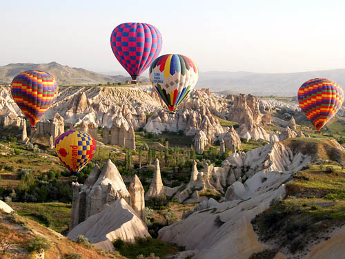
“Most of this part of Cappadocia is covered with a deep layer of tufa, a soft stone of solidified mud, ash and lava which once poured down from the now extinct volcanoes on Hasan Dagi and Ericiyes Dagi, the two great mountain peaks of Cappadocia. In the eons since then the rivers of the region have scoured canyons, gorges, valleys and gulleys through the soft and porous stone, and the elements have eroded it into fantastic crags, folds, turrets, pyramids, spires, needles, stalagmites, and cones, creating a vast outdoor display of stone sculptures in an incredible variety of shapes and colours” (The Companion Guide to Turkey, 238).

Devout Jews from Cappadocia were present in Jerusalem on Pentecost (Acts 2:9). Peter=s letters were addressed to Christians living in Cappadocia (1 Pet. 1:1). In the centuries after New Testament times many Christians settled in this volcanic region of perhaps 50,000 cones.

Gliding gently over Cappadocia. Photo by Ferrell Jenkins.

Gliding gently over Cappadocia. Photo by Ferrell Jenkins.

The best way to enjoy the Cappadocian landscape is by taking a hot air balloon early in the morning. Drifting gently over the landscape is a unique experience.

Todd Bolen calls attention to a nice photo gallery of Cappadocia in the Los Angeles Times here.

The Apostle Paul came to Philippi

The Apostle Paul came to Philippi on his second preaching journey. Luke accurately describes the city with these words:

So putting out to sea from Troas, we ran a straight course to Samothrace, and on the day following to Neapolis; and from there to Philippi, which is a leading city of the district of Macedonia, a Roman colony; and we were staying in this city for some days. (Act 16:11-12 NAU)

The photo below shows ruins of the theater which was cut into the mountain side. It was built in the days of Philip II in the 4th century B.C. During renovations in the second and third century A.D. arrangements were made for gladiatorial contests.

The theater at Philippi. Built in 4th century B.C. Photo by Ferrell Jenkins.

The theater at Philippi. Built in 4th century B.C. Photo by Ferrell Jenkins.

According to Fant and Reddish,

the theater was modified for gladiatorial contests. The first three or four rows of seats were removed, protective walls were added to keep the animals from the audience, new rows of seats were added on the upper part of the theater, and, in the 3rd century, an underground tunnel was constructed underneath the orchestra for the purpose of bringing in the wild animals. (A Guide to Biblical Sites in Greece and Turkey, 109-110)