Monthly Archives: November 2016

Roman inscription of formerly unknown governor of Judea discovered

Phillippe Bohstrom has written a fascinating and informative article about the discovery of a Roman inscription mentioning the province of Judea and a previously unknown Roman governor.

This Marcus Paccius ruled Judea before the Bar Kochba Revolt (about A.D. 135).

There were nearly 20 Roman prefects or governors during the first century A.D., but we learn only the names of Pontius Pilate (the trial of Jesus), Felix (Acts 23-24), and Festus (Acts 25-26) in the New Testament.

Haifa University underwater archaeologists found this inscription off the coast of Dor.

The newly found inscription, carved on the stone in Greek, is missing a part, but is thought to have originally read: “The City of Dor honors Marcus Paccius, son of Publius, Silvanus Quintus Coredius Gallus Gargilius Antiquus, governor of the province of Judea, as well as […] of the province of Syria, and patron of the city of Dor.”

The inscription is now on display in the Haifa University Library.

Stone inscription with the name of Marcus Paccius, governor of the province of Judea and Syria. Photo by Jenny Carmel in HaAretz.

Stone inscription with the name of Marcus Paccius, governor of the province of Judea and Syria. Photo by Jenny Carmel in HaAretz.

Read Bohstrom’s article with photos here.

Our photo below shows the area around ancient Dor.

Aerial view of Dor. Photo by Ferrell Jenkins.

Aerial view of Dor. Photo by Ferrell Jenkins.

For a list of Old Testament reference to Dor click here.

Harbor of Pharaoh Cheops reported found on Red Sea

Philippe Bohstrom has a fascinating article this morning in HaAretz about the discovery of a harbor on the Red Sea and an archive of papyri dating to the time of Pharaoh Cheops (about 2500 B.C.).

The oldest known harbor in the world has been discovered by archaeologists diving off the Red Sea site of Wadi el-Jarf. The site was found near a huge archive of papyri – which is also the oldest known to date, and which describe how the harbor was built and used by the great King Cheops to import materials to build his flagship monument, the Great Pyramid of Giza.

The monumental harbor discovered under the waves at Wadi el-Jarf has been dated to 4600 years ago, right in Cheops’ time.

Cheops, also known by his Egyptian name Khufu, reigned from 2580 to 2550 B.C.E. He had the harbor erected 180 kilometers south of Suez, in the foothills of the desert mountains.

Many have been fascinated by the Great Pyramid (or Pyramid of Cheops – or Khufu), dating to about 2500 B.C. Perhaps we are not surprised to learn of this impressive shipping enterprise on the Red Sea.

The Great Pyramid of Pharaoh Cheops (Khufu) at Giza. Photo by Ferrell Jenkins.

The Great Pyramid of Pharaoh Cheops (Khufu) at Giza. Photo by Ferrell Jenkins.

I encourage you to check Bohstrom’s article here with numerous photos and a map to locate the discovery on the Red Sea.

Again, I would remind our readers that the Pyramids of Giza were built long before the time of Abraham, and the later Israelites.

A wadi along the King’s Highway

The King’s Highway is mentioned by name in Numbers 20:17 and 22. As the Israelites made their slow trek toward the promised land (Genesis 12:7; 15:7) they asked permission to go through the land of Edom.

 17 Please let us pass through your land. We will not pass through field or vineyard, or drink water from a well. We will go along the King’s Highway. We will not turn aside to the right hand or to the left until we have passed through your territory.”
18 But Edom said to him, “You shall not pass through, lest I come out with the sword against you.”
19 And the people of Israel said to him, “We will go up by the highway, and if we drink of your water, I and my livestock, then I will pay for it. Let me only pass through on foot, nothing more.”
20 But he said, a”You shall not pass through.” And Edom came out against them with a large army and with a strong force.
21 Thus Edom refused to give Israel passage through his territory, so Israel turned away from him. (Numbers 20:17-21 ESV)

After going around Edom, Israel sent messengers to the Amorites with a request to go through their land.

“Let me pass through your land. We will not turn aside into field or vineyard. We will not drink the water of a well. We will go by the King’s Highway until we have passed through your territory.” (Numbers 21:22 ESV)

Rasmussen suggests that the first reference is to the East-West route from Kadesh Barnea to Edom. He says,

The second reference is possibly to a portion of the N-S Transjordanian route that connects Edom/Arabia with points to the N. (Zondervan Atlas of the Bible, p. 290).

Sihon, the king of the Amorites, went out to fight Israel. According the the biblical account Israel was successful and settled in cities of the Amorites. Reference is made to Heshbon and the Arnon, now known as the Arnon Gorge or Wadi el-Mujib. As a point of reference the Arnon is about 35 miles south of modern Amman, Jordan.

Our photo shows a wadi along the King’s Highway between Heshbon and the Arnon.

A wadi between Madaba and the Arnon Gorge along the King's Highway in transjordan. Photo by Ferrell Jenkins.

A wadi between Heshbon and the Arnon Gorge along the King’s Highway in transjordan. Photo by Ferrell Jenkins.

This photo was made in mid-May. The shepherd finds shade for his sheep, and a place where some water remains. I think the overhanging rock gives us some indication how high the stream gets when it rains. (NB: I wonder if perhaps this water has been brought in by truck for the sheep.)

Thomas Levy reminds us that “Nahal, incidentally, is Hebrew for a dry river bed or valley that flows at most a few times a year. In Arabic, the word is wadi. The two words are used interchangeably in Israel today.” The wadi is similar to the arroyo of the American southwest. (Biblical Archaeology Review, 1990).

Under the jail – a visit to the Kishle

Read The Citadel of Jerusalem here.
Read Views from the Citadel of Jerusalem here.

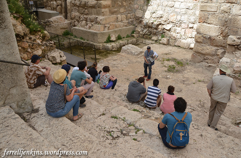
After our visit to see Jerusalem from the roof of the Citadel we made our way through the recently cleared dry moat to the steps and pool from the time of Herod the Great. Our guide, David, used a variety of visual aids to explain where we were and how this might have looked in the time of Herod.

Herodian steps at the Citadel. Photo by Ferrell Jenkins.

Herodian steps at the Citadel. Photo by Ferrell Jenkins.

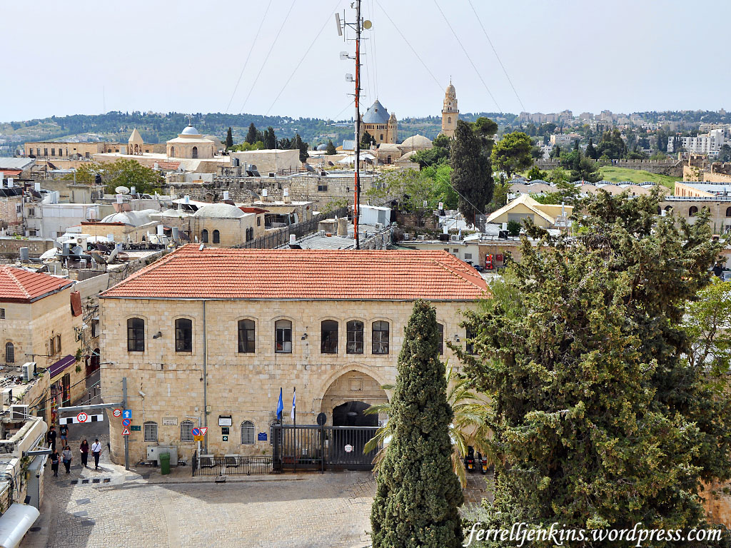
From there David led us to the Kishle (Turkish word for Barracks, and many use it as Prison). The Tower of David web site has this brief explanation of the Kishle.

The site known as the “Kishle” is adjacent to the Citadel and Tower of David Museum complex. The structure was erected in 1834 by Ibrahim Pasha who governed the Land of Israel (Palestine) from Egypt.

When the Ottoman Turks regained the area in 1841, the “Kishle” continued to serve as a military compound. During the period of the British mandate, it was used as a police station and prison where some members of the Jewish underground were also incarcerated.

In an article in Archaeological Diggings, Caroline Shapiro (Nov. 2015) explains how this excavation came about.

The Kishle Building, as it is called, stands adjacent to the Tower of David, the ancient citadel that guards Jerusalem’s Old City at the Jaffa Gate entrance. It was built in 1860 as an Ottoman prison or army barracks. The prison was then used as such by the British during Mandate times and then left desolate until the Tower of David Museum decided to clean up the iron prison cells and create a new wing for the Education Department. It housed members of the pre-State underground, the Irgun, the evidence of which is scratched on the walls.

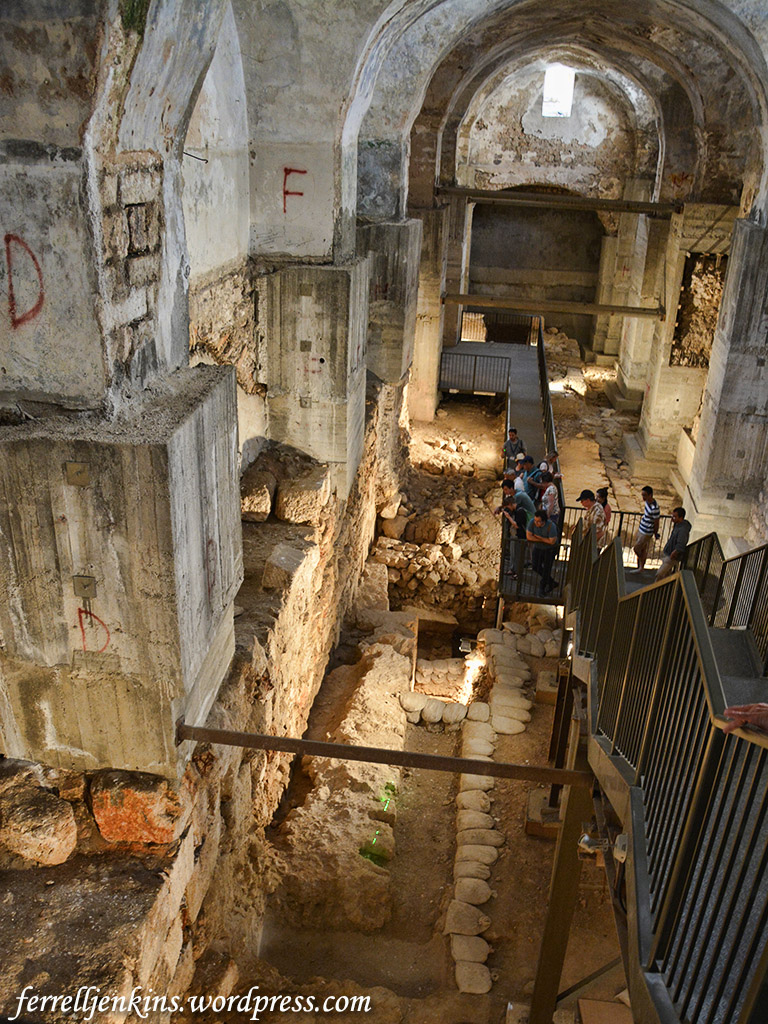
As with any digging in Jerusalem, the clearing up became an excavation and close to 3000 years of history was discovered under its floorboards. The excavations were carried out in 1999–2000 by Amit Re’em, Jerusalem District Archeologist, together with a team from the Israel Antiquities Authority (IAA), but since then the building has been left untouched. Entrance to the Kishle is via the newly opened moat where visitors walk down the impressive Herodian steps leading down into a Hasmonian pool that would have been the lavish pool connected to King Herod’s palace. (These are the only excavations of King Herod’s Palace; huge foundation walls can be seen as well as an impressive water sewage system.)

The whole site has been dug down some 10 metres (33 ft) deep and about 50 metres (165 ft) long to reveal the various strata. With an arched, cross-vaulted Ottoman ceiling, it is a cavernous, silent cathedral of ancient stones that had been untouched by daylight for millennia.

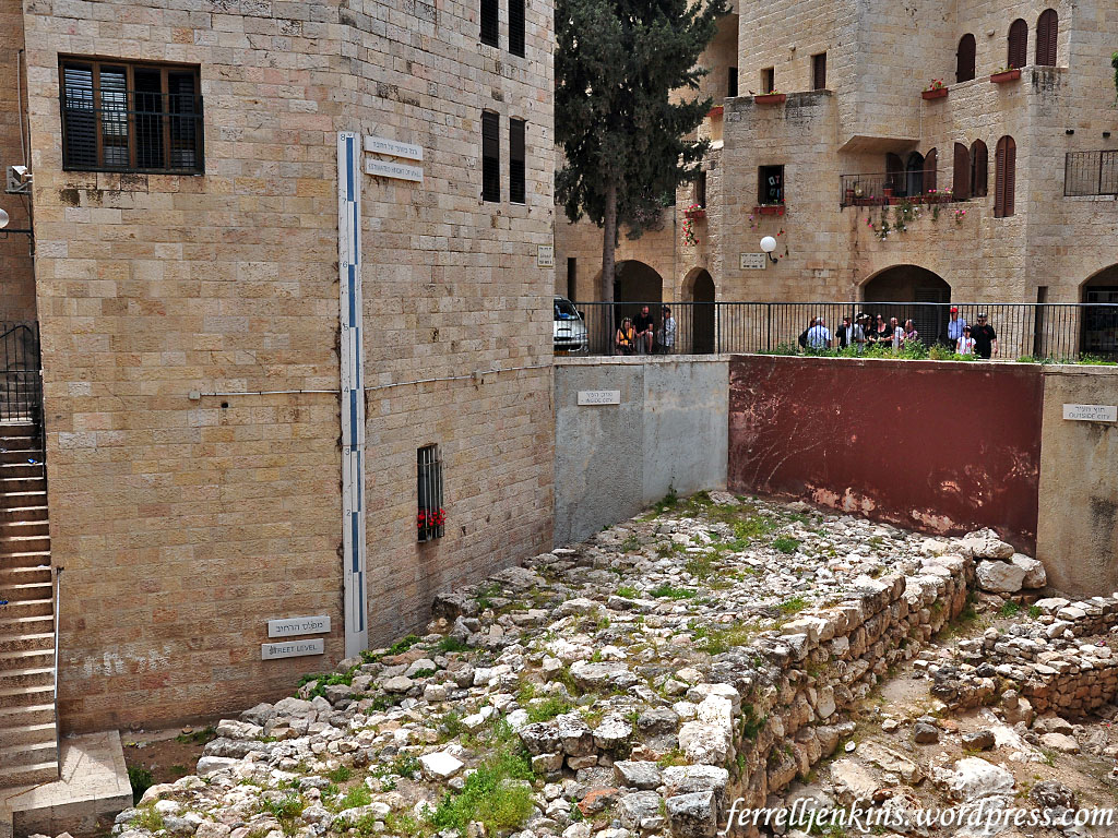
This is our first view of the excavation as we enter the Kishle. I think it is not incorrect to say that ancient ruins will be found anywhere archaeologists dig in Jerusalem. Many sites of importance are in basements.

General view of the archaeological excavation of the Kishle. Photo by Ferrell Jenkins.

General view of the archaeological excavation of the Kishle. Photo by Ferrell Jenkins.

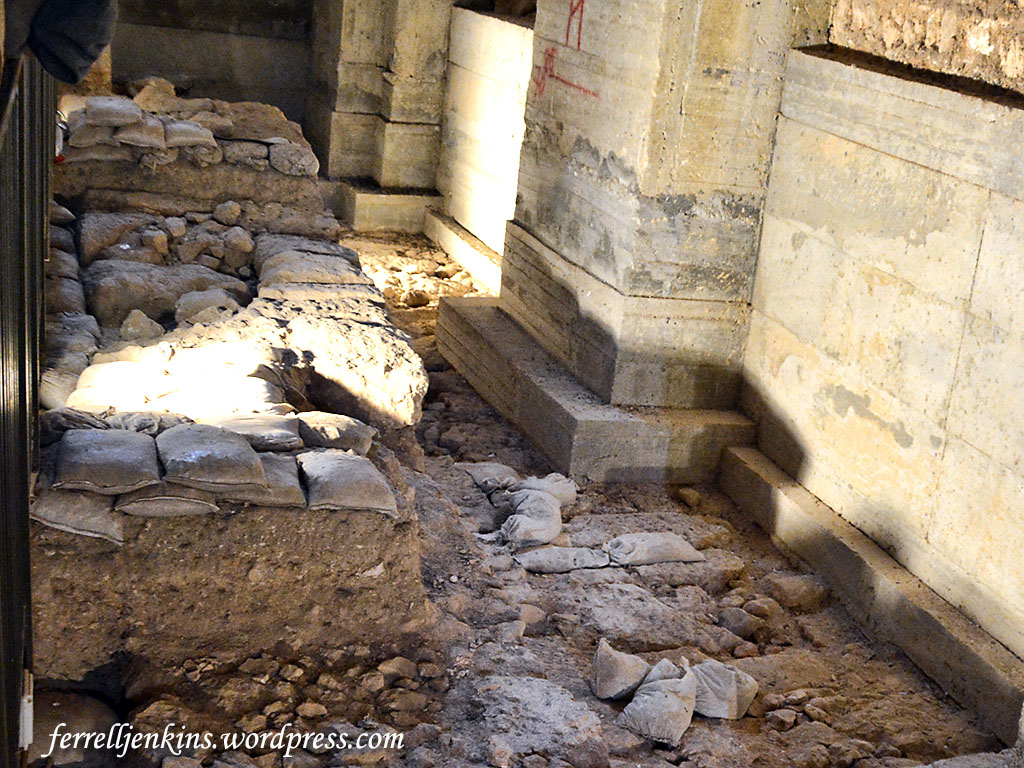
On the far right of the photo above, and below, you will see a stretch of wall from Herod’s palace.

Herodian ruins in the Kishle. Photo by Ferrell Jenkins.

Herodian walls in the Kishle. Photo by Ferrell Jenkins.

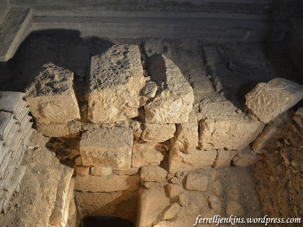
The oldest ruins uncovered during the excavation belong to the 8th century B.C. Perhaps these ruins belong to the time of Hezekiah, King of Judah (729-686 B.C., McKinny).

Ruins from the 8th century B.C., possibly from the time of King Hezekiah. Photo by Ferrell Jenkins.

Ruins from the 8th century B.C., possibly from the time of King Hezekiah. Photo by Ferrell Jenkins.

The Bible describes the work Hezekiah did in response to the Assyrian threat.

He set to work resolutely and built up all the wall that was broken down and raised towers upon it, and outside it he built another wall, and he strengthened the Millo in the city of David. He also made weapons and shields in abundance. (2 Chronicles 32:5 ESV)

The Jewish Quarter Excavations began in 1969 under the direction of Professor Nahman Avigad of Hebrew University. Shapiro says he uncovered a 130-foot long section of stone wall that was 23 feet wide and probably 27 feet high. This is the wall we now call the Broad Wall (Nehemiah 3:8; 12:38).

The Broad Wall excavated by Avigad. Photo by Ferrell Jenkins.

The Broad Wall excavated by Avigad. Photo by Ferrell Jenkins.

The wall within the Kishle is even further to the west, on the top of the western ridge of the Old City.

Re’em Amit, the archaeologists in charge of the dig, argues that this is the palace of Herod the Great, and the location of the Praetorium where the trial of Jesus took place (John 19:13). When I first began to visit Jerusalem we thought the paved area in the Sisters of Zion was the Praetorium. We still visit the site if time permits because it is important in understanding the Roman destruction of Jerusalem, but we now know that the pavement there belongs to the second century A.D.

The Roman Prefect, such as Pilate, would make his residence in Herod’s Palace on his visits to Jerusalem from Caesarea. Herod Antipas, the son of Herod the Great, and Pontius Pilate, the governor [prefect] of Judea were both in Jerusalem at the time of the crucifixion of Jesus (Luke 3:1; 23:4-16). And they were both staying at the best “hotel” in town.

Herod's Palace in the Second Temple model at the Israel Museum. Photo by Ferrell Jenkins.

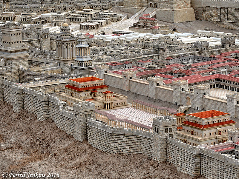
Herod’s Palace in the Second Temple model at the Israel Museum. The Fortress of Antonio is visible at the top/right of the photo. Photo by Ferrell Jenkins.

This is not a new hypothesis, but it does provide new evidence to sustain the view. Shimon Gibson has written extensively on this for several years. Gibson, with an allusion to the writing of Josephus, says,

After the grandeur of the Jewish Temple, Herod’s palace was reportedly the most amazing building complex in Jerusalem. (Final Days of Jesus, 93)

Gibson has a essay on this subject in The World of Jesus and the Early Church, edited by Craig A. Evans. In both of these articles Gibson includes drawings of the area under consideration.

Visiting the Kishle:

The Tower of David is open with English guides Sundays to Thursdays at 11 a.m. At other times one may visit with an audio guide. Adult admission is 40 NIS (about $11).

The guided tour including the Kishle (From Herod’s Palace to British Prison) is available in English on Fridays at 10 a.m. for 45 NIS.

Dates, hours, and admission prices change from time to time. Check the Tower of David web site for current information.


Josephus Elaborates on the Palace

— “ —

176 Now as these towers were themselves on the north side of the wall, the king had a palace inwardly thereto adjoined, which exceeds all my ability to describe it;
177 for it was so very elaborate as to lack no cost nor skill in its construction, but was entirely walled about to the height of thirty cubits, and was adorned with towers at equal distances, and with large bedchambers, that would contain beds for a hundred guests a piece,
178 in which the variety of the stones is not to be expressed; for a large quantity of those who were rare of that kind were collected together. Their roofs were also wonderful, both for the length of the beams, and the splendour of their ornaments.
179 The number of the rooms was also very great, and the variety of the figures that was about them was prodigious; their furniture was complete, and the greatest part of the vessels that were put in them was of silver and gold.
180 There were besides many porticoes, one beyond another, all around, and in each of those porticoes elaborate pillars; yet were all the courts that were exposed to the air everywhere green.
181 There were, moreover, several groves of trees, and long walks through them, with deep canals and cisterns, that in various parts were filled with brazen statues, through which the water ran out. There were with this many dove courts {a} of tame pigeons about the canals.  (Jewish War 5:176-181 or 5.4)

— ” —


Selected Sources:

AP You Tube video featuring Re’em Amit, the Jerusalem District Archaeologist of  the IAA in charge of the excavations of the Kishle. In this video Amit seems to be explaining in English and someone else is translating in another language.

Rasmussen, Carl. Kishle Tour. Photos included.

Rotem, Itay (guide), Tower of David Museum. You Tube.

Shapiro, Caroline. “Doorway to the Past.” Archaeological Diggings, Nov. 2015.

Tower of David web site. Here you will find several links to popular articles about the new excavation.

Ziese, Mark. “The Barracks.”

________.  “What Lies Beneath.”  In both articles Ziese includes some historic photos bringing to mind the use of the Kishle during the British period.

Prof. Yosef Garfinkel at Florida College

Prof. Yosef Garfinkel spoke last evening to an appreciative audience of about 200 students, faculty, and visitors at Florida College, Temple Terrace, Florida. Garfinkel is Yigael Yadin Chair in Archaeology of Israel at the Hebrew University of Jerusalem. His archaeological work has specialized in the Neolothic period, the Chalcolithic period, and the Biblical kingdom of Judah.

Prof. Yosef Garfinkel speaking at Florida College. Photo by Ferrell Jenkins.

Prof. Yosef Garfinkel speaking at Florida College. Photo by Ferrell Jenkins.

This was Prof. Garfinkel’s second time to speak at Florida College. This came about as a result of the archaeological participation of Luke Chandler in two recent projects directed by Garfinkel, the work at Khirbet Qeiyafa and at Tel Lachish. Those of you who follow Chandler’s blog will have some insight into this work. Luke has taken several Florida College faculty members, students, and alumni, to participate in these digs.

Yossi, as he is known to many, spoke of the need for regional research, to examine when “the Kingdom of Judah spread into the Shephelah (south and west of Jerusalem.” Khirbet Qeiyafa, a brief study at Khirbet Arai, and the fourth expedition to Lachish are being used to answer this question.

The archaeologist told how he chose where to begin the fourth Lachish expedition. He chose the northeast corner because of access to water, fertile lands, and a road. He thought this would be an ideal location for a city gate. Indeed, a gate has been located in the area. Through the use of some excellent aerial photographs he showed the location of this recent work.

Earlier in the day Luke and I had lunch with Prof. Garfinkel at a nice local restaurant near Florida College.

Luke Chandler, Yosef Garfinkel, and Ferrell Jenkins.

Luke Chandler, Yosef Garfinkel, and Ferrell Jenkins with a backdrop of Tel Lachish.

I took along some black and white photos and contact prints made at Tel Lachish during the third expedition to Tel Lachish in 1980 when four Florida College faculty members  (Jenkins, Jim Hodges, Phil Roberts, and Harold Tabor) participated in the dig. That project was under the direction of David Ussishkin. I expected Yossi to say, “You haven’t aged much,” when he saw a photo of the four of us with Prof. Ussishkin, but instead he said, “Is that David?” 🙂

Ferrell Jenkins sharing 1980 photos from Lachish with Yossi Garfinkel. Photo by Luke Chandler.

Looking over black and white photos from Lachish made in 1980. Photo by Luke Chandler.

While we were waiting for our lunch we inquired about the progress on a water shaft or tunnel at Tel Lachish. Prof. Garfinkel took a napkin and drew a sketch of the area. We got our lunch but are still waiting patiently for a water system to be revealed at Lachish.

Prof. Garfinkel draws a sketch of the area considered for a water shaft at Tel Lachish.

Prof. Garfinkel draws a sketch of the area where he thought a water shaft might be found at Tel Lachish. Photo by Ferrell Jenkins.

The Biblical Studies faculty shared a dinner with Prof. Garfinkel prior to his 7 p.m. lecture. I was pleased to be included, along with Luke and his family.

There are several posts on this blog about Lachish. Just use the search box to locate them.

Views from the Citadel of Jerusalem

Read our first post about the Citadel of Jerusalem here.

Our main reason for visiting the Citadel on the most recent trip was to visit the newly opened Kishle (Prison). As a part of the tour we took at the Citadel we went to the top of the Tower of David (sometimes called the Tower of Herod) for a view of the Old City of Jerusalem.

The first view looks east. The pyramidal tower in the left foreground belongs to the Christ the Redeemed Lutheran Church. A climb to the top of that tower also provides a wonderful view across the city. In the distance to the right of center is the easily recognizable Mosque of Omar, commonly known as the Dome of the Rock. This is where the Temples of Solomon and Herod stood in Bible times (see Ritmeyer, Jerusalem The Temple Mount, 16-17).

Notice the mountain range to the east. You already know that the Citadel, the highest part of the Old City is more than 2500 feet above sea level, but the mountain range to the east is more than 100 feet higher than the area of the Citadel. There are three towers on the mountain range. On the left (north) is Mount Scopus. To the south you will see the tower of the Augusta Victoria Hospital. Finally, further south is the Tower of the Church of Ascension on the Mount of Olives.

Beyond the Mount of Olives lies the Wilderness of Judea which stretches down to the Jordan Valley and Dead Sea.

This is a view east from the Tower of David. Photo by Ferrell Jenkins.

This is a view east from the Tower of David. Photo by Ferrell Jenkins.

There are many wonderful views from the Citadel Tower. This view is slightly north and provides a look at the two domes of the Church of the Holy Sepulchre. The large dome covers the traditional tomb of Jesus and the smaller dome is nearer to the traditional site of Calvary.

The domes of the Holy Sepulcher, Calvary. Photo by Ferrell Jenkins.

The domes of the Holy Sepulcher from the Tower of David. Photo by Ferrell Jenkins.

In most of these views you may notice the mountains surrounding Jerusalem. This reminds us of the statement of the Psalmist.

As the mountains surround Jerusalem, so the LORD surrounds his people, from this time forth and forevermore. (Psalm 125:2 ESV)

The prominent building in the photo below is the Kishle. This building was used by the Ottomans and the British as a prison. It now serves as the Police Station of the Old City. (Click on the photo for a larger image.)

Notice the small street to the left of the Police Station. That street runs through the heart of the Armenian Quarter of the Old City. In the distance, to the left of the street and photo there is a square building with a dome. That is the roof of the Armenian church, St. James Cathedral. Armenian tradition has it that James the brother of Jesus is buried there.

Notice the pole with several antennas on it. The building in the distance to the right of the pole is the Church of the Dormitian. It is outside the southern wall of the Old City.

Look now to the right side of the photo where you see a grassy knoll and a portion of the southern wall.

Remember that this photo is made from the Tower of David (or Herod) in the Citadel. The area stretching south from the citadel to the southern wall is now known as the Armenian Garden. It is thought by some archaeologist to be the area of Herod’s Palace and the military barracks. This, of course, would make it the area of the Praetorium and the place of Jesus trial. I suggest Shimon Gibson’s “The Trial of Jesus at the Jerusalem Praetorium: New Archaeological Evidence” in Craig A. Evans, Ed., The World of Jesus and the Early Church (Peabody: Hendrickson 2012). The volume on Jerusalem Revealed that we mentioned in the earlier post also has information on this subject.

View north from the Tower of David. The building in the foreground is the prison. Photo by Ferrell Jenkins.

View looking south from the Tower of David. The building in the foreground is the police station. Photo by Ferrell Jenkins.

Some mounted police work out of this police station. If you have ever walked the narrow stepped streets of the Old City you know what this might be the best mode of transportation for the police officers.

Mounted police in front of the prison. Photo by Ferrell Jenkins.

Mounted police in front of the prison. Photo by Ferrell Jenkins.

We will close with an aerial view of the Armenian Quarter of the Old City of Jerusalem. The Citadel can be seen in the upper right quarter of the photo.

Aerial view of the Armenian Quarter. The area marked in yellow is the area of Herod's Palace. Photo by Ferrell

Aerial view of the Armenian Quarter. The area marked in yellow is the area of Herod’s Palace. Photo by Ferrell Jenkins.

In the next photo I have marked the Citadel and the area south to the southern wall of the Old City. This view is from the southeast to the northwest.

Jerusalem Aerial

Aerial view of the Armenian Quarter. The area marked in yellow is the area of Herod’s Palace. Photo by Ferrell

The area of Herod’s Palace is thought to have extended east of (right) the boundary I have drawn, but the buildings there make it impossible to carry out further excavations.

In the next post on the Citadel we plan to take you to see the Kishle excavations.