
Subscribe to continue reading
Subscribe to get access to the rest of this post and other subscriber-only content.

Subscribe to get access to the rest of this post and other subscriber-only content.
Comments Off on Conversions at Corinth in the mid first century A.D.
Posted in Apostle Paul, Bible Lands, Bible Places, Bible Study, Biblical Studies, New Testament, Photography, Travel
Tagged Apostle Paul, Photography, Roman Empire, Travel
If we consider the Gospel of John a sort of “Day Planner” for Jesus, we have nearly complete activity recorded for two weeks of the earthly ministry of Jesus. The first is in John 1:19—2:11 where activity for six of the seven days is recorded. I think the omitted day is the sabbath.
The next nearly complete week is the last week, leading up to the resurrection. John gives more attention to the last week than any other Gospel. Even here we have activities for only six of eight days. This section begins in John 12:1 and continues into John 20. Here is the way I have reconstructed it. Where John does not record the activity I have omitted the scripture reference.
It should be noted that the appearance before Annas and Caiaphas were the Jewish (Religious) trials. The appearance before Pilate [and Herod Antipas] were the Roman (Civil) trials.
John does not record the pronouncement of woes on the religious leaders, the institution of the Lord’s Supper, and the account of the agony in the Garden of Gethsemane.
With this sparse attention given to two weeks, no wonder John says,
Now there are also many other things that Jesus did. Were every one of them to be written, I suppose that the world itself could not contain the books that would be written. (John 21:25 ESV)
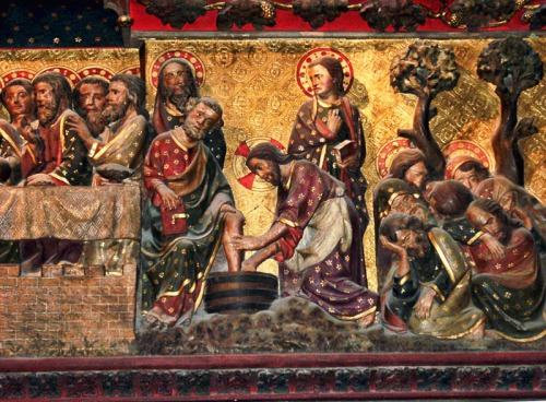
There is a medieval wood carving of the last week of Jesus in Notre Dame (Paris). In this photo you see the representation of the last supper, the washing of the disciples’ feet, and the agony in Gethsemane. (Sorry, this was made more than a decade ago and I don’t have a hi-res photo.) I do not know if this was destroyed in the fire.
Posted in Bible Study
Tagged Bible, Christianity, faith, Israel, Jerusalem, Jesus, Jesus Christ, Roman Empire
Cornelius, a Roman centurion, was the first Gentile convert to the faith. He was stationed at Caesarea on the Mediterranean coast at the time when the apostle Peter was actively working in the spread of the Gospel.
A centurion in the Roman army normally had charge of 100 men (= to an Army captain). A regular cohort was one tenth of a legion and had a paper strength of 600 men. An auxiliary cohort was usually comprised of 1,000 men. Cornelius was of the Italian cohort. There is inscriptional evidence for the “Italian cohort” from Syria (See Bruce, 215).
When Paul set sail from Caesarea for Rome he was accompanied by a centurion of the Augustan cohort named Julius (Acts 27:1). All of the centurions mentioned in the New Testament make favorable impressions. This was not true of soldiers generally (Luke 3: 14). Note these examples:
The centurion at the crucifixion of Jesus (Luke 23:47).
F. F. Bruce (The Book of Acts, NICNT) cites Polybius (History vi.24) saying,
“Centurions are required not to be bold and adventurous so much as good leaders, of steady and prudent mind not prone to take the offensive or start fighting wantonly, but able when overwhelmed and hard-pressed to stand fast and die at their post.”
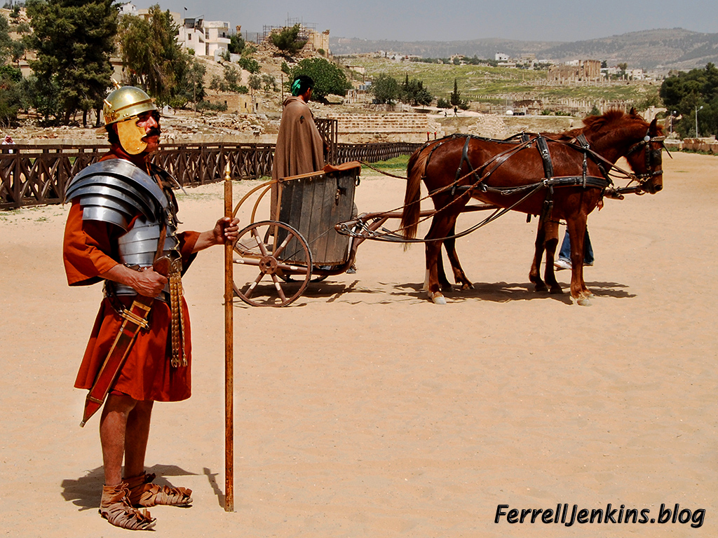
There is a wonderful performance in the early second century A.D. hippodrome at Jerash, Jordan. The RACE show (Roman Army Chariot Experience) shows actors dressed as Roman soldiers performing various activities of the early soldiers. Our photo shows a Roman centurion from that show.
Posted in Apostle Paul, Bible Places, Bible Study, Book of Acts, Israel, New Testament, Photography, Travel
Tagged Apostle Paul, Apostle Peter, Ministry of Jesus, Photography, Roman Empire, Travel
The New Testament site of Antipatris was known as Aphek in Old Testament times. It is the place where the Philistines were encamped when they took the ark of the covenant from the Israelites who had camped at nearby Ebenezer (1 Samuel 4:1).
Antipatris was built by Herod the Great and named in honor of his father Antipater.
Because Aphek/Antipatris sat on a major south-north and west-east routes, it was dominated by many nations. The dominant feature of the site today is the Turkish fort. Inside are the excavated ruins of buildings from Canaanite to Herodian/Roman times.
Aphek/Antipatris is known by the modern name Ras el-Ain because it is located at the source of the Yarkon River which flows a few miles into the Mediterranean.
When a plot was raised against Paul while he was in the Fortress of Antonia in Jerusalem, he was sent by night to Antipatris. The next day he was escorted to Caesarea Maritima. Luke records the event,
So the soldiers, according to their instructions, took Paul and brought him by night to Antipatris. And on the next day they returned to the barracks, letting the horsemen go on with him. When they had come to Caesarea and delivered the letter to the governor, they presented Paul also before him. (Acts 23:31-33 ESV)
A small portion of the Roman cardo, the main East-West road has been uncovered.
From Jerusalem to Antipatris is about 30 miles. From there to Caesarea Maritima is an additional 27 miles.
Paul would remain in custody at Caesarea Maritima for two years. We probably realize that the wheels of power often turn slowly.
The map below is used courtesy of BibleMapper blog.

Courtesy of BibleMapper blog.
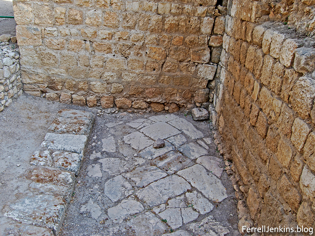
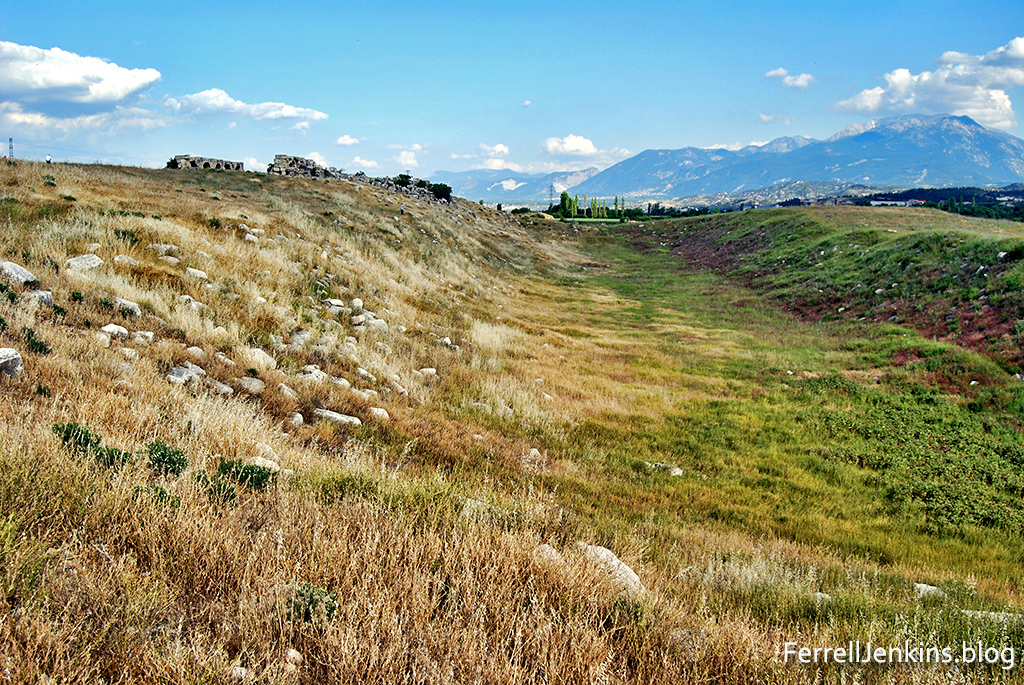
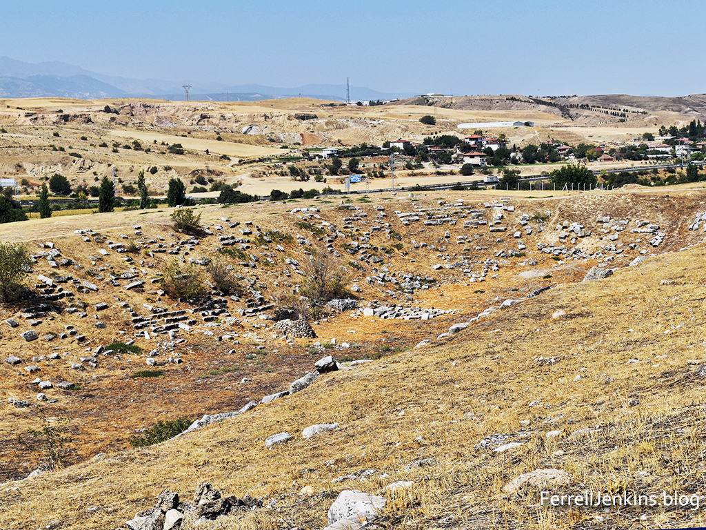
Hurriyet Daily News, a Turkish newspaper, reported a few years ago here on plans to reconstruct the ancient stadium in Laodicea. Laodicea is known to Bible students from the book of Revelation (1:11; 3:14-22), and from Paul’s epistle to the Colossians.
For I bear him [Epaphras] witness that he has worked hard for you and for those in Laodicea and in Hierapolis. Luke the beloved physician greets you, as does Demas. Give my greetings to the brothers at Laodicea, and to Nympha and the church in her house. And when this letter has been read among you, have it also read in the church of the Laodiceans; and see that you also read the letter from Laodicea. (Colossians 4:13-16 ESV)
Laodicea is located about 100 miles east of Ephesus, five miles from the modern Turkish town of Denizli, and near the popular resort of Pamukkale.
When I first began traveling to visit the sites of the Seven Churches of the book of Revelation, all we could see at Laodicea was the form of the stadium and ruins of a nymphaeum (a fountain house). If we walked across the mound to the north we could see the location of two theaters. That was about it.
In recent years tourists have seen many new excavations and reconstructions on the north side of the tell, but few walked through the weeds to get to the stadium.
Originally the stadium was an enclosed structure used for gladiatorial games. An inscription tells that a wealthy family dedicated it to Emperor Vespasian (A.D. 69-79) and Emperor Titus (A.D. 79-81). It is said to be the biggest stadium in Anatolia.
Vespasian and Titus are known for their war with the Jews beginning in A.D. 66, and the destruction of Jerusalem in A.D. 70.
Through the years of leading tours to the Bible lands I have observed that some travelers see the land at a particular time of the year and conclude that the land looks like that all years. Big mistake.
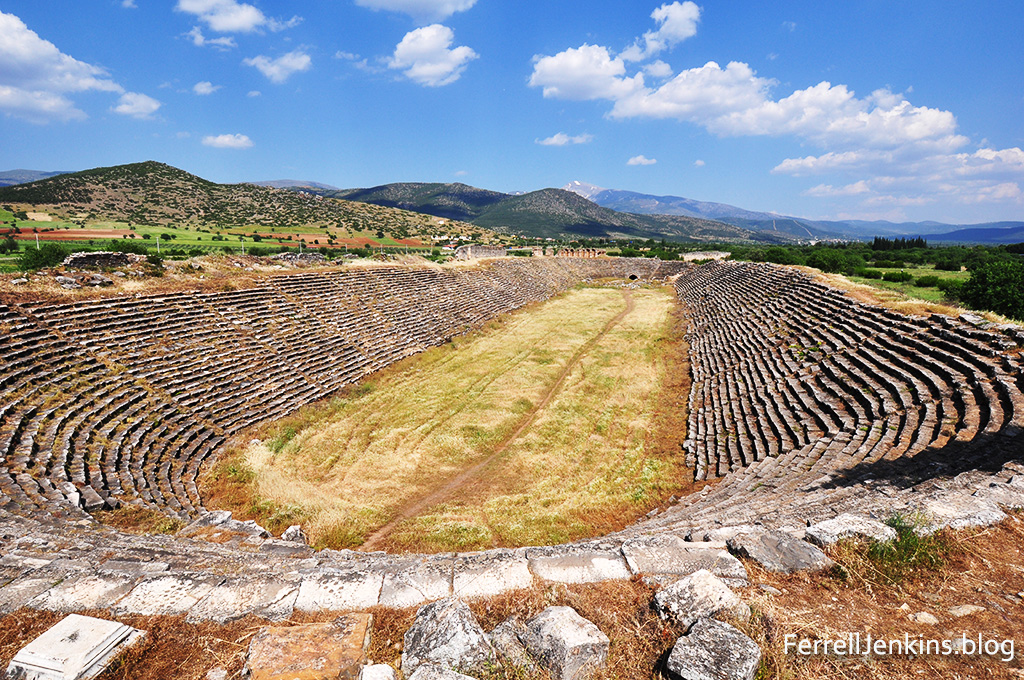
Aphrodisias, located in southwest Turkey, was an ancient city of Caria in Asia Minor. It is not mentioned in the Bible, but is close to the cities of Laodicea, Hierapolis and Colossae. Robert F. Tannenbaum, an ancient historian, describes the location of the city this way:
A quiet, fertile valley folded into the Mediterranean hills, clear streams, tall poplars, ancient ruins more than 1,400 years old—a picture of pastoral quiet. (Biblical Archaeology Review, Sept/Oct 1986)

The map above is cropped from the set of BibleMapper maps now available at
https://biblemapper.com/blog//. Aphrodisias is clearly marked.
The site has been excavated since 1966, beginning under the direction of Kenan Erim of New York University. Marble was readily available at a nearby quarry and the excavation has brought to light a multitude of marble inscriptions and statues from the Roman period including a statue of the Emperor Domitian. Buildings include a theater, an agora, a bath, temples, and a well-preserved stadium.
Louw-Nida describes a stadium as an “open, oval area (frequently including a racetrack) around which was built an enclosed series of tiers of seats for those who came to watch the spectacles – arena, stadium.” When Paul spoke of running the race in 1 Corinthians 9:24, he used the Greek term stadion. The term was also used as a measure of distance and is found in John 6:19. It was about one-eighth of a Roman mile. Most large Greek and Roman cities had a stadium. The figure of the stadium is in mind in Hebrews 12:1-2, where a host of witnesses watch as we run the race.
Therefore, since we are surrounded by so great a cloud of witnesses, let us also lay aside every weight, and sin which clings so closely, and let us run with endurance the race that is set before us,
2 looking to Jesus, the founder and perfecter of our faith, who for the joy that was set before him endured the cross, despising the shame, and is seated at the right hand of the throne of God.
(Hebrews 12:1-2 ESV)
The stadium at Aphrodisias is the best preserved I have seen and I wanted to share with you the photo I made in 2012. Picture yourself in the stadium.
Posted in Bible Lands, Bible Places, Bible Study, Biblical Studies, Culture, New Testament, Travel, Turkey
Tagged Apostle Paul, Roman Empire
Less than 3 months ago we reported here on the discovery of a second century Roman road uncovered in the vicinity of Beit Shemesh and the Elah Valley. Recently we came down to the area from Hwy. 60 south of Bethlehem on Hwy. 375. The information in the IAA press release indicated that the newly discovered road was near Beit Natif (Netiv), but we saw no indication of it. We went into the village of Beit Netiv and a gentleman pointed us back toward Bethlehem and told us that we would find a road on the left where he thought some work was being done.
Following the kind gentleman’s instruction we turned successively into two roads, but neither led us to the Roman road. Finally I checked this blog and downloaded the IAA Press Release for a phone number and called the IAA office. A lady there said she did not know where the road was located but that we should give her 10 minutes and then call back for the answer. When we called back there was no answer. Hmm.
Deciding to retrace our steps we headed back toward Bethlehem again. This time we had a good view to the left of the highway and saw the Roman road. The road did not come down to the modern highway 375. How would we get to it?
We had passed the satellite antennas and the Etziyona Junction of Hwy. 367 going to Neve Micha’el when we saw the Roman road on the hillside coming down from the hill on which Ramat Beit Shemesh is built. Then we realized that the Work Area, which seems to be for road work, was the only place we could turn in. This time there was not as much equipment in the area and we saw an opening leading toward the fields and the road. We took that road and found parking out of the way of any workmen that might need to come through. Note Hwy. 3855 coming down to Hwy. 375. The Work Area is a short distance from the junction.
I am hopeful that the annotations on this previously published aerial photo will be helpful to anyone hoping to visit this road.

Aerial photograph of the road in the lower right corner of the photo. Photographic credit: the Griffin Aerial Photography Co., courtesy IAA. Annotations added.
In the next photo you see the difference that a few months make in the fields. The satellite station and the turn to Hwy. 367 is a short distance to the right of this photo.

Roman road looking down to Highway 375. Photo by Ferrell Jenkins.
The Israel National Trail crosses the new road. The white, blue, and orange stripes mark this trail all over the country.
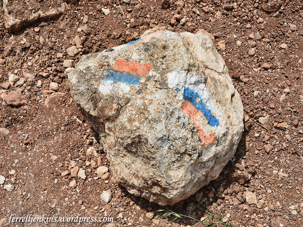
The Israel National Trail crosses the new road. The white, blue, and orange stripes mark this trail all over the country. Photo by Ferrell Jenkins.
In the short time we were there we saw two young men and three young ladies cross the 1800-year-old Roman road. The Trail continues up the field road and between the trees on the right.

Three young ladies take a break from hiking while standing on the Roman Road. Photo by Ferrell Jenkins.
I decided to take a little break on the curb of the road which is thought by the archaeologists to have provided a way from an ancient village to connect with the Emperor’s highway which comes down from the mountain ridge of Judea.
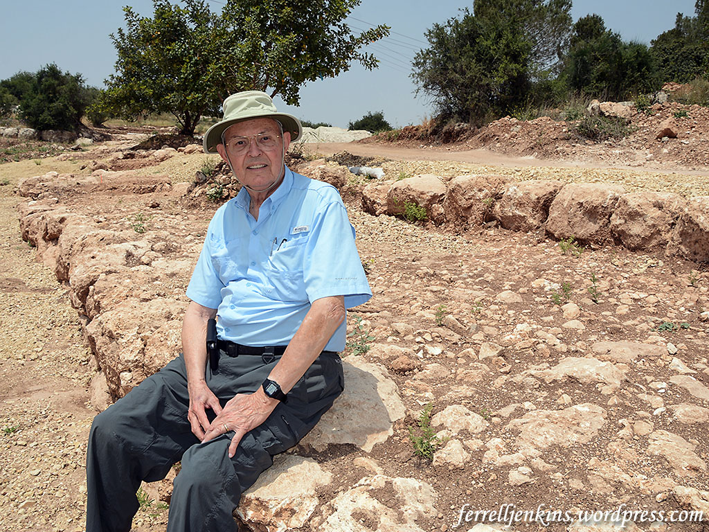
Ferrell Jenkins waiting on the curb of the Roman Road as it approaches the location of the Emperor’s Highway. Photo by Leon Mauldin.
The Roman Roads of which we find remnants in Israel today date mostly from the late first or early second century A.D. Israel Roll, who has written much on the subject, says,
The Roman road network in Judaea was not constructed at once, but evolved gradually from the First Revolt onward. Until then the Roman administration used roads that had been built during or prior to the reign of Herod. Our knowledge of those roads is scanty, and is based essentially on isolated written sources—mainly in the New Testament and Josephus. These sources do not
mention anything relating to road construction or maintenance before the beginning of the rebellion in 66 C.E. (Israel Roll, “The Roman Road System in Judaea,” Jerusalem Cathedra 3 (1983): 138.)
James F. Strange, in discussing the roads in Roman Galilee, says,
Paved, Roman imperial roads mostly date from the second century CE. They are broad, hard-surfaced, featuring curb stones, sometimes center stones, and even milestones. Such is not the case for village ways or paths.
Strange concludes his study with this statement:
One can readily see that a dense network of trails, tracks, and footpaths probably covered Roman-period Galilee. The network was the imprint of everyday travel in the Galilee for trade, some of it from cities like Sepphoris or Tiberias and some from villages like Nazareth or Shikhin. Part of the network is international, but the majority is formed of local trails. Some have wondered how Jesus gathered crowds, but it is simpler to imagine given such a solid web of footpaths, ways, and roads. (James F. Strange. “The Galilean Road System.” Galilee in the Late Second Temple and Mishnaic Periods. Ed. David A. Fiensy and James Riley Strange. Minneapolis: Fortress, 2014.)
The Roman road was high on my wish list for this recent personal study trip, and I am glad to have seen it with my own eyes and walked on it with my own feet. Trust you will enjoy these photos until you have the opportunity to visit the road.
Update: Reader Barry Britnell pointed out that the road I identified as Hwy. 375 (before the curve) is actually Hwy. 3855. Many thanks for the correction. I think I have made the corrections in the text for those who may be serious about locating the Roman Road.
Posted in Archaeology, Bible Lands, Bible Places, Bible Study, Israel, Travel
Tagged Roman Empire
Tuesday brought another press release from the Israel Antiquities Authority. The headline of the release calls this “a 2,000 Year Old Road,” but the text states that its’ construction is dated to the time of the Roman Emperor Hadrian (A.D. 117-138).

Aerial photographs of the road in the lower right corner of the photo. Photographic credit: the Griffin Aerial Photography Company, courtesy of the Israel Antiquities Authority.
The Press Release follows.
A wide and impressive 2,000 year old road dating to the Roman period, in an extraordinary state of preservation, was revealed last February in archaeological excavations of the Israel Antiquities Authority near Highway 375. The excavation was conducted prior to laying a water pipeline to Jerusalem, at the initiative of, the Bet Shemesh water corporation “Mei Shemesh”. Students from “Ulpanat Amit Noga” in Ramat Bet Shemesh volunteered to participate in the dig.

The excavation director, Irina Zilberbod, at the site. Photographic credit: the Griffin Aerial Photography Company, courtesy of the Israel Antiquities Authority.
According to Irina Zilberbod, director of the excavation on behalf of the Israel Antiquities Authority, “The road that we discovered, which 2,000 years ago passed along a route similar to Highway 375 today, was up to 6 meters wide, continued for a distance of approximately 1.5 kilometers, and was apparently meant to link the Roman settlement that existed in the vicinity of Beit Natif with the main highway known as the “Emperor’s Road”. That road was in fact a main artery that connected the large settlements of Eleutheropolis (Bet Guvrin) and Jerusalem. The construction of the Emperor’s Road is thought to have taken place at the time of Emperor Hadrian’s visit to the country, circa 130 CE, or slightly thereafter, during the suppression of the Bar Kokhba revolt in 132-135 CE. The presence of a milestone (a stone marking distances) bearing the name of the emperor Hadrian which was discovered in the past close to the road reinforces this hypothesis”.
Coins were discovered between the pavement stones: a coin from Year 2 of the Great Revolt (67 CE), a coin from the Umayyad period, a coin of the prefect of Judea, Pontius Pilate, dating to 29 CE and a coin of Agrippa I from 41 CE that was minted in Jerusalem.

The ancient coins that were discovered in the excavation. Photographic credit: Clara Amit, courtesy of the Israel Antiquities Authority. The coin at the top is from the Umayyad period (A.D. 661-750). Bottom row (left to right): Herod Agrippa I – A.D. 41; Pontius Pilate – A.D. 29; Jewish Revolt – year 2 – A.D. 67-68.
Up until 2,000 years ago most of the roads in the country were actually improvised trails. However during the Roman period, as a result of military and other campaigns, the national and international road network started to be developed in an unprecedented manner. The Roman government was well aware of the importance of the roads for the proper running of the empire. From the main roads, such as the “Emperor’s Road”, there were secondary routes that led to the settlements where all of the agricultural products were grown. The grain, oil and wine, which constituted the main dietary basis at the time, where transported along the secondary routes from the surroundings villages and then by way of the main roads to the large markets in Israel and even abroad.
According to Amit Shadman, the Israel Antiquities Authority district archaeologist for Judah, “The ancient road passed close to the Israel National Trail and we believe that it will spark interest among the hikers. The Israel Antiquities Authority and Mei Shemesh Corporation have agreed that the road will be conserved in situ, for the public’s benefit”.
Just a few days ago Todd Bolen called attention to David Bivins reports on the gradual destruction of the Roman road from Jerusalem to Emmaus here. The situation there is tragic. I have witnessed some deterioration of the Roman road near Golani Junction in just a few years. Let’s hope that the situations here will be reversed, and that this road will be preserved for many to see.
This recently uncovered road apparently connected with the road we described here.
Roman Road 4.2 km W of Mata on Hwy 375. S of Hwy. Photo by Ferrell Jenkins.
I find it especially interesting that coins from A.D. 29, 41, and 67-68 should be found on a road constructed in circa A.D. 130. Others can fill in possible answers.
The roman roads that we see in Israel today were not built until about the time of the first revolt – ca. A.D.66, and mostly in the second century under Trajan and Hadrian.
Israel Roll writes,
The Roman road network in Judaea was not constructed at once, but evolved gradually from the First Revolt onward. Until then the Roman administration used roads that had been built during or prior to the reign of Herod. Our knowledge of those roads is scanty. and is based essentially on isolated written sources– mainly in the New Testament and Josephus. These sources do not
mention anything relating to road construction or maintenance before the beginning of the rebellion in 66 C.E. We may conclude, therefore, that the subject was not of central concern to the Roman procurators. (Israel Roll, “The Roman Road System in Judaea,” Jerusalem Cathedra 3 (1983): 138.
My thought is that the later Roman roads generally followed paths that were already in use by the people.
HT: Joseph Lauer
Posted in Archaeology, Bible Lands, Bible Places, Israel, New Testament, Photography, Travel
Tagged Roman Empire, Roman roads
The RACE show at Jerash, Jordan, is a must if you have the opportunity to visit the area. RACE stands for Roman Army and Chariot Experience. You will see actors in authentic dress as armed legionaries, gladiators, and a short chariot race. The show takes place in the Roman hippodrome of Jerash. The view of the city ruins in the vicinity make this a wonderful setting for the performance. Full details may be found here. I have seen the program three times. On the last visit, earlier this year, I thought the performers showed less discipline and the show was not quite as good as on my previous visits.
Jerash was the second largest city of the Decapolis (after Damascus) in New Testament times. People from the Decapolis followed Jesus during His ministry in Galilee (Matthew 4:23-25). When Jesus traveled through the Decapolis he possibly visited the area around Jerash (Mark 7:31).
The photo shows the Roman soldiers of the 6th Legion from the time of the Emperor Hadrian (A.D. 117-138). A visit to this show provides several good photographs to illustrate New Testament times.
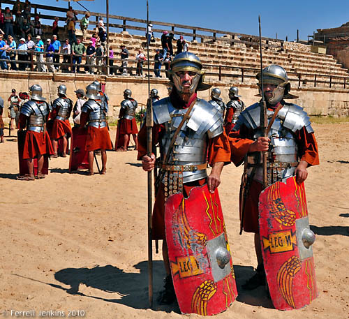
Roman soldiers at Jerash, Jordan. Photo by Ferrell Jenkins.
Repeat from October 8, 2010.
Posted in Archaeology, Bible Lands, Bible Places, Bible Study, Jordan, New Testament, Photography, Travel
Tagged Ministry of Jesus, Roman Empire
Read Part I here.
Churches and religious doctrines were not always what they are today. In fact, in New Testament times (during the first century A.D.) there were no major branches of Christendom, no denominations. There was no church organization larger than a single local church overseen by a plurality of bishops (overseers), elders, or shepherds. These terms were used interchangeably. Today, however, one encounters hundreds of denominational groups, and universal organizations. What has happened since the first century to bring about this change? It did not happen suddenly, but was a gradual process over the centuries.
The Apostles of Christ warned in their sermons and letters of departures or apostasy from apostolic teaching and practice. See Acts 20:29-30, 2 Thessalonians 2:3, and 1 Timothy 4:1 as examples. Notice Paul’s warning to the elders of the church at Ephesus barely a quarter of a century after the establishment of the church in Jerusalem in A.D. 30.
I know that after my departure fierce wolves will come in among you, not sparing the flock; and from among your own selves will arise men speaking twisted things, to draw away the disciples after them. (Acts 20:29-30 ESV)
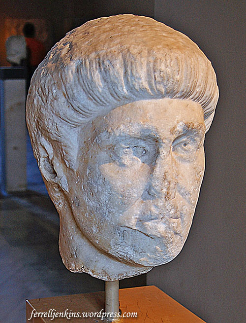
Emperor Constantine the Great (A.D. 307-337). Statue in Istanbul Archaeological Museum. Photo by Ferrell Jenkins.
Historian Philip Schaff wrote about the changes in church government which were evident by the second century:
“We cannot therefore assume any strict uniformity. But the whole church spirit of the age tended towards centralization; it everywhere felt a demand for compact, solid unity; and this inward bent, amidst the surrounding dangers of persecution and heresy, carried the church irresistibly towards the episcopate…. Such a unity was offered in the bishop, who held a monarchical, or more properly a patriarchal relation to the congregation…. And in proportion as every church pressed towards a single centre, this central personage must acquire a peculiar importance and subordinate the other presbyters to itself…” (History of the Christian Church, II:142-143).
“Among the city bishops the metropolitans rose above the rest, that is, the bishops of the capital cities of the provinces” (Schaff, II:153).
Immediately after the discussion of the monarchal episcopate, Schaff discussed “Germs of the Papacy.” In A.D. 588, John the Faster, patriarch of Constantinople [later known as Istanbul], assumed the title of “universal bishop.” The emperor, in A.D. 606, took the title from John and conferred it upon Boniface III, bishop of Rome. This was the first pope, almost 600 years after the establishment of the New Testament church.
F. F. Bruce says,
“There was in apostolic times no distinction between elders (presbyters) and bishops such as we find from the second century onwards: the leaders of the Ephesian church are indiscriminately described as elders, bishops (i.e. superintendents) and shepherds (or pastors)” (Bruce, The Book of Acts, 415).
By the fourth century enough changes had taken place that the Roman emperor Constantine called together the bishops of the churches, mostly from the eastern part of his empire, to discuss various issues that were dividing the churches.

The Arch of Constantine with the Colosseum in the background. Photo by Ferrell Jenkins.
This is where Iznik (ancient Nicaea or Nicea) enters the picture. In A.D. 325 the first of seven Ecumenical councils was held here. After five more councils in Constantinople, Ephesus, and Chalcedon, the seventh of these councils was held again in Nicea.
In the next post we will begin our visit of Nicea.
Posted in Bible Study, Church History, New Testament, Photography, Travel, Turkey
Tagged Roman Empire

You must be logged in to post a comment.