Tag Archives: Palestine

Anathoth – the home of Jeremiah

The prophet Jeremiah was was from the little town of Anathoth northeast of Jerusalem (Jeremiah 1:1). We still lack certainty regarding the specific location of the town, but the name lives on today in the Arab town of Anata.

It is difficult to get a good photo of the hillside town of Anata. I think my photo from several years ago was made from a bus traveling from Jerusalem to Jericho along Highway 1. It was back when some tourist buses still had windows that would let down a few inches at the top. I asked the driver if he could slow down some to give me the opportunity to make a photo.

Jeremiah’s town may be buried somewhere under this village or nearby. The photo is suitable for use in visual presentations.

Anata, an Arab town on the eastern slope of the central mountain range. View to the north. The town of Anata derives it name from the biblical site of Anathoth, the home of the prophet Jeremiah. Photo by Ferrell Jenkins.

Jesus was born in Bethlehem

Now after Jesus was born in Bethlehem of Judea in the days of Herod the king, behold, wise men from the east came to Jerusalem, saying, “Where is he who has been born king of the Jews? For we saw his star when it rose and have come to worship him.” When Herod the king heard this, he was troubled, and all Jerusalem with him; and assembling all the chief priests and scribes of the people, he inquired of them where the Christ was to be born. They told him, “In Bethlehem of Judea, for so it is written by the prophet: (Matthew 2:1-5 ESV)

Last April I visited Bethlehem hoping to see the refurbished Church of the Nativity, but the work was still in progress. However, I did see something new. In the courtyard of St. Catherine’s church, near the statue of Jerome, there was a very nice nativity display that I wish to share with our readers.

Nativity display in the courtyard of St. Catherine's church in Bethlehem. Photo by Ferrell Jenkins.

Nativity display in the courtyard of St. Catherine’s church in Bethlehem. Photo by Ferrell Jenkins.

You may recall that Jerome lived in Bethlehem from about 384 A.D. to 420 A.D. He is best known for translating the ancient Hebrew and Greek manuscripts into what would be called the Latin Vulgate. Our earliest (chronologically) English versions were translated from the Latin rather than from the Greek and Hebrew.

In the past couple of weeks there has been an uptick of interest in previous articles I have written about the birth of Jesus, Bethlehem, and Christmas.

We have compiled an Index of articles dealing with these subject here. Perhaps you will find both the articles and the photographs helpful in your study and teaching.

Barclay’s Gate in the Western Wall

In this post we wish to follow-up on the work of Dr. James Turner Barclay, medical missionary to Jerusalem in 1851-1854 and 1858-1861, which we have written about here (with other links).

Perhaps Turner’s best known discovery was a gate in the Western Wall of the Temple Mount, now known as Barclay’s Gate. Lewis describes briefly the account given by Barclay in The City of the Great King.

While surveying the Haram precinct [which Christians and Jews call the Temple Mount], Barclay noticed a blocked-up entrance, located 82 meters from the area’s southwest corner. The lintel of this gate is below the Maghrabi gate, which tourists use today to enter the Haram from the west. It is above the women’s area of the western wall, just over the stairway that leads into a room on its south side. Only a part of the lintel is still visible. Some time after the gate was filled in, the corridor into which it led was made into a cistern.

Lewis states that Barclay’s discovery was confirmed by Charles W. Wilson, and later by George Adam Smith. He says,

Barclay considered it to have been one of the four gates mentioned by Josephus in his description of the western wall (Jewish Antiquities, book 15, chapter 11, paragraph 5; see Marcus and Wikgren 1963: 199). Benjamin Mazar has identified Barclay’s Gate as the Kiphonos [Coponius] Gate of the Mishnah (Middoth, chapter 1, mishnah 3; see Danby 1933: 590):

Its tremendous single-stone sill, twenty-five feet long and over seven feet high (7.5 x 2.1 meters), rests on the master course of the Western Wall, that is, at the level of the thresholds of several of its gates. The gateway (opening) is 28.7 feet (8.75 meters) high, but the threshold is missing.… Inside the gate, there was once a vestibule which is now blocked by a wall. Behind the wall a passage leads through one or two ancient cisterns with vaulted roofs which are situated under the Haram platform. Before they were converted into reservoirs, they were stone hallways and formed an underground ramp leading in a southerly direction from the Kiphonos Gate to the upper courts of the Temple area (Mazar [The Mountain of the Lord] 1975: 133–34).

I am hopeful that our photographs will make clear the location of Barclay’s Gate for those who wish to get a glimpse of it on their next trip to Jerusalem. The first photo shows the Mughrabi Bridge entrance.

Mughrabi Bridge. Tourists usually enter from Dung Gate and take the bridge up to the only entrance to the platform where the temple once stood allowed for non-Muslims. Photo by Ferrell Jenkins.

Mughrabi Bridge. Tourists usually enter from Dung Gate and take the bridge up to the only entrance to the platform where the temple once stood allowed for non-Muslims. Photo by Ferrell Jenkins.

Notice where it appears that the bridge reaches the Western Wall. In fact, it makes a right turn to the south, and then a left turn to the east where it reaches the gate. That gate is at the level of the platform where the Temple of Solomon, and Herod’s Temple once stood.

This photo shows the structure covering most of the lintel of Barclay's Gate. Photo by Ferrell Jenkins.

This photo shows the bridge and the structure covering most of the lintel of Barclay’s Gate. Photo by Ferrell Jenkins.

This photo was made from the Mughrabi bridge and shows the left side (north end) of the lintel of Barclay’s gate marked in yellow.

Photo made from Mugrabhi gate bridge with the north end of the lintel identified. Photo by Ferrell Jenkins.

Photo made from Mugrabhi gate bridge with the north end of the lintel identified. Photo by Ferrell Jenkins.

The next photo was made from ground level over the dividing screen that separates the women’s section of the prayer wall from that of the men. The visible portion of the lentel looks smaller here than in the previous photo. Two ladies are standing on the steps at the entrance into the small room where more of the lentel can be seen.

Ground level view of the southern end of the lentil showing. Photo by Ferrell Jenkins.

Ground level view with the northern end of the lentel showing. Photo by Ferrell Jenkins.

Leen Ritmeyer has provided numerous drawing of Barclay’s Gate in his books and blog. I recommend that you go there for a better understanding of the gate structure.

  • Ritmeyer Archaeological Design. See the post on “Barclay’s Gate in the Western Wall of the Temple Mount” here. This post includes a photo of the central part of the lintel over Barclay’s Gate.
  • Ritneyer, Leen & Kathleen. Jerusalem: The Temple Mount. See our notice here.
  • Ritmeyer, Leen. The Quest, Revealing the Temple Mount in Jerusalem, pp. 26, 28.
  • Ritmeyer, Leen. Understanding the Holy Temple Jesus Knew, pp. 22-23. The drawings and photos in this book are very nice. See our notice here.

Two books that caught my attention are,

  • Ben-Dov, Meir. In the Shadow of the Temple, pp. 140-143. Ben-Dov includes a full-page drawing of the gate showing the present level, the Omayyad level, and the Second Temple level. He shows eight layers of Herodian stones below the present level. This work incorrectly identifies Barclay as “an American consul in Jerusalem at the end of the nineteenth century and one of the first scholars of Jerusalem.” Barclay was a medical missionary who lived in Jerusalem on two occasions (1851-1854 and 1858-1861).
  • Mazar, Benjamin. The Mountain of the Lord, pp. 133-134. Mazar mistakenly identified Barclay as a “British architect.”

Initially I began with a reference to the following works.

  • Lewis, Jack P. “James Turner Barclay: Explorer of Nineteenth-Century Jerusalem.” Biblical Archaeologist 51 (1988).
  • Lewis, Jack P. Explorers of Bible Lands. Abilene Christian University Press, 2013. This work includes the essay on Barclay and other biographical portraits by Lewis.

Lewis discusses some of the other discoveries made by Turner.

Barclay’s book is not to be forgotten. The City of the Great King; or, Jerusalem As It Was, As It Is, and As It Is To Be is available in Logos format. It seems to be available only in a 10-volume collection of Archaeological and Theological Studies of Jerusalem. It is also available free at Google Books. I note that a cover of the book shows a drawing of the Temple area, including the “Wailing Place” and nearby an “Old Gateway.”

Added Notes – Sept. 29, 2017

The comment below by Outremer [Tom Powers] was held up by WordPress for my approval, and by some appointments I had. When Tom writes I listen. He always adds something of value. I want you to read the comments in full, but I am including the photos here. I knew that one of them was in Ritmeyer’s blog and for that reason did not include it. And I thought of Todd Bolen’s Historic Views of the Holy Land. One of these photos is in the 8-volume set, “The American Colony and Eric Matson Collection.” Details here.

Here is the first photo Tom mentions.

The "al-Buraq" Mosque "built into the vaulted internal gate passage of Barclay's Gate." Eric Matson Photo.

The “al-Buraq” Mosque “built into the vaulted internal gate passage of Barclay’s Gate.” The dark line on the far wall (left of the photo) is “apparently the top of the lintel” (Powers). Eric Matson Photo, 1940s.

The second photo is shown here.

The "al-Buraq" Mosque "named for the winged beast of Moahmmed's legendary Night Journey -- is built into the valulted internal gate passage of Barclay's Gate" (Powers). Photo by Eric Matson.

The “al-Buraq” Mosque, “named for the winged beast of Moahmmed’s legendary Night Journey, is built into the vaulted internal gate passage of Barclay’s Gate” (Powers). Photo by Eric Matson in the 1940s.

Jesus used the camel in His illustrations

Camels are first mentioned in the Bible in the time of Abraham (Genesis 12:16), and they are prominently mentioned in other Old Testament stories such as the account of  Genesis 24. John the Baptist is noted for wearing a garment made of camel’s hair (Matthew 3:4).

A mother camel and her young calf in Palestine (or West Bank). Photo by Ferrell Jenkins.

A mother camel and her young calf in Palestine (or West Bank). Photo by Ferrell Jenkins.

Jesus used the camel to illustrate His teaching. He said,

Again I tell you, it is easier for a camel to go through the eye of a needle than for a rich person to enter the kingdom of God.” (Matthew 19:24 ESV)

and, to the Scribes and Pharisees He said,

You blind guides, straining out a gnat and swallowing a camel! (Matthew 23:24 ESV)

Bal’ama is thought to be Biblical Ibleam

We always wanted to travel through the hill country of Samaria (Manasseh and Ephraim) on our tours, but there were many years that this was not possible due to the political situation. When travel was possible we drove (from the north) through Jenin, the plain of Dothan, Samaria, Shechem (Mounts Ebal and Gerizim, Jacob’s Well), and other sites as time permitted. If we could not travel along the central mountain range we drove through the Jordan Valley.

Sometime when traveling through Jenin, our guide would mention that there is a tel (tell, archaeological mound) on the south side of the city, but we never saw it. Traveling in a bus normally provides a better view because one is sitting higher, but I now understand why we did not see this tel. The excavation report explains that the spring entrance at road level became visible only after the 1996-1997 road work. The road runs through the Wadi Bal’ama.

The site on the south side of Jenin is known as Khirbet Bal’ama, or Khirbet Belameh. Several 19th and 20th century archaeologists identified this site with Biblical Ibleam.

Ibleam was a Canaanite town in the territory given to the Israelite tribe of Manasseh. As the Israelites settled in the land, there were Canaanite cities that they failed to capture. One of them was Ibleam (Joshua 17:11). The Biblical text says,

Manasseh did not drive out the inhabitants of Beth-shean and its villages, or Taanach and its villages, or the inhabitants of Dor and its villages, or the inhabitants of Ibleam and its villages, or the inhabitants of Megiddo and its villages, for the Canaanites persisted in dwelling in that land. (Judges 1:27 ESV)

Thutmose III was the ruler of Egypt (1504-1450 B.C.) during the 18th Dynasty. Some scholars place the beginning of his rule at 1490 and others at 1479.

Thutmose III at the Temple of Amum at Karnak. Photo by Ferrell Jenkins.

Seated statue of Thutmose III at the Karnak Temple. Photo by Ferrell Jenkins.

Thutmose made a military excursion into Canaan and left a record of it on the walls of the Karnak Temple. Our photo shows a few of the bound rulers of various cities. I don’t have a translation of the cartouches and do not know if Bal’ama is shown in this photo, but it is included somewhere on the walls of Karnak.

Part of the city list left by Thutmose III at Karnak Temple. Photo by Ferrell Jenkins.

Part of the city list left by Thutmose III at Karnak Temple. Photo by Ferrell Jenkins.

My interest in Bal’ama was renewed when I read A.D. Riddle’s article in the Bible Places Blog here. Last April, 2016, I had this site in mind when we were able to drive through the West Bank from Galilee to Jerusalem. As we drove south of Jenin I caught a glimpse of the new sign marking the entrance to Bal’ama Tunnel. Note that the sign is in Arabic and English. I may be wrong, but I don’t think this sign was there in 2015 when I drove through Jenin, but I may have been looking to the east of the highway.

Bal'ama is marked as Bal'ama Tunnel on the west side of the road from Jenin to Dothan, Samaria, and Nablus (Shechem). Photo by Ferrell Jenkins.

Bal’ama is marked as Bal’ama Tunnel on the west side of the road from Jenin to Dothan, Samaria, and Nablus (Shechem). Photo by Ferrell Jenkins.

There are two information signs posted at the site of Khirbet Bal’ama. The first reads,

Khirbet Bal’ama is a Canaanite fortified city that occupied a strategic position controlling the historic route of Wadi Bal’ama which connects the Arraba Plain with Marj Ibn Amer (“Jarzeel [Jezreel] Valley”). In the ancient record, the site is identified with the name “Ibleam“, and was mentioned in the Egyptian Royal Archive in the 15th century B.C. With reference to the classical records, Bal’ama was known as “Belemoth”, and was mentioned as a major town during the Bronze Age and beginnings of the Iron Age. It was inhabited during the Persian, Hellenistic, Roman, Byzantine, Early Islamic periods, also during the crusader/Ayyubid, Mamluk and Ottoman periods. Excavations at the site carried out by a Joint Palestinian-Dutch team between 1998 and 2000, revealed the water system and parts of a city walls dating back to the Bronze Age at the western perimeter of the site, ruins for houses dating back to the second Iron Age, a winery from the Roman period and remnants of a tower on top of the hill dating back to the crusader/Ayyubid and Mamluk periods. A cemetery on the southern top of the hill adjacent to Khirbet Bal’ama was discovered as well.

Khirbet Bal’ama is visible to the right of the new building on the slope. There are two entrances to the tunnel; one at street level and another at the level of the platform on the slope.

The site of Khirbet Bal'ama south of Jenin. Photo by Ferrell Jenkins.

The site of Khirbet Bal’ama south of Jenin. Photo by Ferrell Jenkins.

Riddle includes some nice photos of the site, but we can add one with the entrance to the tunnel system open.

Entrance to the tunnel at Khirbet Bal'ama. Photo by Ferrell Jenkins.

Entrance to the tunnel at Khirbet Bal’ama. Photo by Ferrell Jenkins.

Another sign on the entrance plaza describes the water tunnel system.

The water tunnel is located at the eastern foot of Khirbet Bal’ama. It was first described by Victor Guerin in 1874 and then by G. Schumacher [who had earlier excavated at Megiddo] in 1910. The rock-cut tunnel was dug to give access to the water source at the foot of the hill. It was designed primarily to be used in times of war and siege. The Bal’ama water tunnel system is one of the major systems in Palestine, like other systems found in Jerusalem, Tel el-Muteselim (Megiddo), Tel el-Qadah (Hazor) and Tell el-Jazari (Gezer). The tunnel consists of three parts, namely the archway at the lowest entrance, the rock-cut tunnel going upward to the west, and the upper stone-built narrow passage. The discovered tunnel is 115 metres in length; 105 metres of it is rock-cut and includes 57 stairs. Archaeological objects were found, such as pottery vessels, glass objects, coins, and some inscriptions.

And we can add a photo of the actual lower water tunnel. Riddle says,

The tunnel was apparently constructed in the Iron Age, though this is based largely on inference rather than clear, direct evidence

Beginning of the Bal'ama Tunnel on the east side of the city. Photo by Ferrell Jenkins.

Beginning of the Bal’ama Tunnel on the eastern (northeast, Riddle) side of the city. Photo by Ferrell Jenkins.

Due to lunch plans at Samaria and other sites on our schedule for the day we were not able to walk through the tunnel. Always a reason to return.

Riddle cites two excavation reports. He says the first may be difficult to access in the United States, but I am pleased to say that both documents are now available on Academia under the name of Hamdan Taha. This is for those who have a more technical interest in the site.

Taha, Hamdan and Gerrit van der Kooij. The Water Tunnel System at Khirbet Bal’ama. Archaeological Project Report of the 1996–2000 Excavations and Surveys, volume II. Ramallah: Ministry of Tourism and Antiquities, Department of Antiquities and Cultural Heritage. 2007.

Taha, Hamdan. “Excavation of the Water Tunnel at Khirbet Belameh, 1996-1997.” in Proceedings of the First International Congress on the Archaeology of the Ancient Near East, Rome, May 18th-23rd 1998. 2000: 1587-1613.

Dust storms afflict Egypt, Palestine, and Israel

Almost four years ago I wrote a post about the strong East winds of the Middle East, also calling attention to the winds from the south. Several bloggers have called attention to a recent occurrence of the winds affecting Egypt, Palestine, and Israel in particular. I thought it would be appropriate to reprint some of that earlier material here with an update.

— • —

Almost everyone who has visited Israel has learned of the West winds that make their way through the depressions around the Sea of Galilee and create storms on the Sea. Unless you travel in the “transitional season” or in the (dry) summer season you may not have learned about the East wind. This wind is called the sirocco. In Egypt it is known as the khamsin, and in Israel as the sharav.

Denis Baly, The Geography of the Bible (1974 ed., pp. 51-53), explains these winds. He says they occur in the transitional seasons from early April to mid-June, and from mid-September to the end of October. Baly says,

It is this intense dryness and the fine dust in the air which are so exhausting, for other hot days, though troublesome, do not have the same effect. People with a heart condition, nervous complaints, or sinus trouble are particularly affected, but even the mildest-tempered person is apt to become irritable and to snap at other people for no apparent reason. Tourists find the sirocco especially frustrating, for not only does travel become fatiguing, but the fine yellowish dust which fills the air drains it of all color, blots out all but the immediate vicinity, and makes photography a mockery.

Here is how Larry Haverstock described his day walking the Jesus Trail in an Email to me.

No blog last night because of the storm. I woke to high winds from the east which dusted up the air so badly that photos were mostly useless. Worst part was that it was directly against me and really HOT. Pushing against 20+ mph winds really took the steam out of me. By the end of the day I was utterly exhausted.  Drank my full 3 litres and had good dinners and breakfasts, but energy levels are still very low.

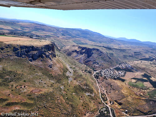
The photo below is one of the aerial shots Larry and I made a week earlier. It was made while flying over the west shore of the Sea of Galilee, with the view to the west. You can see Mount Arbel and the Wadi Hamam below. The Via Maris runs in this valley which is also called the Valley of the Doves. You will notice two lines of mountains further west.

I am rather sure that this is the route Larry was walking. Larry lived in Washington state for many years. I think he is not bothered by the sudden rains, but the intense heat and strong wind from the east may be another matter. I want you to think about the fact that all of the biblical characters from the Patriarchs to Jesus and His disciples encountered conditions similar to these (and worse).

Aerial view of Arbel, Wadi Hamam, and the Via Maris. Photo by Ferrell Jenkins.

Aerial view of Arbel, Wadi Hamam, and the Via Maris. Photo by Ferrell Jenkins.

Baly cites several biblical references to the east and south winds that bring in the hot air and the dust storms. He says, “Where the mountains come close to the sea a strong sirocco pours down the slopes like a flood, at 60 miles an hour or more, stirring the sea into a fury.”

By the east wind you shattered the ships of Tarshish. (Psalm 48:7 ESV)

In the prophecy against Tyre, Ezekiel says,

“Your rowers have brought you out into the high seas. The east wind has wrecked you in the heart of the seas. (Ezekiel 27:26 ESV)

Notice Elihu’s comments to Job about the south wind.

Do you know the balancings of the clouds, the wondrous works of him who is perfect in knowledge,  you whose garments are hot when the earth is still because of the south wind?  (Job 37:16-17 ESV)

Jesus also observed the effect of the south wind:

And when you see the south wind blowing, you say, ‘There will be scorching heat,’ and it happens. (Luke 12:55 ESV)

Do you remember Jonah’s problems after enjoying the shade of his plant?

When the sun rose, God appointed a scorching east wind, and the sun beat down on the head of Jonah so that he was faint. And he asked that he might die and said, “It is better for me to die than to live.” (Jonah 4:8 ESV)

Baly calls attention to the effect of the spring siroccos on the crops.

The spring siroccos destroy the winter grass and may damage the crops if they come too soon, and hence they appear constantly in the Bible as a symbol of the impermanence of riches or of human life.

Note these additional references in your own study: Psalm 103:16; Isaiah 40:6-8; Hosea 13:15; Ezekiel 17:10; James 1:11. In a recent post Barry Britnell (Exploring Bible Lands) add Deuteronomy 28:15-24 here.

Larry Haverstock’s own description which he later wrote here in his blog is included here. (There are some great pictures of his descent from Mount Arbel.)

It was while making this first effort of the morning that I encountered my nemesis for the rest of the day.  It was only 10 o’clock but already a hot wind was blowing in my face.  What I couldn’t know at that moment was that as I climbed the western slope the mountain was acting as a shield so that I wouldn’t feel the brunt of this wind until I summited.  As soon as I stepped out upon the actual heights of Arbel I knew I was in for an unusual day.

The view was phenomenal and despite the dust in the air I got the following shot of the Plain of Gennesaret.  This is the Northwest corner of the Sea.  Just out of sight on the waterfront to the right are the ruins of ancient Magdala from whence one very famous Mary came.  All the rest of the shoreline is the area in which Jesus spent a tremendous amount of time, preached some of His very most famous sermons, worked many miracles, and made His home in Capernaum which is along the shore as it turns the corner and heads off to the right in the distance.  Much food for thought when you stand in this place.

Unfortunately, the wind was howling and dangerous here.  I don’t have a weather report, but guess it was in the vicinity of 40 miles an hour since I was actually being pushed off balance and forced to take a step now and then to keep from falling over.  It did give me pause, but I was determined to take the shorter, harder, steeper trail down, so I spent about 20 minutes re-rigging my equipment.  Fearing the monopod “sword” might jam itself on the rocks somehow I removed it from the under arm position and strapped it vertically to the back of the pack.  Then, using the extra leather chin strap rope I’d brought along for emergency, I took off my hat and lashed it on the back of the pack too.  This hat had a very wide and stiff brim which had helped shield my face from the gale on the way up, but was now a liability, capable of catching the wind and pulling me off balance, so I stowed it.  Then I took the pack’s belly straps and lengthened them so that rather than directly clutching my stomach, they came out and over the front pack so that I could tightly restrain it from swinging.  Having thus reduced my exposure to the wind I started down.

It was now man against mountain, rather than nonchalant tourist with a camera time.…

Shortly afterwards I called attention to the comparative photos that Dr. Carl G. Rasmussen has included in his Zondervan Atlas of the Bible, and on his Holy Land Photos website here. These photos provide a vivid contrast that the dust storms make.

In today’s Weekend Roundup at Bible Places Blog, Todd Bolen calls attention to the current article in The Jerusalem Post here, and the 25 or so outstanding large photos from Egypt, Palestine, and Israel in London’s Daily Mail here. Be sure to look at these photos.

I have experienced a delayed flight in Egypt due to the sand storms, and the scorching hot wind with dust in Israel, but nothing like these photos reveal.

Florida College Annual Lectureship 2015

Many of our readers attend the annual Florida College Lectureship. The theme for the February 2-5, 2015 lectureship is “Light Shall Shine Out of Darkness.

I am scheduled to present an illustrated lecture on “The Roman Imperial Cult in Palestine” Tuesday morning at 10 a.m. in Puckett Auditorium. It would be my pleasure to see some of our readers in the audience.

The complete lectureship program is available here.

Florida College Press has recently published two of my out-of-print books. Revised editions of Biblical Authority and The Finger of God are back on the shelf.

Two revised books by Ferrell Jenkins now available.

Two revised books by Ferrell Jenkins now available.

The bookstore manager asked me to do a book signing Thursday between 12:30 and 1:30 p.m. Love to see you there.

Other books in print include:

  • Studies in the Book of Revelation
  • The Early Church
  • The Theme of the Bible
  • God’s Eternal Purpose (Ephesians)
  • Better Things (Hebrews)

Several books that I have edited or have a chapter are listed if you search with my name at the Florida College Bookstore site here.


Temple Mount, Pools, Jericho, Jordan River

Today was a great day for travel in and around Jerusalem. We started the day by visiting the Temple Mount. This is a place filled with Bible history relating to Abraham, David, Solomon, Jesus, and Peter (as well as all of the apostle). It is a place destroyed by the Babylonians (586 B.C.) and the Romans (A.D. 70).

The site has been under Islamic control since the 7th century.

We visited the Pools of Bethesda (John 5) and the Pool of Siloam (John 9).

Yesterday, by the time we visited Masada, Qumran, and Jericho, it was too late to visit the baptismal site on the Jordan River, a site known as Qasr el-Yahud. This site on the Israel side is across from the Jordanian site identified as Bethany beyond the Jordan (John 1:28).

We stopped in Jericho for lunch at the Temptations Restaurant. The restaurant is located on the south end of Tell es-Sultan, identified with Biblical Jericho (Joshua 3-6).

The restaurant has lots of parking space for tour buses and good food. That’s a good combination in the tourist industry. As I was leaving I noticed a sign with the wording “View of Jericho”, and thought I should check it out. It took a climb of 11 flights of stairs to reach the roof. It was worth it for the view which was exceptionally good in all directions.

The view to the north is of Tel es-Sultan. See below. You may notice some wires (cables) across the photo. These are for the cable car that goes up to the traditional Mount of Temptation (Matthew 4).

Jericho (Tell es-Sultan) from the south. Photo by Ferrell Jenkins.

Jericho (Tell es-Sultan) from the south. Photo by Ferrell Jenkins.

Afterwards we visited the Jordan River. On the way back to Jerusalem we stopped by the St. George Monastery in the wilderness of Judea. The monastery building appear to hang on the side of a cliff overlooking the Wadi Qilt. Quite a sight.

We stopped at the Inn of the Good Samaritan (Luke 10:25-37) which now houses many mosaic floors from Jewish synagogues, Samaritan Synagogues, and Byzantine Churches, as well as a few other interesting artifacts.

It was a great day.

A pleasant stop in Samaria

It was still raining quite a bit in the north of the country yesterday, but we enjoyed some good visits. The morning was clear for the visit to Beth Shean (Beth-shan). We approached the overlook of the Jezreel Valley from Jezreel in a light drizzle.

From that spot one gets a view of Jezreel Valley, Mount Gilboa, the Hill of Moreh, and the spring below Jezreel. We discussed Gideon and the Midianites, the Ahab and Jezebel and their deaths, Naboth’s Vineyard, Elijah and the prophets of Baal, the coming of Jehu. What a great visual backdrop this provided!

We were able to travel along the central mountain range through Samaria. This is not always possible when traveling in the country. The road up to the Hill of Samaria is in bad repair (what a shame), but our driver was able to negotiate the ruts and get us to the top.

I have eaten several times before at the Samaria Restaurant in Sebastia. It is located across from the Roman agora of ancient Samaria. The owner, Mahmud Ghazal is a pleasant person. He studied at the University of Alabama, with a degree from UAB. If you are able to go to Samaria I suggest you try this restaurant, and then visit his shop.

There is a nice wall exhibit in the restaurant showing some of the antiques from the area – from the not too distant past. Take a look.

Antiques at the Samaria Restaurant, Sebastia, Palestine. Photo by Ferrell Jenkins.

Antiques at the Samaria Restaurant, Sebastia, Palestine. Most of these have to do with agricultural practices. Photo by Ferrell Jenkins.

Most of these antiques have to do with agricultural practices that were common in Bible times. On the right you have a wooden plow with a metal plow point. On the left is a threshing sledge. On the right you see two winnowing forks and a sickle. I don’t have the time to list biblical references for all of these items. Many of them we have discussed before on this blog.

The rain let up long enough for us to have a good visit of the archaeological ruins of ancient Samaria.

We also stopped at Jacob’s Well, drove up on Mount Gerizim for a view of the area below. Then we continued to our hotel in Jerusalem.

Rain was forecast for Jerusalem today, so we went through the Wilderness of Judea and drove along the Dead Sea to Masada. There were large crowds at Masada. Some of them probably had the same idea we did and changed their plan to be in a dry place for the day.

Hopefully the skies will be clear tomorrow. We are having a great learning experience, and a great time, anyway.

Leeches in Sea of Galilee; Palestinian Village; Jericho

Sea of Galilee invaded by leeches. For the second time in 7 years the lake has an explosion of leeches. The article in Haaretz says,

Standing in the water for as little as two minutes will cause your legs to be covered in hundreds of leeches. These particular types are not blood-suckers, making them relatively easy to remove once one is out of the water

Causes for the large number of leeches include “human activity, including pollution, poisoning and overpumping.”

Read the full article here.

The Sea of Galilee was central to much of the ministry of Jesus.

While walking by the Sea of Galilee, he saw two brothers, Simon (who is called Peter) and Andrew his brother, casting a net into the sea, for they were fishermen. (Matthew 4:18 ESV)

Palestinian Village uses Roman irrigation system to continue terraced farming near Bethlehem. Read the story, with beautiful photo, in The New York Times here.

Tell es-Sultan/Jericho. Sepienza University in Rome, in cooperation with the Palestinian General Directorate of Antiquities, has published a Palestine Archaeological Databank and Information System. Check here for maps and other information. Our readers will likely be interested in the excavation reports on Tell es-Sultan/Jericho here. Click on the Results 2012 photo for the most recent work by the Italian-Palestinian Expedition at Jericho. Every visitor to the site will welcome is the new paths, identifying signs, and general clean-up of the site.

I was especially pleased to see the Digital Visit plan of the site. Click on it was a colorful, readable plan of the site like the central portion of the one shown below. Prof. Lorenzo Nigro is the director of the excavation.

Tourist Path and Main Monuments at Tell es-Sultan/Jericho. Photo by Ferrell Jenkins.

Tourist Path and Main Monuments at Tell es-Sultan/Jericho. Photo by Ferrell Jenkins.

Jericho is important in Old Testament history (Joshua 6).

HT: Bible Places Blog; Jack Sasson; Barry Britnell; “La Sapienza” Expedition to Palestine.