Category Archives: New Testament

Traveling in Europe

For the past week my wife and I have been traveling in Europe, revisiting some of the places we have enjoyed with groups over the years. Berlin is one of those places. We did some of the typical sightseeing, but the main visit was the museums with Ancient Near Eastern collections.

My first visit to the Pergamum Museum was about 1978. I returned several times when the Museum was behind the Berlin Wall, and have been there several times since the fall of the wall.

The Egyptian collection formerly was in the west, but now is housed in the Neues Museum in the building on the left of the photo below. Considerable construction is underway in the area. The former entry to the Pergamum Museum is closed. The red sign in the distance points to the temporary entry. Crowds are so large that people wait in line for four hours or more to buy at ticket and gain admission to the Museum. The only way to avoid this is to purchase a ticket online with a 30 minute time span for admission. I purchased a two day Museum pass after I arrived in Berlin and then made an appointment online for two different days. A single entry costs about 13 Euro (a little under $20 per entry).

berlin_pergamum-crowd-01fj_1

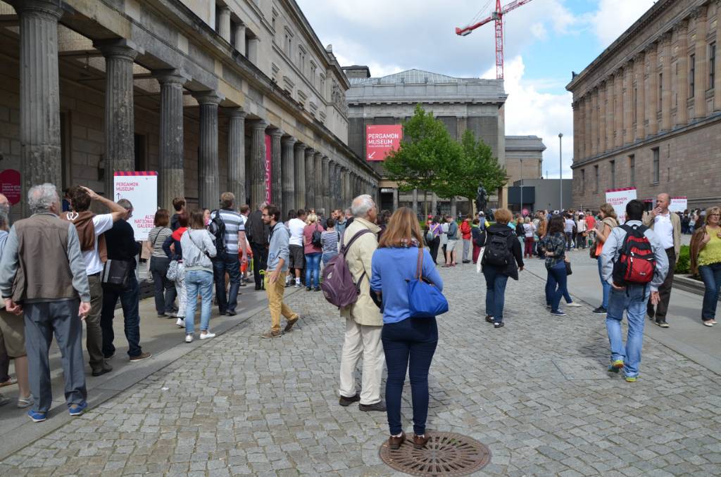
Crowds waiting in line to enter the Pergamum Museum. Photo by Ferrell Jenkins.

The Pergamum Altar already has some scaffolding in place. At the end of September the exhibition will close for __________ years (you know about government projects).

The visit was somewhat disappointing because of the appointment requirement, but mostly because portions of the Museum are closed. Whole galleries pertaining to the the Greco-Roman world are not open. The great Ishtar Gate from Babylon is open, and the Miletus Marketgate, which was covered with netting the last time I was in Berlin, is now one of the nicest exhibits. The halls dealing with Babylon, Assyria, and the Hittites were open.

Later I hope to share some representative photos with you, but I confess that I am traveling with a Samsung Tab 4 and have had difficulty getting the single photo above loaded into the blog. I refused to pay the $20+ a day to be online at the hotel. I only ate at one place that offered time online, and they could not locate the card with the passport. 😦

We are in Paris now and I have Wi-Fi at the hotel. The Louvre is closed on Tuesdays, so I went to the Tourism office and purchased tickets to the museum in order to avoid the long lines the next two days. The tickets here are under $20 per entry.

If any reader has experience in loading photos from an Android tablet into WordPress I would be glad to hear about it. Who knows, maybe I will be able to load a second photo.


Boxing in the Greek world

My friends David and Sharon Runner recently traveled with us in Turkey, but made additional excursions into Greece and Italy. David agreed to share this photo of “The Boxer” from the National Roman Museum in Rome.

"The Boxer" in the National Roman Museum. Photo by David Runner.

“The Boxer” in the National Roman Museum. Photo by David Runner.

David describes the statue: “This famous Greek statue called “The Boxer” dates from around 330 B.C. and depicts an ancient fighter, apparently after a match, still wearing his caestus, a leather wrap used as boxing gloves. The small white objects at the bottom of the statue are motion sensors that chime if you get too close. (I found out a couple of times as I moved in a little too much for some close-up pictures.)”

Below is a closeup of the boxers gloves, showing his “brass knuckles.”

Closeup of the hands of "the Boxer". Photo by David Runner.

Closeup of the hands of “the Boxer”. Photo by David Runner.

Paul used a boxing illustration to describe his own disciplined work in preaching.

So I do not run aimlessly; I do not box as one beating the air. But I discipline my body and keep it under control, lest after preaching to others I myself should be disqualified. (1 Corinthians 9:26-27 ESV)

Rare hoard of coins from pre-AD 70 discovered near Jerusalem-Tel Aviv highway

The Israel Antiquities Authority announces today the discovery of a box containing 114 bronze coins dating to Year Four of the Great Revolt (Jewish Revolt against the Romans). The discovery was made several months ago during work on the new Highway 1 project (between Jerusalem and Tel Aviv).

Coin hoard as it was found in the excavation. Photo Vladimir Nuhin, IAA.

Coin hoard as it was found in the excavation. Photo Vladimir Nühin, IAA.

According to Pablo Betzer and Eyal Marco, excavation directors on behalf of the Israel Antiquities Authority, “The hoard, which appears to have been buried several months prior to the fall of Jerusalem, provides us with a glimpse into the lives of Jews living on the outskirts of Jerusalem at the end of the rebellion. Evidently someone here feared the end was approaching and hid his property, perhaps in the hope of collecting it later when calm was restored to the region”. All of the coins are stamped on one side with a chalice and the Hebrew inscription “To the Redemption of Zion” and on the other side with a motif that includes a bundle of lulav between two etrogs. Around this is the Hebrew inscription “Year Four”, that is, the fourth year of the Great Revolt of the Jews against the Romans (69/70 CE).

The hoard was concealed in the corner of a room, perhaps inside a wall niche or buried in the floor. Two other rooms and a courtyard belonging to the same building were exposed during the course of the archaeological excavation. The structure was built in the first century BCE and was destroyed in 69 or 70 CE when the Romans were suppressing the Great Revolt.  Early in the second century CE part of the building was reinhabited for a brief period, which culminated in the destruction of the Jewish settlement in Judea as a result of the Bar Kokhba rebellion. This is attested to by three complete jars that were discovered embedded in the courtyard floor.

It seems that the residents of this village, like most of the Jewish villages in Judea, were active participants in both of the major uprisings against the Romans – the Great Revolt and the Bar Kokhba Revolt. As a result of their involvement the place was destroyed twice, and was not resettled.

The Israel Antiquities Authority and Netivei Israel Company are examining the possibility of preserving the village remains within the framework of the landscape development alongside the highway.

Pablo Betzer, IAA District Archaeologist for Judah, with a coin from Year Four of the Great Revolt. Photo Vladimir Nühin, IAA.

Pablo Betzer, IAA District Archaeologist for Judah, with a coin from Year Four of the Great Revolt. Photo Vladimir Nühin, IAA.

This discovery might remind Bible readers of the illustration used by Jesus.

The kingdom of heaven is like treasure hidden in a field, which a man found and covered up. Then in his joy he goes and sells all that he has and buys that field. (Matthew 13:44 ESV)

HT: Joseph Lauer

More artifacts of the Tenth Roman Legion

We had a good response to our recent posts, here and here, about the Roman Tenth Legion in Jerusalem.  I will post a few photos of other artifacts that are readily available for those who visit Israel.

The first is an inscription of the eighth cohort of the Tenth Legion. According to the accompanying sign in the Israel Museum this limestone inscription comes from Jerusalem or Samaria and belongs to the first or second century A.D. The inscription reads “LEG X FRE COH IIX” and is decorated with dolphins and a wild boar, symbols of the legion.

Inscription of the Eighth cohort of the Tenth Legion. Israel Museum.

Inscription of the eighth cohort of the Tenth Legion. Photo by Ferrell Jenkins.

About halfway between Jerusalem and Bethlehem is the site of Ramat Rachel. It was first occupied in the 7th century B.C. Stratum III revealed evidence of a Roman villa dating to the 3rd and 4th centuries A.D. Some of the clay tiles from the villa are displayed in the hotel at the site.

Information about Ramat Rachel is available on the Archaeological Project website here.

Tile of the Tenth Legion from Ramat Rachel. Photo by Ferrell Jenkins.

Tile of the Tenth Legion from Ramat Rachel. Photo by Ferrell Jenkins.

Finally, here is a tile fragment with a stamp of the Tenth Legion. The inscription reads “LG X F.” A wild boar and a battleship are the symbols on this one. The Israel Museum says this tile dates to the 1st-2nd century A.D.

Tenth Legion tile in the Israel Museum. Photo by Ferrell Jenkins.

Tenth Legion tile in the Israel Museum. Photo by Ferrell Jenkins.

The Roman period in the Holy Land is usually dated from about 63 B.C. to A.D. 323. This includes the entire period of Jesus, the early church, and the New Testament, but it also includes the time of the destruction of Jerusalem and the period when Jerusalem was rebuilt by the Emperor Hadrian and named Aelia Capitolina.

Added Note: See the helpful comments by Tom Powers below. Tom is licensed as a guide in Israel, but is no longer living there. Here is the photo he mentions in the comment about the reused stone in the wall of the Old City near Jaffa Gate.

Partial stone bearing inscription of the Tenth Legion reused in the wall of the Old City near Jaffa Gate. Photo by Tom Powers.

Partial stone bearing inscription of the Tenth Legion reused in the wall of the Old City near Jaffa Gate. Photo by Tom Powers.

The Tenth Roman Legion in Jerusalem

Students of the Bible are aware that the city of Jerusalem, including the Herodian temple, was destroyed by the Romans in A.D. 70. Vespasian commanded the Romans in the north of the country. When he learned of the death of Nero he began his return to Rome and left his son Titus in command of the military forces.

When Titus began to position his forces around the city of Jerusalem, he called the tenth legion from Jericho to come up to the Mount of Olives and take their position there.

and as these were now beginning to build, the tenth legion, who came through Jericho, was already come to the place, where a certain party of armed men had formerly lain, to guard that pass into the city, and had been taken before by Vespasian. These legions had orders to encamp at the distance of three quarters of a mile from Jerusalem, at the mount called the Mount of Olives, {c} which lies opposite the city on the east side, and is parted from it by a deep valley, interposed between them, which is named Kidron. (Josephus, Jewish Wars 5:69-70)

Jesus had prophesied about forty years earlier that the Holy City would be surrounded by armies.

But when you see Jerusalem surrounded by armies, then know that its desolation has come near. (Luke 21:20 ESV)

The word used for armies (stratopedon) is used in literature of the time to specify a legion or a camp (see BDAG and MM).

Archaeological discoveries have supplemented the writings of Josephus to provide evidence of the presence of the tenth legion in Jerusalem. In addition to the column near Jaffa Gate that we mentioned in the previous post, we here call attention to some other evidence that is readily available for anyone who wishes to see it. Here, I call attention to a Roman milestone.

Roman milestone found near the Temple Mount in Jerusalem mentions Vespasian, Titus, and the Tenth Legion. Displayed in Israel Museum. Photo by Ferrell Jenkins.

Roman milestone found near the Temple Mount in Jerusalem mentions Vespasian, Titus, and the Tenth Legion. Displayed in Israel Museum. Photo by Ferrell Jenkins.

The Israel Museum sign associated with the milestone reads,

Near the Temple Mount in Jerusalem, a milestone bearing a Latin inscription was discovered. The inscription mentions both the Roman emperor Vespasian and his son Titus, commander of the Roman army at the time of the suppression of the Great Revolt and had been deliberately effaced, seems to have mentioned the name of Flavius Silva, procurator of Judea and commander of the Tenth Legion, responsible for both the destruction of Jerusalem and the conquest of Masada. The inscription was carved by soldiers of the Tenth Legion.

I have a few more photos of artifacts mentioning the tenth legion that I hope to post soon.

Roman Roads and Milestones

A new website devoted to Roman Roads and Milestones in Judaea/Palaestina has recently come to our attention. This site is co-sponsored by the Kinneret College on the Sea of Galilee Department of Holy Land Studies and Tel Aviv University IMC-Israeli Milestone Committee. Most readers will know that Kinneret is the Hebrew name for the Sea of Galilee. The website includes articles by the late Israel Roll and others, as well as maps showing the location of the roads. Many of the articles are in Hebrew or another language other than English. The maps, however, should be useful to those who do not read Hebrew.

The English website is available here. (If it links to the Hebrew page look in the upper left hand corner and click on EN.)

Good Bible atlases include a map of the known roadways. See, for example, the following:

  • Rasmussen, Zondervan Atlas of the Bible. Rasmussen includes a map showing the Natural Routes/Roads, and a discussion of International Routes.
  • Beitzel, The New Moody Atlas of the Bible. Beitzel includes a map showing The Roads of Palestine and a discussion of the principles back of making decisions about the roads.
  • Schlegel, Satellite Bible Atlas. The second map in this atlas shows the Regions and Routes of the Land of Israel.

Our photo below shows remains of the Roman road that Jesus might have taken from near Nazareth to the Sea of Galilee. These roads are often in danger of destruction by careless builders and farmers.

The Roman Road near Golani Junction in Galilee. This road collected Diocaesarea (Zephoris) and Tiberias. Photo by Ferrell Jenkins.

The Roman Road near Golani Junction in Galilee. This road connected Diocaesarea (Zephoris) and Tiberias. Photo by Ferrell Jenkins.

Jesus taught His disciples about the attitude they should have toward the Roman authorities.

And if anyone forces you to go one mile, go with him two miles.(Matthew 5:41 ESV)

New Testament writers gave distances in their descriptions of travel from one city to another. Luke says that Emmaus was about seven miles from Jerusalem (Luke 24:13). John says that Bethany was about two miles from Jerusalem (John 11:18).

Milestones were common in Roman times and numerous ones have been found throughout the land of Israel. I understand that the milestone below is from the Jezreel Valley. It is one of many displayed on the grounds of the Beit-Sturman Museum near En Harod.

Roman Milestone from the Jezreel Valley. Photo by Ferrell Jenkins.

Roman Milestone from the Jezreel Valley. Photo by Ferrell Jenkins.

HT: Jack Sasson

Gaza is in the news again

After my first tour to the Bible Lands, including Rome, Greece (Athens and Corinth), Egypt, Lebanon, Syria (Damascus), Jordan, and Israel, in April/May, 1967, I decided to make a second tour the following year. For many years, I always added some new places on each tour. In 1968 I added Beersheba and Gaza. The Gaza Strip (named such because of the long, narrow size of the small entity) had been under Egyptian control for several decades until June, 1967
There was not much to see at Gaza. By the time we visited in 1968, Gaza was under Israeli control. We drove to the coast where there were only a few houses and some small fishing boats. This is one of the few slides that I have to illustrate the visit to Gaza.

Gaza on the Mediterranean Sea in May, 1968. Photo by Ferrell Jenkins.

Gaza on the Mediterranean Sea in May, 1968. Photo by Ferrell Jenkins.

Gaza is mentioned several times in the Old Testament. Here is a summary of these references.

  • Gaza was the southwestern boundary of the Canaanites in the table of Nations (Genesis 10:19).
  • The original inhabitants of Gaza were replaced by the Caphtorim, likely the ancestors of the Philistines (Deuteronomy 2:23).
  • Joshua defeated Canaanites “even as far as Gaza” (Joshua 10:41).
  • Joshua eliminated the Anakites except in Gaza, Gath, and Ashdod (Joshua 11:21-22). We recognized these cities as later belonging to the Philistines.
  • Gaza is listed as belonging to the tribe of Judah (Joshua 15:47; Judges 1:18).
  • The Midianites oppressed Israel, “as far as Gaza”, for seven years (Judges 6:4).
  • Samson had contact with the inhabitants of Gaza (Judges 16).
  • Gaza is listed as one of the five Philistine cities in the time of the Israelite Judges (1 Samuel 6:17).
  • Solomon controlled territory as far southwest as Gaza (1 Kings 4:24).
  • Hezekiah defeated the Philistines as far as Gaza and its territory (2 Kings 18:8).
  • Jeremiah makes reference to Gaza being conquered by Pharaoh (Jeremiah 47:1).
  • The prophets of Judah pronounced judgments upon Gaza (Amos 1:6-7; Zephaniah 2:4; Zechariah 9:5).

The only New Testament reference to Gaza is in Acts 8:26. Philip the evangelist was instructed to go south on the road that descends from Jerusalem to Gaza. English translators struggle with the issue of whether the city was desert, or the road leading to the city ran through a desert area. (I will leave that for some other time.)

The first display one sees as he enters the archaeology wing of the Israel Museum is that of the anthropoid coffins from Deir el-Balah, a site south of Gaza city. The coffins, excavated by Trude Dothan in 1972, bear evidence of Egyptian influence. They date to the 13th century B.C.
Anthropoid Coffins from Deir el-Balah in the Israel Museum. Photo by Ferrell Jenkins.

Anthropoid Coffins from Deir el-Balah in the Israel Museum. Photo by Ferrell Jenkins.

Reprint from January 7, 2012.

John was “on the island called Patmos”

John, the writer of the book of Revelation, was “on the island called Patmos, because of the word of God and the testimony of Jesus” (Rev 1:9). I am convinced that this was the apostle John. He was there because of (Greek dia, on account of) the word of God. Filson says this could mean either banishment, or banishment to hard labor. He points out that the word of God and witness or testimony are used in Revelation 6:9 and 20:4 “in reference to a persecution situation” (Interpreter’s Dictionary Bible III:677).

The Romans used the island as a penal settlement to which they sent political agitators and others who threatened the peace of the empire (Tacitus Annals 3.68; 4.30; 15.71). According to Eusebius, John was banished to Patmos by the Emperor Domitian, A. D. 95, and released 18 months later under Nerva (HE III.18.1; 20.8-9).

View of the port of Skala from Chora. Photo by Ferrell Jenkins.

View of the port of Skala from the monastery at Chora. Photo by Ferrell Jenkins.

Patmos is a rocky island off the west coast of Asia Minor in the Aegean Sea, about 37 miles southwest of Miletus. The island is one of the Dodecanese (twelve) or of the Southern Sporades. It is about 10 miles long (N–S) and 6 miles wide at the north end, and consists of about 22 square miles of land area. The island is mountainous and of irregular outline. Some visitors to the island have suggested that the natural scenery “determined some features of the imagery of the Apocalypse” (HDB III:693-94).

Patmos has been a part of Greece since 1947, and may be reached by boat from Piraeus, Samos, Kos, or Rhodes. The ferry from Samos takes about 2 1/2 hours, arriving at the port of Skala. Some cruise ships sail from Kusadasi, Turkey, to Patmos.

On the way from Skala to Chora, the only other town on the island, one passes the Monastery and Cave of the Apocalypse. This site is marked as the traditional place where John received the Revelation.

At Chora, the monastery of St. John the Theologian dominates the island. It was built by a monk called Christodulos (slave of Christ) in A. D. 1088. The monastery library is noted for its manuscripts, but especially for its collection of more than 200 icons. The oldest book in the library is part of a 6th century codex of Mark (Codex Purpureus). The second oldest manuscript is an 8th century A. D. copy of Job.

Bell tower on the Monastery of St. John the Theologian at Chora. Photo by Ferrell Jenkins.

Bell tower on Monastery of St. John the Theologian at Chora. Photo by Ferrell Jenkins.

The Bosphorus − “a liquid line”

For years I have received Saudi Aramco World (Saudi was added to the name a few years ago). From time to time there are articles pertaining to some portion of the Bible World. The March/April 2014 issue has an article by Louis Werner entitled “Bosporus: Strait Between Two Worlds.” The leading paragraph sets the tone for the article.

Look at an atlas of the oceans, and one place always seems to catch the eye. The Bosporus, that narrow waterway connecting the Black Sea to the Sea of Marmara, which cuts the city of Istanbul into two halves, stands out alone among the world’s other major straits and canals. Along with the wider twin, the Dardanelles, the Bosporus famously divided east and west, while the rest − the Suez and Panama Canals, the Malacca and Magellan Straits, to name but a few − link different regions.

Its function as a barrier between continents, a liquid line strung between Europe and Asia, has given the Bosporus such prominence in both history and legend: The ancient Greeks sailed up the strait to their Black Sea colonies, the Persian King Darius built a floating bridge across it in the fifth century BCE; in 1451 CE, Mehmet the Conqueror built a fort on its European bank to strangle Constantinople; during the Cold War, Joseph Stalin said that Turkish control over the Bosporus held the USSR “by the throat”; today it is an essential part of global shipping trade in petroleum.

The Bosphorus (more common spelling) has fascinated me since I first saw it in 1968. I have enjoyed looking at the great vessels traveling one way or the other through the waterway. Tour groups enjoy a boat ride on the Bosporus. The photo below shows one of the more narrow areas. Cargo ships can be seen awaiting their turn to go through the strait.

Cargo and tourists making their way through the Bosporus. Photo by Ferrell Jenkins.

Cargo and tourists making their way through the Bosporus. Photo by Ferrell Jenkins.

In the past we have written about the delivery of Peter’s epistles with the suggestion that the messenger came through the Bosphorus into the Black Sea and along the coast of Bithynia and Pontus. If this is correct, and I think it is, the Bosphorus was an important waterway to those Christians addressed by Peter. See “The Delivery of Peter’s Epistles” here.

Changes at the Bema in Corinth

Luke records, in the book of Acts, an important historical event involving Paul during the 18 months he worked at Corinth (Acts 18:12-17).

The photo below, made in May 2012, shows the actual platform or bema mentioned in Acts 18. Popular English versions use the terms tribunal, judgment seat, place of judgment, or judge’s bench.

The Bema at Corinth where Paul stood before Gallio. Photo by Ferrell Jenkins.

The Bema at Corinth where Paul stood before Gallio. Photo by Ferrell Jenkins.

The bema dates to A.D. 44, but could be as early as the time of Augustus (Murphy-O’Connor, St. Paul’s Corinth, 28).

You see that some sort of work was going on around the bema. Notice the rope, the pile of sand, and the bags on the top. I remarked to some of our tour members that we formerly were able to stand on the bema. I feared this might be an end to that practice.

Yesterday I was catching up on some blogs that I enjoy reading. One of those is Gordon Franz’ Life and Land. Gordon was writing about a tour he led earlier this year. One line caught my attention. In telling about the visit to Corinth, Gordon says,

Recently the Bema was repaired and reopened so tourists can walk up and stand where Gallio passed judgment on the Apostle Paul (Acts 18:12-17).

Anyone have a nice photo to share of the bema since the restoration?