Category Archives: Bible Study

Dead Sea: Fact and Fun

We set the clock to get up in time to see the sunrise across the Dead Sea. I was pleased with the result as the sun rose in the vicinity of Biblical Edom sending a ray across the Dead Sea. The smaller light to the left of center is a reflection from the camera lens.

Now Lot went up out of Zoar and lived in the hills with his two daughters, for he was afraid to live in Zoar. So he lived in a cave with his two daughters. (Gen. 19:30 ESV)

While we were at the southern end of the Dead Sea we drove a little further south to see the formation nicknamed “Lot’s Wife.” This is based on the Biblical story of the destruction of Sodom and Gomorrah (Genesis 19. See especially Genesis 19:26, and the reference by Jesus in Luke 17:32).

As usual, these photos are available for download for use in teaching as long as credit is given to this source. For commercial use see our Photo Permission page.

Recent travel in Israel

Paulette and I enjoyed two weeks of travel in Israel the first part of May. It was her first opportunity to see and learn the land. I led tours to the Bible world almost annually from 1967 to 2016 and have made personal study trips to Israel or some other part of the Bible world with a friend every year except the first year of the recent pandemic. I wanted to show Paulette places that she had read about many times in her Bible study. Though she believes the Biblical accounts about the activities of Jesus and his disciples, as well as the judges, prophets and other writers of the Bible, I watched as the Biblical text came alive to her in a new way. We did not see as much as I had hoped but we were able to work out from Jerusalem and Tiberias on the Sea of Galilee and also enjoy a day along the Dead Sea.

We drove the full length of the Dead Sea, south and north. Here are photos of some scenes that impressed us. The first one is a late afternoon view of the recreation area of the Dead Sea Resort and Spa at Ein Bokek at the southern end of the Dead Sea. The view is to the northeast. The water in this area is pumped from the deeper north. Otherwise it would be dry.

Southern end of the Dead Sea. Hotel recreation area.

Biblical references refer to the Dead Sea as the Sea of the Arabah and the Salt Sea (Deuteronomy 3:17; Joshua 3:16). The Greeks called it Lake Asphaltitis (Josephus, Jewish War IV.476-450).

The next photo shows ruins of an old hotel or a building used by the military in the 1967 war. A hotel was there in 1967, my first trip. It was only a short walk to the water at that time, but today one can hardly see the water. We are aware that the level of the Dead Sea has continued to recede at about a meter (three feet) each year as less water flows into the Dead Sea from the north. Most of the water is pumped into reservoirs to provide water for the residents of Israel.

The north end of the Dead Sea. The view is from the Israel side toward the Transjordan plateau.

When I took my first class dealing with Bible geography in 1953 I learned that the Dead Sea was 1290 feet below sea level. Fairly recent reports give the surface level of the water as 1410 ft.

This photo below shows some of the sink holes that have recently developed on the west side of the Dead Sea near the northern end. A few years ago the water came almost to the highway.

We have written about the Dead Sea on several occasions. As always, we suggest that you use the Search box to seek information and photos for this and other Biblical places and topics.

Antakya, Turkey, also hit by earthquake

The areas of Turkey that have been hit by the 7.8 earthquake are along the East Anatolian Fault. It has been my pleasure to visit many of these cities: Gaziantep, Karaman, and Antakya. Also Aleppo in northern Syria. The areas around Antakya might include the other historical sites of Tel Tayinat and Tel Alalak.

Did you knowthat Antakya was part of Syria until about 1935 when it was annexed as part of Turkey? Antaka is the location of the New Testament site of Antioch of Syria. This was a city where Paul, Peter, and Barnabas worked, and where the disciples of Jesus were first call Christians.

So Barnabas went to aTarsus to look for Saul,
26 and when he had found him, he brought him to Antioch. For a whole year they met with the church and taught a great many people. And in Antioch the disciples were first called aChristians.
(Acts 11:25-26 ESV)

Our photo below shows the city of Antakya built on Mount Silpius along the Orontes River.

Articles on Bethlehem and the birth of Jesus

Recent readers may not have noticed our header having a link on Indexes (Indices). If you go there you will find an Index of articles on Bethlehem and the Birth of Jesus. At this time of the year when many are thinking about the birth of Jesus and it’s meaning for all mankind I thought it would be good to call attention to these articles and photos. There have been several good comments and discussions about the date of the birth of Jesus.

I have many photos of shepherds and sheep, but not one of shepherds watching their sheep by night in the vicinity of Bethlehem. I do have some photos of shepherds with their sheep in the sheepfold at Heshbon in Jordan. I had been at Heshbon one afternoon visiting with the shepherds and making photos. When I saw their makeshift sheepfold I asked if I could come back in the evening and make some photos. The photo here is one made a dusk after the sheep had been gathered into the sheepfold. The shepherd and his family live in the tent. Heshbon was a former Moabite town given to the tribe of Reuben after the Israelites captured the Trans-Jordan tableland (Numbers 32:37).

Shepherds watching their sheep by night at Heshbon in Jordan.
Shepherds at Heshbon watching their flock at night.

To access the articles on Bethlehem click through here.

Aerial view of Tel Ashkelon

Aerial view of Tel Ashkelon along the Mediterranean coast in southern Israel. Photo by Ferrell Jenkins.
Aerial view of Tel Ashkelon along the Mediterranean coast in southern Israel. Ashkelon was one of the Philistine cities (Joshua 13:2-3.) Photo by Ferrell Jenkins.

The Cupbearer in Bible Times

Cupbearers were important servants in the ancient Near East. In the Bible we read about the cupbearer in Egypt in the time of Joseph (Genesis 40-41). Some English translations use the term butler.

The only person mentioned by name in the Bible as a cupbearer is Nehemiah (Nehemiah 1:11).

“O Lord, let your ear be attentive to the prayer of your servant, and to the prayer of your servants who delight to fear your name, and give success to your servant today, and grant him mercy in the sight of this man. “Now I was cupbearer to the king.” (Nehemiah 1:11 ESV)”O Lord, let your ear be attentive to the prayer of your servant, and to the prayer of your servants who delight to fear your name, and give success to your servant today, and grant him mercy in the sight of this man. “Now I was cupbearer to the king.” (Nehemiah 1:11 ESV)

A source that I enjoy and use frequently is the IVP Bible Background Commentary: Old Testament. The comment about the cupbearer is brief but full of significant facts.

“The cupbearer in the ancient Near Eastern court held a very important position. He had direct access to the king and thus had great influence. Texts and reliefs describe cupbearers in Assyrian and Persian courts. The cupbearer was in close proximity to the king’s harem and thus was often a eunuch, although there is no evidence that this was the case with Nehemiah. Later sources identify the cupbearer as the wine taster. In addition he was the bearer of the signet ring and was chief financial officer.”

Have you visited the Bible Land Museum in Jerusalem? The museum is located across the parking lot from the Israel Museum. There is a separate entry fee for this smaller museum. It contains many artifact from a private collection. It is a good place to make photos that are useful in teaching the Bible. This rhyton or cup from the Persian Empire is one good example. This is likely the type of cup used by Nehemiah in his function as cupbearer to the king.

Phyton or cup from ancient Persia.
Inscribed just within the rim in cuneiform is “Ampirish, king of Samati, son of Dabala” Silver, gilt bitumen. From Iran, Early 6th century BCE, On loan from Cindy and David Sofer. From the Bible Land Museum, Jerusalem.

The Israelites encamped at Ebenezer

This story must begin about 21 miles east of Ebenezer at Shiloh. After Joshua and the children of Israel conquered most of the land that had been promised to Abraham and his seed, the Biblical text says, “Then the whole congregation of the people of Israel assembled at Shiloh and set up the tent of meeting [tabernacle] there. The land lay subdued before them.” (Joshua 18:1 ESV).

Later, in the biblical periods of the judges and kings the Philistines who were settled mostly on or near the southern coastal plain of the land made attempts to reach the central mountain range through the valleys. Think of Elah, Rephaim, and Jezreel. There are also other main routes connecting the coastal plain and the mountains such as the road from Ebenezer to Shiloh (see the map in the previous post).

Murphy-O’Connor, The Holy Land, p. 188: One of the little forward Israelite settlements may still be seen to the north of Rosh Ha- Ain at Izbet Sarta, which is on the little wooded hill to the right of the Trans-Samaria Highway (route 5/505) at 2.7 km east of the Qesem Junction. The site is plausibly identified with Eben-ezer. In this aerial photo the tel of Isbet Sartah is located below the word Jenkins.

At one point the Israelites decided to bring the ark of the covenant from Shiloh to the battlefield in the vicinity of Ebenezer (1 Samuel 4). Israel was defeated and the Philistines took the Ark of the Covenant with them first to one of their towns and then another. Eventually the Ark was returned to the Israelites. In the time of King David, it was bought to Jerusalem to what would become the temple mount and placed in a tent (2 Samuel 6:15ff.).

On the trail to the top of the hill of an Israeli national park where Izbet Sartah is located. Leon Mauldin snapped this photo of the author.

The term Ebenezer is used in the Bible to identify a place, and also to refer to a stone monument indicating that God has helped us to this point. This is the sense in which the term is used in the song “Here I Raise My Ebenezer.”

The four-room house discover during excavations at Izbet Sartah.
The four-room house is the only structure discovered at Isbet Sartah. There are several large pits or silos around the structure.

There is still some question about the location of Ebenezer. Excavations were carried out at Isbet Sartah by M. Kochavi in the 1970s. During these excavations a four-room house surrounded by several pits or silos was uncovered. The dig director and some other scholars identified the site with Ebenezer. It seems that there was never a settled village at the site.

Getting to the site is not easy. If you use Google Earth Pro search for Izbet Sartah to locate the site. I found that following one of the eastern-most streets from south to north will take you to the foot of the hill on which the site is located. From there, enjoy the hike.

Aphek: Philistines prepare to battle Israel

Sea People, commonly called Philistines, portrayed on the temple walls at Medinet-Habu in Egypt.

One of the significant battles between Israel and the Philistines took place during the time of Samuel when the ark of the covenant was located in the tent of meeting at Shiloh.

And the word of Samuel came to all Israel. Now Israel went out to battle against the Philistines. They encamped at Ebenezer, and the Philistines encamped at Aphek. (1 Samuel 4:1 ESV)

Israel encamped at Ebenezer, and the Philistines encamped at Aphek in the plain of Sharon. This indicates that the two places were fairly close to each other. Aphek is located about 21 miles west of Shiloh. Ebenezer is about 2 miles east of Aphek.

Map courtesy of BibleMapper Blog. The map shows much more than we are discussing here, but notice at the top the location of Aphek, Ebenezer?, and Shiloh. Look to the bottom left

Israel encamped at Ebenezer, and the Philistines encamped at Aphek in the plain of Sharon. This indicates that the two places were fairly close to each other. Aphek is located about 21 miles west of Shiloh. Ebenezer is about 2 miles east of Aphek.

We pointed out in the previous post that the city was named Antipatris in the Roman period.

The site is mentioned in Egyptian records of the 19th and 15th century B.C. (Murphy-O’Connor). The building pictured below is identified as the Egyptian Governor’s Palace.

Reconstructed ruins of the Egyptian Commander’s Palace (foreground).

On a visit in March of this year Leon Mauldin and I found flowers blooming in abundance.

Cyclamen were seen in abundance after the winter rains.

Because Aphek-Antipatris is an Israeli National Park we see signs providing information about the site.

This is also the site of Antipatris where Paul stayed on his way to Rome.

King Tutankhamun’s Tomb opened 100 years ago today

King Tut was opened and the treasures from the 14th century B.C. were The popular press reminds us here that 100 years ago today the tomb of revealed.

In the early years of leading tours, beginning in 1967, we visited Egypt on every tour. The treasures of the young king were displayed in the Cairo Museum. I, and those traveling with me, were always amazed by the large number of treasures displayed. Much gold and other materials of value are on display.

I don’t recall the first visit to Luxor and the Valley of the Kings where so many of the ancient Egyptian kings are buried. The photo that I am sharing with you today was made about 1978. Whatever the year the tomb was open to visitors. Later the tomb was closed to visitors in order to protect the ancient sarcophagus and the gold coffin of the king.

My slide was scanned by Imagers in Atlanta sometime between 1999 and 2004. I think it would be closer to the beginning date.

Granite sarcophagus of Egyptian king Tut. Photo by FerrellJenkins.blog.

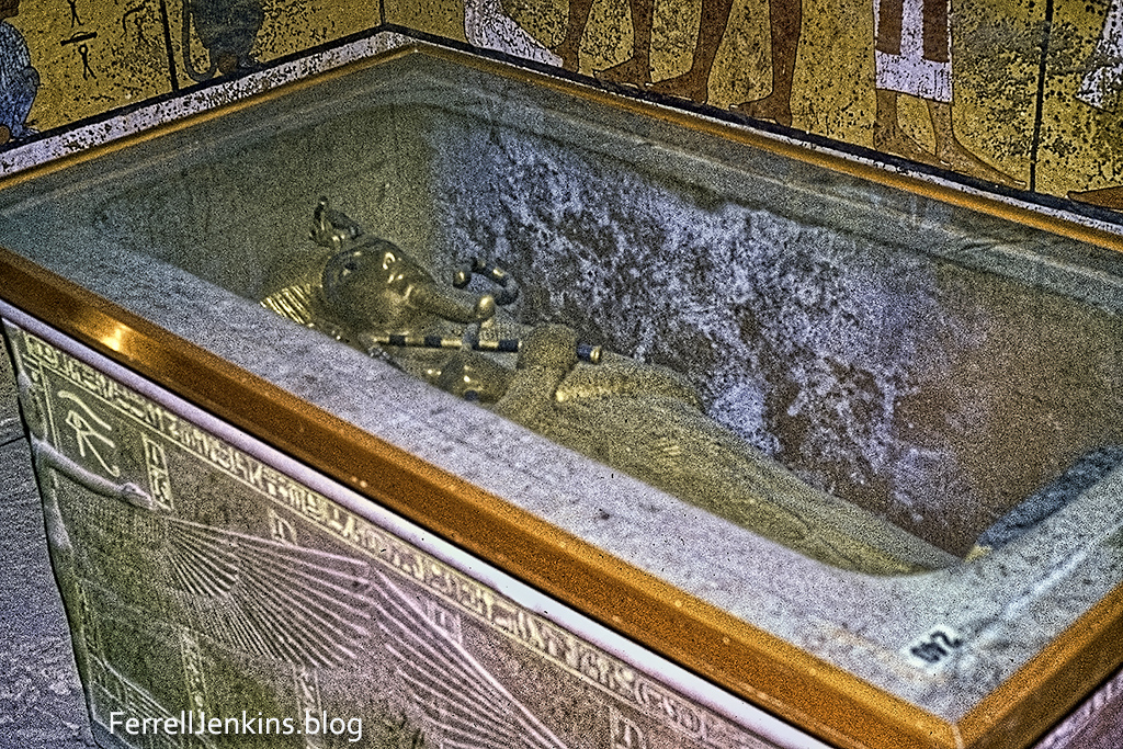
The granite sarcophagus of King Tut in the Valley of the Kings near Luxor. This scan made by Imagers between 1999 and 2004. Photo slide made by Ferrell Jenkins, probably about 1978.

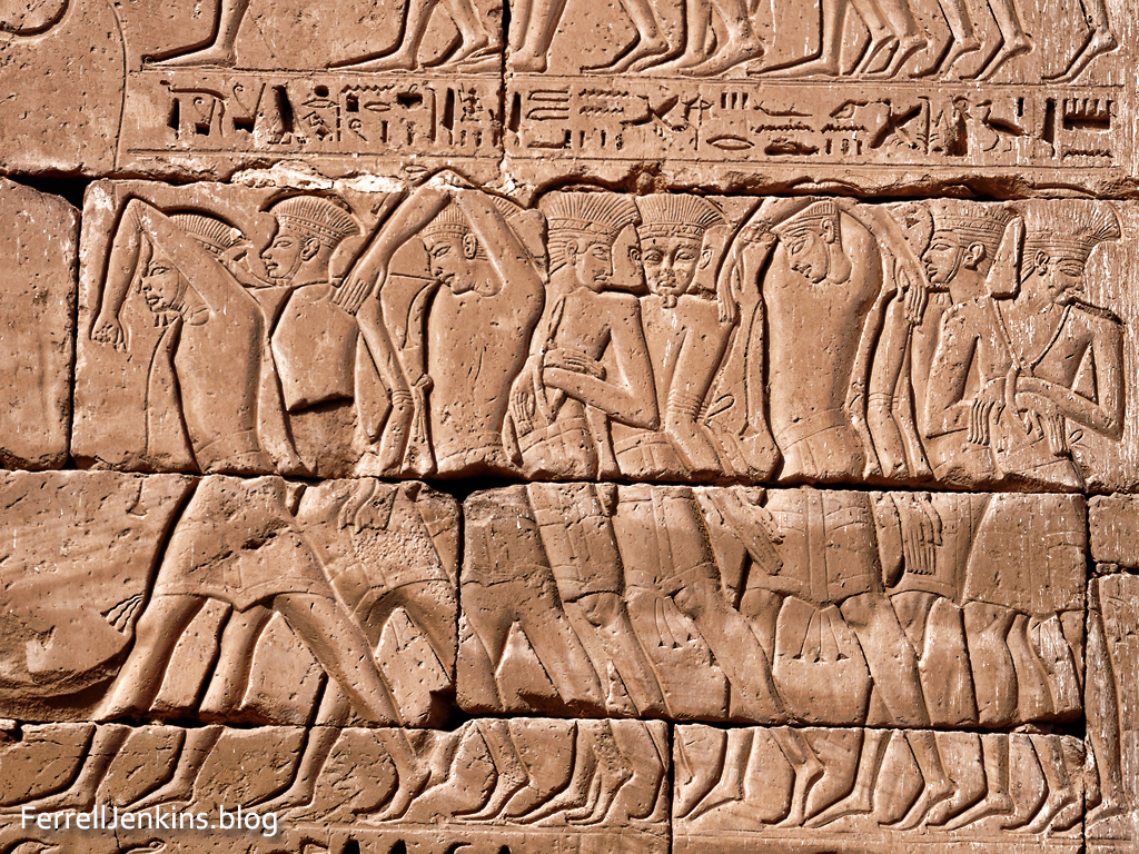
Here is the largest wall painting showing servants of the king serving him in the afterlife. This motif is prominent in many of the tombs.

Wall in King Tut's tomb showing servants caring for his needs in the afterlife.

Slide converted by Imagers between 1999 and 2004/
Photo made by Ferrell Jenkins about 1978.

Bible students recall that Abraham, and later the family of Jacob, spent time in Egypt. This brings us to Moses. He lived more than a century before King Tut and could have become the son of a Pharaoh. Here is the way the writer of Hebrews describes his refusal to be called the son of Pharaoh’s daughter.

By faith Moses, when he was grown up, refused to be called the son of Pharaoh’s daughter, choosing rather to be mistreated with the people of God than to enjoy the fleeting pleasures of sin. He considered the reproach of Christ greater wealth than the treasures of Egypt, for he was looking to the reward. (Heb. 11:24-26 ESV)

The gold face mask of King Tut has been on display in the Cairo Museum every time I have visited.

Face mask of King Tut in the Cairo Museum.

The Face Mask of King Tut displayed in Cairo Museum. Photo by Ferrell Jenkins.

Paul spent a night at Antipatris

The New Testament    site of Antipatris was known as Aphek in Old Testament times. It is the place where the Philistines were encamped when they took the ark of the covenant from the Israelites who had camped at nearby Ebenezer (1 Samuel 4:1).

Antipatris was built by Herod the Great and named in honor of his father Antipater.

Because Aphek/Antipatris sat on a major south-north and west-east routes, it was dominated by many nations. The dominant feature of the site today is the Turkish fort. Inside are the excavated ruins of buildings from Canaanite to Herodian/Roman times.

The 16th century Turkish fortress at Antipatris.
The 16th century Turkish fortress at Aphek-Antipatris, now an Israeli National Park.

Aphek/Antipatris is known by the modern name Ras el-Ain because it is located at the source of the Yarkon River which flows a few miles into the Mediterranean.

Ras al ein, the source of the Yarkon River at Aphek-Antipatris. Photo by Ferrell Jenkins.
Ras al ein, the source of the Yarkon River at Aphek-Antipatris.

When a plot was raised against Paul while he was in the Fortress of Antonia in Jerusalem, he was sent by night to Antipatris. The next day he was escorted to Caesarea Maritima. Luke records the event,

So the soldiers, according to their instructions, took Paul and brought him by night to Antipatris.  And on the next day they returned to the barracks, letting the horsemen go on with him.  When they had come to Caesarea and delivered the letter to the governor, they presented Paul also before him. (Acts 23:31-33 ESV)

A small portion of the Roman cardo, the main East-West road has been uncovered.

From Jerusalem to Antipatris is about 30 miles. From there to Caesarea Maritima is an additional 27 miles.

Paul would remain in custody at Caesarea Maritima for two years. We probably realize that the wheels of power often turn slowly.

The map below is used courtesy of BibleMapper blog.

Map courtesy of BibleMapper.

Courtesy of BibleMapper blog.