Category Archives: Bible Places

Waterfalls of Israel

Tourists often fail to see the waterfalls in Israel because they are hidden in the hills off the main roads and require a hike to get to them. Several years ago I was browsing the books at a profession meeting (SBL) I attended. One of the new publications was The Holman Bible Dictionary (1991). I noticed a photo of the waterfall at Engedi (En Gedi) on page 419. The caption for the photo reads:

The only natural waterfall in Israel is located at Engedi on the west side of the Dead Sea.

I spoke to one of the representatives of the publisher that I had come to know and told him this was a mistake that should be corrected. He thanked me and gave me a copy of the dictionary for having pointed out this error. I assume that future editions of the dictionary have a corrected caption.

Here is a photo of the Jordan River Waterfall (sometimes called the Banias Falls) that I made in 1984. This waterfall is not far from the main road as you leave Banias (Caesarea Philippi) west toward Dan. A place like this would be most refreshing to a person like David as he was fleeing from Saul (1 Samuel 23:29-24:1). Of course, that was at Engedi, in the south.

Jordan River Falls (Banias Falls) Near Caesarea Philippi in Israel. Photo by Ferrell Jenkins 1984.

What really got me to thinking about this today is Todd Bolen’s BiblePlaces Newsletter which came today. In addition to links to news mentioned on the Bible Places Blog, the main feature includes the Waterfalls of Israel. There are five high-resolution photos and a PowerPoint presentation available for download. Todd also mentions other waterfalls in Israel.

Several times before I have recommended the BiblePlaces Newsletter and the Pictorial Library of Bible Lands. Click here to subscribe to the Newsletter. Click here to go to BiblePlaces for information about the Pictorial Library.

The Death of Aaron on Mount Hor

When Aaron, Israel’s first High Priest, died his son Eleazar became the High Priest. The book of Numbers says that Aaron died on the mountain top of Mount Hor.

“Take Aaron and his son Eleazar and bring them up to Mount Hor; and strip Aaron of his garments and put them on his son Eleazar. So Aaron will be gathered to his people, and will die there.” So Moses did just as the LORD had commanded, and they went up to Mount Hor in the sight of all the congregation. After Moses had stripped Aaron of his garments and put them on his son Eleazar, Aaron died there on the mountain top. Then Moses and Eleazar came down from the mountain. When all the congregation saw that Aaron had died, all the house of Israel wept for Aaron thirty days.” (Numbers 20:25-29, NASB).

Deuteronomy records that Aaron died at Moserah (10:6), but it also records that he died on Mount Hor (32:50). We need not think of this as a discrepancy.

The best solution that can be posed to this problem so far is that Moserah is probably a larger area that included Mount Hor. Thus it would be quite correct to declare that Aaron’s death was either on Mount Hor (Num 20:22–29; 33:38–39; Deut 32:50) or Moserah (Deut 10:6). (Hard Sayings of the Bible, 166).

Mount Hor is identified traditionally with Jebel Nebi Harun in the territory of ancient Edom near Petra. From the area of the hotels above Petra one can see the white Moslem shrine marking the tomb of Aaron on the top of Mount Hor. This photo shows the monument in the distance. The mountains reflect the typical color of the area around Petra.

Mount Hor near Petra in Jordan. Photo by Ferrell Jenkins.

“From Dan to Beersheba”

The tribe of Dan was assigned territory along the Mediterranean Sea where Joppa and the modern city of Tel Aviv now stand (Joshua 19:40-48). Because the Philistines lived in this territory the Danites found it necessary to move to a new location. A portion of the tribe moved north to the city of Laish at the foot of Mount Hermon and renamed it Dan (Judges 18). This northern city became the northern boundary of Israelite occupation and prompted the expression “from Dan to Beersheba” (Judges 20:1; 1 Kings 4:25).

An Aramaic inscription was found by Professor Avraham Biran at Dan July 21, 1993. The inscription mentions the king of Israel, the “the house of David,” and the Aramean (Syrian) god of storms and warfare, Hadad. The “house of David” is a reference to the southern kingdom of Judah. Two additional pieces of the inscription were found in June, 1994.

This photo show the partially reconstructed Iron Age (Israelite) gate at Dan.

The Iron Age City Gate at Dan. Photo by Ferrell Jenkins.

Approaching Y20K

When we began this little blog to post photos of our Ancient Crossroads Tour of Biblical and Historical Turkey, we never even thought about reaching 20,000 hits. But, it should happen today. Thanks for making this a site you visit regularly.

There are many things I would like to blog about if I could find the time, but I have basically tried to limit myself to things pertaining to travel in the Bible lands.

As our gift to you for traveling along with us, here is a picture of a woman caring for goats in the Jordan River valley on the east side. This photo was made in the Hashemite Kingdom of Jordan, looking across to Israel. In Roman times (the period of the New Testament) this area was known as Perea. The New Testament never uses the word Perea, but the Greek New Testament has the word peran (translated beyond), in the phrase “beyond the Jordan” (Matthew 19:1; John 1:28; 10:40). Jesus spent a considerable about of time in this region (John 10:40-42; Luke 13:22-35, et al.).

Caring for Goats in the Jordan Valley, the area of Perea in New Testament times. Photo by Ferrell Jenkins.
The desolate looking area across the valley is the northern end of the Wilderness of Judea. The Jordan River is rarely visible because it flows in a depression known as the Zor. The Zor is a depression cut into a wider depression called the Ghor. This valley is several hundred feet below sea level, making it ideal for truck farming today. If that expression (truck farming) is new to you, it means the growing of vegetables for use by people outside the area.
Thanks. Visit often.

“An amazing experience”

An Associated Press report by Anne Gearan is headlined “Bush Visits Biblical Holy Sites.” You may read the entire article here. The article says,

Bush retraced the steps of Jesus and his disciples in the ancient town of Capernaum and gazed out on the nearby Sea of Galilee, where the Bible says Jesus walked on water and calmed a sudden storm by commanding the wind and waves to cease. The waters were crystal blue and calm when Bush visited, leaning in to listen as a brown-robed friar narrated his tour with New Testament passages.

“An amazing experience,” Bush happily said later.

It is an amazing experience for anyone with an interest in the Bible and Jesus. Bush is reported to have said, “I came as a pilgrim.” Many people make pilgrimages to worship at a particular holy site. There is, perhaps, a higher purpose for visiting these sites. On our tours we seek to demonstrate the accuracy of the Bible in describing the Bible land. This involves learning about the geography and topography of the land that help one to better understand the important events that transpired there.

Sunset at Dalmanutha (Mark 8:10) at the northwest corner of the Sea of Galilee. Photo by Ferrell Jenkins.

Sunset at Dalmanutha

The photo above was made at sunset from the site known as Dalmanutha, near the Mount of Beatitudes. Dalmanutha is mentioned only once in the New Testament. After the feeding of the 4000, Mark records that Jesus immediately “entered the boat with His disciples and came to the district of Dalmanutha” (Mark 8:10). In the distance, on the left, you can see the silhouette of Mount Arbel. Then, just to the right of that is the Via Maris (the way to the Mediterranean Sea) from Galilee. The saddle-shaped hill is an extinct volcano known as the Horns of Hattin.

It is “an amazing experience” to visit this land and contemplate these great events.

Selecting a Bible Atlas

A few weeks ago I had a request to recommend a good Bible Atlas. In recent years I have found it difficult to recommend any “good” book unless I have extensive knowledge about the ability of the person making the request, and understand why they need the book. I have more than 15 Bible atlases in my study, and have used others, but no one of them completely satisfies when I get to looking for something special.

Some reader might be thinking, “I have maps in my Bible.” You should either stop reading or continue reading. Maps included in various Bibles can be helpful in seeing a general area, but are of little value in studying details. And, I note that many people have old Bibles that can not have the benefit of the latest research.

So, I have turned to the judgment of someone I trust in this area.

Todd Bolen is Associate Professor of Biblical Studies at the Israel Bible Extension of The Master’s College in Israel. He has been teaching in Israel in the area of biblical archaeology, geography and history for the past ten years, but is currently on leave to continue his studies in the USA. Take a look at his Annotated Bibliography of Selected Books for Israel Studies. Click here.

Among the atlases briefly mentioned are the following:

The Carta Bible Atlas, by Aharoni.
The Moody Atlas of Bible Lands, by Beitzel.
The Holy Land Satellite Atlas, by Cleave.
Student Map Manual: Historical Geography of the Bible Lands, by Monson.
Zondervan NIV Atlas of the Bible, by Rasmussen

Bolen says,

“This [Zondervan NIV Atlas of the Bible] is the atlas to buy to *read* – and therefore is the first choice for a beginning student who can read only one work on the geography of the land. Though the maps are not as extensive or detailed as Macmillan, the text is well-organized, well-written, and trustworthy. The first seventy pages are a geographical overview of the land, region by region. The remaining 130 pages is a historical overview of the lands of the Bible through the biblical periods.”

Bolen also has helpful lists of books on Geography, Old Testament Archaeology, Archaeology Periodicals, Jerusalem Archaeology, New Testament Background, History of Ancient Israel, Modern Israel, et al. The list was last updated October 26, 2007.

On the Bible Places Blog, Bolen comments on “Two New Bible Atlases.” The IVP Atlas of Bible History, by Paul Lawrence, and the Oxford Bible Atlas (4th ed.), by Adrian Curtis.

Here is a review of Carta’s New Century Handbook and Atlas of the Bible. This is an abridgement of The Sacred Bridge. Bolen says,

“Just to be clear, there are many things in this book that I disagree with. If you’re looking for something more conservative, try the NIV Atlas of the Bible, by Carl Rasmussen or the Moody Atlas of Bible Lands, by Barry Beitzel.”

Bolen also has some information on Electronic Maps for Bible Teaching here. Written in 2004, the following works are reviewed or mentioned prominently:

Carta’s Comprehensive Bible Atlas
Bible Maps from Manna
Logos Deluxe Map Set
Nelson’s 3-D Bible Mapbook
Logos Bible Atlas

Below I will list some additional information I have gathered on some other digital sources.

OpenBible.info Bible Atlas (uses satellite photos as the basis of the maps). This includes links to some photos, but many are of no value. Scripture references open to the English Standard Version.

BibleMap. In this program you start with the Bible text to locate places marked on Google satellite maps (photos) or modern road maps. Information from the outdated (1913) International Standard Bible Encyclopedia is also included in the program.

Bible Geocoding claims to contain the location of every identifiable place mentioned in the Bible.

Prof. Mark V. Hoffman writes a blog called Biblical Studies and Technological Tools (From scroll to screen… codex to computer…). Scroll down on the right and click on the label for bible mapping to find information on various digital programs.

American Bible Society has some very nice Interactive Maps in flash format. These would be fine for online study, and it would be great if ABS would make them available in a larger format. The maps require Flash which I was unable to use in Firefox, but I did see the maps in Internet Explorer.

In preaching, and in much teaching, I find that a map showing the general area is adequate for the purpose. I use these various maps in my PowerPoint presentations, but none of these really get at the issue of topography and geography. I use some of the Manna Bible Maps by my friend Matt Hennecke. Scott Richardson, a friend and former student, has prepared some good general purpose Bible Study Maps that I sometimes use in PowerPoint.

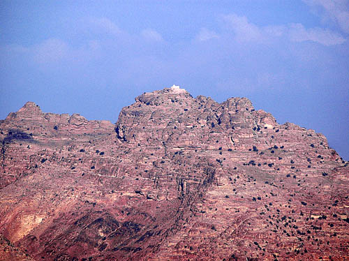
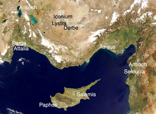
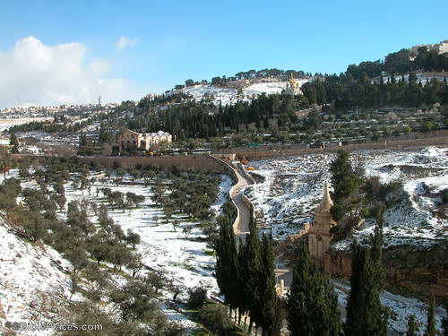
For more detailed work I often use the NASA satellite photos and work up maps that will allow me to show not only the place name, but also the terrain and travel routes. Here is an example of what I am talking about.

Satellite View of Area of Paul’s First Journey

Even though I note that several preachers seem excited about some of the programs using satellite imagery, I wonder if a person who has not visited the lands of the Bible can really use these to good advantage.

Visit BiblicalStudies.Info, click on Scholarly, then Maps of Bible Lands, for some additional sources of maps. These vary in quality but may be useful for some purposes.

Bethlehem and the birth of Jesus

The media is giving its usual Christmas Eve attention to Bethlehem today. The New Testament teaches that Jesus was born in Bethlehem of Judea in the days of Herod the king (Matthew 2:1). The month, day, and year of the birth of Jesus is not stated in the New Testament. We do have some historical information that helps with the date, but not precise information is available (Luke 2).
Do we know the place of the birth of Jesus in Bethlehem? About A.D. 160 Justin Martyr said, “when the child was born in Bethlehem, since Joseph could not find a lodging in that village, he took up his quarters in a certain cave near the village” (Dialogue With Trypho, 78). Near the middle of the third century Origen said that the cave where Jesus was born was being shown and that even the enemies of the faith were talking of it. Jerome was a resident of Bethlehem from A.D. 386 until his death in A.D. 420. He tells how the birthplace of Jesus, the place of the crucifixion and the tomb where Jesus had lain were defiled from the time of Hadrian to the reign of Constantine. The Church of the Nativity now stands at this spot. Of this location, Dalman says:

No one could discern in this former rocky chamber the place of the Nativity. The altar at the east end was perhaps not erected originally to designate the exact spot, although the background of the grotto would make it probable. Here also is the only remarkable feature in it, namely a small adjoining room which contains in the right wall a low niche resembling a manger (Sacred Sites and Ways, 38).

Typical of so many, this site has enjoyed its share of fanciful speculations. Tradition locates the spot where the adoration of the Magi took place and a projection in the background is taken to be the table at which the Virgin ate with the Magi. Like so much speculation, these overlook the fact that the gospel account represents the Magi as arriving at some time after the birth of Jesus and that they found the child with Mary in a “house.” The Wise Men may have had a fast means of transportation, but one should not forget that they traveled by plain, not plane; they came not from the east side of town, but from the East.
This photo shows the exterior of the Church of Nativity in Bethlehem.

Bethlehem - The Church of Nativity

The Church of the Nativity has a long history. It is now a Greek Orthodox church. Underneath the altar is the Grotto of the Nativity where it is said that Jesus was born. Maybe, maybe not. A silver star was set in the marble pavement in 1717. The Latin inscription, “HIC DE VIRGINE MARIA JESUS CHRISTUS NATUS EST.” The translation: “Here Jesus Christ was born of the Virgin Mary.”

Bethlehem - The Church of Nativity - Star in the Grotto of the Nativity

Among the confusion of the date of the birth of Jesus, and the lack of New Testament authority for a church celebration on a certain day, let us not forget that the eternal Word became flesh, and dwelt among men in order to bring salvation to those who obey Him through his death upon the cross (John 1:1, 14; Luke 19:10).

“Although he was a son, he learned obedience through what he suffered. And being made perfect, he became the source of eternal salvation to all who obey him.” – Hebrews 5:8-9, ESV

Where did Noah’s Ark land?

Bible and Spade has made the Fall 2006 issue available in PDF. The entire issue deals with questions of current interest to scholars about the landing of Noah’s Ark. Some recent claims that the ark might have landed in Iran are discussed. The evidence for the two main sites (or regions) in Eastern Turkey are discussed in detail.

One of the main sites is on, or near, Mount Ararat. The mountain is located just a few miles from the Iranian border in eastern Turkey. Here is a photo I made at Mount Ararat earlier in the summer.

Mount Ararat in Eastern Turkey. Photo by Ferrell Jenkins

The other location is Mount Cudi in southeastern Turkey near the border with Iraq. We were unable to visit this site due to the issues between Turkey and the PKK (very much in the news lately).

The Bible says the ark came to rest on the “mountains of Ararat” (Genesis 8:4). Either of these sites fall within that description.

You may download the Fall 2006 issue of Bible and Spade here in PDF (2.0 MB).

Bible and Spade - Fall 2006

I recommend Bible and Spade. I subscribe and have the back issues in Logos Libronix format for easy searching. Go here for more information about subscribing or securing the back issues. Dr. Bryant G. Wood is the editor of Bible and Spade.

Todd Bolen and the BiblePlaces Newsletter

Just when I had about given up,
what to my wondering eyes did appear,
but a BiblePlaces Newsletter with 8 tiny photos of Jerusalem and Judah in Snow. (with apologies to no one!)

When Todd Bolen left Israel to come to the USA to pursue doctoral work I surmised that he would soon become too busy to continue with his Newsletter. He has done a fine job of keeping the Bible Places Blog up to date with notices of important archaeological news from Israel.

I have encouraged many people to subscribe to Todd’s BiblePlaces Newsletter and to buy his wonderful Pictorial Library of Bible Lands. After nearly forty trips to Israel, I still find that I am sometimes lacking the exact photo I need. I often find just the right one in this collection.

In the December BiblePlaces Newsletter there are 8 beautiful photos of Jerusalem and Judah in the snow. Todd was in the country about 10 years and had the opportunity to get photos at the right time.

Here is a small photo of the Mount of Olives and Kidron Valley. From the Newsletter you may download high resolutions copies of all eight photos. For those who use PowerPoint the photos are also available in PowerPoint format.

Mount of Olives and Kidron Valley in Snow

Here is Todd’s comment on the photo:

Looking northeast from the City of David, one gets an impressive view of the Kidron Valley and the Mount of Olives. Several stories occurred within the view of this photo, including David’s fleeing from Absalom (2 Sam 15:30) and Jesus’ crossing the Kidron Valley on his way to Gethsemane (John 18:1). The church in the center left of the photo is built over the traditional Gethsemane and the impressive tomb monument in the lower right is incorrectly known as the “Pillar of Absalom.”

To see the BiblePlaces Newsletter, December, 2007, click here. Opportunity to subscribe to the Newsletter is available at the bottom of the page. You can also learn how to order the Pictorial Library there.

Thanks, Todd. Your work has been a blessing to many.

Christmas, St. Nicholas, and Myra

Christmas is approaching. I would like to call your attention to an article I have written about Christmas. You may read it here. A more detailed outline, The Truth About Christmas, giving both biblical and historical information is available in PDF at BibleWorld.com. You are welcome to duplicate these articles for your own use. Please do not make changes in them.

Even by the end of the first century the church was beginning to move away from the apostolic pattern. One of the earliest departures was in church government. Instead of each church having a plurality of elders (bishops, overseers, pastors) (Acts 14:23; Philippians 1:1), it became popular to elevate one man to the position of Bishop over the elders.

In the fourth century there was a bishop at Myra, by the name of Nicholas, who was benevolent to those in need. From this historical person there arose the legend of Saint Nicholas, eventually Santa Claus.

Myra was a town of Lycia about 85 miles from Antalya, Turkey (biblical Attalia, Acts 14:25). The town is located a few miles away from the Mediterranean, but has a port. When Paul was being escorted by a Roman centurion from Caesarea Maritima to Rome, the ship sailed along the coast of Cilicia and Pamphylia, and landed at Myra in Lycia (Acts 27:5). There they found an Alexandrian ship sailing for Italy.

Whether Paul was close enough to see any of Myra we do not know. There are several interesting things that could have been seen. I have only visited Myra once, in 1987. I mention this to say that it was before the days of digital photos. Here is a photo of the house-type tombs in the cliffs at Myra dating from the 4th century B.C.

Rock Cut Tombs at Myra in Lycia

The theater at Myra dates from the 2nd century B.C., and had a capacity of 10,000 spectators. The following photo comes from the Wikipedia entry on Myra.

Theater at Myra in Lycia

Ruins of the Church of Saint Nicholas can be seen at nearby Demre. Here is a photo I made of the statue of St. Nicholas in 1987.

St. Nicholar at Demre (Myra) in Lycia

And that’s how legend grows!