Tag Archives: Jordan River

Peeking into the Great Rift Valley

The natural depression that runs from northern Syria, through Lebanon, Israel/Jordan, continuing into the Gulf of Eilat/Aqaba, into eastern Africa, is known as the Great Rift. This rift has an important effect on travel and the life of the people of the area — perhaps more in ancient times than now.

This aerial view was made south of Lake Huleh, looking south toward the Sea of Galilee. You can see the Jordan River descending from north to south. Glueck calls this the Jordan Rift.

Jordan Valley north of the Sea of Galilee. Photo by Ferrell Jenkins.

The Jordan Valley north of the Sea of Galilee. Photo by Ferrell Jenkins.

The elevation at Lake Huleh is 230 feet above sea level. By the time the Jordan River flows into the Sea of Galilee, ten miles south, the elevation of about 700 feet below sea level. This is the area of most rapid descent.

Nelson Glueck describes this portion of the Jordan River.

…it tears out on a run that, for some distance, brooks no restraint. It tumbles and cascades almost continuously through a forbidding, black basalt gorge. Foaming and muddy, it bursts out of the ravine. Then, collecting itself somewhat, it wriggles its way for about another mile through a small plain and a delta of its own making into the clear waters of the Lake of Galilee. (The Jordan River, 35)

Jordan River baptism site reported to be open

Several media outlets have reported the permanent opening of the Qasr el-Yahud Baptismal site. Our group made arrangements to visit the site May 3, but we had to wait for military personnel to open the gate. Some construction work was going on, and the road to the site needed repair. See here. See earlier reports here, and here.

Some reports have warned about the impurity of the water. I advised my group not to touch it. A group of Ethiopians were dipping themselves, dipping others, and pouring water on themselves while we were there. A hand full of water looked like mud as it left the hand.

Ethiopians in the Jordan River at Qasr el-Jahud. Photo by Ferrell Jenkins.

Ethiopians in the Jordan River at Qasr el-Yahud. Photo by Ferrell Jenkins.

Personally I understand baptism to be a one-time act “for the forgiveness of your sins” (Acts 2:28; 8:12; Matthew 28:19; Mark 16:16; Romans 6:3-4; et al.).

Bible students like to visit the Jordan River at this site for several reasons.

  • Ancient Israel crossed the Jordan to enter the promised land (Joshua 3).
  • Elijah and Elisha crossed the river (2 Kings 2).
  • John baptized in the Jordan (Matthew 3:6ff.; Mark 1:5-9; John 1:28; 10:40).
  • Jesus was baptized in the Jordan (Matthew 3:13).
  • Naaman dipped in the Jordan at a site further north (2 Kings 5).

The view was made from the West Bank site looking northeast. A group of western pilgrims are visible on the (Hashemite Kingdom of) Jordan side of the river.

Jordan River Baptismal Site. Photo by Ferrell Jenkins.

Jordan River Baptismal Site. View to the NE. Photo by Ferrell Jenkins.

HT: Bible Places Blog.

The flea river: Nahr Bareighit or Nahal Iyon

The least known of the sources of the Jordan River is the Nahr Bareighit (flea river) or Nahal Iyon (the name used in Israel). Like the Senir (Hasbani), this river begins in the Beka Valley of Lebanon. It is often overlooked when the sources of the Jordan are named.

Nelson Glueck, The River Jordan, describes the Nahr Bareighit.

The westernmost source of the Jordan is the small mountain stream, Nahr Bareighit. Through a rude gorge, it tumbles down southward from the hilly meadowland of Merj ‘Ayun, which retains in clear part its ancient Biblical name of Ijon (1 Kings 15:20), to add its waters to the formation of the fateful [Jordan] river. The Nahr Bareighit joins the Nahr Hasbani about three quarters of a mile above the point where the Hasbani joins the junction of the Leddan and Banias streams. These last two alone were anciently considered as the sole sources of the Jordan. All found help to form it, and lose their identity in it, as the Jordan starts it flow under its own name.

“Roll, Jordan, roll;
I want to go to heaven when I die
To hear sweet Jordan roll.”

Deni Baly, The Geography of the Bible, devotes a single sentence to this little stream.

The basin of Marj ‘Ayoun to the west is drained by the smaller Bareighit, which leaps over the threshold in a series of charming waterfalls near Metullah and postpones its junction with the Jordan until just before the Huleh marshes. (193)

The photo below shows the Iyon Mill Falls. It is one of the beautiful photos of several falls on the river from the Pictorial Library of Bible Lands. Check BiblePlaces.com to purchase the complete set or the DVD of Galilee and the North.

Nahal Iyon Mill Falls. Photo: BiblePlaces.com.

Nahal Iyon Mill Falls. Photo courtesy of BiblePlaces.com.

Favorite photo of 2008?

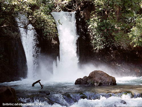
Elizabeth and I were driving from lunch today when I asked her what she thought would be my favorite photo of 2008. That excludes the grandson, of course. After some discussion we both agreed that it was a difficult decision. She suggested the En Gedi waterfall. Good suggestion. We posted one of those photos here. I debated about posting a different view, but then decided to go with another choice.

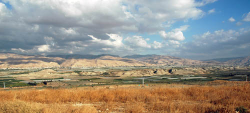
Early in the year I posted a 1984 photo of the Jordan River waterfall here. In April, while my group was eating lunch at Banias, the site of Caesarea Philippi, I broke away with David Padfield to visit the nearby Jordan Waterfall. The fall is also known as the Banias Waterfall. In order for this photo be understood it might be good if I showed you a photo of the surrounding terrain.

The photo below was made from above the waterfall. The waterfall is in the depression to the left of the rocky area; you are seeing the top of large trees. Caesarea Philippi is between the two closest hills. The Banias River begins as a spring there and soon cuts its way into the surrounding earth and rock. It is not really the Jordan until it joins with other sources, including the Dan River.

Vicinity of the Jordan River Waterfall. Photo by Ferrell Jenkins.

Vicinity of the Jordan River Waterfall. Photo by Ferrell Jenkins.

Once we make our way down into the depression among the trees we see the beautiful waterfall.

Jordan River Waterfall. Photo by Ferrell Jenkins.

Jordan River Waterfall. Photo by Ferrell Jenkins.

On my first trip in 1967 it was impossible to visit either the source of the river or the waterfall because it was within Syria. After Israel captured the territory, it became possible to make the visit.

Was this absolutely my favorite photo of 2008? Probably not. I was blessed to visit Israel (twice), Jordan, Turkey, Greece and the Greek islands. There were too many favorites to make a choice.

Matthew uses the term district or region to describe the area Jesus visited with His disciples (Matthew 16:13). The Kings James Version coasts is misleading. Mark’s term is villages (Mark 8:27). It was not far from here that Jesus was confessed as the Christ by Peter.

Jesus went out, along with His disciples, to the villages of Caesarea Philippi; and on the way He questioned His disciples, saying to them, “Who do people say that I am?”  They told Him, saying, “John the Baptist; and others say Elijah; but others, one of the prophets.” And He continued by questioning them, “But who do you say that I am?” Peter answered and said to Him, “You are the Christ.” (Mark 8:27-29 NASB; also read Matthew’s account)

Pictures of Adam?

The title could be misleading. It could be like all of those drawings showing John the Baptist pouring water over the head of Jesus. The Adam we speak of is a place mentioned in the account of the Israelite crossing of the Jordan River.

the waters which were flowing down from above stood and rose up in one heap, a great distance away at Adam, the city that is beside Zarethan; and those which were flowing down toward the sea of the Arabah, the Salt Sea, were completely cut off. So the people crossed opposite Jericho. (Joshua 3:16)

Our fellow-blogger over at Aantekeningen bij de Bijbel in the Netherlands asks,

Do you have also pictures from the Jordan in the neighbourhood of Adam? The place where the Jordan was halted for some time?

To my knowledge It is not possible to approach the Jordan except an area between the Sea of Galilee and Beth-shan, and at Bethany Beyond the Jordan. Photos are not allowed at the various military check points.

The best I can do is to show you a photo I made in November of 2005. This photo is looking east toward the mountains of Gilead. I think the rift to the right of the middle of the photo is the Jabbok Valley. Adam would be located somewhere to the right in this photo. If some other reader can be more specific I would be happy to know.

The fence in the foreground of the photo is the boundary between Israel (West Bank area) and Jordan. I often describe the Jordan River as being shy. All along the Jordan Rift, one only sees the River at a place or two. The Jordan flows in the green area in the bottom of the rift. All of the white horizontal lines in the photo are hot houses use for growing agricultural produce.

The Jordan River

The distance from the principal source of the Jordan at the foot of Mt. Hermon to the northern end of the Dead Sea is about 135 miles, but the serpent-like Jordan flows over 200 miles. At the source, the elevation is about 1150 feet above sea level. By the time the river reaches the Sea of Galilee it is about 700 feet below sea level, and when it reaches the Dead Sea it is more than 1300 feet below sea level. These and other unusual physical characteristics make the Jordan a significant river. To the Bible student the importance of the river is found in the events which transpired in it.

Israel crosses the Jordan. The children of Israel crossed the Jordan when the water was out of all its banks during the time of harvest (Josh. 3:15). An American reader might think of this as the fall of the year, but actually it was in the spring, at the time of the latter rain (Joel 2:23). As spring approached in Bible times the Jordan would overflow its banks due to the heavy latter rains (about early April) and the melting snows of Mount Hermon. Conditions are different in modern times. Water that once flowed south from the Sea of Galilee and from tributaries such as the Yarmuk River is now used for irrigation. This makes the Jordan much smaller than in earlier times. The crossing of the Jordan by the Israelites provided the imagery for our hymn, “On Jordan’s Stormy Banks I Stand.”

Elijah and Elisha. Both of these oral prophets crossed the Jordan on dry ground prior to Elijah=s being taken up by a whirlwind into heaven. Elisha later used the mantle of Elijah which had fallen upon him to smite the Jordan so that he was able to return (2 Kings 2:8-14).

Naaman the leper. Naaman, captain of the army of the king of Aram, was told by the prophet Elisha to wash seven times in the Jordan to be cleansed of his leprosy. For a reason not explicitly given, Naaman complained that the Abanah and Pharpar, the rivers of Damascus, were better than all the waters of Israel. When he eventually obeyed the Lord, he was made clean (2 Kings 5:1-14). We understand that it was not in the properties of the water but by the power of the Lord that Naaman was made clean through his obedience.

John and Jesus. John immersed in the Jordan River (Mt. 3:1-6). The last important biblical event and the crowning glory of the Jordan was the baptism of Jesus (Mt. 3:13-17).

Photographs of the Jordan south of the Sea of Galilee have been difficult to make since 1967 because the river has served, more or less, as the boundary between Israel (or the occupied West Bank) and Jordan. This photograph was made at the site across from Jericho that may be identified as “Bethany beyond the Jordan” (John 1:28), where John the Baptist baptized at first (John 10:40).

Waterfalls of Israel

Tourists often fail to see the waterfalls in Israel because they are hidden in the hills off the main roads and require a hike to get to them. Several years ago I was browsing the books at a profession meeting (SBL) I attended. One of the new publications was The Holman Bible Dictionary (1991). I noticed a photo of the waterfall at Engedi (En Gedi) on page 419. The caption for the photo reads:

The only natural waterfall in Israel is located at Engedi on the west side of the Dead Sea.

I spoke to one of the representatives of the publisher that I had come to know and told him this was a mistake that should be corrected. He thanked me and gave me a copy of the dictionary for having pointed out this error. I assume that future editions of the dictionary have a corrected caption.

Here is a photo of the Jordan River Waterfall (sometimes called the Banias Falls) that I made in 1984. This waterfall is not far from the main road as you leave Banias (Caesarea Philippi) west toward Dan. A place like this would be most refreshing to a person like David as he was fleeing from Saul (1 Samuel 23:29-24:1). Of course, that was at Engedi, in the south.

Jordan River Falls (Banias Falls) Near Caesarea Philippi in Israel. Photo by Ferrell Jenkins 1984.

What really got me to thinking about this today is Todd Bolen’s BiblePlaces Newsletter which came today. In addition to links to news mentioned on the Bible Places Blog, the main feature includes the Waterfalls of Israel. There are five high-resolution photos and a PowerPoint presentation available for download. Todd also mentions other waterfalls in Israel.

Several times before I have recommended the BiblePlaces Newsletter and the Pictorial Library of Bible Lands. Click here to subscribe to the Newsletter. Click here to go to BiblePlaces for information about the Pictorial Library.

Approaching Y20K

When we began this little blog to post photos of our Ancient Crossroads Tour of Biblical and Historical Turkey, we never even thought about reaching 20,000 hits. But, it should happen today. Thanks for making this a site you visit regularly.

There are many things I would like to blog about if I could find the time, but I have basically tried to limit myself to things pertaining to travel in the Bible lands.

As our gift to you for traveling along with us, here is a picture of a woman caring for goats in the Jordan River valley on the east side. This photo was made in the Hashemite Kingdom of Jordan, looking across to Israel. In Roman times (the period of the New Testament) this area was known as Perea. The New Testament never uses the word Perea, but the Greek New Testament has the word peran (translated beyond), in the phrase “beyond the Jordan” (Matthew 19:1; John 1:28; 10:40). Jesus spent a considerable about of time in this region (John 10:40-42; Luke 13:22-35, et al.).

Caring for Goats in the Jordan Valley, the area of Perea in New Testament times. Photo by Ferrell Jenkins.
The desolate looking area across the valley is the northern end of the Wilderness of Judea. The Jordan River is rarely visible because it flows in a depression known as the Zor. The Zor is a depression cut into a wider depression called the Ghor. This valley is several hundred feet below sea level, making it ideal for truck farming today. If that expression (truck farming) is new to you, it means the growing of vegetables for use by people outside the area.
Thanks. Visit often.