Tag Archives: Bible Atlas

A synagogue on the island of Delos

In the previous post we mentioned that there were numerous synagogues used by Jews of the Diaspora. Paul visited synagogues in many of the cities where he preached.

During his Spring travels, Dr. Carl Rasmussen visited the Greek island of Delos. Delos is one of those places that can only be reached with much effort. Carl has graciously granted permission for me to use a couple of his photos here. The first one shows a view to the west, southwest, showing various rooms of the synagogue. Note the “Moses Seat” in the upper right of the photo. The entrance is visible in the lower left.

Delos synagogue. Photo by HolyLandPhotos.

Delos synagogue. Photo by Carl Rasmussen, HolyLandPhotos.

The second photo shows a close up of the “Moses Seat” and the marble seats on each side. You may click on the photos for larger images provided by Dr. Rasmussen at the HolyLandPhotos’ Blog.

Delos synagogue. Photo by Carl Rasmussen, HolyLandPhotos.

Delos synagogue. Photo by Carl Rasmussen, HolyLandPhotos.

This large synagogue dates to the mid-second century B.C. Two inscriptions found in 1979-80 indicate that the worshipers here (Israelites) were likely Samaritans who revered Argarizein (Mount Gerizim). (See Kraabel, “New Evidence of the Samaritan Diaspora has been Found on Delos.” BA 47:1; 1984).

The Moses Seat. We commonly identify a special seat like the one in this synagogue as the Seat of Moses. Jesus may have made reference to such a seat (Matthew 23:2-3). For more information about the “Moses Seat” see here. Michael White suggests at least the possibility that this seat may be a “Proedrion, either for the major donor (or patron) or for the leader of the group” (HTR 80:2 (1987). I don’t see that this changes the fact that a reader and teacher of the Law might sit here.

If you have any interest in the synagogues scattered over the Mediterranean world, you will want to visit the HolyLandPhotos’ Blog here.

Tradition has it that Delos is the birthplace of Apollo, the son of Zeus, and his twin sister Artemis.

Marble head of Apolls from Perga. Second century A.D. Photo by Ferrell Jenkins.

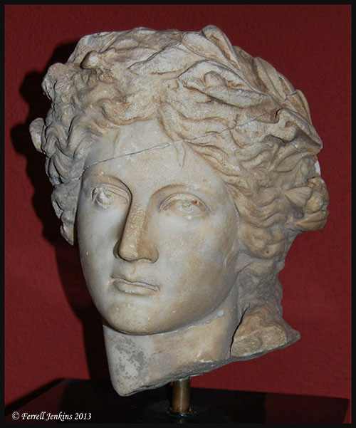
Marble head of Apolls from Perga. Second century A.D. Photo by Ferrell Jenkins in the Antalya Archaeological Museum.

An article by Gordon Franz a few years ago piqued my interest in Delos. He wrote on “The Synagogue On The Island Of Delos And The Epistle Of James” in Bible and Spade (18:3; 2005). Franz provides the history and geography of the island. He includes a photo of the “Samaritan inscription,” and then proceeds to use the synagogue of Delos to illustrate two passages from the Epistle of James. He discusses James 2:2-4 and selected verses from James 3.

For those who have an interest in visiting Delos, Prof. Rasmussen explains exactly how to reach the synagogue from the Delos Museum. Rasmussen is author of the Zondervan Atlas of the Bible, and provides nearly 4000 thousand photos at the Holy Land Photos archive.

Limited time bargain on a great Bible atlas

Christianbook.com is offering Carl Rasmussen’s Zondervan Atlas of the Bible for a limited time at the unusual price of $14.99. Click here.

zondervanatlascover01

I can’t promise that it will still be available by the time I get this posted, but you can try.

Update Noon  12-04-12:  I see the price is now $19.99. If you have a a Prime account with Amazon (postage free), or wish to add another item, the price may be better at $22.73 for Zondervan Atlas of the Bible.

This Atlas is an extremely good one. It is well written, accurate, colorful, filled with great photos and helpful maps. Earlier this evening I emailed a notice to folks who have traveled with me recently, or who plan to, with this note:

This is an excellent book for anyone planning a tour to Israel, or anyone who has been. It should be one of your most helpful Bible study tools.

One of the ladies who traveled to Israel earlier this year replied with this note:

That is a great price. I got one before we went. I use it daily as I read and it sure brings the scriptures alive. It is much more so now that we have seen the country.

Photos that are worth 1000 words each

Photos can be used effectively to illustrate Bible lands and customs. Otherwise dull presentations can come to life with the use and explanation of appropriate photos.

Pictorial Library of Bible Lands. We have suggested frequently that every Bible teacher needs access to Todd Bolen’s Pictorial Library of Bible Lands. Todd publishes a Newsletter every few months in which he gives away a few excellent photos already in PowerPoint format. If you don’t receive the Newsletter I suggest you download the November issue here. It contains several panoramic photos that give you the opportunity to see and understand a lot at once. And while you are there you should sign up to receive the Newsletter when it is published. Also take a look at the BiblePlaces Blog and the BiblePlaces.com web site. See also LifeintheHolyLand.com. BiblePaces is now availabe in French at BibleLieux.com and Spanish at LugaresBiblicos.com.

Holy Land Photos. Carl G. Rasmussen, author of the revised Zondervan Atlas of the Bible, is now posting the photos used in the Atlas at his Holy Land Photos site. Begin here. You will find thousands of useful photos at this site. These photos will be especially helpful to those seeking to teach Bible geography or to incorporate geographical information into lessons. These photos are in PowerPoint format. You also need the have and study the Atlas. Also check the HolyLandPhotosBlog for more recent photos and updates.

Order the Zondervan Atlas of the Bible from Amazon (currently $26.12).

David Padfield has a large number of photos of Bible lands available for free download here. Thanks to these men who have devoted much time and money to acquiring the photos and preparing them for others to use. I have used the work of all three in my presentations in recent years.

A New, Smaller Bible Atlas

Carta's New Century Handbook and Atlas of the Bible

Carta’s New Century Handbook and Atlas of the Bible
Abridgment of The Sacred Bridge

by Anson F. Rainey and R. Steven Notley
Carta, Jerusalem, 2007
280 pages + full color illustrations and maps, English. Cloth, 9 x 12 inches
ISBN: 9789652207036
List Price: $50.00. Your Price: $45.00

Several times we have mentioned the important of the Bible student having a good atlas. Check here. Two years ago Carta brought out The Sacred Bridge, by Rainey and Notley. The book is large, and the content is more than most students want or need. And the price was $100. In response to a request from many professors, the same authors have prepared Carta’s New Century Handbook and Atlas of the Bible. I have not seen this book, but I have been using the larger atlas, and I plan to get a copy of the abridged edition. Fortunately I was able to get The Sacred Bridge autographed by Rainey and Notley.

Eisenbrauns is the US distributor of Carta books and maps. A click on the title at the top will take you to their web page.

Selecting a Bible Atlas

A few weeks ago I had a request to recommend a good Bible Atlas. In recent years I have found it difficult to recommend any “good” book unless I have extensive knowledge about the ability of the person making the request, and understand why they need the book. I have more than 15 Bible atlases in my study, and have used others, but no one of them completely satisfies when I get to looking for something special.

Some reader might be thinking, “I have maps in my Bible.” You should either stop reading or continue reading. Maps included in various Bibles can be helpful in seeing a general area, but are of little value in studying details. And, I note that many people have old Bibles that can not have the benefit of the latest research.

So, I have turned to the judgment of someone I trust in this area.

Todd Bolen is Associate Professor of Biblical Studies at the Israel Bible Extension of The Master’s College in Israel. He has been teaching in Israel in the area of biblical archaeology, geography and history for the past ten years, but is currently on leave to continue his studies in the USA. Take a look at his Annotated Bibliography of Selected Books for Israel Studies. Click here.

Among the atlases briefly mentioned are the following:

The Carta Bible Atlas, by Aharoni.
The Moody Atlas of Bible Lands, by Beitzel.
The Holy Land Satellite Atlas, by Cleave.
Student Map Manual: Historical Geography of the Bible Lands, by Monson.
Zondervan NIV Atlas of the Bible, by Rasmussen

Bolen says,

“This [Zondervan NIV Atlas of the Bible] is the atlas to buy to *read* – and therefore is the first choice for a beginning student who can read only one work on the geography of the land. Though the maps are not as extensive or detailed as Macmillan, the text is well-organized, well-written, and trustworthy. The first seventy pages are a geographical overview of the land, region by region. The remaining 130 pages is a historical overview of the lands of the Bible through the biblical periods.”

Bolen also has helpful lists of books on Geography, Old Testament Archaeology, Archaeology Periodicals, Jerusalem Archaeology, New Testament Background, History of Ancient Israel, Modern Israel, et al. The list was last updated October 26, 2007.

On the Bible Places Blog, Bolen comments on “Two New Bible Atlases.” The IVP Atlas of Bible History, by Paul Lawrence, and the Oxford Bible Atlas (4th ed.), by Adrian Curtis.

Here is a review of Carta’s New Century Handbook and Atlas of the Bible. This is an abridgement of The Sacred Bridge. Bolen says,

“Just to be clear, there are many things in this book that I disagree with. If you’re looking for something more conservative, try the NIV Atlas of the Bible, by Carl Rasmussen or the Moody Atlas of Bible Lands, by Barry Beitzel.”

Bolen also has some information on Electronic Maps for Bible Teaching here. Written in 2004, the following works are reviewed or mentioned prominently:

Carta’s Comprehensive Bible Atlas
Bible Maps from Manna
Logos Deluxe Map Set
Nelson’s 3-D Bible Mapbook
Logos Bible Atlas

Below I will list some additional information I have gathered on some other digital sources.

OpenBible.info Bible Atlas (uses satellite photos as the basis of the maps). This includes links to some photos, but many are of no value. Scripture references open to the English Standard Version.

BibleMap. In this program you start with the Bible text to locate places marked on Google satellite maps (photos) or modern road maps. Information from the outdated (1913) International Standard Bible Encyclopedia is also included in the program.

Bible Geocoding claims to contain the location of every identifiable place mentioned in the Bible.

Prof. Mark V. Hoffman writes a blog called Biblical Studies and Technological Tools (From scroll to screen… codex to computer…). Scroll down on the right and click on the label for bible mapping to find information on various digital programs.

American Bible Society has some very nice Interactive Maps in flash format. These would be fine for online study, and it would be great if ABS would make them available in a larger format. The maps require Flash which I was unable to use in Firefox, but I did see the maps in Internet Explorer.

In preaching, and in much teaching, I find that a map showing the general area is adequate for the purpose. I use these various maps in my PowerPoint presentations, but none of these really get at the issue of topography and geography. I use some of the Manna Bible Maps by my friend Matt Hennecke. Scott Richardson, a friend and former student, has prepared some good general purpose Bible Study Maps that I sometimes use in PowerPoint.

For more detailed work I often use the NASA satellite photos and work up maps that will allow me to show not only the place name, but also the terrain and travel routes. Here is an example of what I am talking about.

Satellite View of Area of Paul’s First Journey

Even though I note that several preachers seem excited about some of the programs using satellite imagery, I wonder if a person who has not visited the lands of the Bible can really use these to good advantage.

Visit BiblicalStudies.Info, click on Scholarly, then Maps of Bible Lands, for some additional sources of maps. These vary in quality but may be useful for some purposes.