Tenth century B.C. inscription found in Jerusalem

Hebrew University announces another significant archaeological discovery today. The entire press release is below.

 —• —

Jerusalem, July 10, 2013 — Working near the Temple Mount in Jerusalem, Hebrew University of Jerusalem archaeologist Dr. Eilat Mazar has unearthed the earliest alphabetical written text ever uncovered in the city.

Dr. Eilat Mazar with Canaanite inscription.

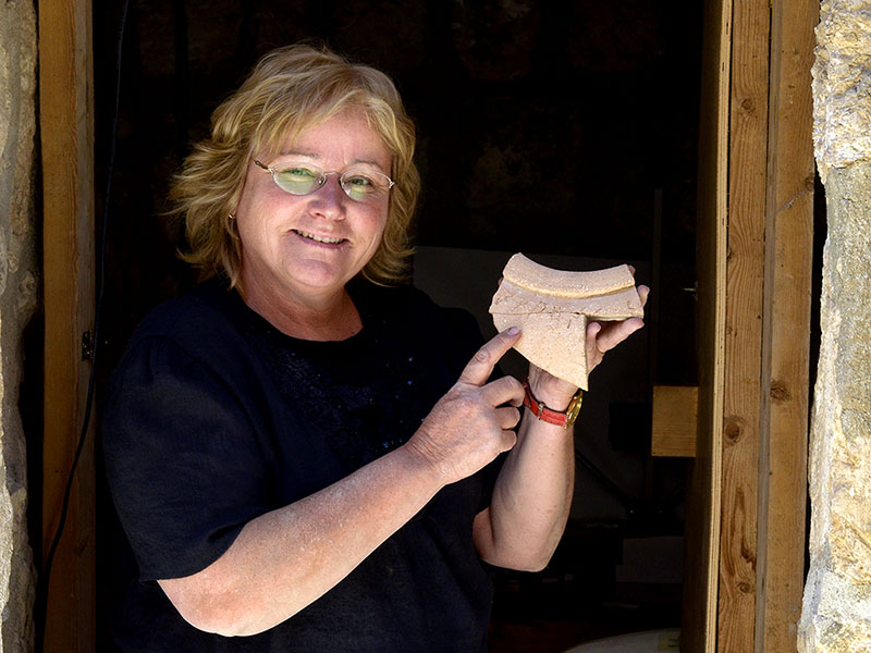
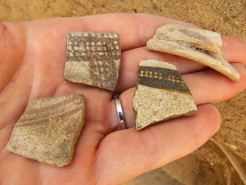
Hebrew University of Jerusalem archaeologist Dr. Eilat Mazar displays a jar fragment unearthed near Jerusalem’s Temple Mount bearing an inscription in the Canaanite language. Dated to the tenth century BCE, it is the earliest alphabetical written text ever uncovered in the city. (Photo courtesy of Dr. Eilat Mazar; photographed by Oria Tadmor.)

The inscription is engraved on a large pithos, a neckless ceramic jar found with six others at the Ophel excavation site. According to Dr. Mazar, the inscription, in the Canaanite language, is the only one of its kind discovered in Jerusalem and an important addition to the city’s history.

Canaanite inscription excavated by Dr. Eilat Mazar.

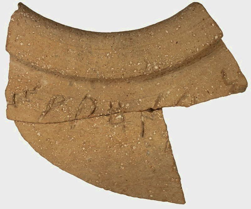
This jar fragment bearing an inscription in the Canaanite language was unearthed near Jerusalem’s Temple Mount by Hebrew University archaeologist Dr. Eilat Mazar. Dated to the tenth century BCE, it is the earliest alphabetical written text ever uncovered in the city. (Photo courtesy of Dr. Eilat Mazar; photographed by Noga Cohen-Aloro.)

Dated to the tenth century BCE, the artifact predates by two hundred and fifty years the earliest known Hebrew inscription from Jerusalem, which is from the period of King Hezekiah at the end of the eighth century BCE.

A third-generation archaeologist working at the Hebrew University’s Institute of Archaeology, Dr. Mazar directs archaeological excavations on the summit of the City of David and at the southern wall of the Temple Mount.

The discovery will be announced in a paper by Dr. Mazar, Prof. Shmuel Ahituv of Ben-Gurion University of the Negev, and Dr. David Ben-Shlomo of the Hebrew University, following their extensive research on the artifact. Prof. Ahituv studied the inscription and Dr. Ben-Shlomo studied the composition of the ceramic materials. The paper, “An Inscribed Pithos From the Ophel,” appears in the Israel Exploration Journal 63/1 (2013).

The inscription was engraved near the edge of the jar before it was fired, and only a fragment of it has been found, along with fragments of six large jars of the same type. The fragments were used to stabilize the earth fill under the second floor of the building they were discovered in, which dates to the Early Iron IIA period (10th century BCE).  An analysis of the jars’ clay composition indicates that they are all of a similar make, and probably originate in the central hill country near Jerusalem.

According to Prof. Ahituv, the inscription is not complete and probably wound around the jar’s shoulder, while the remaining portion is just the end of the inscription and one letter from the beginning. The inscription is engraved in a proto-Canaanite / early Canaanite script of the eleventh-to-tenth centuries BCE, which pre-dates the Israelite rule and the prevalence of Hebrew script.

Reading from left to right, the text contains a combination of letters approximately 2.5 cm tall, which translate to m, q, p, h, n, (possibly) l, and n. Since this combination of letters has no meaning in known west-Semitic languages, the inscription’s meaning is unknown.

The archaeologists suspect the inscription specifies the jar’s contents or the name of its owner. Because the inscription is not in Hebrew, it is likely to have been written by one of the non-Israeli residents of Jerusalem, perhaps Jebusites, who were part of the city population in the time of Kings David and Solomon.

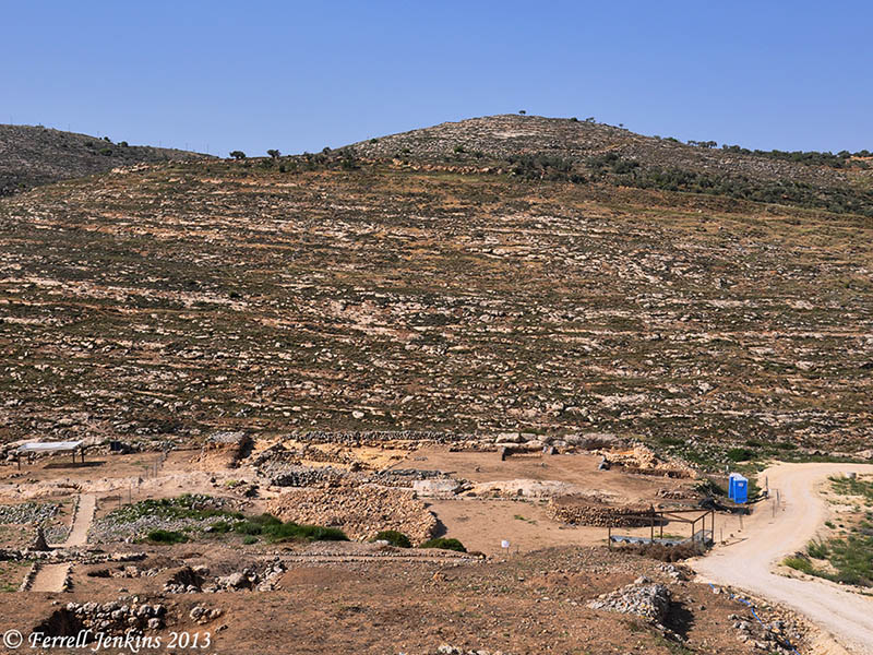
Excavations at the site are conducted in collaboration with the Israel Antiquities Authority, the Israel Nature and Parks Authority, and the East Jerusalem Development Company. The site is in the national park surrounding the walls of Jerusalem’s Old City, near the southern wall of the Temple Mount compound. The Israel Antiquities Authority maintains the excavation site as a national park open to the public.

The excavations are made possible through a generous donation by Daniel Mintz and Meredith Berkman of New York. Participants in the dig include Israeli students and workers, along with students or alumni of Herbert W. Armstrong College sent to Jerusalem from Edmond, Oklahoma to participate in the excavation.

HT: Joseph I. Lauer

Egyptian sphinx fragment found at Hazor

The Hebrew University of Jerusalem announced today the discovery at Hazor of a sphinx fragment of Pharaoh Mycerinus. Mycerinus is the builder of the smallest of the three great pyramids of Giza in Egypt. The photo below was made facing east toward the Nile Valley. The pyramid of Mycerinus is on the right. The pyramid, built about 2500 B.C., is 204 feet high.

The pyramids of Giza" Cheolps, Chephren, and Mycerinus (left to right). Photo by Ferrell Jenkins.

Pyramids of Giza: Cheops, Chephren, & Mycerinus (left to right). Photo: Ferrell Jenkins.

The press release from Jerusalem says,

At a site in Tel Hazor National Park, north of the Sea of Galilee, archeologists from the Hebrew University of Jerusalem have unearthed part of a unique Sphinx belonging to one of the ancient pyramid-building pharaohs.

The Hazor Excavations are headed by Prof. Amnon Ben-Tor, the Yigael Yadin Professor in the Archaeology of Eretz Israel at the Hebrew University’s Institute of Archaeology, and Dr. Sharon Zuckerman, a lecturer at the Hebrew University’s Institute of Archaeology.

Prof. Amnon Ben-Tor and Dr. Sharon Zuckerman of the Hebrew University’s Institute of Archaeology, who are leading the Hazor Excavations (Photo courtesy archaeologists Prof. Amnon Ben-Tor and Dr. Sharon Zuckerman)

Prof. Amnon Ben-Tor and Dr. Sharon Zuckerman of the Hebrew University’s Institute of Archaeology, who are leading the Hazor Excavations (Photo courtesy archaeologists Prof. Amnon Ben-Tor and Dr. Sharon Zuckerman)

Working with a team from the Institute of Archaeology, they discovered part of a Sphinx brought over from Egypt, with a hieroglyphic inscription between its front legs. The inscription bears the name of the Egyptian king Mycerinus, who ruled in the third millennium BCE, more than 4,000 years ago. The king was one of the builders of the famous Giza pyramids.

As the only known Sphinx of this king discovered anywhere in the world — including in Egypt — the find at Hazor is an unexpected and important discovery. Moreover, it is only piece of a royal Sphinx sculpture discovered in the entire Levant area (the eastern part of the Mediterranean).

Along with the king’s name, the hieroglyphic inscription includes the descriptor “Beloved by the divine manifestation… that gave him eternal life.” According to Prof. Ben-Tor and Dr. Zuckerman, this text indicates that the Sphinx probably originated in the ancient city of Heliopolis (the city of ‘On’ in the Bible), north of modern Cairo.

The Sphinx was discovered in the destruction layer of Hazor that was destroyed during the 13th century BCE, at the entrance to the city palace. According to the archaeologists, it is highly unlikely that the Sphinx was brought to Hazor during the time of Mycerinus, since there is no record of any relationship between Egypt and Israel in the third millennium BCE.

More likely, the statue was brought to Israel in the second millennium BCE during the dynasty of the kings known as the Hyksos, who originated in Canaan. It could also have arrived during the 15th to 13th centuries BCE, when Canaan was under Egyptian rule, as a gift from an Egyptian king to the king of Hazor, which was the most important city in the southern Levant at the time.

Hazor is the largest biblical-era site in Israel, covering some 200 acres, and has been recognized as a World Heritage Site by UNESCO. The population of Hazor in the second millennium BCE is estimated to have been about 20,000, making it the largest and most important city in the entire region. Its size and strategic location on the route connecting Egypt and Babylon made it “the head of all those kingdoms” according to the biblical book of Joshua (Joshua 11:10). Hazor’s conquest by the Israelites opened the way to the conquest and settlement of the Israelites in Canaan. The city was rebuilt and fortified by King Solomon and prospered in the days of Ahab and Jeroboam II, until its final destruction by the Assyrians in 732 BCE.

Documents discovered at Hazor and at sites in Egypt and Iraq attest that Hazor maintained cultural and trade relations with both Egypt and Babylon. Artistic artifacts, including those imported to Hazor from near and far, have been unearthed at the site. Hazor is currently one of Israel’s national parks.

The Hebrew University began the Hazor excavation in the mid-1950s and continued them in the late 1960s. Excavations at the site were resumed in 1990 by Prof. Amnon Ben-Tor, who was joined in 2006 by Dr. Sharon Zuckerman, as part of the Selz Foundation Hazor Excavations in Memory of Yigael Yadin. The present excavation area is managed by Shlomit Becher, a doctoral student of the Hebrew University’s Institute of Archaeology, and is sponsored by the Israel Exploration Society (IES) in cooperation with the Israel Antiquities Authority and the Israel Nature and Parks Authority.

Two views of a Sphinx statue fragment found by Hebrew University of Jerusalem archaeologists at the Tel Hazor excavations north of the Sea of Galilee in Israel. An inscription ties the Sphinx to Mycerinus, an Egyptian king and pyramid  builder, circa 2500 BCE. This is the only known statue bearing this pharaoh's name. (Photo courtesy archaeologists Prof. Amnon Ben-Tor and Dr. Sharon Zuckerman)

Two views (above and below) of a Sphinx statue fragment found by Hebrew University of Jerusalem archaeologists at the Tel Hazor excavations north of the Sea of Galilee in Israel. An inscription ties the Sphinx to Mycerinus, an Egyptian king and pyramid builder, circa 2500 BCE. This is the only known statue bearing this pharaoh’s name. (Photo courtesy archaeologists Prof. Amnon Ben-Tor and Dr. Sharon Zuckerman)

hu130709_hazor_sphinx2t

Thanks to Prof. Ben-Tor and Dr. Zuckerman for making available these nice photos. We understand better what we are able to see.

HT: Joseph I. Lauer

The topography of Kir-hareseth

Kir-hareseth figures prominently in a story recorded in 2 Kings 3. After the death of Ahab (853 B.C.), Mesha, king of Moab, rebelled against the king of Israel. Jehoram (or Joram; 852–841 B.C.), the king of Israel, did not want to give up the tribute that Mesha had been paying Israel. Jehoram prepared for war and convinced Jehoshaphat (870/69–848 B.C.), king of Judah, to join him to engage Mesha in war. They  decided to take the long, circuitous wilderness route. They would go south of the Dead Sea and approach Moab from the south through Edom.

In the map below you see that Kir-hareseth (site of Karak or Kerak, Jordan) sits only a few miles from the desert and the ancient King’s Highway. The famous Karak Crusader castle provides a view to the west toward the Dead Sea.

Location of Kir-hareseth, modern Kerak in Jordan.

Location of Kir-hareseth, modern Karak in Jordan.

Notice that a valley runs northeasterly from Kir-hareseth to the Dead Sea. Remember that the Dead Sea would be dry south of the Lisan (tongue) except for water that is pumped from the north. In the photos below we can see how this area looks today.

Kerak castle from the west side of the ridge on which it stands. Photo by Ferrell Jenkins.

Karak castle from the west side of the ridge on which it stands. Photo by Ferrell Jenkins.

When we travel down the valley toward the Dead Sea, we can turn back toward the east to see Karak castle on the far right of the ridge. Click on the photo for a larger view.

View from the valley below Kir-hareseth. The view is to the east. Photo by Ferrell Jenkins.

View to the east from the valley below Kir-hareseth. Photo by Ferrell Jenkins.

In the next photo we turn to look down the valley toward the Dead Sea (to the west).

View toward the west from below the Kerak castle. Photo by Ferrell Jenkins.

View toward the west from below the Karak castle. Photo by Ferrell Jenkins.

After the king of Moab offered his oldest son on the wall of the city, the Israelites departed and returned home.

Then he took his oldest son who was to reign in his place and offered him for a burnt offering on the wall. And there came great wrath against Israel. And they withdrew from him and returned to their own land. (2 Kings 3:27 ESV)

The valley we have shown above would be the most natural route to take back to Israel. Kir-hareseth is almost 3000 feet above sea level; the Dead Sea is about 1300 feet below sea level. Highway 50 follows the valley and dead ends at highway 65 which runs north-south along the east side of the Dead Sea.

Understanding the topography of an event helps a lot.

Karak castle plays a role in the 2005 movie Kingdom of Heaven. I found it fascinating because I had been to many of the Crusader sites mentioned in it.

Excavating at Ashkelon – and other places

My friends Trent and Rebekah, participating in the archaeological dig at Ashkelon this summer, have posted a survey of the history of Ashkelon in two parts. In their most recent post which they call “Archaeology 101” they answer some of the common questions they received from acquaintances as they began this project.

Ashkelon is known best to many of us as a Philistine city (1 Samuel 6:17). Trent and Rebekah show us some pottery sherds typical of the period of the Philistines.

Examples of Philistine Pottery Sherds (Left to Right): Philistine Monochrome, Cypriot Milk Jar, another Cypriot Milk Jar, Monochrome Bell Jar Rim and Handle. Photo: Trent and Tebekah

Examples of Philistine Pottery Sherds (Left to Right): Philistine Monochrome, Cypriot Milk Jar, another Cypriot Milk Jar, Monochrome Bell Jar Rim and Handle. Photo: Trent and Tebekah

They explain how their understanding changes as they work at Ashkelon:

Before your eyes, the Philistines transform from the wicked, Samson-hating enemies of Israel to a sophisticated and powerful people–who were also Israel’s enemies.

The tool used by the archaeologist are fascinating to the uninitiated who expect to see a bulldozer and a bull whip. Here are the tools typically found in a square.

Tools of the Trade (Back): Turia, Pickaxe, Brush and Dustpan, (Front) Trowel, Patich, Pottery Bucket. Photo: Trent and Rebekah.

Tools of the Trade (Back): Turia, Pickaxe, Brush and Dustpan, (Front) Trowel, Patiche, Pottery Bucket. Photo: Trent and Rebekah.

Read all about it, and see more photos, at TrentandRebekah.wordpress.com.

Trent and Rebekah were able to meet up yesterday with another friend of mine, Luke Chandler, and (re)visit En Gedi, Dead Sea, and Masada. Luke is working at the Shephelah site of Khirbet Qeiyafa.

I wish the excavation directors at Ashkelon and Khirbet Qeiyafa provided a web site with a few updates on their activities.

Meanwhile, at Tell es-Safi/Gath, Professor Aren Maeir does the best job of anyone I know to keep interested readers informed, and create excitement about archaeology and the dig at Gath. Take a look at his posts during the first week of work at the site. Notice the excitement in the faces of those students who have found a basalt mortar and a bead.

July 4, 2013

This morning I went out on the front porch and made this photo of my veteran neighbor putting up the flag.

A veteran puts up his flag on July 4th. Photo by Ferrell Jenkins.

A veteran puts up his flag on July 4th. Photo by Ferrell Jenkins.

Then, I put up my flag.

Following the news in the Bible World

Beginning with the Six Day War (June 5-10, 1967) I have tried to keep alert to the situation in the countries that are often called the Bible lands or the Bible World. This phrase is given to the countries of Iran, Iraq, Turkey, Syria, Lebanon, Jordan, Israel, Egypt, Greece, et al. where the events of the Bible transpired. Over the past 47 years I have traveled in all of these countries, some extensively, except Iran.

The current news coming out of Egypt is not good, and it is sad to see the conditions there. I wish for peace and justice for the people of Egypt, and the other countries mentioned above. I wish it also for those who would like to travel to these ancient lands to better learn the history, both secular and biblical.

A scene on the Nile River in Upper Egypt. Photo by Ferrell Jenkins.

A scene on the Nile River in Upper Egypt. Photo by Ferrell Jenkins.

The photo above was made from the Nile River in Upper Egypt, near the ancient town of Edfu. When I look at it I am reminded of the Genesis account of the seven lean cows and seven plump cows that Joseph saw coming up out of the Nile (Genesis 41).

Do we have archaeological evidence the tabernacle was at Shiloh?

During the midst of the allocation of the land to the various tribes of Israel, all of them gathered at Shiloh (Shilo) and set up the tent of meeting or tabernacle (Hebrew mishkan) (Joshua 18:1), which is also called the house of God in Joshua 18:31. Here they made the final division of the land (Joshua 18:8-10).

Then the whole congregation of the people of Israel assembled at Shiloh and set up the tent of meeting there. The land lay subdued before them. (Joshua 18:1 ESV)

Several Israeli newspapers are reporting  a brief notice that archaeologists have discovered holes in the ground at Shiloh which could have held the beams of the Tabernacle. The account in Israel Hayom (Tuesday July 2) is found here.

The findings, which will be presented at a conference of the Shiloh Association scheduled to take place this week in ancient Shiloh, include the discovery of holes carved into the ground which could have held the beams of a temporary structure.

I have visited Tel Shiloh three times in the past five years. The area where the tabernacle is thought to have stood looked this way in May of this year. It was difficult to see what archaeological work was being done. Some of the area looked more like reconstruction.

Area where the tabernacle is thought to have stood at Shiloh. Photo by Ferrell Jenkins, May 2013.

Area where the tabernacle is thought to have stood. Photo by Ferrell Jenkins, May 2013.

Below is a photo of the tabernacle in the wilderness in the park at Timna, a few miles north of Eilat.

The tabernacle in the wilderness at Timna. Photo by Ferrell Jenkins.

The tabernacle in the wilderness at Timna. Photo by Ferrell Jenkins.

We await more information.

There is a web site devoted to Tel Shiloh, but it needs to be updated.

HT: Joseph I. Lauer

Samson mosaics discovered at Huqoq

A Late Roman (fifth century) synagogue is being excavated at Huqoq a few miles northwest of the Sea of Galilee under the direction of Jodi Magness of the University of North Carolina and Shua Kisilevitz of the Israel Antiquities Authority.

The University of North Carolina News reports on the discovery here.

Last summer, a mosaic showing Samson and the foxes (as related in the Bible’s Judges 15:4) was discovered in the synagogue’s east aisle. This summer, another mosaic was found that shows Samson carrying the gate of Gaza on his shoulders (Judges 16:3). Adjacent to Samson are riders with horses, apparently representing Philistines.Although he is not described as such in the Hebrew Bible, Samson is depicted as a giant in both scenes, reflecting later Jewish traditions that developed about the biblical judge and hero.

Samson carrying the gate of Gaza. Discovered at Huqoq.

Mosaic showing Samson carrying the gate of Gaza. Discovered at Huqoq. Photo by Jim Haberman, University of North Carolina.

The book of Judges records the visit of Samson to Gaza, one of the cities of the Philistines. Samson’s conduct is not exemplary. When the Gazites laid a plan to kill him, he carries out his own plan.

 But Samson lay till midnight, and at midnight he arose and took hold of the doors of the gate of the city and the two posts, and pulled them up, bar and all, and put them on his shoulders and carried them to the top of the hill that is in front of Hebron. (Judges 16:3 ESV)

The mosaics from Huqoq illustrate that the members of the synagogue there knew the exploits of Samson.

HT: Joseph I. Lauer

Drainage channel provides evidence of Roman siege of Jerusalem

The Israel Antiquities Authority announced today that “three complete cooking pots and a small ceramic lamp were uncovered in a small cistern in a drainage channel that runs from the Shiloah [Siloam] Pool … to Robinson’s Arch.”

Cooking pots and lamp found in drainage channel near Robinson's Arch, Jerusalem. IAA Photo by Vladimir Naykhin.

Cooking pots and lamp found in a cistern in a drainage channel near Robinson’s Arch, Jerusalem. IAA Photo by Vladimir Naykhin.

According to archaeologist Eli Shukron, “This is the first time we are able to connect archaeological finds with the famine that occurred during the siege of Jerusalem at the time of the Great Revolt. The complete cooking pots and ceramic oil lamp indicate that the people went down into the cistern where they secretly ate the food that was contained in the pots, without anyone seeing them, and this is consistent with the account provided by Josephus.”

The news release sites one of the comments by Josephus in The Jewish War about “the dire hunger that prevailed in the blockaded city.” The suggestion is that some of the people cooked and ate their meals in the drainage system as they were hiding from danger.

The complete news release may be read here.

A portion of the drainage channel that runs from the southwest corner of the Temple Mount to the Pool of Siloam. Photo by Ferrell Jenkins.

A portion of the drainage channel that runs from the southwest corner of the Temple Mount to the Pool of Siloam. Photo by Ferrell Jenkins.

Read more here about the drainage channel which my group walked through May 7, 2010.

HT: Joseph I. Lauer

Roman road found in Jerusalem

A section of the Roman road that led from Joppa to Jerusalem has been found in the Beit Hanina community northeast of the Old City of Jerusalem. This road came to light during preparation for the installation of a drainage pipe.

The road is about 25 feet wide and is said to date back about 1800 years.

Roman road excavated in the Beit Hanina community. Photo: Assaf Peretz, courtesy of the Israel Antiquities Authority.

Roman road excavated in the Beit Hanina community. Photo: Assaf Peretz, courtesy of the Israel Antiquities Authority.

The IAA press release, available here, gives attention the course of the road from Joppa (Yafo) and Jerusalem.

The road section discovered in the IAA excavations in Beit Hanina is part of the imperial network of roads that led to Jerusalem from the coastal plain. We know about these roads from both historical sources and archaeological excavations. Two main arteries led from Yafo to Jerusalem during the Roman period. One is the road that passes through Bet Horon and the other runs via Shaar HaGai. This particular segment belongs to the Bet Horon road. The road began in Yafo and passed through Lod where it split it two different directions: one to Shaar HaGai and the other by way of Modiin along the route of what is today Highway 443 to Bet Horon. From there the road continued eastward as far as Bir Nabala and turned south to Kefar Shmuel where it merged with the highlands road that led to the Old City of Jerusalem.

The Times of Israel includes a map here showing the location of the uncovered section of road.

HT: Joseph Lauer