Category Archives: Old Testament

Megiddo, Har Mageddon, Armageddon?

This morning’s Twitter feed brought a notice from Prof. Carl Rasmussen about a review of Eric Cline’s most recent book, Digging up Archaeology: The Search for the Lost City of Solomon by Andrew Robinson in Nature.

This is an interesting review about an important city in biblical history. I, too, think you will find it helpful, and you might decide you want to read Cline’s book. It is available at Amazon in print and Kindle format.

Here is one of my aerial photographs of Megiddo with a view of the Jezreel Valley and the hills of lower Galilee to the north. Perhaps you can use it in some of your teaching.

Megiddo and the Jezreel Valley. Photo: ferrelljenkins.blog.

View north of Tel Megiddo, the Jezreel Valley, and lower Galilee. Photo by Ferrell Jenkins.

We have several posts about Megiddo which you may locate by using the Search box. Perhaps the most general one which includes labeled panoramas of the Jezreel Valley may be found here.

Ferrell’s Favorite Foto # 34 – “I will make your enemies your footstool”

A monarch with his foot on the neck of a subdued enemy is a common motif in the ancient near east. An illustration such as this helps us visualize certain Biblical texts.

Here I wish to use an illustration from the Roman world shortly after New Testament times. In the statue below we see the Emperor Hadrian (A.D. 117-138) with his foot on the neck of a subdued enemy.

Roman Emperor Hadrian with foot on an enemy. Istanbul Archaeological Museum. Photo: ferrelljenkins.blog.

The Roman Emperor Hadrian with his foot on an enemy. Istanbul Archaeological Museum. Photo: ferrelljenkins.blog.

This statue is displayed in the Istanbul Archaeology Museum. It is made of marble and is said to have come from Hierapitna, Crete.

The photo below is a closeup of the captive with the Emperor’s foot on his neck.

Closeup of an enemy with the foot of Hadrian on his back. Photo: ferrelljenkins.blog.

The Roman Emperor Hadrian has his foot on the back of an enemy that has been subdued. Istanbul Archaeology Museum. Photo: ferrelljenkins.blog.

In the New Testament, Peter quotes Psalm 110:1 to show that Jesus is now seated on the throne of David at the right hand of God (Acts 2:35).

The apostle Paul understood this. He said of Jesus,

For he must reign until he has put all his enemies under his feet. (1 Corinthians 15:25 ESV)

The last enemy is death (1 Corinthians 15:26).

The illustrations here and in other posts are suitable for use in PowerPoint presentations for sermons and Bible classes. We only ask that you leave our credit line intact so others will know how to reach our material.

For examples from the Old Testament see here.

Agreement of Book and Land: Have you heard of the Atad tree?

At Neot Kedumim most of the trees are identified by name and often with references to biblical events. I enjoyed seeing the Atad tree. The sign at the base of the tree explains an important biblical event which names the atad tree.

The atad tree in the parable of Jotham. Photo: ferrelljenkins.blog

This sign explains the biblical reference to the atad tree in the parable of Jotham in Judges 9. Photo by Ferrell Jenkins.

For ease of reading here is the first paragraph of the sign. Some of the spellings have been changed to make the information more easily understood by English readers.

A parable told by Jotham after the death of his father, Judge Gideon, criticizing his brother Abimelech’s rise to power after the latter brutally murdered all 70 of his other brothers “upon one stone” (Judges 9:5). The parable tells of the trees seeking to anoint a king. They ask the olive, fig, and grapevine who each refuse, wishing only to continue to bear their fruit. Eventually the Ziziphus spina-christi (atad), frequently – and misleadingly – mistranslated as a bramble, agrees to assume the role with devastating consequences: “let fire come forth from the atad” (Judges 9:15).

The Hebrew text uses the term atad for the plant. Common English translations include bramble, thronbush, and thorn bush. Some writers think of the atad as a tree, such as the one you see here.

The Atad tree at Neot Kedumim. Photo: ferrell jenkins..blog.

The Atad tree at Neot Kedumim. Photo by Ferrell Jenkins.

For other references to the Ziziphus spina-christi see our photos and information here and here (note the last photo in that post).

The next photo shows some of the worthless fruit on the atad tree at Neot Kedumim. In contrast the fruit of the olive, the fig and the grape vine was very useful.

The fruit of the Atad tree of Joshua 9:14-15. Photo by Ferrell Jenkins at Neot Kedumim.

The fruit of the Atad tree of Joshua 9:14-15. Photo by Ferrell Jenkins at Neot Kedumim.

Todd Bolen tells the backstory of BiblePlaces Photos

This morning I was pleased to receive the BiblePlaces Newsletter (Vol 19, #1). In it Todd Bolen reminds us that “twenty years ago this month, BiblePlaces.com was born.” He provides us with a brief history of the development of his Photo Collections.

The Pictorial Library of Bible Lands.

The Pictorial Library of Bible Lands – 18 volumes.

If you have ever used the images in The Pictorial Library of Bible Lands (now 18 volumes), The Photo Companion to the Bible, or one of the other resources developed under Bolen’s leadership, you know how valuable the material can be in teaching the Bible.

Bolen observes that he bought one of the set of 100 slides that used to be hawked by the guides on tours of Israel. My experience was much the same. Indeed, even if the photos were good but the quality of the duplication was not good.

I trust I have said enough to prompt you to read the current BiblePlaces Newletter here.

No free lunch, but a Free Powerpoint Presentation of Galilee: Then and Now is available (link at bottom of the Newsletter). Better than a lunch, I would say. I have traveled to Israel for the past 53 years and am aware of the numerous changes that have taken place in that time. In this slide presentation you will see changes back further with photos from the Historic Views of the Holy Land.

Thank you  Todd Bolen for this wonderful service you have provided to all teachers and preachers of the Bible.

Check our Index on Bethlehem & Birth of Jesus

We have a few indexes prepared of topics that have been covered widely on this blog. One is an Index of article on Bethlehem and the Birth of Jesus here. It also includes some articles about the origin of Santa Claus at Myra, Turkey. We encourage you to take a look at these articles.

Our photo was made from the Franciscian Shepherd’s field in Bethlehem and this is the first time we have used it. I call it Shepherd’s Field by Day.

 And in the same region there were shepherds out in the field, keeping watch over their flock by night. (Luke 2:8 ESV)

Shepher's Field by Day. Photo: ferrelljenkins.blog.

Shepherd’s Field by Day. Photo by Ferrell Jenkins.

It is not possible to post as often at this time as I did in years past, but I want to encourage you to use this site often in your Bible study. Use the Search box to locate posts about Bible places, people and customs. I think will enhance your study of the Bible.

Thanks for telling others about the blog.

Three more Photo Companion volumes

The BiblePlaces Newsletter announces today the availability of three more volumes in the Photo Companion to the Bible series. Go there for detailed info on the volumes on Joshua, Judges, and Romans. A free chapter from each volume is available for download.

Photo Companion of Joshua

The Photo Companion volume of Joshua.

This is an impressive project and I am surprised at the speed with which these volumes are being produced. These make 11 books of the Bible already covered.

The Joshua volume has 3,100 slides with information about each of the slides. I believe there is at least one slide for each verse in the book.  Joshua sells for $99, Judges for $99, and Romans for $69. This weekend all three volumes are on sale for $99. Do you have any idea how much time and money it would cost you to visit the Bible World, make all of these photos, be able to write accurate information about each photo, put them into PowerPoint presentations – a total of  7,500 slides? Well, it did take years and years.

Don’t let this special pass you by. Order this weekend and save. You can take a look at a few samples before you order, and Todd Bolen and BiblePlaces always want you to be satisfied with your purchase.

One warning I have not seen in any of the reviews that I have read is that you should not think you will use all of these photos in your class. I would select those that best aid my presentation and discussion of the biblical text.

Complete information is available on the Bible Places Newsletter here.

Ferrell’s Favorite Foto # 33 – Cave of Adullam

In 2011 Leon Mauldin and I make arrangements to visit Tel Adullam and the Cave of Adullam. I had gathered some information from Prof. Carl Rasmussen and Gordan Franz about locating the site. We secured the services of a guide from the small town of Aderet, a moshav on the north side of Adullam. She took us to the site in a four-wheel drive vehicle and explained what we were seeing.

Tel Adullam is near the Valley of Elah where David had met and defeated Goliath (1 Samuel 17).

View from Tel Adullam. Photo: ferrelljenkins.blog.

Daphna, our guide, and Leon look east from Tel Adullam. Notice the central mountain range in the distance. Photo by Ferrell Jenkins.

Once we reached the forested mound we enjoyed a wonderful view to the east, and south. Our guide, Daphna, inquired first about our interest in the site. How did we even know about the site, she wondered. She is a Sabre, a native-born Israeli, who lives at Aderet.

There is a large cave at Adullam. Is it the cave where David stayed while fleeing from Saul? Can’t say, but if it was not this one it had to be another one near by. The next photo was made from inside the cave.

Inside the Cave of Adullam. Photo: ferrelljenkins.blog.

Inside the Cave of Adullam where David and his men stayed while fleeing from Saul. Photo by Ferrell Jenkins.

Adullam is significant in several biblical accounts. Here are a few.

Judah stayed with an Adullamite man named Hirah. He married the daughter of a Canaanite man named Shua.

At that time Judah left his brothers and stayed with an Adullamite man named Hirah. There Judah saw the daughter of a Canaanite man named Shua. Judah acquired her as a wife and had marital relations with her. (Genesis 38:1-2 NET)

The episode of Onan and his failure to fulfill his responsibility to bring up children to his deceased brother (the Levirate marriage; Genesis 38:3-10).

Joshua defeated the king of Adullam during the Conquest (Joshua 12:15), and became one of the Shephelah (lowland or hill country) cities of the tribe of Judah (Joshua 15:35).

The cave of Adullam is associated with David. When he left Gath he went to Adullam before sending his parents to Moab for safety.

So David left there and escaped to the cave of Adullam. When his brothers and the rest of his father’s family learned about it, they went down there to him. (1 Samuel 22:1 NET)

In fact, David spent much time at Adullam. I suggest you read the entire account in 2 Samuel 23:13ff.

When the prophet Micah warned Judah about the coming Assyrian invasion he said,

…the leaders of Israel shall flee to Adullam (Micah 1:15 NET)

Just as David did about three centuries earlier.

One more point. Jesus was a descendant of David and Judah, both of whom had an association with Adullam (Revelation 5:5).

What a wonderful experience.

Note: if you wish to locate the Adullam cave on Google Earth Pro, search for Aderet, Israel, and then look for the cave. Or use these coordinates: 31°39’02.33 N, 35°00’08.53 E.

Which photo is today’s favorite? Take your pick.

Ferrell’s Favorite Foto # 31 – “midnight train to Ur”

In the early years of my tours I gradually added the places I wanted to go in the Bible world that I thought were important in Bible study. By the third tour in 1970 I included Iraq. Our group took a flight from Beirut, Lebanon, to Baghdad, Iraq, for a few days in the country. The visit concentrated on seeing the ancient sites of Ur, Babylon and Nineveh.

We had a view of one of the branches or canals of the Euphrates at Babylon. Perhaps my first certain view of the famous river was at Nasiriyah in southern Iraq.

How did we move around in the historic area? From Baghdad on the Tigris river we traveled by bus to Hillah for a visit of the ruins of ancient Babylon long before Saddam Hussein made an effort to rebuilt the city. After the visit we had dinner and then waited until about 10 p.m. to take the night train to Ur Junction near Nasiriyah. There our sleeper car was sidetracked and we had the day to visit the site suggested by Sir Leonard Wooley as Ur of Chaldeans. That identification was generally accepted at the time, but more recently some have argued that biblical Ur should be identified with Urfa, or the general area, in northern Mesopotamia now in modern Turkey.

When we returned from visiting Ur we had some time along the Euphrates River before our train to Baghdad came. I recall this view of the Euphrates at dusk to be one of my best memories of the trip.

This photo was made at dusk along the Euphrates at Nasiriyah, Iraq, May 13, 1970. The men are pulling a boat. Slide by Ferrell Jenkins. (Originally I used the word Nile. Maybe I was thinking of the other end of the Fertile Crescent. Thanks to my traveling buddy Leon for noting this mistake. I definitely need a good secretary.)

When the Basra-Baghdad train arrived our sleeper car was picked up and we were in Baghdad by morning.

This is our sleeper car waiting at Nasiriyah for our train to Baghdad. My 11-year-old son, Ferrell Jr., is standing at the left of the photo. This photo was taken May 13, 1970.

One of the ladies in our group, Marilyn Hardage,  was known as an outstanding student and teacher. She was making copious notes as we had already visited Rome, Athens, Cairo, Lebanon, and Damascus. Perhaps as an oversight her notebook was left on the train. Do you suppose someday Marilyn’s notebook will be discovered?

Our group visited Ctesiphon near the Tigris River at Baghdad. In this photo some of the tours members are seen in a Bedouin or tribal tent. Marilyn is the lady in black and white. George, our local guide, is enjoying the hookah pipe. Photo by Ferrell Jenkins May 12, 1970.

Ferrell’s Favorite Foto # 30 – the cedars of Lebanon

We have written several posts about the cedars of Lebanon which you may find by putting the word cedar in the search box. Possibly the best article to begin with is here.

I ran across this photo made in 2002. It shows part of the clump of famous trees at Besharre, Lebanon, with a view of the mountain still partially covered with snow in May.

The Cedars of Lebanon. ferrelljenkins.blog.

Besharre, Lebanon. Photo by Ferrell Jenkins.

Some photos are favorites because of the events surrounding the taking of the photo. Only twice have I been able to see the cedars. Once was in 1967 when my wife and I were joined by Louis and Margie Garrett and Joe Corley on a free half day to visit the area. As we strolled though the old trees we enjoyed some sun, then a sudden shower. A shop keeper opened and allowed us to warm up in his place. He even prepared some meat (something like spam I recall) wrapped in pita bread, Under the circumstance it was really good. This was not an easy trip to forget.

David McClister and I made a personal trip to the area May 8, 2002 and this slide is from that trip.

This is one of the places I would like to revisit.

The photo is sized for use in PPT for teaching purposes.

David leaves 200 men at the Brook Besor

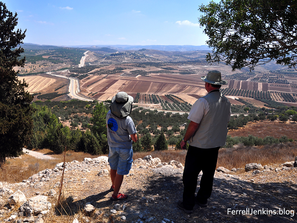
In addition to the tours I led between 1967 and 2016 I have made numerous personal study trips with a variety of friends beginning as early as 1984. The largest number of those trips have been made with Leon Mauldin. On these trips we visit places that are difficult to reach by bus or take an unusual amount of time to reach — too time consuming for a group looking to see all they can in a typical 10-12 day tour.

In September, 2011, Leon and I spent some time in the south of Israel. One of the fascinating places we visited was the Brook Besor. Israelis call it Nahal Besor. Various English versions of the Bible use the terms Brook, brook or Wadi to describe the stream. For anyone who might wish to visit the area I will explain how we got there.

Using the modern maps at your disposal locate Beersheba (Be’er Sheva), then take highway 25 NW to highway 241 and turn left. Our first photo was made on the north side of highway 241 after we crossed the Besor.

Brook Besor on the north side of highway 241. Photo: ferrelljenkins.blog.

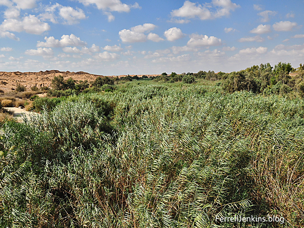
The Brook Besor on the north side of highway 241. Notice the typical dry terrain of the Negev in the background. Photo by Ferrell Jenkins.

Water is flowing somewhere among these reeds and during the winter rains we may be sure that the water is visible. Notice the dry terrain in the distance.

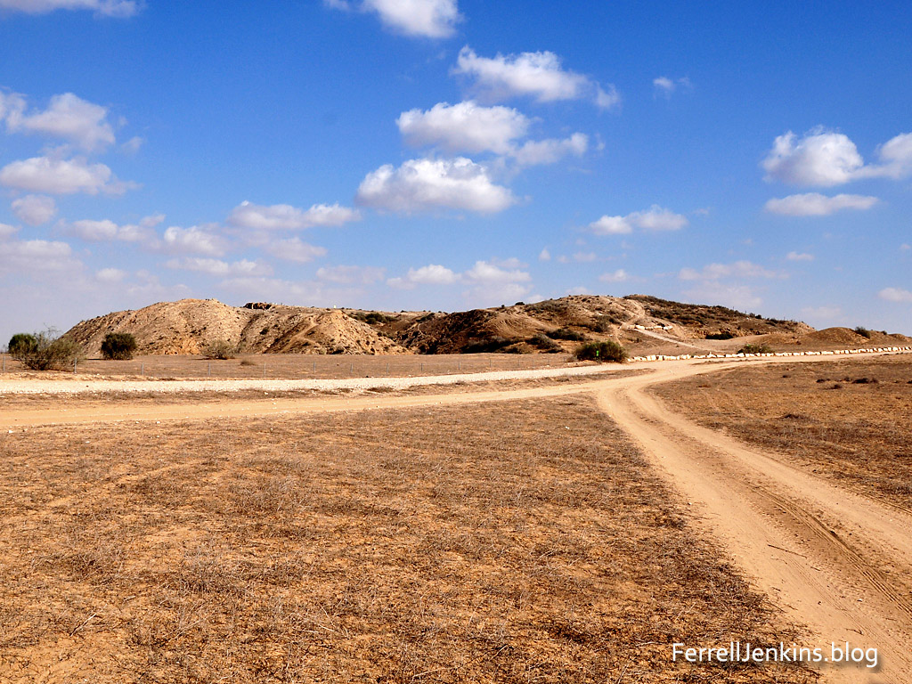
A short distance from the location of this photo, on the south side of the highway we saw this impressive mound. It is easy to reach, at least in dry weather, using the road across the fields.

Tel Sharuhen on the banks of Nahal Besor. ferrelljenkins.blog.

Tel Sharuhen on the banks of Nahal Besor. Most of the reeds like those we have shown in the photo above are on the opposite side of the tel. Photo by Ferrell Jenkins.

The Arab name for this archaeological mound is Tell el-Farah (South) to distinguish it from Tell el-Farah (North), the site of biblical Tirza near Shechem (1 Kings 15:33).

The Archaeological Encyclopedia of the Holy Land (1990) entry begins with this description of the Tell el-Farah (South).

The site is some 14 miles south of Gaza and 16 miles west of Beer-Sheba, near the ancient Via Maris (Roads) connecting Egypt and Mesopotamia. W.M.F. Petrie identified Tell el-Farah with Beth-Pelet (Josh. 15:27; Authorized Version: ‘Beth-Palet’), but W.F. Albright’s identification with Sharuhen (Josh. 19:6) is now accepted by most scholars. Apart from the biblical reference, Sharuhen appears three times in Egyptian sources of the New Empire: in the description of the Hyksos expulsion from Egypt, when Amosi besieged the Hyksos for three years at Sharuhen; in the records of the first campaign of Tuthmosis III; and in those of the campaign of Pharaoh Sheshonq.

Sharuhen is mentioned only once in the Bible as a city of the tribe of Simeon (Joshua 19:1-8; see especially verse 6).

This area looks rather hidden from society, but it was on two major international highways in biblical times.

Leon and I were looking for the possible site where David left 200 men who were too exhausted to make the trek to chase those who had burned Ziklag and taken several captives including two wives of David (1 Samuel 30; see especially verses 9, 10, and 21). I can easily envision this area being the place of the crossing of the Besor.

Ferrell Jenkins at Tel Sharuhen. ferrelljenkins.blog.

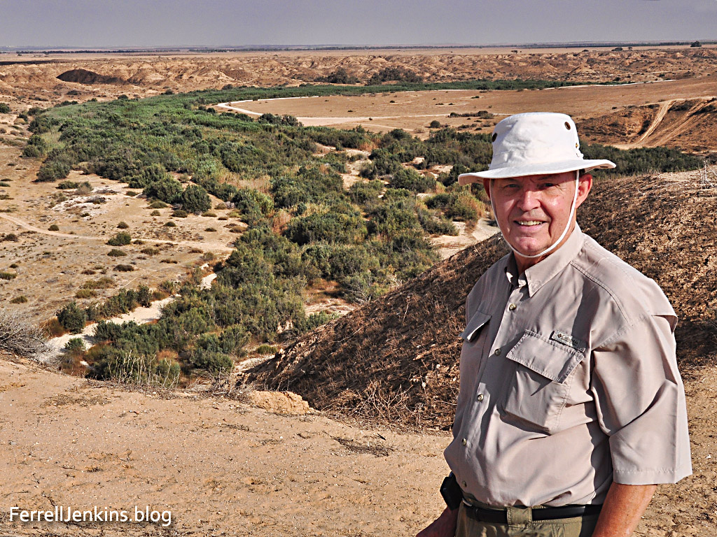
Brook Besor on the north side of Tel Sharuhen. This picture including Ferrell Jenkins was apparently made by Leon Mauldin. You have a nice view of the Brook Besor. Photo: ferrelljenkins.blog.

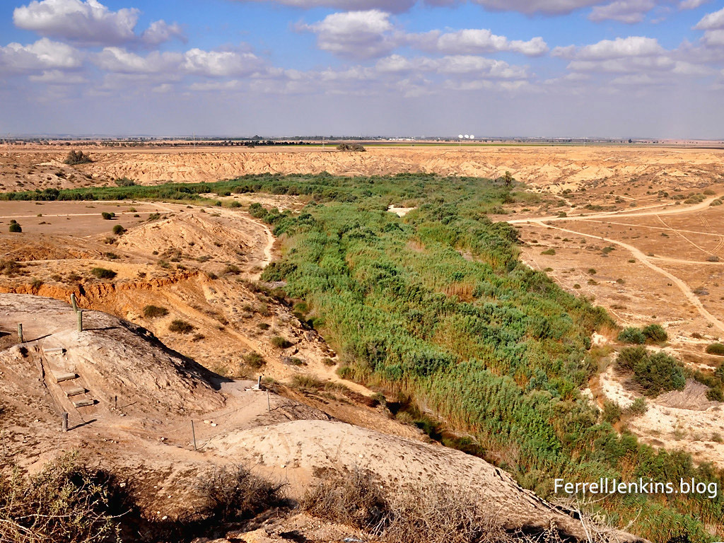
From the south side of the tel we took the steps (lower left corner of the photo) to the top.

Approach to Tel Shuarhen from the south. View of Brook Besor. Photo ferrelljenkins.blog.

Approach to Tel Sharuhen from the south. View of Brook Besor. Photo by Ferrell Jenkins.

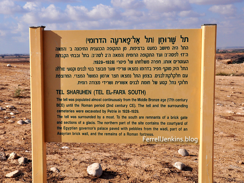
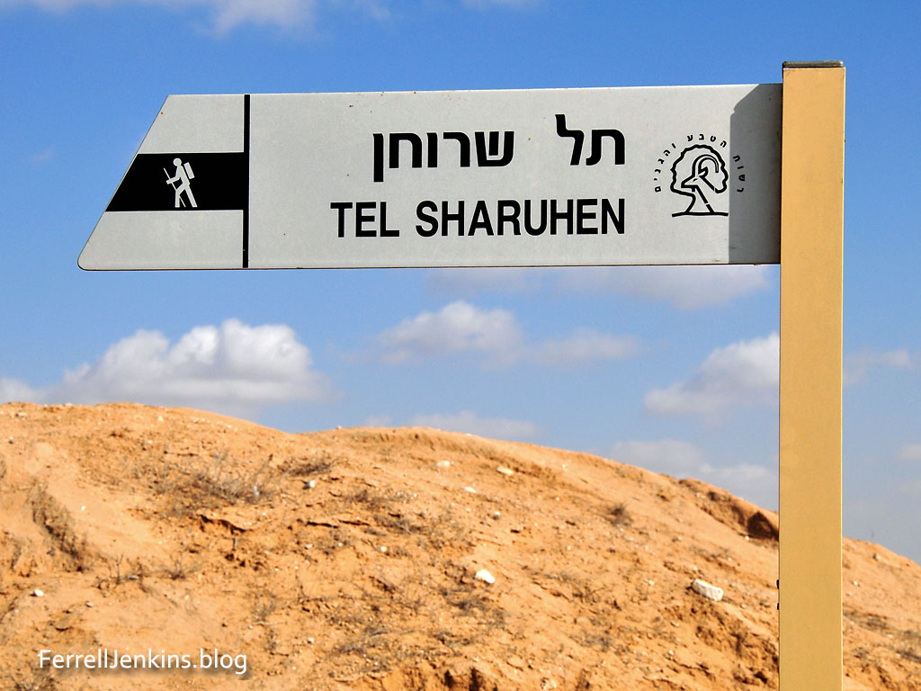
The following signs in Hebrew and English identify the site as Tel Sharuhen.

Sign identifying Tel Sharuhen. Photo: ferrelljenkins.blog.

A nice sign identifying the tel as Tel Sharuhen. Photo by Ferrell Jenkins.

I was delighted when I saw these signs were  new.

Sign identifying Tel Sharuhen. Photo: ferrelljenkins.blog.

Sign in Hebrew and English identifying the mound as Tel Sharuhen. Photo by Ferrell Jenkins.

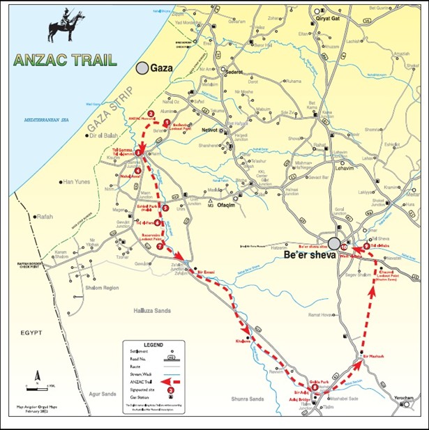
There are also signs at the site identifying Tel Sharuhen as part of the ANZAC Trail. This trail was made famous in 1917 when a light horse brigade of mostly Australian and New Zealand aboriginals defeated the Germans in the region.

The Anzac Trail of 1917. Tel Sharuhen is marked as number 6.

For those with further interest in the historic battle of 1917 I suggest two links. This link in the Times of Israel tells about the centennial retracing the route of the battle by descendants of the Aboriginal ANZAC soldiers in 2017.

More general information about the ANZAC Trail, including directions and a PDF of the map above, may be read here.

The seven photos in this post are sized suitable for use in a PowerPoint presentation for teaching.