Category Archives: Bible Study

The Sea of Galilee and Mount Arbel from the NW

This photograph of the Sea of Galilee and Mount Arbel was made from highway 807.

Sea of Galilee and Mount Arbel from the NW. Photo by Ferrell Jenkins.

The Sea of Galilee and Mount Arbel from the NW. Photo by Ferrell Jenkins.

From this point we can see the east side of the Sea of Galilee. Today we know it as the Golan Heights. In Old Testament times it was known as Bashan (Joshua 21:27). Golan was one of the cities of Refuge located in the area. In New Testament times this was the area of the Decapolis (Mark 7:31), and probably the country of the Gadarenes (Matthew 8:28).

Below Mount Arbel runs the Via Maris, the main road leading from the Turan Valley to Capernaum. This road allowed travel and commerce between Capernaum, Magdala, and Tiberias with the cities of Nazareth, Cana, Sepphoris, and Jotapata.

Painting the eyes

Cosmetics and the painting of one’s eyes is nothing new. The photo below shows a Palm-column flask and kohl stick displayed in Boston’s Museum of Fine Arts. The item is said to date between 1386 and 1212 B.C. Information with the item says,

The palm-column flask is one of the best represented types of glass vessels from the New Kingdom. It served as a container for the cosmetic kohl, or eyepaint, made of ground galena mixed with fat or resin and applied to the lids with the slender glass rod.

Palm-column flask and kohl stick. Museum of Fine Arts, Boston. Photo by Ferrell Jenkins.

Palm-column flask and kohl stick. Museum of Fine Arts, Boston. Photo” Ferrell Jenkins.

It was centuries later when Jehu came to see Jezebel at Jezreel. Jezebel, the widow of King Ahab, wanted to make a good appearances on Jehu.

When Jehu came to Jezreel, Jezebel heard of it. And she painted her eyes and adorned her head and looked out of the window. (2 Kings 9:30 ESV)

Perhaps Jezebel did not know that she was preparing herself for her death.

Royal Ontario Museum exhibit showing an Egyptian woman painting her eyes. Photo by Ferrell Jenkins.

Royal Ontario Museum exhibit showing an Egyptian woman painting her eyes. Photo by Ferrell Jenkins.

The prophets also spoke of this practice, but not in a complimentary way, in Jeremiah 4:30 and Ezekiel 23:40.

National Geographic’s Top 10 Museums and Galleries

National Geographic recently released a list of Top 10 Museums and Galleries here.

  1. Smithsonian Institution, Washington, D.C.
  2. Le Louvre, Paris, France
  3. The Acropolis Museum, Athens, Greece
  4. State Hermitage, St. Petersburg, Russia
  5. The British Museum, London, England
  6. The Prado, Madrid, Spain
  7. The Metropolitan Museum of Art, New York City
  8. The Vatican Museum, Vatican City, Italy
  9. The Uffizi Gallery, Florence, Italy
  10. Rijksmuseum, Amsterdam, the Netherlands
Entrance to the Louvre at night. Photo by Ferrell Jenkins.

Entrance to the Louvre at night. Photo by Ferrell Jenkins.

Over the years I have had the opportunity to visit each of these museums at least once. While I enjoy the art, I am usually looking for artifacts that provide some background for the Bible. That would make a good list.

If I should be asked to suggest number 11, it would be the Pergamon Museum, Berlin, Germany.

The reforms of Hezekiah

After the death of Solomon, the nation of Israel divided into Israel (the northern kingdom) and Judah (the southern kingdom). With the introduction of calf worship by Jeroboam, the kingdom of Israel never recovered. Eventually the kingdom fell to the Assyrians between 732 and 721 B.C.

In the southern kingdom of Judah (the House of David) it was different. From the time of king David onward (1110–970 B.C.) all of the kings of Judah were his descendants. Some of them were faithful to the LORD and others were not. There were departures from the way of the LORD into idolatry.

A visit to the Israel Museum, or to a variety of sites, will provide numerous illustrations of this idolatry. One example comes from Beersheba (Beer Sheva). The archaeological excavation at the site is well marked for the benefit of the visitor. Before entering the tel one passes through a square in which stands “a reconstructed replica of a large, sacrificial four-horned altar whose stones were discovered incorporated into a storehouse wall.” (This statement comes from a beautiful brochure provided for visitors by the Israel Nature and Parks Authority.

Reconstructed four-horned altar from Beersheva. Photo by Ferrell Jenkins.

Reconstructed four-horned altar from Beersheva. Photo by Ferrell Jenkins.

The brochure continues,

The altar shows that the city had a cultic structure, built in the framework of the religious administration of the Judean monarchy. Its dismantling and burial attest to a change in the kingdom’s ritual customs. Based on the dating of Stratum 2 at the end of the eighth century BCE, the abolishment of the cultic site was connected to the religious reform initiated by King Hezekiah of Judah according to the Bible. (The temple discovered at Tel Arad was also done away with in this reform.)

The original four-horned altar is now displayed in the Israel Museum.

The four-horned altar from Beersheba. Israel Museum. Photo by Ferrell Jenkins.

The four-horned altar from Beersheba. Israel Museum. Photo by Ferrell Jenkins.

The reforms of King Hezekiah of Judah (716/15–687/86 B.C.; Thiele) are described in 2 Kings 18.

He removed the high places and broke the pillars and cut down the Asherah. And he broke in pieces the bronze serpent that Moses had made, for until those days the people of Israel had made offerings to it (it was called Nehushtan). He trusted in the LORD, the God of Israel, so that there was none like him among all the kings of Judah after him, nor among those who were before him.  (2 Kings 18:4-5 ESV)

The Hermon (Banias) River and Falls

Names changes are fairly common in modern Israel. Scholars in the recent past have referred to the river that flows from Banias as the Nahr (River) Banias (Nelson Glueck, The River Jordan, 1945, p. 17).

The Nahr (River) Banias is the easternmost source of the River Jordan. The source of the Banias is located at a site we know as Caesarea Philippi in the New Testament. It is well known to those who study the ministry of Jesus (Matthew 16:13-19). The earlier Greeks carved the name of Pan on the rock and called the place Paneas. Glueck says,

The latter is the name that has endured to this day. The Arabs call it Banias, because every p becomes a b in their pronunciation.

Here is one of the photos I made during a clearing on a rainy day in mid-April.

The site of Caesarea Philippi. Photo by Ferrell Jenkins.

The site of Caesarea Philippi. Photo by Ferrell Jenkins.

The Israel Nature and Parks Authority now call this area the Hermon Stream Nature Reserve (Banias). At the point where the springs now emerges from the ground, this sign can be seen.

Sign at Banias denoting it as the Hermon River Springs. Photo by Ferrell Jenkins.

Sign at the source of the springs denoting them as the Hermon River Springs.

We shortly lose sight of the stream. About 2¼ miles southwest of the source, the stream emerges as the beautiful Banias (or Hermon) Waterfall.

The Banias (Hermon) Waterfall. Photo by Ferrell Jenkins.

The Banias (Hermon) Waterfall. Photo by Ferrell Jenkins.

As the river continues south, it soon merges with the other streams and becomes the famous Jordan River. I am rather certain in my mind that a decade or so ago this waterfall was identified as the Jordan River Fall. Technically, of course, it would still be the Banias or Hermon.

One can see why Israel would name the river the Hermon rather than call it by the Arab name Banias. But, it sometimes gets confusing — just like Bible translations of similar names.

Egyptian sphinx fragment found at Hazor

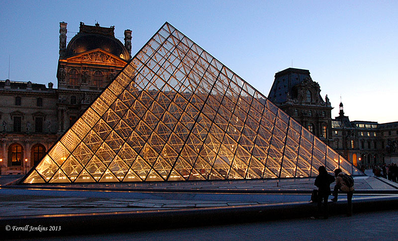
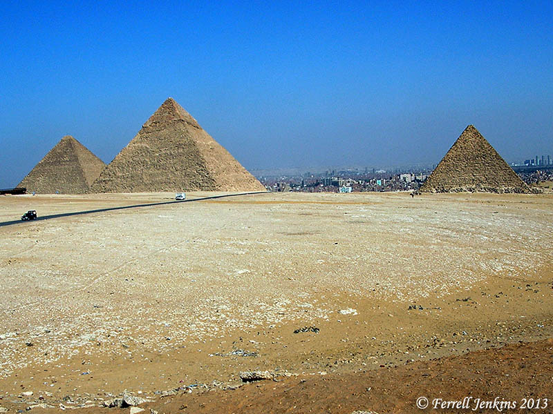
The Hebrew University of Jerusalem announced today the discovery at Hazor of a sphinx fragment of Pharaoh Mycerinus. Mycerinus is the builder of the smallest of the three great pyramids of Giza in Egypt. The photo below was made facing east toward the Nile Valley. The pyramid of Mycerinus is on the right. The pyramid, built about 2500 B.C., is 204 feet high.

The pyramids of Giza" Cheolps, Chephren, and Mycerinus (left to right). Photo by Ferrell Jenkins.

Pyramids of Giza: Cheops, Chephren, & Mycerinus (left to right). Photo: Ferrell Jenkins.

The press release from Jerusalem says,

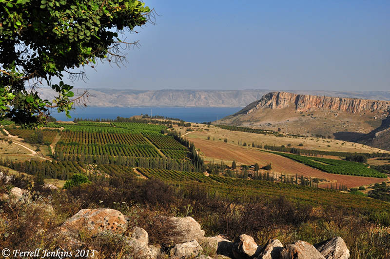
At a site in Tel Hazor National Park, north of the Sea of Galilee, archeologists from the Hebrew University of Jerusalem have unearthed part of a unique Sphinx belonging to one of the ancient pyramid-building pharaohs.

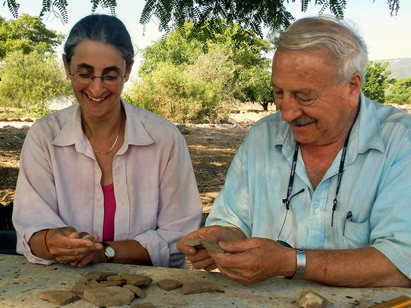
The Hazor Excavations are headed by Prof. Amnon Ben-Tor, the Yigael Yadin Professor in the Archaeology of Eretz Israel at the Hebrew University’s Institute of Archaeology, and Dr. Sharon Zuckerman, a lecturer at the Hebrew University’s Institute of Archaeology.

Prof. Amnon Ben-Tor and Dr. Sharon Zuckerman of the Hebrew University’s Institute of Archaeology, who are leading the Hazor Excavations (Photo courtesy archaeologists Prof. Amnon Ben-Tor and Dr. Sharon Zuckerman)

Prof. Amnon Ben-Tor and Dr. Sharon Zuckerman of the Hebrew University’s Institute of Archaeology, who are leading the Hazor Excavations (Photo courtesy archaeologists Prof. Amnon Ben-Tor and Dr. Sharon Zuckerman)

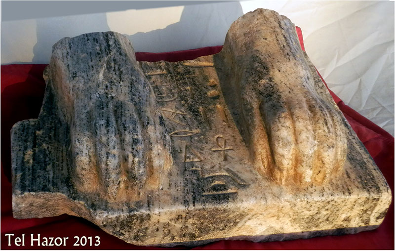
Working with a team from the Institute of Archaeology, they discovered part of a Sphinx brought over from Egypt, with a hieroglyphic inscription between its front legs. The inscription bears the name of the Egyptian king Mycerinus, who ruled in the third millennium BCE, more than 4,000 years ago. The king was one of the builders of the famous Giza pyramids.

As the only known Sphinx of this king discovered anywhere in the world — including in Egypt — the find at Hazor is an unexpected and important discovery. Moreover, it is only piece of a royal Sphinx sculpture discovered in the entire Levant area (the eastern part of the Mediterranean).

Along with the king’s name, the hieroglyphic inscription includes the descriptor “Beloved by the divine manifestation… that gave him eternal life.” According to Prof. Ben-Tor and Dr. Zuckerman, this text indicates that the Sphinx probably originated in the ancient city of Heliopolis (the city of ‘On’ in the Bible), north of modern Cairo.

The Sphinx was discovered in the destruction layer of Hazor that was destroyed during the 13th century BCE, at the entrance to the city palace. According to the archaeologists, it is highly unlikely that the Sphinx was brought to Hazor during the time of Mycerinus, since there is no record of any relationship between Egypt and Israel in the third millennium BCE.

More likely, the statue was brought to Israel in the second millennium BCE during the dynasty of the kings known as the Hyksos, who originated in Canaan. It could also have arrived during the 15th to 13th centuries BCE, when Canaan was under Egyptian rule, as a gift from an Egyptian king to the king of Hazor, which was the most important city in the southern Levant at the time.

Hazor is the largest biblical-era site in Israel, covering some 200 acres, and has been recognized as a World Heritage Site by UNESCO. The population of Hazor in the second millennium BCE is estimated to have been about 20,000, making it the largest and most important city in the entire region. Its size and strategic location on the route connecting Egypt and Babylon made it “the head of all those kingdoms” according to the biblical book of Joshua (Joshua 11:10). Hazor’s conquest by the Israelites opened the way to the conquest and settlement of the Israelites in Canaan. The city was rebuilt and fortified by King Solomon and prospered in the days of Ahab and Jeroboam II, until its final destruction by the Assyrians in 732 BCE.

Documents discovered at Hazor and at sites in Egypt and Iraq attest that Hazor maintained cultural and trade relations with both Egypt and Babylon. Artistic artifacts, including those imported to Hazor from near and far, have been unearthed at the site. Hazor is currently one of Israel’s national parks.

The Hebrew University began the Hazor excavation in the mid-1950s and continued them in the late 1960s. Excavations at the site were resumed in 1990 by Prof. Amnon Ben-Tor, who was joined in 2006 by Dr. Sharon Zuckerman, as part of the Selz Foundation Hazor Excavations in Memory of Yigael Yadin. The present excavation area is managed by Shlomit Becher, a doctoral student of the Hebrew University’s Institute of Archaeology, and is sponsored by the Israel Exploration Society (IES) in cooperation with the Israel Antiquities Authority and the Israel Nature and Parks Authority.

Two views of a Sphinx statue fragment found by Hebrew University of Jerusalem archaeologists at the Tel Hazor excavations north of the Sea of Galilee in Israel. An inscription ties the Sphinx to Mycerinus, an Egyptian king and pyramid  builder, circa 2500 BCE. This is the only known statue bearing this pharaoh's name. (Photo courtesy archaeologists Prof. Amnon Ben-Tor and Dr. Sharon Zuckerman)

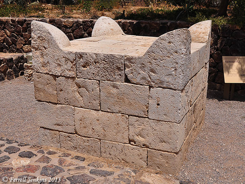
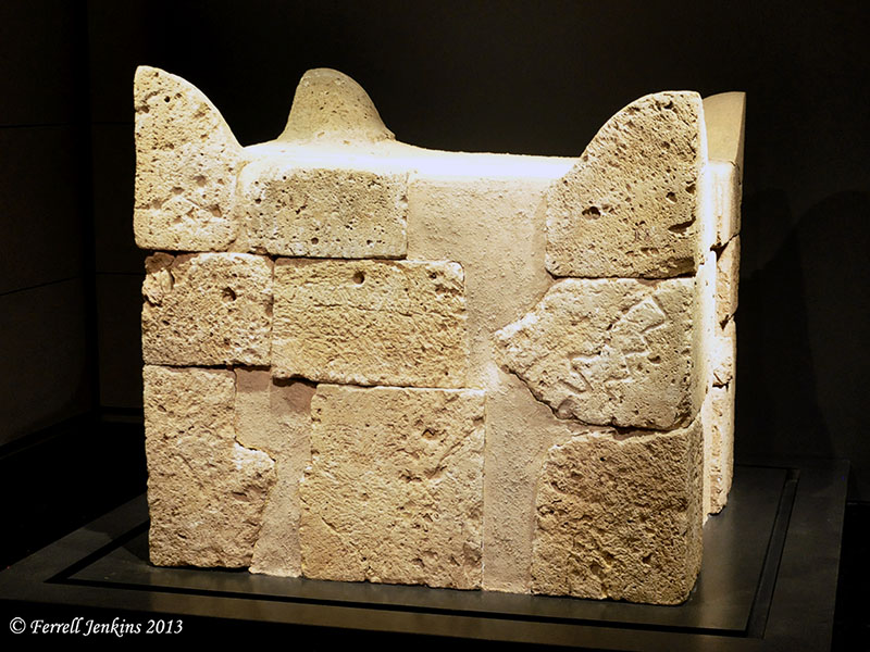
Two views (above and below) of a Sphinx statue fragment found by Hebrew University of Jerusalem archaeologists at the Tel Hazor excavations north of the Sea of Galilee in Israel. An inscription ties the Sphinx to Mycerinus, an Egyptian king and pyramid builder, circa 2500 BCE. This is the only known statue bearing this pharaoh’s name. (Photo courtesy archaeologists Prof. Amnon Ben-Tor and Dr. Sharon Zuckerman)

hu130709_hazor_sphinx2t

Thanks to Prof. Ben-Tor and Dr. Zuckerman for making available these nice photos. We understand better what we are able to see.

HT: Joseph I. Lauer

The topography of Kir-hareseth

Kir-hareseth figures prominently in a story recorded in 2 Kings 3. After the death of Ahab (853 B.C.), Mesha, king of Moab, rebelled against the king of Israel. Jehoram (or Joram; 852–841 B.C.), the king of Israel, did not want to give up the tribute that Mesha had been paying Israel. Jehoram prepared for war and convinced Jehoshaphat (870/69–848 B.C.), king of Judah, to join him to engage Mesha in war. They  decided to take the long, circuitous wilderness route. They would go south of the Dead Sea and approach Moab from the south through Edom.

In the map below you see that Kir-hareseth (site of Karak or Kerak, Jordan) sits only a few miles from the desert and the ancient King’s Highway. The famous Karak Crusader castle provides a view to the west toward the Dead Sea.

Location of Kir-hareseth, modern Kerak in Jordan.

Location of Kir-hareseth, modern Karak in Jordan.

Notice that a valley runs northeasterly from Kir-hareseth to the Dead Sea. Remember that the Dead Sea would be dry south of the Lisan (tongue) except for water that is pumped from the north. In the photos below we can see how this area looks today.

Kerak castle from the west side of the ridge on which it stands. Photo by Ferrell Jenkins.

Karak castle from the west side of the ridge on which it stands. Photo by Ferrell Jenkins.

When we travel down the valley toward the Dead Sea, we can turn back toward the east to see Karak castle on the far right of the ridge. Click on the photo for a larger view.

View from the valley below Kir-hareseth. The view is to the east. Photo by Ferrell Jenkins.

View to the east from the valley below Kir-hareseth. Photo by Ferrell Jenkins.

In the next photo we turn to look down the valley toward the Dead Sea (to the west).

View toward the west from below the Kerak castle. Photo by Ferrell Jenkins.

View toward the west from below the Karak castle. Photo by Ferrell Jenkins.

After the king of Moab offered his oldest son on the wall of the city, the Israelites departed and returned home.

Then he took his oldest son who was to reign in his place and offered him for a burnt offering on the wall. And there came great wrath against Israel. And they withdrew from him and returned to their own land. (2 Kings 3:27 ESV)

The valley we have shown above would be the most natural route to take back to Israel. Kir-hareseth is almost 3000 feet above sea level; the Dead Sea is about 1300 feet below sea level. Highway 50 follows the valley and dead ends at highway 65 which runs north-south along the east side of the Dead Sea.

Understanding the topography of an event helps a lot.

Karak castle plays a role in the 2005 movie Kingdom of Heaven. I found it fascinating because I had been to many of the Crusader sites mentioned in it.

Excavating at Ashkelon – and other places

My friends Trent and Rebekah, participating in the archaeological dig at Ashkelon this summer, have posted a survey of the history of Ashkelon in two parts. In their most recent post which they call “Archaeology 101” they answer some of the common questions they received from acquaintances as they began this project.

Ashkelon is known best to many of us as a Philistine city (1 Samuel 6:17). Trent and Rebekah show us some pottery sherds typical of the period of the Philistines.

Examples of Philistine Pottery Sherds (Left to Right): Philistine Monochrome, Cypriot Milk Jar, another Cypriot Milk Jar, Monochrome Bell Jar Rim and Handle. Photo: Trent and Tebekah

Examples of Philistine Pottery Sherds (Left to Right): Philistine Monochrome, Cypriot Milk Jar, another Cypriot Milk Jar, Monochrome Bell Jar Rim and Handle. Photo: Trent and Tebekah

They explain how their understanding changes as they work at Ashkelon:

Before your eyes, the Philistines transform from the wicked, Samson-hating enemies of Israel to a sophisticated and powerful people–who were also Israel’s enemies.

The tool used by the archaeologist are fascinating to the uninitiated who expect to see a bulldozer and a bull whip. Here are the tools typically found in a square.

Tools of the Trade (Back): Turia, Pickaxe, Brush and Dustpan, (Front) Trowel, Patich, Pottery Bucket. Photo: Trent and Rebekah.

Tools of the Trade (Back): Turia, Pickaxe, Brush and Dustpan, (Front) Trowel, Patiche, Pottery Bucket. Photo: Trent and Rebekah.

Read all about it, and see more photos, at TrentandRebekah.wordpress.com.

Trent and Rebekah were able to meet up yesterday with another friend of mine, Luke Chandler, and (re)visit En Gedi, Dead Sea, and Masada. Luke is working at the Shephelah site of Khirbet Qeiyafa.

I wish the excavation directors at Ashkelon and Khirbet Qeiyafa provided a web site with a few updates on their activities.

Meanwhile, at Tell es-Safi/Gath, Professor Aren Maeir does the best job of anyone I know to keep interested readers informed, and create excitement about archaeology and the dig at Gath. Take a look at his posts during the first week of work at the site. Notice the excitement in the faces of those students who have found a basalt mortar and a bead.

Following the news in the Bible World

Beginning with the Six Day War (June 5-10, 1967) I have tried to keep alert to the situation in the countries that are often called the Bible lands or the Bible World. This phrase is given to the countries of Iran, Iraq, Turkey, Syria, Lebanon, Jordan, Israel, Egypt, Greece, et al. where the events of the Bible transpired. Over the past 47 years I have traveled in all of these countries, some extensively, except Iran.

The current news coming out of Egypt is not good, and it is sad to see the conditions there. I wish for peace and justice for the people of Egypt, and the other countries mentioned above. I wish it also for those who would like to travel to these ancient lands to better learn the history, both secular and biblical.

A scene on the Nile River in Upper Egypt. Photo by Ferrell Jenkins.

A scene on the Nile River in Upper Egypt. Photo by Ferrell Jenkins.

The photo above was made from the Nile River in Upper Egypt, near the ancient town of Edfu. When I look at it I am reminded of the Genesis account of the seven lean cows and seven plump cows that Joseph saw coming up out of the Nile (Genesis 41).

Do we have archaeological evidence the tabernacle was at Shiloh?

During the midst of the allocation of the land to the various tribes of Israel, all of them gathered at Shiloh (Shilo) and set up the tent of meeting or tabernacle (Hebrew mishkan) (Joshua 18:1), which is also called the house of God in Joshua 18:31. Here they made the final division of the land (Joshua 18:8-10).

Then the whole congregation of the people of Israel assembled at Shiloh and set up the tent of meeting there. The land lay subdued before them. (Joshua 18:1 ESV)

Several Israeli newspapers are reporting  a brief notice that archaeologists have discovered holes in the ground at Shiloh which could have held the beams of the Tabernacle. The account in Israel Hayom (Tuesday July 2) is found here.

The findings, which will be presented at a conference of the Shiloh Association scheduled to take place this week in ancient Shiloh, include the discovery of holes carved into the ground which could have held the beams of a temporary structure.

I have visited Tel Shiloh three times in the past five years. The area where the tabernacle is thought to have stood looked this way in May of this year. It was difficult to see what archaeological work was being done. Some of the area looked more like reconstruction.

Area where the tabernacle is thought to have stood at Shiloh. Photo by Ferrell Jenkins, May 2013.

Area where the tabernacle is thought to have stood. Photo by Ferrell Jenkins, May 2013.

Below is a photo of the tabernacle in the wilderness in the park at Timna, a few miles north of Eilat.

The tabernacle in the wilderness at Timna. Photo by Ferrell Jenkins.

The tabernacle in the wilderness at Timna. Photo by Ferrell Jenkins.

We await more information.

There is a web site devoted to Tel Shiloh, but it needs to be updated.

HT: Joseph I. Lauer