
When we speak of the Arabah (or Aravah, in Israel) we are speaking of the part of the Great Rift that begins at the south end of the Dead Sea and continues to Eilat. The distance is about 196 kilometers (121 miles). The Arabah is more or less the divider between Israel on the west and Jordan one the east. At some points the main Israeli highway 90 almost touches the Jordanian border.
Immediately south of the Dead Sea there are many mining installations processing the many minerals available in the Dead Sea. For several miles we continue to see the cliffs along the road, especially on the west side.

Cliffs on the west side of the Arabah a few miles south of the Dead Sea. Photo by Ferrell Jenkins.
I pulled down the August, 1965, issue of National Geographic to look at the article by Helen and Frank Schreider “Journey into the Great Rift” that I recalled reading many years ago. The authors describe the stretch of the Great Rift Valley between the Dead Sea and the Gulf of Aqaba as they were calling it at the time.
South of the Dead Sea, the Great Rift Valley forms a rounded trough that narrows to the Gulf of Aqaba, then broadens again into the Red Sea. Wild, dry country it is, as lifeless today as when trains of camels carried frankincense and myrrh from Yemen to Damascus; as forbidding as when the Nabateans, at the time of Christ. preyed on the caravans and lavished the booty on their capital at Petra. (p. 275)
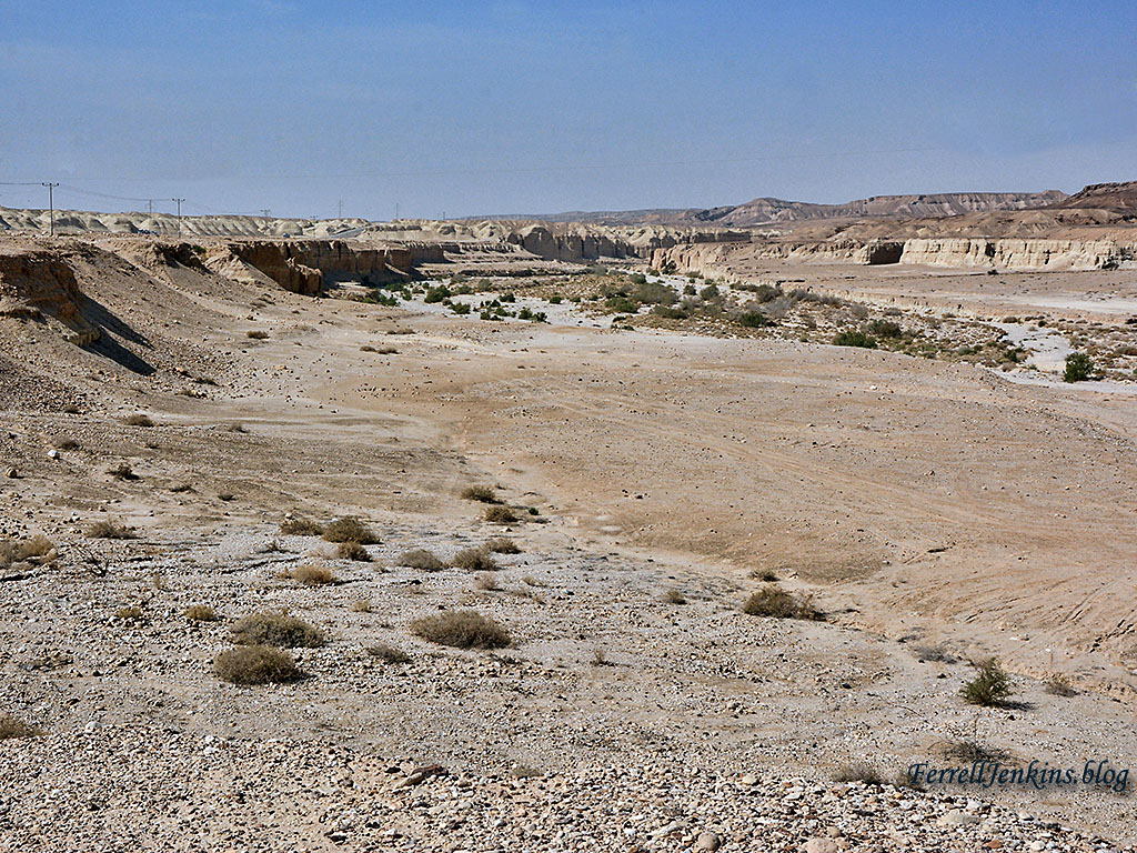
While there is some difference in the terrain along the way, the entire stretch is desert. The photos I wish to share show the typical wadis that run north to south in the valley. This photo shows a wide dry wadi or desert ravine. When it rains in the hills to the west water rushes like a torrent and floods the wadi. Click on the photo for a larger image. You will be able to see various levels where the water has cut along the sides of the wadi.
We always see a line of shrubs in the last place the water runs before soaking into the earth or totally evaporating.

View northwest in the Arabah. This wadi can rage with water after rains in the hills to the west. Photo by Ferrell Jenkins.
Next is a photo looking to the southwest. The hills to the west are lower, but still a lot of water comes down from the central mountain range.
Arabah view to the southwest. Photo by Ferrell Jenkins.
These photos may leave one with the impression that the wadis are harmless, but I can assure you this is not the case. A few years ago I had the unusual opportunity to see the effect of the spring rains in the central mountain rain had on the wadis in the valley. The particular photo shows water rushing down Wadi Kelt (Qelt) at Jericho in a ravine that is normally dry. For more information about this event take a look at my earlier posting here.
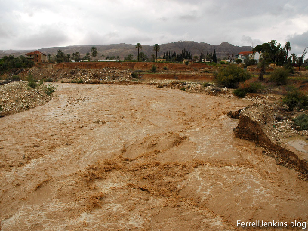
Wadi Kelt at Jericho after heavy rains in the central mountains range April 2, 2006. Photo by Ferrell Jenkins.
Just last week the Israeli papers reported on ten (about 18 year old) teenagers who died when they were swept away by a sudden burst of water while they were hiking in Nahal (Wadi) Tsafit in the desert west of the southern end of the Dead Sea.
Here is a close view of one of the Acacia trees in the Arabah wadi.

Close view of an Acacia tree in the Arabah. Photo by Ferrell Jenkins.
I am including a photo of the leaves of the tree for your consideration. My knowledge of the various flora of the Middle East is limited, but the best I have been able to determine this is an Acacia tortillis. I would be pleased to have comments from someone more knowledgeable on this subject.
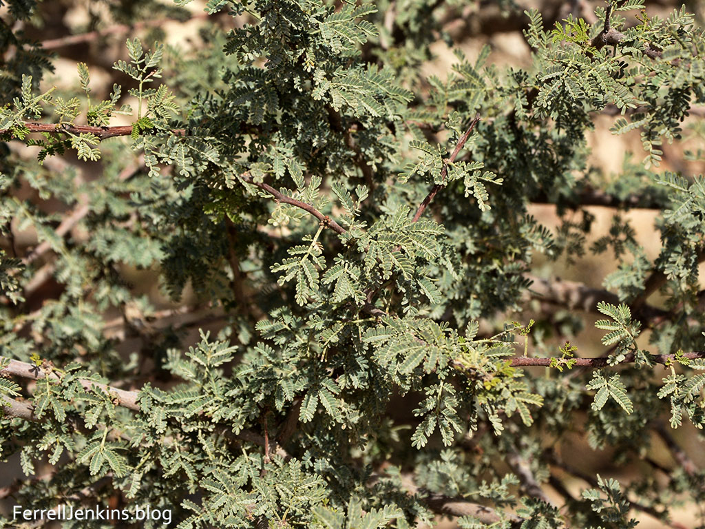
Leaves of the Acacia tortillis in the Arabah. Photo by Ferrell Jenkins.
When the wadi dries up the only comfort left is the shade of a small tree such as this. We have an example of this in the account of Hagar and Ishmael.
When the water in the skin was gone, she put the child under one of the bushes. (Genesis 21:15 ESV)
Our next stop in the Arabah will be at the possible site of Solomon’s “Tamar in the wilderness” (1 Kings 9:17-19).

You must be logged in to post a comment.