
Arriving at Eilat, Leon and I had traveled from the foothills of Mount Hermon to the eastern arm of the Red Sea, the Gulf of Eilat (or Aqabah, depending on whether we are in Israel or Jordan).
Eilat is a popular resort town today, and it has grown tremendously since my first visit in 1973.
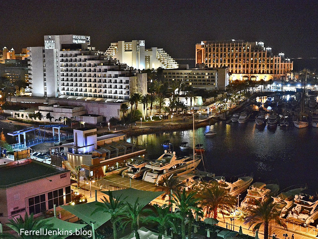
The resort hotels of Eilat are brightly lit at night. Photo by Ferrell Jenkins.
Is Eilat the Ezion-Geber of the Bible? Ezion-geber is said to be near Eloth (Elat, Elath, in some English versions). This area is significant in biblical history.
- Israel camped at Ezion-geber. They journeyed from Ezion-geber and camped in the wilderness of Zin at Kadesh (Numbers 33:35-36).
- Ezion-geber and Elath (or Eloth) are linked together in some references (Deuteronomy 2:8; 1 Kings 9:26).
- King Solomon built a fleet of ships in Ezion-geber. The Bible says it is near Eloth on the shore of the Red Sea, in the land of Edom. (1 Kings 9:26)
In 1938, Nelson Glueck, reported that he had found a copper-refining plant at Tell el-Kheleifeh, which he identified as Ezion-geber, on the north shore of the Gulf of Eilat/Aqabah. This site is now within Jordanian territory. Glueck identified the copper-refining plant as King Solomon’s copper mines, and explained that the apertures in the buildings served as flue holes. Through them, he thought, “the strong winds from the north-northwest entered into the furnace rooms of this structure,” which he called a “smelter, to furnish a natural draft to fan the flames.”
It is true that copper smelting was done in the Arabah in the time of Solomon, but Glueck later changed his mind about the building he had formerly identified as the refining plant. In 1962 Beno Rothenberg demonstrated that the installation at Tell el-Kheleifeh could not have been for copper smelting. Glueck was convinced by his findings that the apertures in the building “resulted from the decay and or burning of wooden beams laid across the width of the walls for bonding or anchoring purposes.” This does not affect any statement of the Bible, but it does mean that the old argument about the copper refining plant found in the Arabah is no longer valid. Glueck’s identification of Tell el-Kheleifeh with Ezion-geber is no longer accepted.
Eilat and Aqabah could be one town in better political times, but today they are separated by an almost invisible line drawn in the sand. I have never been as far south in Jordan as Aqabah, but on a clear day we can see it from Eilat, as the late afternoon photo illustrates.
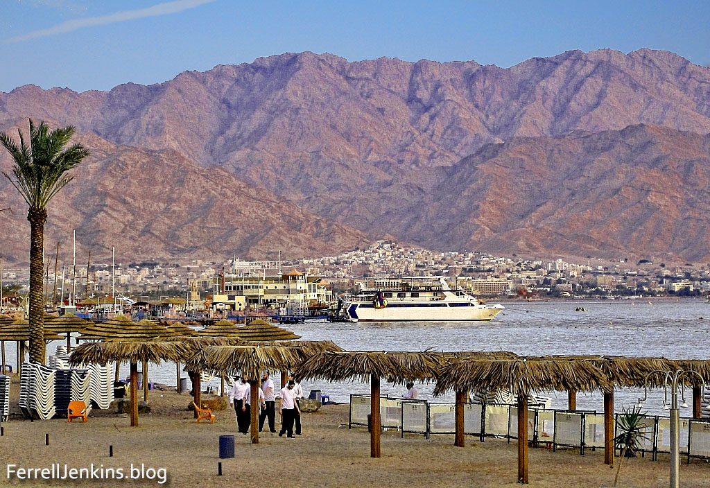
The north end of the Gulf of Eilat/Aqabah. The view is to the east and the city of Aqabah, Jordan. Tell el-Kheleifeh is only a short distance north of the shore in Jordan. This photo was made in January, 2011, at a time when Aqabah could be more clearly seen than late March when we recently visited. Photo by Ferrell Jenkins.
Alexander Flinder says the coastline at Tell el-Kheleifeh is a “sandy beach, with shallow water – totally unsuitable for small craft, let alone for a substantial merchant fleet” (“Is This Solomon’s Seaport?” BAR, July/August 1989, p. 38). Flinder has suggested that Ezion-geber may have been on a small island in the Gulf of Eilat/Aqabah called Jezirat Faraun (Pharaoh’s Island). It is located about seven miles south of modern Eilat, but now under Egyptian control. Flinder’s study shows that there has been an artificial harbor at this location in several historical periods and that it was characteristic of other known Phoenician ports. See the complete article for more details and photos.
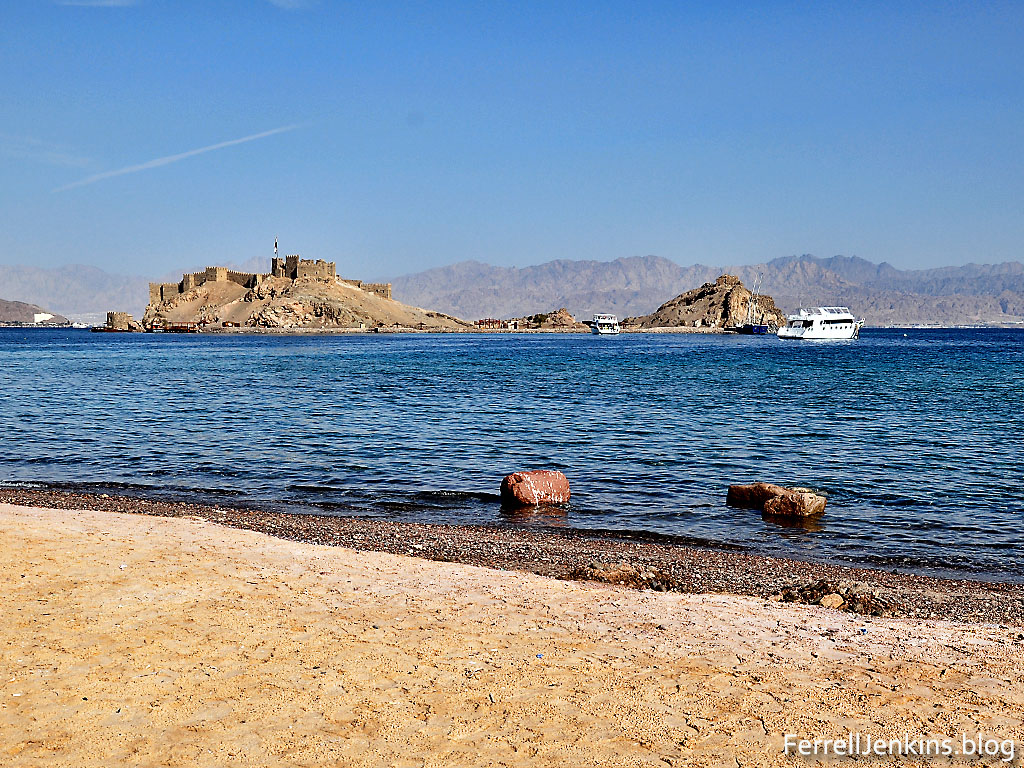
Pharaoh’s Island in the Gulf of Eilat/Aqabah from the west. The island is currently under Egyptian control.Photo by Ferrell Jenkins.
Meir Lubetski, The Anchor Yale Bible Dictionary, says,
Unique were the underwater archaeological findings which established the existence of an artificial enclosed harbor bordering a sizable natural anchorage, with jetties built out into the water to influence currents opposite the island on the shore of the mainland.
I can only point to a suggestion regarding the identity of Ezion-geber with Eloth (Elath). Kenneth A. Kitchen (New Bible Dictionary, 3rd ed., 1996, p. 305). says the two places were,
- Separate stations during the Israelite wandering (Numbers 33:35-36; Deuteronomy 2:8).
- Ezion-geber appears to be mentioned alone in the 10th-9th centuries, and is the point from which Solomon sent ships.
- Jehoshaphat’s planned expedition from Ezion-geber was wrecked (1 King 22:48; 2 Chronicles 20:36-37).
- King Uzziah of Judah captured Elath/Eloth from Edom and rebuilt it in the 8th century (2 Kings 14:22).
- Ahaz lost the port to the Edomites (2 Kings 16:6).
The map at BibleAtlas.org shows the places we have discussed in this post. Notice the location of Ezion-geber is indicating, with a question mark, the location of Pharaoh’s Island.
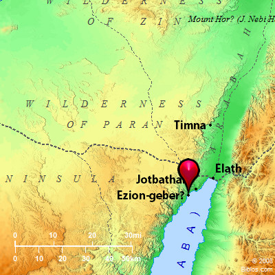
Map of Ezion-geber, Elath, and Timnah, and a portion of the Arabah. BibleAtlas.com.
We plan next to visit Timna and learn about the copper mining in the area.

You must be logged in to post a comment.