Monthly Archives: March 2011

Something Irish

Many Americans have Irish backgrounds. Something Irish may be appropriate today.

This photo of gently rolling hills of northern Ireland is typical of the northern part of Ireland. The closest large town is Armagh, but it is between Rich Hill and Ahorey.

Farm land near Ahorey Church, near Rich Hill, N. Ireland. Photo by Ferrell Jenkins.

Farm land near Ahorey Church, North Ireland. Photo by Ferrell Jenkins.

Students of the Restoration Movement will recognize this area as the home of Thomas and Alexander Campbell in the early 1800s, prior to their departure for America.

Some time I would like to post several photos of Irish sites associated with the Campbells.

The flea river: Nahr Bareighit or Nahal Iyon

The least known of the sources of the Jordan River is the Nahr Bareighit (flea river) or Nahal Iyon (the name used in Israel). Like the Senir (Hasbani), this river begins in the Beka Valley of Lebanon. It is often overlooked when the sources of the Jordan are named.

Nelson Glueck, The River Jordan, describes the Nahr Bareighit.

The westernmost source of the Jordan is the small mountain stream, Nahr Bareighit. Through a rude gorge, it tumbles down southward from the hilly meadowland of Merj ‘Ayun, which retains in clear part its ancient Biblical name of Ijon (1 Kings 15:20), to add its waters to the formation of the fateful [Jordan] river. The Nahr Bareighit joins the Nahr Hasbani about three quarters of a mile above the point where the Hasbani joins the junction of the Leddan and Banias streams. These last two alone were anciently considered as the sole sources of the Jordan. All found help to form it, and lose their identity in it, as the Jordan starts it flow under its own name.

“Roll, Jordan, roll;
I want to go to heaven when I die
To hear sweet Jordan roll.”

Deni Baly, The Geography of the Bible, devotes a single sentence to this little stream.

The basin of Marj ‘Ayoun to the west is drained by the smaller Bareighit, which leaps over the threshold in a series of charming waterfalls near Metullah and postpones its junction with the Jordan until just before the Huleh marshes. (193)

The photo below shows the Iyon Mill Falls. It is one of the beautiful photos of several falls on the river from the Pictorial Library of Bible Lands. Check BiblePlaces.com to purchase the complete set or the DVD of Galilee and the North.

Nahal Iyon Mill Falls. Photo: BiblePlaces.com.

Nahal Iyon Mill Falls. Photo courtesy of BiblePlaces.com.

The Senir, a source of the Jordan River

The longest source of the Jordan is the 24-mile-long Nahr Hasbani which begins in the Beka Valley of Lebanon and flows south to join the Jordan. Israel has replaced many of the Arabic names that were commonly used in earlier decades with Hebrew names. The Old Testament says that the Sidonians “call Hermon Sirion, and the Amorites call it Senir” (Deuteronomy 3:9). The river is now designated Senir in Israel.

At the Senir (Hasbani) on Israel Highway 99. Photo by Ferrell Jenkins.

At the Senir (Hasbani) on Israel Highway 99. Photo by Ferrell Jenkins.

Other passages identifying Mount Hermon as Senir are 1 Chronicles 5:23, Song of Solomon 4:8, and Ezekiel 27:5. Nelson Glueck, The River Jordan, calls attention to Psalm 42:6, translating it this way:

O my God, my soul is cast down within me: Therefore am I mindful of thee from the land of the Jordan, and the Hermons” (Psalm 42:6)

The plural of the Hebrew word chermonim is bought out in the English translations by phrases like “peaks of Hermon” or “heights of Hermon.”

Israel Highway 99 runs north east from Kiryat Shmona to the Golan Heights past Tel Dan and Banias (Caesarea Philippi) and two other sources of the Jordan (the River Dan and the River Banias). Because this river begins in the vicinity near Mount Hermon, it is called the Senir.

The photo below is the view north from Highway 99.

The Senir River (Hasbani) view north from HWY 99.

The Senir River (Hasbani) view north from HWY 99. Photo by Ferrell Jenkins.

I think the slide on the west side of the river is used to launch kayaks into the river.

Shattered dreams

Qumran Replica

Qumran Replica

Back in early February I posted a poll here from Jerusalem asking, “Did Ferrell purchase the Qumran Jar replica?” I may have set a limit on the time frame for voting. There were 101 total votes. Here are the results:

  • Yes — 39.6%
  • Absolutely not — 14.85%
  • No, but he lusted — 45.54%

Drumroll! The answer: Yes, and he had it shipped from the shop to his home in Florida. I guess this says something about polls.

The photo to the right shows the beautiful Qumran Jar replica, like those the Dead Sea Scrolls were stored in for nearly two millennial, as it looked the day I purchased it in Jerusalem. The package arrived at our home about four weeks later. I was delighted to receive it, but when I opened the package this is what I found.

The broken Qumran Jar replica. Photo by Ferrell Jenkins.

The broken Qumran Jar replica. Photo by Ferrell Jenkins.

The manager of the shop at the City of David Visitors Center has been very nice and promises that another jar will be on the way shortly. We had paid about as much for insurance as for the jar.

Perhaps I should take the attitude of a lady guide in Russia about 20 years ago. She was a staunch party loyalist. When some of our ladies asked her about the availability of sugar, she said that it was not available. Then she added, “But we don’t need it.”

Well, I can still get at few biblical lessons from this experience.

Prior to the Babylonian destruction of Jerusalem in 586 B.C. the prophet Jeremiah was instructed to break a jar in the presence of the leaders of the people and of the priests.

The LORD continued, “Now break the jar in front of those who have come here with you. Tell them the LORD who rules over all says, ‘I will do just as Jeremiah has done. I will smash this nation and this city as though it were a potter’s vessel which is broken beyond repair. The dead will be buried here in Topheth until there is no more room to bury them.’ I, the LORD, say: ‘That is how I will deal with this city and its citizens. I will make it like Topheth. (Jeremiah 19:10-12 NET)

If I get sick with boils I can use the potsherds like Job did.

Job took a shard of broken pottery to scrape himself with while he was sitting among the ashes. (Job 2:8 NET)

Here and there in biblical blogdom

Dr. Carl Rasmussen, the name back of those great photos at Holy Land Photos (now more than 3100) and author of the excellent Zondervan Atlas of the Bible (Revised edition), recently started a blog under the title HolyLandPhotos’ Blog. I think you will enjoy following it here. The blog discusses “Sites, Peoples, and Events Related to the Bible, Ancient Near East, and Classical Studies.” Click Zondervan Atlas of the Bible to buy this book at Amazon for $26.39 (post paid). That is a saving of 34%.

Wayne Stiles (blog is here) has an article about the “Historical marvels at Tel Dan” in a recent Jerusalem Post here.

Luke Chandler calls attention to a fascinating BBC 2010 article on the British Museum which says the 80,000 object on display amount to just 1% of the eight million artifacts in the Museum collection. See Luke’s comments and the link at Luke Chandler’s Blog here.

If you plan a trip to London, I suggest you take a copy of my seven page paper on Some Biblically Related Artifacts in the British Museum. Get it in PDF here.

The photo below is of an Egyptian Brick Making Model. That leaves 79,999 more (+/-).

“Don’t continue to supply the people with straw for making bricks, as before. They must go and gather straw for themselves. (Exodus 5:7 CSB)

Egyptian Brick Making Model. British Museum. Photo by Ferrell Jenkins.

Egyptian Brick Making Model. British Museum. Photo by Ferrell Jenkins.

Leon Mauldin is traveling in Israel. Read his reports at Leon’s Message Board here.

Prof. Aren Maeir reports on the availability for download of old reports on the excavations at Megiddo by the Oriental Institute of the University of Chicago.

The Oriental Institute of the University of Chicago announces the online publication of four older titles. Internet publication of these books was made possible through the generous support of Misty and Lewis Gruber.

  • OIC 9. New Light from Armageddon: Second Provisional Report (1927-29) on the Excavations at Megiddo in Palestine. By P. L. O. Guy. Oriental Institute Communications 9. Originally published in 1931.
  • OIP 26. Material Remains of the Megiddo Cult. By Herbert Gordon May. Oriental Institute Publications 26. Originally published in 1935.
  • OIP 32. The Megiddo Water System. By Robert S. Lamon. Oriental Institute Publications 32. Originally published in 1935.
  • SAOC 17. Notes on the Megiddo Pottery of Strata VI-XX. By Geoffrey M. Shipton. Studies in Ancient Oriental Civilization 17. Originally published in 1939.

Dr. Leen Ritmeyer writes about the Jordanian-financed restoration of the Dome of the Rock, including a video, here.

Races called off at Caesarea Maritima hippodrome

Friend Leon Mauldin is traveling in Israel for a few days. He reports “a mixture of wind, rain, and sunshine” today. He shared a nice photo of the hippodrome at Caesarea Maritima flooded. Note the heavy clouds and the water crashing in from the sea.

Caesarea Maritima Hippodrome standing in water. Photo by Leon Mauldin.

Caesarea Maritima Hippodrome standing in water. Photo by Leon Mauldin.

Our thanks to Leon for sharing this photo with out readers. You may follow the progress of his tour at Leon’s Message Board here.

We know that Israel needs the rain after several years of drought conditions. The archaeological park was closed due to storm damage in mid-December, 2010. See here.

Here is a photo of the same area made during a dry period.

Caesarea Maritima Hippodrome. Photo by Ferrell Jenkins.

Caesarea Maritima Hippodrome Dry. Photo by Ferrell Jenkins.

Herod the Great built a hippodrome along the coast at Caesarea Maritima in 10 B.C. to celebrate the opening of the city. Read more here.

Peter preached to Cornelius at Caesarea (Acts 10,11).

Paul was imprisoned in the city for two years before departing for Rome (Acts 24:27; 27:1).

Location of the Red Sea crossing and Mount Sinai

Others, in addition to the late Ron Wyatt, advocate the Red Sea Crossing at the Gulf of Aqaba/Eilat. Those who take this view also place Mount Sinai in Saudi Arabia.

If you have not taken a look at Life and Land by Gordon Franz, I suggest you do so. Gordon is a careful scholar. His material is always well researched and documented. One category that caught my attention at Life and Land is called Cracked Pot Archaeology. Here is how he describes this category.

The Cracked Pot Archaeology category contains articles about popular, contemporary archaeological theories and ideas that, like cracked pots, hold no water! These articles are a review, scholarly analysis and critiques of theories and ideas that have been presented on the Internet or popular books, movies, DVD’s and videos.

Over the past few years Gordon has written a number of articles about the claims of the late Ron Wyatt and Robert Cornuke. Cornuke claims to have found an anchor from Paul’s shipwreck on Malta. He also claims to have photographed an inscription with the name Yahweh (LORD/Jehovah) on it. The inscription was found near Jebel al-Lawz, in Saudi Arabia, which, according to Cornuke, Wyatt, and several others, is the real Mount Sinai.

Read the response by Franz here. The final sentence by Franz sums it up:

The assertion that Mount Sinai is at Jebel al-Lawz in Saudi Arabia still lacks credible and verifiable historical, geographical, archaeological, or biblical evidence.

You will find links to three articles dealing with the claim that Jebel al-Lawz in Saudi Arabia is Mount Sinai. Another, more technical article by Franz, is entitled “Mount Sinai is not Jebel al-Lawz in Saudi Arabia.” It is available at the ABR web site here.

Franz claims that the article,

will conclusively demonstrated that there is no credible historical, geographical, archaeological or Biblical evidence to support the thesis that Mt. Sinai is at Jebel al-Lawz in Saudi Arabia.

Later on, over a period of weeks (months?), as time permits, I hope to deal with specific questions about the biblical places mentioned in the account of the exodus.

The terrain in the Sinai peninsula is varied. The photo below shows one scene. This photo was made January 25, 2011, the day the Revolution began in Egypt.

A scene in the Sinai Peninsula. Photo by Ferrell Jenkins.

A scene in the Sinai Peninsula. Photo by Ferrell Jenkins.

Pharaoh’s chariot wheels and other things that won’t float — Examining the claims of the late Ron Wyatt

The late Ron Wyatt is noted for his fabulous claims to have located just about every secret thing there is, including Noah’s Ark, the location of Sodom and Gomorrah and the other cities of the plain, Mount Sinai, the location of the crossing of the Red Sea, wheels from Pharaoh’s chariots, the ashes of the red heifer, the ark of the covenant, etc., etc., etc.

Standish and Standish, two Seventh Day Adventist researchers, wrote a response to Wyatt, who was also a Seventh Day Adventist. In Holy Relics or Revelation, they give a list of 92 things Wyatt claimed to have found. This book is available at Amazon, and is partially available online at Google Books.

Ron Wyatt (1933-1999) was a nurse-anesthetist with no training in archaeology. We might more correctly call him an explorer. Few famous, recognized archaeologists have more than one or two fabulous finds to their credit, but Wyatt found almost everything that was missing!

Typically I receive several Emails each year asking about some of the claims of Wyatt, though they do not always mention his name. Recently I received a PowerPoint presentation attached to the Email. The presentation is entitled “Moses & the Red Sea Crossing Truth or Fiction?” Of course, I believe Moses led the developing nation of Israel through the sea. No one takes credit for producing the presentation. There is no documentation other than Scripture references. Looking at the “Properties” of the presentation that someone borrowed a template from some other presentation.

The Claim

The presentation includes a map showing Succoth immediately north of the Gulf of Suez. That is the wrong position. Israel then traveled across the Sinai peninsula through a wadi running east toward Eilat/Aqaba, then southerly to Nuweiba on the Gulf of Aqaba (Eilat). This, according to Wyatt, is exactly where the Israelites crossed the Red Sea out of Egypt (he considered the Sinai peninsula as Egypt) into the wilderness on the east of the Gulf of Aqaba. This is necessary to place Mount Sinai in Saudi Arabia. Wyatt did some scuba diving and found Pharaoh’s chariot wheels, chariot bodies, human and horse bones.

The photo below is one I took in the vicinity of Nuweiba January 26, 2011. The view is east from the Sinai Peninsula to Saudi Arabia. This point is about 160 miles on a straight line from where the presentation map shows Israel leaving Succoth. It is about 45 miles south of Eilat/Aqaba. Eilat is in Israel; Aqaba is in Jordan. Even the modern roads in the Sinai are not built on a straight line.

So he made his chariot ready and took his people with him; and he took six hundred select chariots, and all the other chariots of Egypt with officers over all of them. The LORD hardened the heart of Pharaoh, king of Egypt, and he chased after the sons of Israel as the sons of Israel were going out boldly. Then the Egyptians chased after them with all the horses and chariots of Pharaoh, his horsemen and his army, and they overtook them camping by the sea, beside Pi-hahiroth, in front of Baal-zephon. (Exo 14:6-9 NAU)

Think about it. A large, powerful, professional Egyptian army had to chase “about six hundred thousand men on foot, aside from children” (Exodus 12:37-38). The Israelites also had their “flocks and herds” and “a very large number of livestock” with them. Yet, the Egyptians could not catch them for more than 160 miles!

Peninsula east to Saudi Arabia. Photo by Ferrell Jenkins.

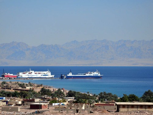
View from Sinai Peninsula east to Saudi Arabia. Photo by Ferrell Jenkins.

I don’t have the time now to do more, but I have located some articles that raise serious questions about Wyatt’s claims. Wyatt was never taken seriously by archaeologists (whether conservative or liberal).

Being Certain About What is Uncertain

Carl Rasmussen comments on the scholarly divide concerning landmarks like the Red Sea and Mount Sinai:

Indeed there are at least ten different proposals for the location of the Red Sea or Reed Sea — including three lakes near the Mediterranean Sea, five lakes along the line of the present-day Suez Canal, as well as the Gulf of Suez and the Gulf of Elath. In addition, there are at least twelve different candidates for Mount Sinai: five in the southern part of the peninsula, four in the north, one in the center, one in Midian (Saudi Arabia), and another in Edom (southern Transjordan). (Zondervan Atlas of the Bible, Rev. Ed., 103).

Responses to Wyatt

Wyatt was a Seventh Day Adventist, but when he was actively making his claims several Seventh Day Adventists scholars took up pen to respond to him. We have already mentioned the book by Standish and Standish.

Dr. David Merling

Dr. David Merling

Dr. David Merling is currently Research Associate in Near Eastern Archaeology at Andrews University, Institute of Archaeology, Berrien Springs, MI. For a number of years he served as Curator of the Horn Archaeological Museum. During the 1990s Merling wrote a number of short articles responding to the claims of Ron Wyatt. These have been archived on the Andrews University web site. Merling discusses the following questions:

  • Who am I and why have I opened this Web site? He explains something about his credentials and states that he has been asked these questions “over and over again.” His comments were last updated in 2006.
  • Has Noah’s ark been found?
  • Ark of the Covenant, has it been found?
  • Did the Israelites cross the Red Sea or the Gulf of Aqaba? This is the specific question that we are now discussing.

You may find Dr. Merling’s material here.

The page dealing with the question of the Red Sea crossing includes maps showing the difference between what the Bible says and what Wyatt claimed. There is also a photo of the column that Wyatt claims is from the time of Solomon. Merling shows that it is from the time of Jesus [Roman], and unlike columns from the time of Solomon.

In another post we will mention more material responding to Wyatt and other pseudo-archaeologists.

Camels in biblical times

Camels are mentioned in the Bible from the days of Abraham (Genesis 12:16) to New Testament times (Mark 1:6). Recently while traveling in the eastern Sinai peninsula near the Gulf of Aqaba (Eilat) we saw a large number of camels with their riders.

Camels in the Eastern Sinai Peninsula. Photo by Ferrell Jenkins.

Camels in the Eastern Sinai Peninsula. Photo by Ferrell Jenkins.

When the Queen of Sheba visited Jerusalem to quiz Solomon she brought with her a large retinue, with camels carrying valuable gifts for Solomon.

Now when the queen of Sheba heard of the fame of Solomon, she came to Jerusalem to test Solomon with difficult questions. She had a very large retinue, with camels carrying spices and a large amount of gold and precious stones; and when she came to Solomon, she spoke with him about all that was on her heart. Solomon answered all her questions; nothing was hidden from Solomon which he did not explain to her. (2 Chronicles 9:1-2 NAU)

Mahanaim — where Jacob wrestled with an angel

The name Mahanaim is found 13 times in the Old Testament. The site is where Jacob and Laban met and made a covenant. Mahanaim seems to mean “two camps” (Genesis 32:2). This is where Jacob’s name was changed to Israel after he wrestled with a man (angel, Hosea 12:4). When morning came Israel crossed over Penuel (Genesis 32:31).

Two large tells face each other and the Jabbok River flows in an S-curve between them. The tells are now named Tall adh-Dhahab East and Tall adh-Dhahab West. These tells are located a few miles east of the Plains of the Jordan and Tell Deir Allah (likely the site of biblical Succoth). Some scholars identify Dhahab West as Mahanaim and Dhahab East as Penuel. Other scholars reverse the identifications.

When Transjordan was divided among the tribes, Mahanaim was located in the territory of Gad on the boundary with East Manasseh (Joshua 13:26, 30). It was one of the cities allotted to the Levites (Joshua 21:38; 1 Chronicles 6:80).

After the death of Saul, Abner made Ishbosheth, the son of Saul, king over all Israel from Mahanaim (2 Samuel 2:8, 12, 29).

When David fled from his rebellious son Absalom he fled across the Jordan to Mahanaim (2 Samuel 17:24, 27; cf. 2 Kings 2:8). Absalom met his death in a nearby forest.

A Gileadite by the name of Barzillai took care of King David while he stayed at Mahanaim (2 Samuel 19:32). The city became one of Solomon’s administrative centers (1 Kings 4:14).

Song 6:13 describes gazing upon the Shulammite girl to be like looking on “the dance of the two camps” or “dance of two companies” (CSB, JPS, NAU, NKJ). Other translations use the expression “the dance of Mahanaim” (ASV, NIV, NJPS, TNIV) or “dance of the Mahanaim” (NET).

Recent excavations at Dhahab West, conducted by a German team, have revealed what they believe to be part of a monumental building of Herod the Great. They think this was the Hellenistic and Roman site described by Josephus as Amathus.

Tall adh-Dhahab East (left) and Tall adh-Dhahab West (right). Photo by Ferrell Jenkins.

Tall adh-Dhahab East (left) and Tall adh-Dhahab West (right). These are thought to be the sites of Mahanaim and Penuel. Photo by Ferrell Jenkins.

Our photo shows both tells. (Tall adh-Dhahab East is on the left. Tall adh-Dhahab West is on the right.) There is a pumping station on the Jabbok to provide agricultural irrigation. The Jabbok continues in the valley separating the two hills and tells.

Click on the photo for an image suitable for use in teaching presentations.