
In this post we wish to follow-up on the work of Dr. James Turner Barclay, medical missionary to Jerusalem in 1851-1854 and 1858-1861, which we have written about here (with other links).
Perhaps Turner’s best known discovery was a gate in the Western Wall of the Temple Mount, now known as Barclay’s Gate. Lewis describes briefly the account given by Barclay in The City of the Great King.
While surveying the Haram precinct [which Christians and Jews call the Temple Mount], Barclay noticed a blocked-up entrance, located 82 meters from the area’s southwest corner. The lintel of this gate is below the Maghrabi gate, which tourists use today to enter the Haram from the west. It is above the women’s area of the western wall, just over the stairway that leads into a room on its south side. Only a part of the lintel is still visible. Some time after the gate was filled in, the corridor into which it led was made into a cistern.
Lewis states that Barclay’s discovery was confirmed by Charles W. Wilson, and later by George Adam Smith. He says,
Barclay considered it to have been one of the four gates mentioned by Josephus in his description of the western wall (Jewish Antiquities, book 15, chapter 11, paragraph 5; see Marcus and Wikgren 1963: 199). Benjamin Mazar has identified Barclay’s Gate as the Kiphonos [Coponius] Gate of the Mishnah (Middoth, chapter 1, mishnah 3; see Danby 1933: 590):
Its tremendous single-stone sill, twenty-five feet long and over seven feet high (7.5 x 2.1 meters), rests on the master course of the Western Wall, that is, at the level of the thresholds of several of its gates. The gateway (opening) is 28.7 feet (8.75 meters) high, but the threshold is missing.… Inside the gate, there was once a vestibule which is now blocked by a wall. Behind the wall a passage leads through one or two ancient cisterns with vaulted roofs which are situated under the Haram platform. Before they were converted into reservoirs, they were stone hallways and formed an underground ramp leading in a southerly direction from the Kiphonos Gate to the upper courts of the Temple area (Mazar [The Mountain of the Lord] 1975: 133–34).
I am hopeful that our photographs will make clear the location of Barclay’s Gate for those who wish to get a glimpse of it on their next trip to Jerusalem. The first photo shows the Mughrabi Bridge entrance.
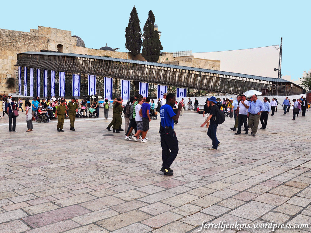
Mughrabi Bridge. Tourists usually enter from Dung Gate and take the bridge up to the only entrance to the platform where the temple once stood allowed for non-Muslims. Photo by Ferrell Jenkins.
Notice where it appears that the bridge reaches the Western Wall. In fact, it makes a right turn to the south, and then a left turn to the east where it reaches the gate. That gate is at the level of the platform where the Temple of Solomon, and Herod’s Temple once stood.
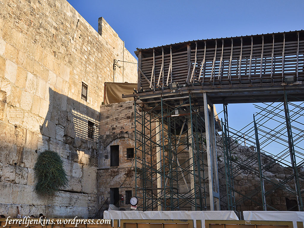
This photo shows the bridge and the structure covering most of the lintel of Barclay’s Gate. Photo by Ferrell Jenkins.
This photo was made from the Mughrabi bridge and shows the left side (north end) of the lintel of Barclay’s gate marked in yellow.
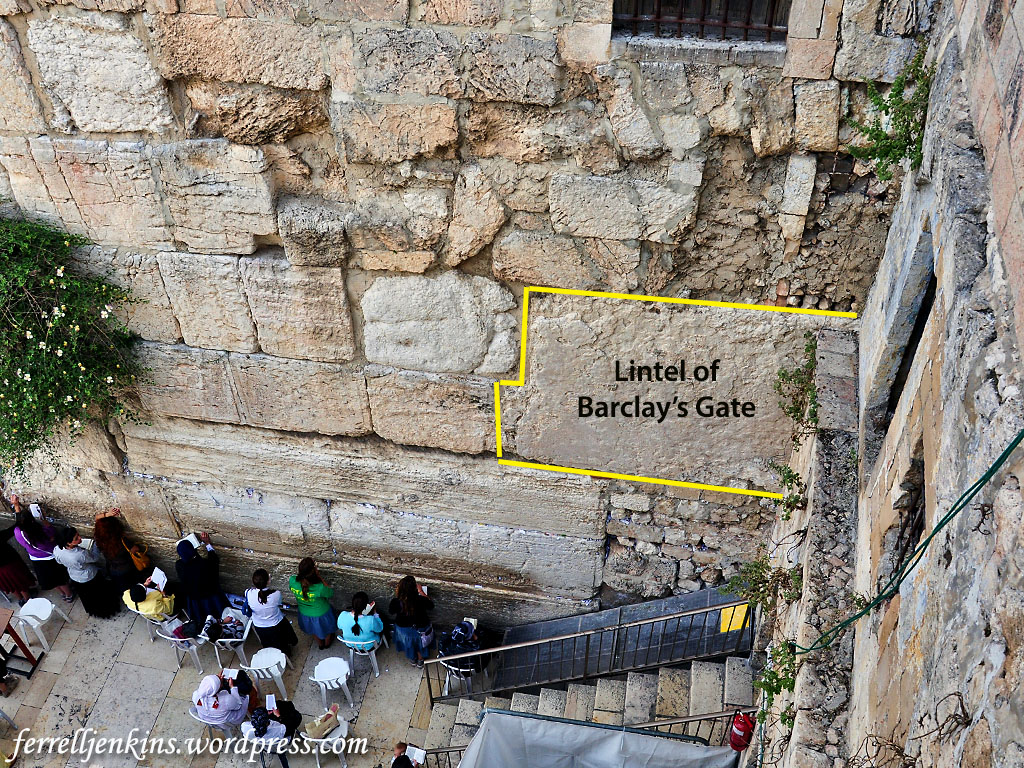
Photo made from Mugrabhi gate bridge with the north end of the lintel identified. Photo by Ferrell Jenkins.
The next photo was made from ground level over the dividing screen that separates the women’s section of the prayer wall from that of the men. The visible portion of the lentel looks smaller here than in the previous photo. Two ladies are standing on the steps at the entrance into the small room where more of the lentel can be seen.
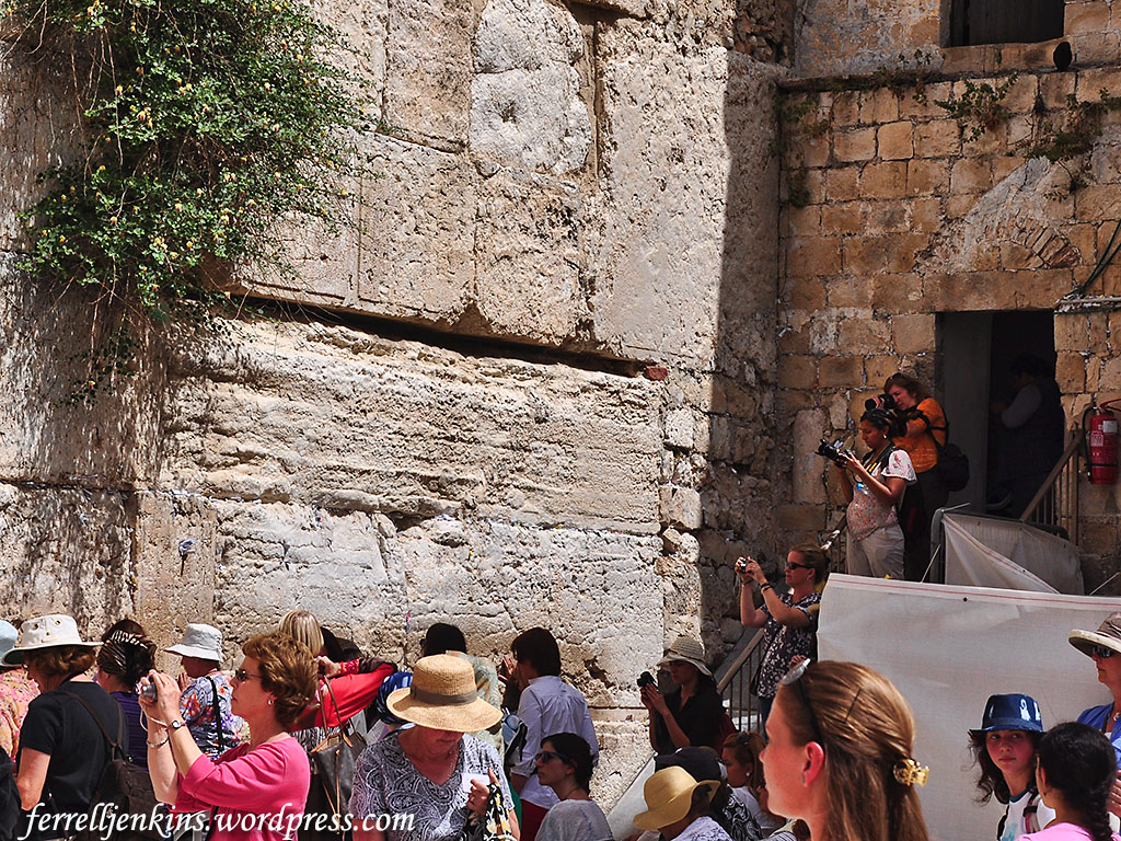
Ground level view with the northern end of the lentel showing. Photo by Ferrell Jenkins.
Leen Ritmeyer has provided numerous drawing of Barclay’s Gate in his books and blog. I recommend that you go there for a better understanding of the gate structure.
- Ritmeyer Archaeological Design. See the post on “Barclay’s Gate in the Western Wall of the Temple Mount” here. This post includes a photo of the central part of the lintel over Barclay’s Gate.
- Ritneyer, Leen & Kathleen. Jerusalem: The Temple Mount. See our notice here.
- Ritmeyer, Leen. The Quest, Revealing the Temple Mount in Jerusalem, pp. 26, 28.
- Ritmeyer, Leen. Understanding the Holy Temple Jesus Knew, pp. 22-23. The drawings and photos in this book are very nice. See our notice here.
Two books that caught my attention are,
- Ben-Dov, Meir. In the Shadow of the Temple, pp. 140-143. Ben-Dov includes a full-page drawing of the gate showing the present level, the Omayyad level, and the Second Temple level. He shows eight layers of Herodian stones below the present level. This work incorrectly identifies Barclay as “an American consul in Jerusalem at the end of the nineteenth century and one of the first scholars of Jerusalem.” Barclay was a medical missionary who lived in Jerusalem on two occasions (1851-1854 and 1858-1861).
- Mazar, Benjamin. The Mountain of the Lord, pp. 133-134. Mazar mistakenly identified Barclay as a “British architect.”
Initially I began with a reference to the following works.
- Lewis, Jack P. “James Turner Barclay: Explorer of Nineteenth-Century Jerusalem.” Biblical Archaeologist 51 (1988).
- Lewis, Jack P. Explorers of Bible Lands. Abilene Christian University Press, 2013. This work includes the essay on Barclay and other biographical portraits by Lewis.
Lewis discusses some of the other discoveries made by Turner.
Barclay’s book is not to be forgotten. The City of the Great King; or, Jerusalem As It Was, As It Is, and As It Is To Be is available in Logos format. It seems to be available only in a 10-volume collection of Archaeological and Theological Studies of Jerusalem. It is also available free at Google Books. I note that a cover of the book shows a drawing of the Temple area, including the “Wailing Place” and nearby an “Old Gateway.”
Added Notes – Sept. 29, 2017
The comment below by Outremer [Tom Powers] was held up by WordPress for my approval, and by some appointments I had. When Tom writes I listen. He always adds something of value. I want you to read the comments in full, but I am including the photos here. I knew that one of them was in Ritmeyer’s blog and for that reason did not include it. And I thought of Todd Bolen’s Historic Views of the Holy Land. One of these photos is in the 8-volume set, “The American Colony and Eric Matson Collection.” Details here.
Here is the first photo Tom mentions.
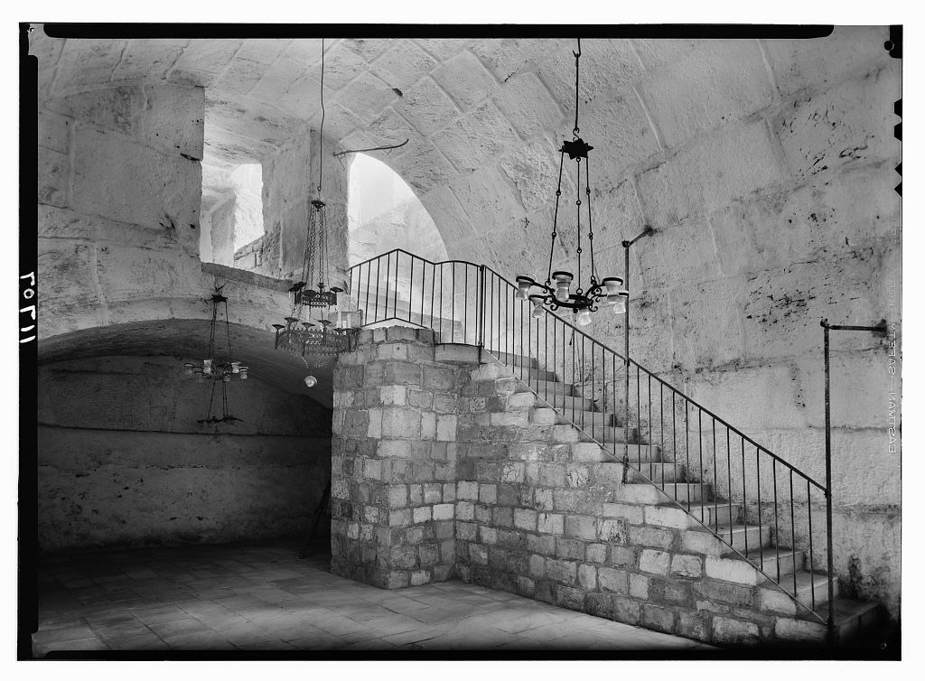
The “al-Buraq” Mosque “built into the vaulted internal gate passage of Barclay’s Gate.” The dark line on the far wall (left of the photo) is “apparently the top of the lintel” (Powers). Eric Matson Photo, 1940s.
The second photo is shown here.
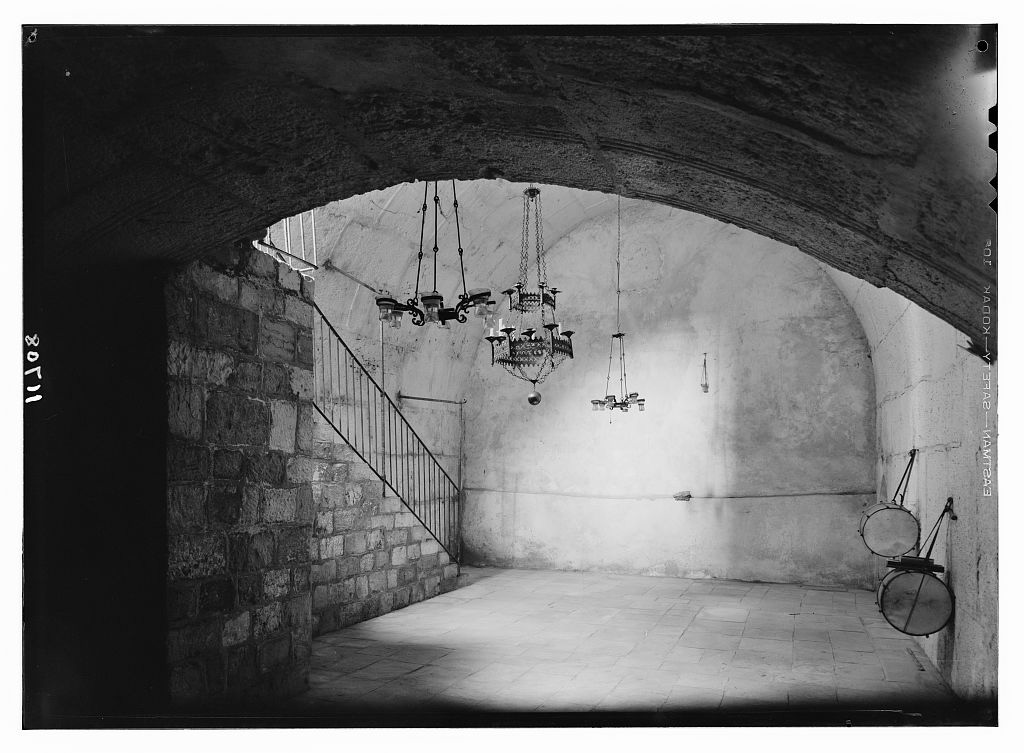
The “al-Buraq” Mosque, “named for the winged beast of Moahmmed’s legendary Night Journey, is built into the vaulted internal gate passage of Barclay’s Gate” (Powers). Photo by Eric Matson in the 1940s.

Modern day interior of the Barclay’s gate, it’s been converted in to a mosque, and most likely out of conveniently available space (just because the space was available) rather than any authentic Islamic tradition attached to it (same case Solomon’s stables).
https://madainproject.com/al_buraq_mosque_(temple_mount)
Scott, I don’t know the answer. Possibly a Google search would lead you to a government site(s) with current info.
> Mr. Jenkins, > I’m sorry I should have clarified myself. I know the traditional site of Sinai is in Egypt and Tim-nah is in Israel (which I know would be safe). My question is regarding travel from Eilat to Sinai and if it is possible or recommended. > I apologize for the confusion. > Scott >
Pingback: Biblical Studies Carnival 9/2017 | Arne Berge
Pingback: Biblical Studies Carnival for September 2017 | Reading Acts
I am just this morning seeing Todd Bolen’s response to a question about material on the Temple. You might like to take a look at his BiblePlaces Blog.
Tom, thanks again for you helpful remarks. I have elevated the photos to be a permanent part of the blog post for the benefit of future readers. Ferrell
Scott, my leaning on the location of Solomon’s Temple and the Herodian Temple (commonly called the Second Temple) is the view presented by Leen Ritmeyer in the books and website I have linked in the article.
Another view, presented by Asher Selig Kaufman, moves the location of the Holy of Holies to the Dome of the Spoirits (or Qubbat al-Arwah). Ritmeyer says this is about 330 feet northwest of the Dome of the Rock (Jerusalem: the Temple Mount, pp.126-127). Murphy-O’Connor says, “it is now certain that the present dimensions of the temple mount are those established by Herod the Great. The location of the Fortress of Antonia is outside the Haram enclosure” (The Holy Land, 5th ed., p. 90).
Trust this will be helpful in your study.
Hello Brother Jenkins, I attended Florida College in the early 80’s and enjoy your posts. Thank you for sharing because it has helped me to appreciate this special place. I have traveled to Israel about a dozen times, and in fact, will be returning in about 3 weeks with a few friends from the Kleinwood Church of Christ. I am not a scholar or expert, other than a love to travel with others and share the experience on a much more casual basis. I recently saw some info. That presents the theory that the Temple Mount is not where the Temple stood, but may have been the Antonio Fortress and the Temple would have been in the area of the ophel as it relates to Josephus’ records. I wanted to get your thoughts/opinion of this and if you thought it had any merit. Any insight and personal thoughts would be appreciated. Thank you, Scott Powell Sent from my iPad
Your readers may be interested in two little-known photographs of the INSIDE of the gate-passage. (Ritmeyer includes one of the images, with little commentary, in his above-mentioned post.) The pictures were taken in the 1940s by Eric Matson, the former American Colony photographer by then working on his own.
Here are the links: http://cdn.loc.gov/service/pnp/matpc/14400/14495v.jpg AND http://cdn.loc.gov/service/pnp/matpc/14400/14496v.jpg. Following are bits of information I compiled in the course of research for Todd Bolen’s “Historic Views” presentation of American Colony/Matson photographs (“Jerusalem” volume), which includes the first of the two images:
The small “al-Buraq” Mosque pictured here — named for the winged beast of Mohammed’s legendary Night Journey — is built into the vaulted internal gate passage of Barclay’s Gate. It is situated immediately to the north of the Mughrabi Gate, but below the level of the Haram platform, from which it is accessed by the two flights of stairs pictured.
Barclay was correct that the mosque space occupied only the uppermost part of the gateway, but, whereas he presumed the existence of a lower room, the mosque actually overlies a great volume of debris deposits (or fill) behind the blocked gate. In the first photo (looking northwest) the vaulting overhead is the top of the Herodian gate passage, and the dark line in the masonry of the far wall (beneath the shallow arch) is apparently the top of the lintel.
The original passage ran eastward from the western wall for at least 70 feet, but it was reconfigured and altered in many ways over the ages. For example, the distinctive arch of chamfered voussoirs (beveled and molded arch-stones) seen here point to a major redesign and rebuilding of the passage in Omayyad times (7th-8th centuries), when the gate was still open and in use. Since the Arab chronicler Al-Muqadassi in 985 still lists the gate (called by him, and all previous Arab sources, Bab Hitta) among the active entrances into the Haram, it must have gone out of use sometime after that, when it would have been blocked. The eastern part of the passage was walled off at some point (see second photo, looking east) for use as a cistern.
It is interesting that the floor level of the mosque lies just a bit higher than that of the prayer plaza outside. In other words, here, within a few meters of each other, on opposite sides of a blocked ancient gate, Jews and Muslims – simultaneously at times, yet always unseen by the other – both pray! What more apt symbol could there be of the shared yet competing attachments inspired by the Temple Mount/ Haram, and the religious and political sensitivities required to hold them in balance.
TOM POWERS / Waynesville, NC