Category Archives: Travel

Like a cluster of henna…

Henna is mentioned only twice in the Bible, both in the Song of Solomon (or Canticles). The Shulammite girl describes her beloved.

My beloved is to me a cluster of henna blossoms in the vineyards of Engedi. (Song of Solomon [Canticles] 1:14 ESV; see also 4:13)

Scholars are divided about the meaning of the Hebrew term used here. Is this woman named Shulamith? Is she from the Jezreel Valley town of Shunem? Is she described as “the Perfect One” (NET Bible)? Or, is there some other plausible explanation?

Tristram mentions finding the “camphire of Engedi” at the site (cf. KJV transliteration of the Hebrew kopher).

The camphire of Engedi, mentioned in the Book of Canticles, we identified in a pretty shrub, with bunches of graceful pink-white blossoms, which was already in flower in some sheltered nooks, and called El-Henna by the Arabs, from which they procure the Henna dye—the Lawsonia alba of botanists. (The Land of Israel: A Journal of Travels in Palestine, Undertaken With Special Reference to Its Physical Character, 294-95).

Some small plants identified as henna can be seen at Neot Kedumim in the low hill country between Modi’in and Tel Aviv. Both they and the Fauna and Flora of the Bible identify it with the Lawsonia inermis. I don’t know how to sort out this name and the Lawsonia alba that Tristram mentions.

Henna growing at Neot Kedumim. Photo by Ferrell Jenkins.

Henna growing at Neot Kedumim. Photo by Ferrell Jenkins.

Henna is used by women of many societies on their hands, and other parts of the body. In several places I have seen local women painting designs on those who wished to try it.

One of the young ladies of my tour got henna tatoos from the Nubians in southern Egypt. Photo by Ferrell Jenkins.

Stacy got henna tattoos from a Nubian lady in southern Egypt near Aswan. She says it lasted about three weeks. Photo by Ferrell Jenkins.

Stacy tells me that the henna caused quite a stir when she returned to work. She says,

I talked with my hands. I gestured during a meeting and it stopped the meeting cold. Everyone stared. I said, “not to worry … it will disappear in 3 weeks” and continued on with the point I was making. 🙂

Life is fun.
Some suggested reading…

Wayne Stiles has a nice blog in which he connects the Bible and its Lands to life. He has suggested five other blogs for his readers here. I am honored to be included in his list. I appreciate these introductory words.

Where biblical events took place are more than throwaway mentions in the pages of Scripture. Often, they have significant bearing on God’s participation in the lives of His people.

Unfortunately, because we’re unfamiliar with geography we often miss these nuggets. I have found a lot of help in several Holy Land blogs that open up the Bible’s lands to my understanding.

Take a look at his list here. How many of them do you read?

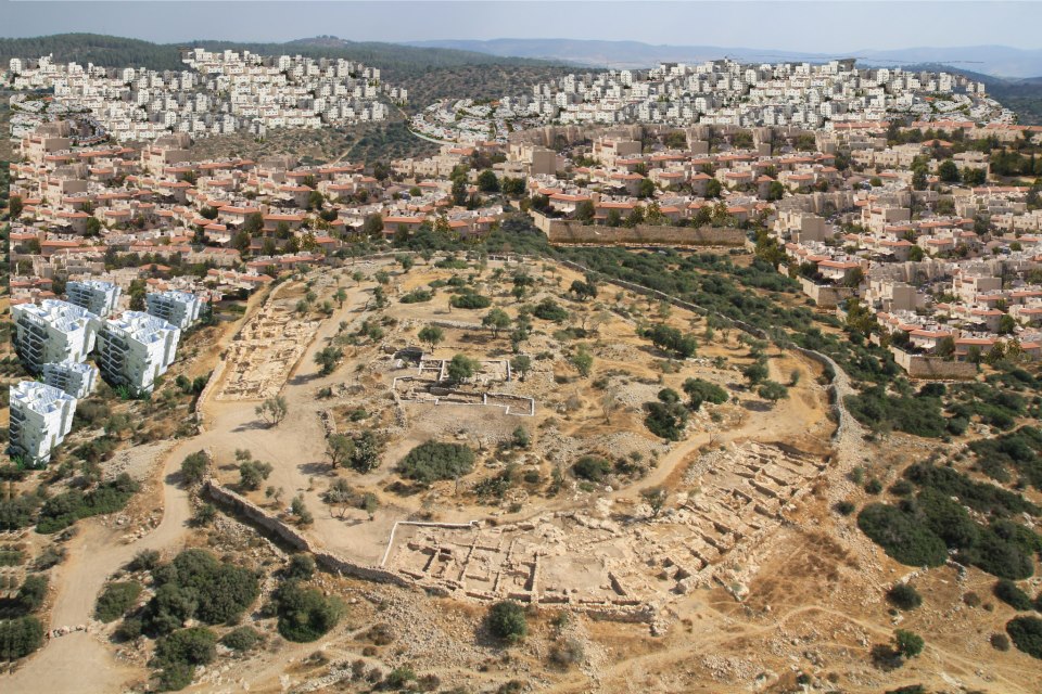
My friend and neighbor Luke Chandler has participated in the archaeological excavations at Khirbet Qeiyafa for at least three years. Qeiyafa is a city overlooking the Valley of Elah. Luke reported recently that a massive building program at the nearby town of Beit Shemesh would bring new residential buildings “no more than 20 meters from Qeiyafa’s western gate and wall.” At the present time the entire area from Qeiyafa eastward is without housing. The houses that have been drawn in show the proposed construction. Progress is sometimes good, but this is sad.

Proposed construction at Khirbet Qeiyafa.

The current plan for the expansion of Beit Shemesh. Some buildings are no more than 20 meters or so from the casemate wall and gate. The likelihood of damage to the site during and after construction would be significant. (Comment by Luke Chandler)

You can read Luke’s comments and see others photo here. Visit the Khirbet Qeiyafa: Save King David’s City Facebook page here. You will find more photos and diagrams.

The Great Pool at Gibeon

There are two references in the Bible to the pool of Gibeon. The first is in the account of a conflict between Abner and those aligned with King Saul, and Joab and the servants of David (2 Samuel).

Abner the son of Ner, and the servants of Ish-bosheth the son of Saul, went out from Mahanaim to Gibeon.  And Joab the son of Zeruiah and the servants of David went out and met them at the pool of Gibeon. And they sat down, the one on the one side of the pool, and the other on the other side of the pool.  (2 Samuel 2:12-13 ESV)

Arnold’s entry in The Anchor Yale Bible Dictionary says,

This “pool” undoubtedly refers to the impressive water system uncovered at el-Jib during recent archaeological excavations” [by Pritchard in the 1950s].

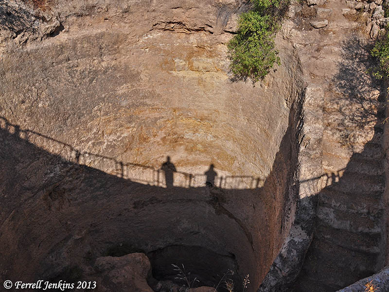
The pool had been constructed in the late 12th or early 13th century B.C. At first, it was thought to be a reservoir intended to hold water. Later it was learned that it served as a stairway leading to a source of water underneath the city.

After the destruction of Jerusalem by the Babylonians, the king of Babylon   made Gedaliah governor over the land. A rebellion led by a man named Ishmael killed Gedaliah at Mizpah (Jeremiah 41). The followers of Gedaliah and the men of Ishmael met at the great pool in Gibeon.

they took all their men and went to fight against Ishmael the son of Nethaniah. They came upon him at the great pool that is in Gibeon. (Jeremiah 41:12 ESV)

The great pool of Gibeon, cut from rock, measures 37 feet in diameter and 35 feet deep. Photo by Ferrell Jenkins.

The great pool of Gibeon, cut from rock, measures 37 feet in diameter and 35 feet deep. The steps led to the source of water located underneath. Photo by Ferrell Jenkins, whose shadow is visible, along with Leon Mauldin, standing at ground level.

For more information see James B. Pritchard’s Gibeon Where the Sun Stood Still (1962). For a ground level photo of the pool, see here.

Speaking at Florida College Annual Lectures

Tuesday morning at 10 a.m. I am scheduled to present an illustrated lecture on Biblical Coastal Towns of Turkey in Puckett Auditorium at the Florida College Annual Lectures. Normally in these sessions, in which I have participated in for many years, I present material on lesser-visited places that are important to Bible study.

There are several important coastal towns in Turkey that are mentioned in the Bible, mostly in connection with the journeys of Paul. These include Troas, Assos, Ephesus, Miletus, Patara, Myra, Attalia, Perga, and Seleucia. I have chosen to discuss two Black Sea cities (Sinope and Samsun) that are related to the discussion of the route of delivery of the Epistles of Peter, and to two cities on the Mediterranean Sea (Patara and Myra). I was able to visit all of these cities during the past year.

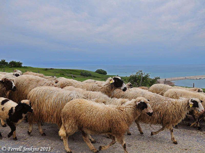
The photo below was made a few miles east of Sinope along the Black Sea (ancient Euxine). The territory is mountainous and the road is often far enough inland that the sea is not visible. Here the road runs along the sea, but still considerably above it. To the south, the mountains are much higher.

Sheep on the road east of Sinope, above the Black Sea. Photo by Ferrell Jenkins.

Sheep on the road east of Sinope, above the Black Sea. Photo by Ferrell Jenkins.

Nabatean town of Avdat restored

Avdat is located in the Wilderness of Zin, about 50 miles south of Beersheba. The beautiful ruins were vandalized about three years ago. Six different Israeli ministries invested nearly $2 million to repair the damage. The city has been designated by UNESCO as a world’s cultural heritage site.

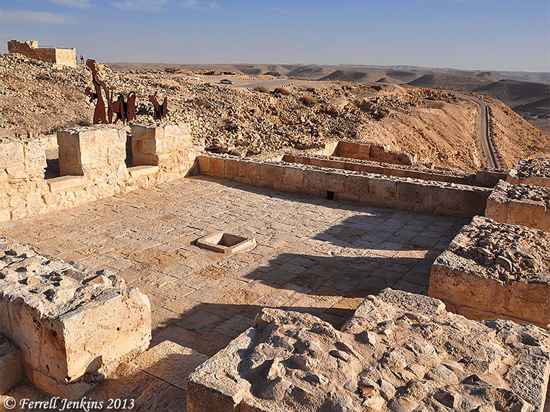
There are four wine presses at Avdat. The one I am showing below is a large Byzantine wine press.

Byzantine wine press at Avdat. Photo by Ferrell Jenkins.

Byzantine wine press at Avdat. Photo by Ferrell Jenkins.

Murphy-O’Connor describes the winepress.

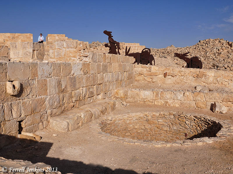
The winepress has a square treading area into which grapes were fed from small storage rooms on three sides. On the fourth side is a round pit into which the grape juice flowed via a channel under the treading floor from a central sump. – The Holy Land, 201.

The next photo shows the round pit.

The round pit into which the juice flowed. Photo by Ferrell Jenkins.

The round pit into which the juice flowed. Photo by Ferrell Jenkins.

I have never been able to take a group to Avdat, but I have made personal visits twice. See here and here.

For more information on the restoration see here.

Boxers in the Roman World

Our photo today is of a terracotta statuette of an African boxer. According to the sign accompanying the statuette, it is Roman, possible made in Italy.

The gloves are the Roman caestus, equipped with balls of lead to give a brutal blow.

Terracotta statuettes of African boxers. British Museum.

Terracotta statuette of an African boxer. British Museum. Photo by Ferrell Jenkins.

Paul used a boxing illustration to describe his own disciplined work in preaching.

So I do not run aimlessly; I do not box as one beating the air. But I discipline my body and keep it under control, lest after preaching to others I myself should be disqualified. (1 Corinthians 9:26-27 ESV)

Xanathos in Lycia

The photo I am sharing today was made at ancient Xanthos, a city of Lycia, now in southwestern Turkey. The city is situated in the Lycian mountains a few miles from the Mediterranean coast and the ancient city of Patara (Acts 21:1). The small town of Kinik lies in the valley below Xanthos.

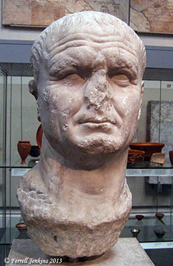
Roman Emperor Vespasian

Emperor Vespasian. BM. Photo by F. Jenkins

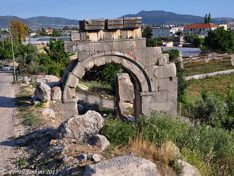
A road runs up the hill through the ancient ruins. One of the first monuments we come to is a Roman arch dedicated to the emperor Vespasian  (A.D. 69-79) by the Council and People of Xanthos. George E. Bean says,

The pavement which survives in part belongs to an ancient road which led up from Patara and the Letoum. – Lycian Turkey, 60.

Our view is made from above the arch. To the left you can see the narrow modern road leading to the parking lot at Xanthos.

Arch built by Vespasian partially below modern road level. Photo by Ferrell Jenkins.

Arch built by Vespasian partially below modern road level. Photo by Ferrell Jenkins.

This photo illustrates the build up of debris over the centuries.

Writers such as Bean tell of the time when the Persians conquered western Asia about 540 B.C. Rather than surrender, the fighting men of Xanathos placed their women, children, slaves, and property on the acropolis and set fire to it. These men then went forth and fought to the death.  This account reminds us of the one recorded by Josephus about the fall of Masada during the Jewish Wars against the Romans (The Jewish War 7.8.6).

For more information about Xanathos, and Lycia in general, see the nice Lycian Turkey website here.

Monument from Xanathos now in British Museum

The ancient Greek city of Xanthos (Xanthus) is mentioned in the Iliad as the greatest of the cities of Lycia. The site is located near Letoon, and a few miles north of Patara, the port where the Apostle Paul changed ships on the return from the Third Journey (Acts 21:1-2).

Our visit to Xanathos was limited due to the lateness of the day, but we took time to get a few photos of some significant ruins. Our first stop was what the Blue Guide Turkey calls “the few sad remains of the Nereid Monument.”

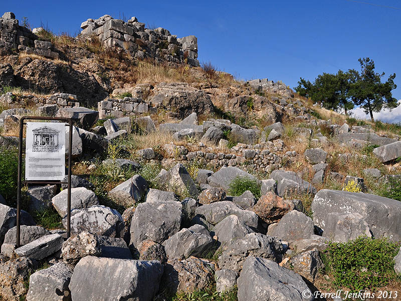
Xanathos_site-of-Nereid-Mon_fjenkins052012_043t

The site of the Nereid Monument at Xanathos. Photo by Ferrell Jenkins.

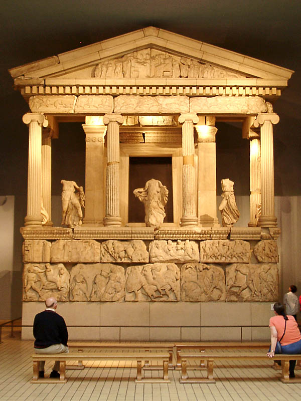
Charles Fellows took statues and friezes from the Monument to the British Museum in 1841-42, where they have been reconstructed.

Nereid Monument in British Museum. Photo by Ferrell Jenkins.

Nereid Monument in the British Museum. Photo by Ferrell Jenkins.

The sign at the original site (visible in the first photo) says,

This famous classical era monument was removed in its entirety to the British Museum in the last century [an old sign] and all that remains are a few rows of stones from the foundations and podium. This 4 by 6 columns Ionic temple style monument is embellished with reliefs and statues [sic]. The statues of twelve females between the columns are those of water spirits known as Nereids.

The Monument dates as early as 390 B.C.

The new Satellite Bible Atlas

Todd Bolen announced Monday the publication of the Satellite Bible Atlas. This new work is by Bill Schlegel, Associate Professor of the Bible at IBEX in Israel. Bill has lived and taught in Israel since 1984. He taught at the Jerusalem University College (formerly the Institute of Holy Land Studies) before joining The Master’s College IBEX program in 1995.

According to Bolen,

This resource is ready for personal use, classroom use, and field trip use. The author, Bill Schlegel, has been teaching college and seminary students in Israel for 25 years. Everything in the Satellite Bible Atlas is field-tested by a professor who knows God’s land and loves God’s Word.

He continues to give 7 additional reasons why he loves the Satellite Bible Atlas. I will leave it for you to read more details at the Bible Places Blog here.

sba2000c-t

I have had the opportunity for several days to see the various materials associated with the Satellite Bible Atlas, but late Monday I received my beautiful copy and have found it to be an amazing production.

After 17 pages of beautiful satellite maps, the additional maps are printed on one page with a brief, numbered, commentary on the opposite page. For example, looking at map 5-1, Samuel’s Ministry, we see a marked map of the portion of the land where Samson was born, and the places of his activity. Map 9-4 shows Jesus’ Move from Nazareth to Capernaum. Map 10-1 shows Acts of the Apostles in Israel. While the emphasis is on the Promised Land and the history of Israel, Jesus and the Early Church, there are maps showing the Journeys of Paul, The First Revolt Against Rome (c. 66-73 AD), the Bar Kochva Revolt, Jerusalem, the modern Middle East, etc. Eighty-five maps in all.

This beautiful book is published in Israel. I am surprised that the book is available for $30 plus tax and $3 shipping (in the U.S.). You will also be granted access to download the maps.

More information and ordering instructions are available here. Sample Maps, Commentary, Study Questions, and an Index to Sites, are available for download. There are also some Teaching Videos, and more are expected from time to time.

“Every man under his vine” again

A few days ago I wrote here about a biblical way of describing a time of peace and prosperity.

And Judah and Israel lived in safety, from Dan even to Beersheba, every man under his vine and under his fig tree, all the days of Solomon. (1 Kings 4:25 ESV)

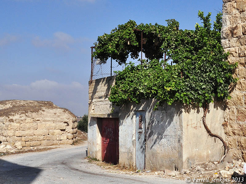
I mentioned that it is not uncommon in the Middle East to see a vine running up the side of a house to cover a porch on the roof. Since the last post I located one of my photos showing this practice. This photo was made at El Jib, the site believed to be Gibeon (Joshua 9; 2 Samuel 2).

A vine growing up the side of a house to provide shade on the roof. Photo by Ferrell Jenkins at Gibeon.

A vine growing up the side of a house to provide shade on the roof. Photo by Ferrell Jenkins at Gibeon (El Jib).