Category Archives: Travel

Reading the blogs #2

Michael G. Hasel of Southern Adventist University will join Yosef Garfinkel and Martin G. Klingbeil as co-directors of The Lachish Expedition in 2014. Southern has begun a web site devoted to the dig here. Categories include Project Overview, Goals and Strategy, History of Research, and Staff. We wrote about the Lynn H. Wood Archaeological Museum, at Southern, here.

The Judean fort at Lachish. Photo by Ferrell Jenkins.

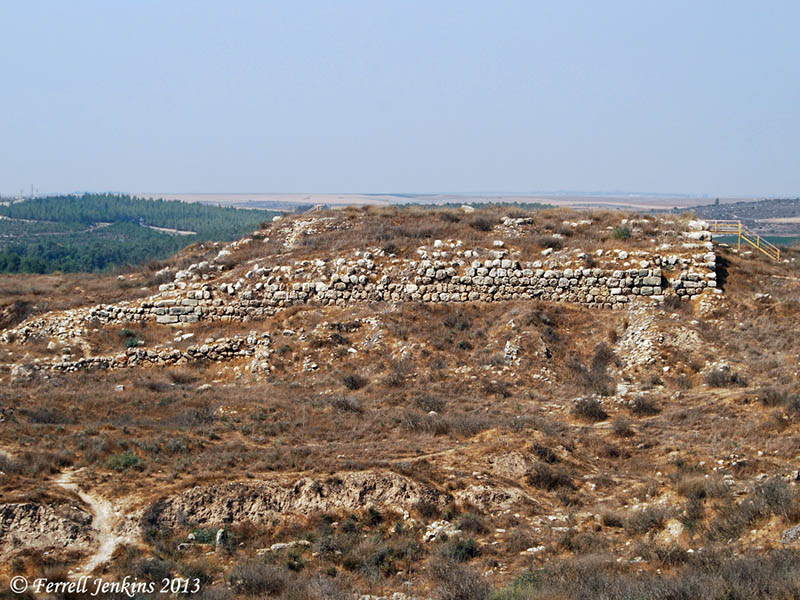
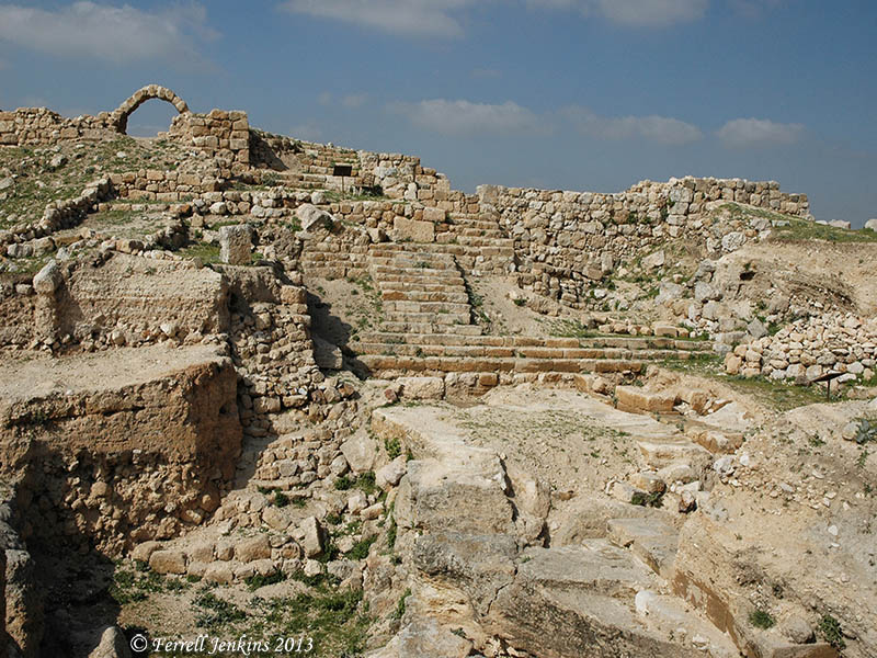
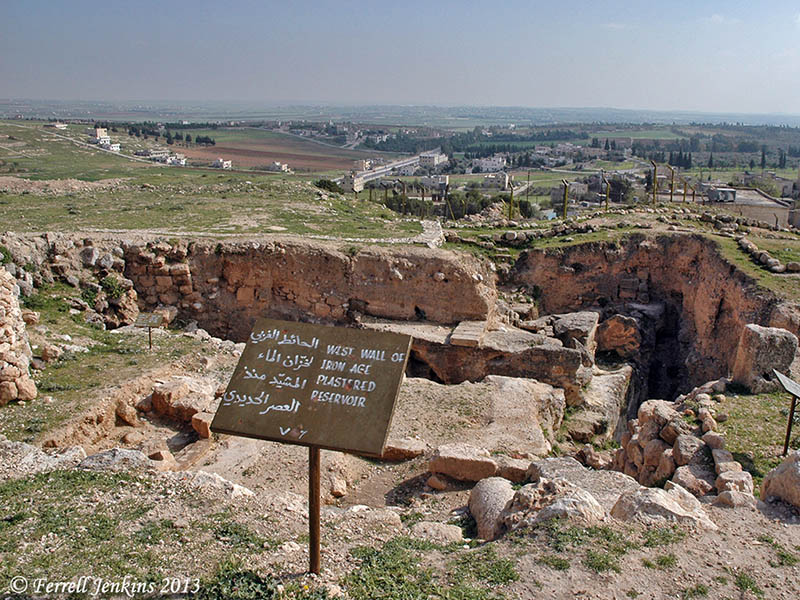
The Judean palace-fort at Lachish is the largest Iron Age structure in Israel. Photo by Ferrell Jenkins.

Associates for Biblical Research announced here the death of ABR founder Dr. David Livingston. An issue of Bible and Spade devoted to the work of Dr. Livingston has been made available in PDF. Dr. Livingston gave much attention to locating Biblical Ai. I am hopeful Ancient Days, the web site devoted to his writings, will be maintained here.

Check ORBIS here. This is the Stanford Geospatial Network Model of the Roman World. Lot’s of possibilities here in studying Paul’s journeys.

The BBC reports on how some maps of the modern Middle East were drawn here.

Tom Powers has left Jerusalem for North Carolina. Hopefully he will maintain his View From Jerusalem web site. Now would be a good time to check “My Articles” and download his research material on the ancient aqueduct system, Conrad Schick, American Colony, and some ossuaries.

My friend Steve Wolfgang is trained as a historian and is a minister with a wide range of interests. This is reflected in his blog, ἐκλεκτικός.

I enjoy Larry Hurtado’s Blog. Check “Where did Earliest Christians Meet?” here. If you thought they always met in private homes, you might learn something.

One of my favorite blogs, checked regularly, is Charles Savelle’s Bible X, a blog devoted to all things Bible Exposition. Charles surveys material helpful to teachers and ministers. He recently included a link to online tools for creating Infographics, Self-Editing for Better Writing, and lots of brief book reviews.

I like to check on Dr. Rod Decker’s NT Resources. Rod has been diagnosed with cancer. One of his colleague’s is dealing with TN — “a nonterminal condition that produces some of the most excruciating pain known to medical science, and that on a very frequent basis.” Recently the two of them spoke in chapel before their students on the general theme “When Your World Crashes Down.” Their comments are available for download.

For sure I have mentioned Biblical Studies and technological Tools by Mark Hoffman. This is a great resources. The most recent post evaluates online backup and data syncing options.

For a few years now I have been using Dropbox for syncing material between my study computer and my traveling laptop. If you click here you will get 2.25 gig free, and I will get .25 gig addition. Click here.

Reading the blogs

The majority of the content of this blog deals with biblical studies, archaeology, travel and photography. Concentration is especially on travel in the Bible World. As a result of this I follow several blogs that are extremely helpful. These include:

Bible Places Blog. Todd Bolen’s Weekend Roundup, and Midweek Roundup are extremely helpful, as are his insightful comments on recent archaeological announcements.

HolyLandPhotos’ Blog by Carl Rasmussen covers numerous lesser known places. Recently he has covered some sites visited, or probably visited, by Paul on his journeys through Asia Minor (modern Turkey).

The wilderness of Judea. Photo by Ferrell Jenkins.

The wilderness of Judea. Photo by Ferrell Jenkins.

I have a few former students  who write about these areas. You might enjoy taking a look at Leon’s Message Board (Leon Mauldin), Exploring Bible Lands (Barry Britnell), Luke Chandler’s Blog. Leon recently posted photos of the gathering of olives at Shechem. Trent and Rebekah, former tour members, have posted some helpful articles during their six months in Israel.

Gordon Franz writes less frequently on his Life and Land Seminars, but most of his material reflects a considerable amount of research. As part of his ongoing Cracked Pot Archaeology series he posted a response to the theory that the Arabia of “Mount Sinai in Arabia” (Galatians 4:25) is in modern Saudi Arabia.

Leen Ritmeyer,  Ritmeyer Archaeological Design, writes about the way the buildings looked in Bible times as well as recent discoveries and developments.

Wayne Stiles seeks to connect the Bible and its Lands to Life. In a recent post he discussed the “Top 5 Gifts for Bible Lands Study.”

Shmuel Browns, Israel-tourguide, has an interesting blog with great photos. A recent post features fascinating photos of Nahal Prat or Wadi Qelt. This may be where Jeremiah was told to go and bury his loincloth (shorts) (Jeremiah 13:4-7). Most English versions use the word Euphrates for the Hebrew term Perath. The NET Bible transliterates the term. Nahal Prat is near Jeremiah’s hometown Anatot (Anathoth). We wrote about a morning with Shmuel here.

Recently I learned of two new blogs dealing with the Bible lands and customs. Mark Ziese writes Bible Lands Explorer. Mark’s most recent post is about the Milk Grotto in Bethlehem. Yep, a place dedicated to Mary feeding baby Jesus. Willis Britt writes on Lessons From The Land. A recent series deals with Preaching and the Land.

Believe me, there is quite an education in reading these blogs.

I keep links to these and other blogs on the Scholarly page at the Biblical Studies Info Page.

Elah River flooding at Tell es-Safi/Gath

Several times we have commented on the wonderful photos supplied by Prof. Aren Maeir about the archaeological excavations at Tell es-Safi/Gath, both during the season and throughout the year.

For the past two days Maeir has posted photos of the Elah River flooding at Safi/Gath. English readers will relate to the word brook. The Hebrew is nahal. This is the same brook we read about in the account of David choosing five smooth stones when he went to fight Goliath (1 Samuel 17:40). The term used here is equivalent to the Arabic wadi.

A stream like this is dry most of the year, but flows freely during the rainy, winter season.

The photo below is from the Tell es-Safi/Gath blog here. It was made by Uri Yehuda, a student in Prof. Maeir’s department at Bar Ilan University. Those who have visited Gath during the dry season should find it instructive.

Flooding of the Elah River next to Safi. Photo by Uri Yehuda.

Flooding of the Elah River next to Safi. Photo by Uri Yehuda.

You may locate this photo in hi-resolution, and another made by Aren on the blog. The best picture may be in video format with a young lady telling us it is the “flood of December.” The link to all of this material is here.

The Brook of Elah begins below Adulam, flows through the valley bearing its name, around Azekah, past Gath, and into the Mediterranean Sea.

In the aerial photo below you will see Tell es-Safi/Gath just to the left of the center of the photo. The Elah River (Brook) can be seen in the lower right corner of the photo. This photo was made December 15, 2009. The river bed is green because there had been earlier rains, but nothing like the recent storm seen in Israel.

Aerial view of Gath and the Elah Brook. Photo by Ferrell Jenkins.

Aerial view of Gath and the Elah Brook. Photo by Ferrell Jenkins.

A snow house in Jerusalem

Elie sent me a photo he made this morning of a snow house in Jerusalem. If you know Jerusalem you know that the houses are built of stone (some of Jerusalem stone). The person building this snow house made it in imitation of the stone houses. It’s always good to have police protection!

Snon house in Jerusalem appears to be made of snow stone. Photo by EMB. Dec. 16, 2013.

Snow house in Jerusalem appears to be made of snow stone. Photo by EMB. 12/16/13.

Benaiah the son of Jehoiada, one of David’s mighty men “went down and struck down a lion in a pit on a day when snow had fallen” (1 Chronicles 11:22 ESV)

The fourth archaeological expedition to Tel Lachish

Announcement has been made through various sources of the anticipated fourth archaeological expedition to Tel Lachish. Archaeologists who have been working at Khirbet Qeiyafa (the Elah Fortress), Yosef Garfinkel, Michael Hasel, and Martin Klingbeil, announced a new excavation at Lachish in the Nov./Dec. 2013 issue of Biblical Archaeology Review. BAR has made available a collection of seven articles dealing with the third excavation (1974-1984) under the direction of Prof. David Ussishkin.

These links may be broken in the near future, but if you have access to the BAR on CD or Logos this may serve as a helpful bibliography.

Lachish is thought to be the second most important city of Judah after Jerusalem. This is based on the fact that both the Assyrians and the Babylonians destroyed the city immediately before moving to Jerusalem. Rehoboam (931-913 B.C.) built Lachish and other cities in Judah for defense (2 Chronicles 11;5-9). Other kings fortified them to be used for the storage of food, oil and wine.

Our photo below shows Tel Lachish from the air. In the bottom left quarter (south west) of the photo you will see a small parking lot with a path leading through them to the gate of the city. To the right of the path, beginning at the grove of trees you will see the siege ramp built by Sennacherib, king of Assyrian, in 701 B.C. The photo also shows the defensive Judean counter-ramp found in the 1983, and described by Ussishkin in the 1984 article.

Tel Lachish from the air. Photo by Ferrell Jenkins.

Tel Lachish from the air. Photo by Ferrell Jenkins.

The previous excavations at Tel Lachish (earlier called Tell ed-Duweir) are,

  • A British expedition directed by James L. Starkey and Olga Tufnell – 1932-1938
  • Israeli expedition directed by Yohanan Aharoni, Tel Aviv University, 1966, 1968

Use the Search box to locate other entries on Lachish.

HT: Steven Braman

Zondervan Essential Atlas of the Bible

Frequently we have mentioned and recommended the Zondervan Atlas of the Bible by Carl G. Rasmussen. Every Bible student needs at least one or two good atlases to assist them in their study of the Scriptures.

Last month I attended some annual professional meetings in Baltimore and was pleased to see that Zondervan already had copies of the new Zondervan Essential Atlas of the Bible. One of the sales reps gave me a copy for review here.

At first appearance, the ZEAB has a beautiful cover of stiff, durable paper. It is a convenient 9 1/8″ x 7 3/8″ in size. The content is basically the same as the larger hard back edition. There has been some editing of the text to condense the book from 303 pages to 159 pages.

There are two major sections to the book: Geographical Section and Historical Section. The Geographical Section includes an Introduction to the Middle East as a Whole, and discusses the geography of Israel and Jordan, Egypt, Syria and Lebanon, and Mesopotamia.

The Historical Section covers the entire Bible from the Pre-Patriarchal Period to the Seven Churches of Revelation, with an additional chapter on Jerusalem, in 17 chapters.

The maps are superbly drawn and easy to read. A timeline accompanies each chapter. Rasmussen is noted for his Holy Land Photos web site. The photos are beautiful and helpful in illustrating the content.

This book has been prepared by a teacher, and I consider that a plus. In addition to his work at Bethel University, Carl continues to serve as an adjunct professor at Jerusalem University College. He has spent 16 years of his adult life in the Bible lands. His  Holy Land Photos’ Blog provides helpful, up-to-date, information about both familiar and unfamiliar places mentioned in the Bible. He has also led numerous tours through Bible lands.

This Atlas sells for $16.99. I see that Amazon has the Zondervan Essential Atlas of the Bible for $12.97. A Kindle version is about $3 less.

Either version is ideal for a person to take with them to Bible class, or on a tour of Bible lands.

The larger Zondervan Atlas of the Bible still remains indispensable for the serious student. I am trying to say you should have both books.

Carl has assisted me on several occasions in locating some of those hidden, out-of-the-way, places that most visitors to the Bible lands never see. I am pleased to commend this new edition of his book.

Scenes around Tell Ḥesbân (Heshbon)

The photo below was made from the top of Tell Ḥesbân in Transjordan. It provides us a view of the general area of Moab during the period of the United Kingdom of Israel, and the Divided Kingdoms of Israel and Judah.

Sheepfold on the slope of Tell Ḥesbân. View of territory of Moab. Photo by Ferrell Jenkins.

Sheepfold on the slope of Tell Ḥesbân. View of territory of Moab. Photo by Ferrell Jenkins.

There are several biblical references to the sheepfold, or the fold of the sheep (Jeremiah 50:6; Micah 2:12; John 10:1, 16). Jesus used an illustration involving the sheepfold:

Truly, truly, I say to you, he who does not enter the sheepfold by the door but climbs in by another way, that man is a thief and a robber. But he who enters by the door is the shepherd of the sheep. (John 10:1-2 ESV)

We associate the land of Moab with Ruth the grandmother of King David.

So Naomi returned, and with her Ruth the Moabitess, her daughter-in-law, who returned from the land of Moab. And they came to Bethlehem at the beginning of barley harvest. (Ruth 1:22)

I find it fascinating that the modern locals pick up on the ancient names in order to attract the tourists who visit the area. At Madaba, about six miles south of Ḥesbân, there is a small hotel named Mo’ab Land Hotel. How appropriate.

The Moab Land Hotel in Madaba, Jordan. Photo by Ferrell Jenkins.

The Moab Land Hotel in Madaba, Jordan. Photo by Ferrell Jenkins.

If not Tell Ḥesbân, where is Heshbon?

If Tell Ḥesbân is not biblical Heshbon, then the pool uncovered by S. H. Horn is likely not the pool mentioned in Song of Solomon 7:4.

If Tell Ḥesbân is not biblical Heshbon, then where is biblical Heshbon?

A sign at Tell Ḥesbân, erected by the excavators, lists evidence of occupation during the following periods:

  • Ajarmah [local tribe] village – ca. AD 1870-present
  • Ottoman Village
  • Mamuluk Regional capital – AD 1260-1500
  • Abbasid pilgrim rest. – AD 750-1260
  • Umayyad market town – AD 650-750
  • Byzantine Ecclesiastical center – ca. AD 350-650
  • Roman temple town – ca. 63 BC – AD 350
  • Hellenistic fortress – ca. 198 BC – 63 BC
  • Ammonite citadel – ca. 900 – 500 BC
  • Proto Ammonite village – ca. 1200 – 900 BC
  • Traditional Ammorite Stronghold.
Roman steps and market area at Tell Ḥesbân. Photo by Ferrell Jenkins.

Roman steps and market area at Tell Ḥesbân. Photo by Ferrell Jenkins.

Remember that we are looking for a town of Moab, and there is no evidence of the Moabites at Tell Ḥesbân.

Because not every reader of this blog speaks Bronze Age and Iron Age, I think I should list the general dates of these archaeological periods (following J. A. Thompson, The Biblical World (ed. Charles Pfeiffer).

  • Early Bronze (EB) — ca. 3200 – 2100 BC
  • Middle Bronze (MB) — ca. 2100 – 1550 BC – period of the Patriarchs
  • Late Bronze (LB) — ca. 1550 – 1200 BC – period of Moses, the Exodus, and the Conquest
  • Iron I — ca. 1200 – 900 BC – period of the Judges & the United Kingdom
  • Iron II — ca. 900 – 600 BC – period of the Divided Kingdom
  • Iron III — ca. 600 – 300 BC – period of Exile and Return
  • Hellenistic (Grecian) — ca. 300 – 63 BC – Between the Testaments
  • Roman — ca. 63 BC – AD 323 – New Testament & early Christian period

We are looking for a city belonging to the period of Moses, the Exodus, and the Conquest (the Late Bronze archaeological period). [*see note below]

After the disappointment at Tell Ḥesbân, those associated with Horn formed the Madaba Plains Project in order to continue the search for Heshbon. One of the great things about Todd Bolen’s Pictorial Library of Bible Lands is the fact that many of the photos include brief documentation with the photos. With one of the Tell Ḥesbân photos he says,

After this disappointing series of digs, the Madaba Plains Project was formed and the search for Heshbon continued.  Four Late Bronze sites were found within a 6 mile (10 km) radius of Tel Hesban; Tel Jalul is the biggest and thus the most promising site. Tel Jalul is the largest site in Jordan south of Amman.
Three possibilities exist for the location of biblical Heshbon: Tel Hesban, Tel el-Umeiri, and Tel Jalul. Hesban preserves the name, which makes it a good candidate, but it lacks archaeological evidence.
The PLBL collection includes photos of all of these places. The Institute of Archaeology Siegfried H. Horn Museum at Andrews University maintains a helpful web site that includes information about the Madaba Plains Project here.
Byzantine church at Tel Hesban. Photo by Ferrell Jenkins.

Byzantine church at Tel Hesban. Photo by Ferrell Jenkins.

The photo above shows the ruins of the Byzantine church at Tell Ḥesbân. Tel Jalul may be seen in the distance. Look for the long, plain “hill”, on the top of the hill on the far left of the photo.
Added Note: In the original post I stated that “We are looking for a city belonging to the period of the Patriarchs (the Late Bronze archaeological period).” A friend called my attention to the oversight. The chart above shows that the period of the Patriarchs is the Middle Bronze Age. I should have said, as now corrected above, that “We are looking for a city belonging to the period of Moses, the Exodus, and the Conquest (the Late Bronze archaeological period).”

Is Tell Ḥesbân Heshbon?

S. H. Horn describes the biblical significance of Heshbon.

A city of Transjordan strategically located at the main north-south road, called the King’s Highway in the Bible, some 15 mi. (c. 24 km.) southwest of “Amman (Palestine Under Joshua and the Judges). The Israelites captured it from Sihon, an Amorite king, who had taken it from the Moabites and made it his capital (Num 21:25–30). The city was given to the Reubenites and rebuilt by them (Num 21:34; 32:37; Jos 13:17). However, since it lay on the border between Reuben and Gad, the latter tribe seems eventually to have occupied it (Jos 13:26). It was later assigned, as a town of Gad, to the Levites (Jos 21:39; 1 Chr 6:81). The Moabites reconquered the city in the period of the divided kingdom and occupied it in the time of Isaiah and Jeremiah (Is 15:4; 16:8, 9; Jer 48:2, 33, 34). However, during Jeremiah’s lifetime it seems to have changed hands again, since he refers to it as an Ammonite city in one of his later oracles (Jer 49:2, 3). The Ammonites seem to have taken it during an invasion of the Moabite territory referred to in Ezekiel (ch 25:9, 10). It was in the possession of Alexander Jannaeus in the time of the Maccabees, and was later ruled by Herod the Great (Jos. Ant. xiii. 15. 4; xv. 8. 5), who fortified it and made it into a garrison city called Esbus. Later it became a Christian city and seat of a bishop. Several bishops of Heshbon are known by name. In 614 the city suffered greatly during the Persian invasion, when its 3 churches—so far excavated—were destroyed. The Arabs who some 20 years later occupied the country made the city, then called Ḥesbân, the capital of the district. After the 13th cent. the city is never mentioned again.

Excavations were conducted at Tell Ḥesbân under the direction of Siegfried Horn and Larry Gerarty from 1968 to 1976. A large open-air reservoir dating to the Iron Age, the period of the Israelite kings was uncovered. The pool measured about 50 ft. x 50 ft., and was 18 ft. deep. It was large enough to hold 300,000 gallons of water.

The Iron Age Pool at Heshbon. Photo by Ferrell Jenkins.

The Iron Age Plastered Reservoir at Heshbon. View West. Photo by Ferrell Jenkins.

Horn says this was “probably a pool to which Song 7:4 refers.”

Your neck is like an ivory tower.
Your eyes are pools in Heshbon,
by the gate of Bath-rabbim.
Your nose is like a tower of Lebanon,
which looks toward Damascus. (Song of Solomon 7:4)

I have followed the information by S. H. Horn in The Seventh-day Adventist Bible Dictionary. In a post to come I hope to explain why Tell Ḥesbân may not be biblical Heshbon.

The Moabite city of Elealeh

Elealeh (pronounced EL e A lah) is one of those little known cities from Bible times. It is now identified as Tell (or Tall) Al-Elealeh. The mound is located about two miles northeast of Heshbon.

When we first encounter the city of Elealeh it belongs to the Moabites. After the Israelites occupied the area the city was given to the tribe of Reuben as part of their territory (Numbers 32:3, 37).

Map showing Elealeh in Moab. BibleAtlas.org.

Map showing Elealeh in Moab. BibleAtlas.org.

The Seventh-day Adventist Bible Dictionary gives this brief information about the city.

A town which the Israelites took from the Amorite king of Heshbon, and which the Reubenites rebuilt (Num 32:3, 37). Later, when the Moabites extended their territory to the north, they reoccupied it (Is 15:4; 16:9; Jer 48:34). It is now el–‘Al, a ruin on top of a hill, 3,082 ft. (940 m.) above sea level, about 2 mi. (c. 3 km.) northeast of Heshbon (Palestine Under Joshua and the Judges). Archeological soundings were conducted at el–‘Al by W. L. Reed in 1962. The excavated evidence indicated that the ancient city had existed from the 3d millennium B.C. down to the Middle Ages with a possible gap in occupation from 1600–1200 B.C. since no Late Bronze Age remains were found. (Horn, Siegfried H. The Seventh-day Adventist Bible Dictionary 1979 : 318.)

The site of ancient Elealeh. Photo by Ferrell Jenkins.

The site of ancient Elealeh. Photo by Ferrell Jenkins.