
Frankincense and myrrh are mentioned together in the Song of Solomon and in the account of the visit of the magi from the east to see Jesus. Several significant things can be learned from these Biblical verses.
Look first at Song of Solomon 3:6.
“What is this coming up from the wilderness Like columns of smoke, Perfumed with myrrh and frankincense, With all scented powders of the merchant? (Song of Solomon 3:6 NAU)
- Myrrh and frankincense are associated with the wilderness (desert; Hebrew, midbar).
- Perhaps incense used in sacrifice or offering, “like columns of smoke.”
- Associated with perfume and scented or fragrant powders.
- Something traveling merchants would bring from the wilderness.
Song of Solomon 4:13-14 provides more insights.
“Your shoots are an orchard of pomegranates With choice fruits, henna with nard plants, Nard and saffron, calamus and cinnamon, With all the trees of frankincense, Myrrh and aloes, along with all the finest spices. (Song of Solomon 4:13-14 NAU)
- Associated with trees, and classified with spices.
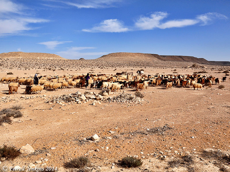
The wilderness of Zin near Avdat. Photo by Ferrell Jenkins.
The reference in the New Testament is in the account of the birth of Jesus (Matthew 2:1-11).
- Frankincense and myrrh are in the category with gold, and offered as gifts to one who is considered a king and is being worshiped.
- The magi have come from east of Jerusalem and Bethlehem.
- Gold, frankincense, and myrrh are considered treasures.
All of these tips harmonize with what is known about frankincense and myrrh. The plants or trees from which these come are known to grow in the desert regions. They are not native to Biblical Israel. Traveling merchants from Arabia traveled long distances across the desert, making stops at Petra, Avdat, and other places on their way to Gaza and other Mediterranean ports where the products could be shipped throughout the Mediterranean world.
The photo below was made at Avdat (Ovdat), a Nabatean site in the Negev. The city was especially significant in the first century B.C. and the first century A.D. Avdat was stop number 62 on the famous Incense Route. It is now part of Israel’s National Park system, and a World Heritage Site. A display at the ticket office and shop explains about the Incense Route and shows some of the goods that were transported across the desert.
The header we are using for this blog, showing a caravan crossing the desert, was made at Avdat.
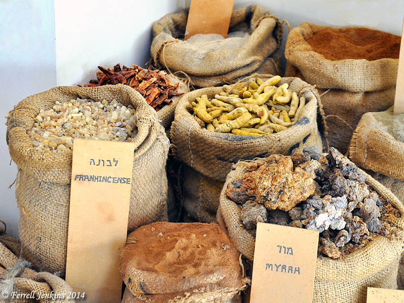
Frankincense and Myrrh on the Spice Route at Avdat. Photo by Ferrell Jenkins.
This post is a revision of one posted December 14, 2011.


You must be logged in to post a comment.