Tag Archives: Golan Heights

Birket Ram on the road to Trachonitis

Birket Ram is located north of Mas’ada in the Golan Heights (now Northeastern Israel; formerly Syria). Using two 18mm images I was able to make this panorama. Click on the photo for a larger image.

Panorama of Birket Ram. Photo by Ferrell Jenkins.

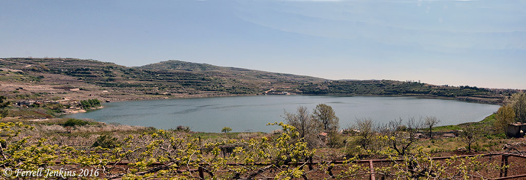
Panorama (view south) of Birket Ram. Photo by Ferrell Jenkins.

Birket Ram is not mentioned in the Bible, but there is some related historical information.

Azaria Alon devotes only a single paragraph to Birket Ram, or Ram Pool.

Birket Ram is a natural water formation which measures 600 x 900 meters [1,968 x 2,952 ft.], reaches a depth of 6 to 10 meters [20 to 30 ft.], and holds about 3 million cubic meters of water. The pool has the appearance of a crater and is at an elevation of 940 meters [3,083 ft.]. It contains sweet water fed by underground springs and rain. Geologists believe that the pool was formed by volcanic activity in which the peak of the mountain blew off leaving a crater. (Israel National Parks & Nature Reserves, 2008. p. 39).

Josephus states that Panium [Paneas or Banias = Caesarea Philippi] is thought to be the source of the Jordan River. He claims, however, the source is Phiale (Birket Ram).

509 Now Panium is thought to be the source of the Jordan, but in reality it is carried there after a hidden manner from the place called Phiale:
510 this place lies as you go up to Trachonitis, and is fifteen miles from Caesarea, and is not far out of the road on the right hand;
511 and indeed it has its name of Phiale [vial or bowl] very justly, from the roundness of its circumference, as being round like a wheel: its water continues always up to its edges, without either sinking or running over;
512 and as this origin of Jordan was formerly not known, it was discovered when Philip was tetrarch of Trachonitis [Luke 3:1];
513 for he had chaff thrown into Phiale, and it was found at Panium, where the ancients thought the source of the river was, where it had been therefore carried [by the waters]. (Jewish Wars 3:509-513)

In 1865 Edward Robinson questioned the claim of Josephus saying,

This story helps to confirm the identity of Phiala with Birket er-Râm; but the supply of such a fountain as that of Bâniâs would exhaust this lake in a single day. (Physical Geography of the Holy Land)

Contrary to Alon’s claim that the water of Birket Ram is sweet, Robinson and other older sources say that the water is stagnant and slimy. I got no closer than the photo shows and can not testify about the quality of the water.

Mount Arbel and the Sea of Galilee

Our photo today was made from NW of the Sea of Galilee. The formation on the right is known as Mount Arbel. The agricultural area you see slopes down to the Plain of Gennesaret which stretches about 2½ miles to the Sea (Matthew 14:34).

View of Mount Arbel and the Sea of Galilee from the NW. Photo by Ferrell Jenkins.

View of Mount Arbel and the Sea of Galilee from the NW. Photo by Ferrell Jenkins.

Across the Sea of Galilee is a portion of the Golan Heights, known in Old Testament times as Bashan. This territory was taken by Israel from Og the king of Bashan and eventually became territory belonging to the tribe of Manasseh.

Then they turned and went up by the way to Bashan. And Og the king of Bashan came out against them, he and all his people, to battle at Edrei. But the LORD said to Moses, “Do not fear him, for I have given him into your hand, and all his people, and his land. And you shall do to him as you did to Sihon king of the Amorites, who lived at Heshbon.” So they defeated him and his sons and all his people, until he had no survivor left. And they possessed his land. (Numbers 21:33-35 ESV)

A city within the territory of Bashan was named Golan, and became one of the Israelite Cities of Refuge (Joshua 20:8).

Mount Arbel has its own history outside the Biblical text, but I will save that for another time.

Horses in the Golan Heights

Last September we stopped in the Golan Heights at the overlook east to Kuneitra, Syria. A few horses were being pastured in the area. Mount Hermon is visible to the north.

Horses in the Golan Heights. Mount Hermon in the distance. Photo by Ferrell Jenkins.

Horses in the Golan Heights. Mount Hermon in the distance. Photo by Ferrell Jenkins.

This area is included in the description of the victories of the Israelites.

Now these are the kings of the land whom the people of Israel defeated and took possession of their land beyond the Jordan toward the sunrise, from the Valley of the Arnon to Mount Hermon, with all the Arabah eastward: (Joshua 12:1 ESV)

Fires damages Gamla Nature Reserve

The nature reserve at Gamla has been severely damaged, according to a Haaretz report here.

Israel’s nature and parks authority believed the blaze was started by a military tank, whose metal tracks gave off sparks when moving over rocks.

Gamla is an impressive fortress east of the Sea of Galilee. It is not mentioned in the New Testament, but Jewish zealots were defeated here by the Roman army about A.D. 66. Josephus describes the site in vivid terms:

for it was located upon a rough ridge of a high mountain, with a kind of neck in the middle: where it begins to ascend, it lengthens itself, and declines as much downward before as behind, insomuch that it is like a camel in figure, from where it is so named, although the people of the country do not pronounce it accurately. Both on the side and the face there are abrupt parts divided from the rest, and ending in vast deep valleys; yet are the parts behind, where they are joined to the mountain, something easier of ascent than the other; but then the people belonging to the place have cut an oblique ditch there, and made that hard to be ascended also. On its slope, which is straight, houses are built, and those very thick and close to one another. The city also hangs so strangely, that it looks as if it would fall down upon itself, so sharp is it at the top. (Wars of the Jews 4:5-7)

A view of the site while reading the description by Josephus will probably be helpful.

Gamla. Photo by Ferrell Jenkins.

Gamla. Photo by Ferrell Jenkins.

The photo below shows a canyon near the ancient site. From this concrete lookout tourists look for soaring eagles which are common in the reserve.

Viewing Gamla in 2008. Photo by Ferrell Jenkins.

Looking for Eagles in 2008.

The photo below from Haaretz shows the same concrete observation building after the fire. Be sure to check the article to see more photos of the damage caused by the fire.

Gamla Nature Reserve Fire. Haaretz. May 27, 2010. Yaron Kaminsky.

Gamla Nature Reserve Fire. Photo: Haaretz, Yaron Kaminsky.

This photo will give you a good view of the area as we saw it from the lookout near the end of August, 2008.

Gamla Nature Reserve. Photo by Ferrell Jenkins, Aug. 30, 2008.

Gamla Nature Reserve. Photo by Ferrell Jenkins, Aug. 30, 2008.

HT: Bible Places Blog.

“You cows of Bashan”

Amos of Tekoa is recognized as a straight forward, no nonsense, prophet (Amos 1:1). He called the women of the northern kingdom of Israel cows. Nothing politically correct about that.

Hear this word, you cows of Bashan who are on the mountain of Samaria, Who oppress the poor, who crush the needy, Who say to your husbands, “Bring now, that we may drink!” (Amos 4:1)

The sn (study note) in the NET Bible is worth reading.

The expression cows of Bashan is used by the prophet to address the wealthy women of Samaria, who demand that their husbands satisfy their cravings. The derogatory language perhaps suggests that they, like the livestock of Bashan, were well fed, ironically in preparation for the coming slaughter. This phrase is sometimes cited to critique the book’s view of women.

Bashan is in the area we now call the Golan Heights. It is located to the east of the Sea of Galilee and northward. Golan in Bashan was one of the cities of refuge located in the territory of eastern Manasseh (Joshua 20:8). The region was noted as good pasture land.

In the modern state of Israel we notice an attempt to grow crops known from biblical times in the same area where they were grown then. And the same is true of cattle. Here is a photo I made this year of some of the cows grazing in ancient Bashan (modern Golan Heights).