Category Archives: Jordan

Looting and vandalism in Petra

Looting and vandalism of historic or archaeological sites is nothing new. We have reported on vandalism in Israel, but especially in the war-torn countries of Syria and Iraq.

Heritage Daily has an article here on looting and vandalism at Petra. Petra was designated a UNESCO World Heritage Site in 1985. Archaeologists from Brown University have been working in Petra since 2009. They have been able to photograph excavated area each year. Now they report on signs of recent vandalism. The article says,

The damage caused by looting is nothing new and some of the more iconic buildings at Petra bear witness to this. A giant urn carved above the entrance to the Monastery bears the marks of hundreds of gunshots. The local Bedouin tribesmen living in and among the ancient ruins say the damage was caused when local men would open fire with rifles, seeking the loot thought to be inside the urn which is actually made of solid stone.

Heritage Daily has established from sources at Brown University that they are lobbing for additional security at the site and robust investigation to target the individuals concerned. However lack of funds for the Petra Archaeological Park and the isolated rugged area is hindering this work.

There is a considerable amount of natural wear over the centuries. In some cases we must imagine how the stones looked when they were carved by the Nabateans who lived in the area.

Nabatean Djinn blocks at Petra. Photo by Ferrell Jenkins.

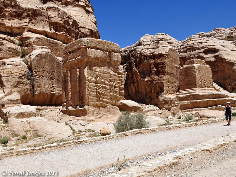
Nabatean Djinn blocks at Petra. Some sources refer to these as god-blocks.Photo by Ferrell Jenkins.

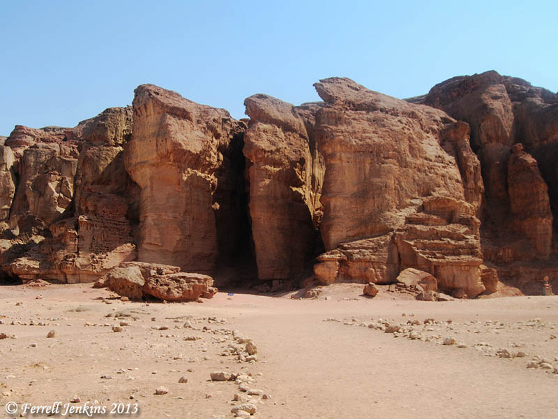
I have noticed erosion in the structures cut from the beautiful sandstone at Petra since my first visit in 1967. Some of this may have been caused by those who fill little bottles with the various colors of sand to sell to the tourists.

Natural erosion is evidence in these structures cut from the beautiful sandstone structures of Petra. Photo by Ferrell Jenkins.

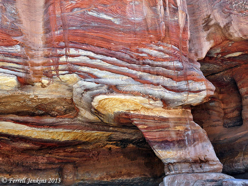
Natural erosion is evidenced in these structures cut from the beautiful sandstone structures of Petra. Photo by Ferrell Jenkins.

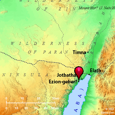
This territory was once inhabited by the Biblical Edomites, but the structures we see today were carved from stone by the Nabateans who inhabited the area from about the fourth century B.C. to the early second century A.D.

One of the most famous Nabatean rulers was Aretas IV (about 9 B.C. to A.D. 40). It was during his reign, which extended at far north as Damascus, when Paul escaped Damascus (2 Corinthians 11:32-33). See here.

HT: Jack Sasson

Solomon’s Seaport at Ezion-geber

The cedar from Lebanon was brought by sea to Joppa for the building of Solomon’s temple (2 Chronicles 2:16). But that port was not adequate to meet Israel’s needs. Scripture informs us that Solomon built a fleet of ships at Ezion-geber.

King Solomon built a fleet of ships at Ezion-geber, which is near Eloth on the shore of the Red Sea, in the land of Edom. And Hiram sent with the fleet his servants, seamen who were familiar with the sea, together with the servants of Solomon. And they went to Ophir and brought from there gold, 420 talents, and they brought it to King Solomon. (1Kings 9:26-28 ESV)

Then Solomon went to Ezion-geber and Eloth on the shore of the sea, in the land of Edom. And Hiram sent to him by the hand of his servants ships and servants familiar with the sea, and they went to Ophir together with the servants of Solomon and brought from there 450 talents of gold and brought it to King Solomon. (2 Chronicles 8:17-18 ESV)

Ezion-geber is said to be near Eloth (Elat, Elath, in some English versions). We pointed out in the previous post that Nelson Glueck thought he had located Ezion-geber at Tell el-Kheleifeh and that it was the same as Eloth. In 1962 Beno Rothenberg demonstrated that the installation at Tell el-Kheleifeh could not have been for copper smelting. In 1965 Glueck wrote an article in which he agreed with Rothenberg. This means that Tell el-Kheleifeh may not be Ezion-geber.

The north end of the Gulf of Eilat.Aqabah. The view is to the east and the city of Aqabah, Jordan. Tell el-Kheleifeh is only a few blocks north of the shore. Photo by Ferrell Jenkins.

The north end of the Gulf of Eilat/Aqabah. The view is to the east and the city of Aqabah, Jordan. Tell el-Kheleifeh is only a short distance north of the shore in Jordan. Photo by Ferrell Jenkins.

Alexander Flinder says the coastline at Tell el-Kheleifeh is a “sandy beach, with shallow water – totally unsuitable for small craft, let alone for a substantial merchant fleet” (“Is This Solomon’s Seaport?” BAR, July/August 1989, p. 38). Flinder has suggested that Ezion-geber may have been on a small island in the Gulf of Eilat/Aqabah called Jezirat Faraun (Pharaoh’s Island). It is located about seven miles south of modern Eilat, but now under Egyptian control. Flinder’s study shows that there has been an artificial harbor at this location in several historical periods and that it was characteristic of other known Phoenician ports. See the complete article for more details and photos.

Pharaoh's Island in the Gulf of Eilat/Aqabah from the west. Photo by Ferrell Jenkins.

Pharaoh’s Island in the Gulf of Eilat/Aqabah from the west. Photo by Ferrell Jenkins.

Meir Lubetski, ABD, says,

Unique were the underwater archaeological findings which established the existence of an artificial enclosed harbor bordering a sizable natural anchorage, with jetties built out into the water to influence currents opposite the island on the shore of the mainland.

I can only point to a suggestion regarding the identity of Ezion-geber with Eloth (Elath). Kenneth A. Kitchen (New Bible Dictionary, 3rd ed., 1996, p. 305). says the two places were,

  • Separate stations during the Israelite wandering (Numbers 33:35-36; Deuteronomy 2:8).
  • Ezion-geber appears to be mentioned alone in the 10th-9th centuries, and is the point from which Solomon sent ships.
  • Jehoshaphat’s planned expedition from Ezion-geber was wrecked (1 King 22:48; 2 Chronicles 20:36-37).
  • King Uzziah of Judah captured Elath/Eloth from Edom and rebuilt it in the 8th century (2 Kings 14:22).
  • Ahaz lost the port to the Edomites (2 Kings 16:6).
View of Pharaoh's Island from the west. The view looks east across the Gulf of Eilat/Aqabah. The land in the distance is Saudi Arabia, the Biblical land of Midian. Photo by Ferrell Jenkins.

View of Pharaoh’s Island from the west. The view looks east across the Gulf of Eilat/Aqabah to Saudi Arabia, the Biblical land of Midian. Photo by Ferrell Jenkins.

The map at BibleAtlas.org shows the places we have discussed in this and the previous post. Notice the location of Ezion-geber is indicating, with a question mark, the location of Pharaoh’s Island.

Map of Ezion-geber, Elath, and Timnah. BibleAtlas.org.

Map of Ezion-geber, Elath, and Timnah. BibleAtlas.org.

Copper production in the time of Solomon

The “promised land” was described to the Israelites as “a land whose stones are iron, and out of whose hills you can dig copper” (Deuteronomy 8:9). Copper was mined in the Arabah of Israel as far back as the 13th-12th century B.C. Copper is still mined at Timna about 25 miles north of Eilat (close to Ezion-geber). Belgian engineers made a survey proving the presence of 100,000 tons of metallic copper. Iron ore has been found in the Negev and in eastern Upper Galilee (Vilnay, The Israel Guide, 17).

The Bible does not say that Solomon had copper mines at Ezion-geber, but the presence of mining facilities dating to the 10th century B.C. indicates that this may have been one of the reasons why the King built a port and had a navy stationed there (1 Kings 9:26-28). Ezion-geber was more than 220 miles from Jerusalem. The copper provided a good medium of exchange for gold, spices, and other items that Israel needed.

These massive pillars at Timna have been associated with Solomon for a long time. Photo by Ferrell Jenkins.

The Pillars of Solomon. These massive pillars at Timna have been associated with Solomon for a long time. Photo by Ferrell Jenkins.

In 1938, Nelson Glueck, reported that he had found a copper-refining plant at Tell el-Kheleifeh, which he identified as Ezion-geber, on the north shore of the Gulf of Aqabah (the Israelis call it the Gulf of Eilat). This site is now within Jordanian territory. Glueck identified the copper-refining plant as King Solomon’s copper mines, and explained that the apertures in the buildings served as flueholes. Through them, he thought, “the strong winds from the north-northwest entered into the furnace rooms of this structure,” which he called a “smelter, to furnish a natural draft to fan the flames.”

It is true that copper smelting was done in the Arabah in the time of Solomon, but Glueck later changed his mind about the building he had formerly identified as the refining plant. In 1962 Beno Rothenberg demonstrated that the installation at Tell el-Kheleifeh could not have been for copper smelting.

Glueck was convinced by the findings of Rothenberg that the apertures in the building “resulted from the decay and or burning of wooden beams laid across the width of the walls for bonding or anchoring purposes.” This does not affect any statement of the Bible, but it does mean that the old argument about the copper refining plant found in the Arabah is no longer valid. Glueck’s identification of Tell el-Kheleifeh with Ezion-geber is no longer accepted. We plan to follow this post with one on Solomon’s seaport.

A recent excavation and study, including archaeometric dating (of Site 30 of the southern Arabah) conducted by Erez Ben-Yosef, et al. has provided a new chronological framework for Iron Age copper production at Timna (Israel). Ben-Yosef says the study,

resulted in a new chronological framework for Iron Age copper production in this region. The main period of copper smelting in the southern Arabah was during the 10th century B.C.E., and the extent of New Kingdom Egyptian control over copper production in Timna was more limited than previously believed. (“A New Chronological Framework for Iron Age Copper Production at Timna (Israel).” BASOR 367 (2012), p. 65.

Egyptians welcome visitors to Timna Park. It is true that Egyptians worked in the area during the 13th-12th centuries B.C., but Ben-Yosef says their control over the copper production “was more limited than previously believed.”

Entrance to the Timna Park. Photo by Ferrell Jenkins.

Egyptians welcome visitors to the Timna Park. Perhaps some Israelites should be added. Photo by Ferrell Jenkins.

Other post having to do with copper may be read here, here, and here.

This paragraph provides documentation for some of the material mentioned above. For more information one may check the following books or articles by Nelson Glueck: “The First Campaign at Tell el-Kheleifeh,” Bulletin of the American Schools of Oriental Research, Oct., 1938; The Other Side of the Jordan, 1940; Rivers in the Desert, 1949; the change was announced in “Ezion-geber,” The Biblical Archaeologist, Sept., 1965.

Is Masada mentioned in the Bible?

N.B. This is post number 1500 since our beginning in 2007.

— ♦ —

The Hebrew word masada is generally translated stronghold or fortress in the English Bible. Gordon Franz (lifeandland.org) says King David visited the site of Masada at least three times.

  1. After sending his parents to Moab (1 Samuel 22:1-5). Take a look at the previous post with the photos and map showing the lisan (tongue) of the Dead Sea. I envision this as the place where David could most easily cross to Moab and then return to the stronghold.
  2. After he spared Saul’s life at Engedi (En Gedi) (1 Samuel 24:22).
  3. When the Philistines were searching for him (2 Samuel 5:17).

This photo gives some idea of the fortress-like quality under consideration. Note the Dead Sea, the Lisan, and the mountains of Moab in the distance.

After a cable-car ride, or by walking the snake path for about an hour one reaches the entrance to the rock fortress of Masada. Photo by Ferrell Jenkins.

After a cable-car ride, or by walking the snake path for about an hour one reaches the entrance to the rock fortress of Masada. Photo by Ferrell Jenkins.

At least four of David’s psalms mention masada.

  1. Psalm 18:2 (fortress). — “The LORD is my rock and my fortress and my deliverer, my God, my rock, in whom I take refuge, my shield, and the horn of my salvation, my stronghold.” (ESV)
  2. Psalm 31:2-3 — “Incline your ear to me; rescue me speedily! Be a rock of refuge for me, a strong fortress to save me! For you are my rock and my fortress; and for your name’s sake you lead me and guide me;”  (ESV)
  3. Psalm 71:1, 3 (fortress). — “In you, O LORD, do I take refuge; let me never be put to shame!  2 In your righteousness deliver me and rescue me; incline your ear to me, and save me!  3 Be to me a rock of refuge, to which I may continually come; you have given the command to save me, for you are my rock and my fortress.” (ESV)
  4. Psalm 144:1-2 (fortress). — “Of David. Blessed be the LORD, my rock, who trains my hands for war, and my fingers for battle;  2 he is my steadfast love and my fortress, my stronghold and my deliverer, my shield and he in whom I take refuge, who subdues peoples under me.”  (ESV)

We are uncertain about authorship of Psalm 91:1-2 (fortress). Beitzel, in The New Moody Atlas of the Bible, places David at Masada (p. 151; map 58).

Psalm 66:11 uses the word masada (translated net, trap or prison).

This photo was made from the top of Masada toward the Dead Sea. Photo by Ferrell Jenkins.

This photo was made from the top of Masada with a view toward the Dead Sea. The walk below leads to the site of Herod’s palace. Photo by Ferrell Jenkins.

Understand that we are not referring to the Masada built by Herod the Great and later used by Jewish zealots during the period of A.D. 70-72. The stronghold had already been there for millennia.

The article by Gordon Franz is brief, but well documented. Read it here.

A sunrise few have seen

Trent and Rebekah are “vagabonding” for forty days in Israel between the close of the Ashkelon excavation and the opening of their fall semester at Jerusalem University College (also known as the American Institute of Holy Land Studies). Last Thursday morning they were at Masada for the sunrise. I didn’t ask if they spent the night there.

This view from Masada to the east at sunrise is one I have not seen. They graciously allowed me to post it here.

Sunrise from Masada. Photo by Trent and Rebekah, Aug. 01, 2013.

Sunrise from Masada. Photo by Trent and Rebekah, Aug. 01, 2013.

There is more to this photo than just the beauty of it. In their photo you see the Lisan (or Tongue) that extends from the east into the Dead Sea. You may also see the canal through which water is pumped to the southern end of the Sea.

The photo below was made near mid-day from Masada.

View east from Masada near mid-day. Photo by Ferrell Jenkins.

View east from Masada near mid-day. Photo by Ferrell Jenkins.

The same photo below has been enhanced further in Photoshop to reveal the details a little better.

View from Masada (enhanced to show features). Photo by Ferrell Jenkins.

View east from Masada (enhanced to show features). Photo by Ferrell Jenkins.

Last month I wrote about “The topography of Kir-hareseth” here. This map shows the valley that goes down from the Transjordan Plateau in a northwesterly direction to the Lisan Peninsula (tongue) of the Dead Sea. Masada is located directly across from that valley. The Lisan now extends completely across the Dead Sea, as the photos above show. Water is pumped to the southern end of the Sea to allow for the chemicals and minerals to be mined.

Map of the southern end of Dead Sea.

Map of the southern end of Dead Sea. Today the Lisan extends completely across the Dead Sea.

Dr. Rasmussen (HolyLandPhotos’Blog) says,

The Dead/Salt Sea can be divided into two unequal sections by a tongue-shaped peninsula that protrudes into it from the eastern shore (= Lisan in Arabic, Lashon in Hebrew). – Zondervan Atlas of the Bible, 49.

Trent and Rebekah continue to post about the places they are visiting in Israel. Take a look at TrentandRebekah.wordpress.com.

The topography of Kir-hareseth

Kir-hareseth figures prominently in a story recorded in 2 Kings 3. After the death of Ahab (853 B.C.), Mesha, king of Moab, rebelled against the king of Israel. Jehoram (or Joram; 852–841 B.C.), the king of Israel, did not want to give up the tribute that Mesha had been paying Israel. Jehoram prepared for war and convinced Jehoshaphat (870/69–848 B.C.), king of Judah, to join him to engage Mesha in war. They  decided to take the long, circuitous wilderness route. They would go south of the Dead Sea and approach Moab from the south through Edom.

In the map below you see that Kir-hareseth (site of Karak or Kerak, Jordan) sits only a few miles from the desert and the ancient King’s Highway. The famous Karak Crusader castle provides a view to the west toward the Dead Sea.

Location of Kir-hareseth, modern Kerak in Jordan.

Location of Kir-hareseth, modern Karak in Jordan.

Notice that a valley runs northeasterly from Kir-hareseth to the Dead Sea. Remember that the Dead Sea would be dry south of the Lisan (tongue) except for water that is pumped from the north. In the photos below we can see how this area looks today.

Kerak castle from the west side of the ridge on which it stands. Photo by Ferrell Jenkins.

Karak castle from the west side of the ridge on which it stands. Photo by Ferrell Jenkins.

When we travel down the valley toward the Dead Sea, we can turn back toward the east to see Karak castle on the far right of the ridge. Click on the photo for a larger view.

View from the valley below Kir-hareseth. The view is to the east. Photo by Ferrell Jenkins.

View to the east from the valley below Kir-hareseth. Photo by Ferrell Jenkins.

In the next photo we turn to look down the valley toward the Dead Sea (to the west).

View toward the west from below the Kerak castle. Photo by Ferrell Jenkins.

View toward the west from below the Karak castle. Photo by Ferrell Jenkins.

After the king of Moab offered his oldest son on the wall of the city, the Israelites departed and returned home.

Then he took his oldest son who was to reign in his place and offered him for a burnt offering on the wall. And there came great wrath against Israel. And they withdrew from him and returned to their own land. (2 Kings 3:27 ESV)

The valley we have shown above would be the most natural route to take back to Israel. Kir-hareseth is almost 3000 feet above sea level; the Dead Sea is about 1300 feet below sea level. Highway 50 follows the valley and dead ends at highway 65 which runs north-south along the east side of the Dead Sea.

Understanding the topography of an event helps a lot.

Karak castle plays a role in the 2005 movie Kingdom of Heaven. I found it fascinating because I had been to many of the Crusader sites mentioned in it.

Following the news in the Bible World

Beginning with the Six Day War (June 5-10, 1967) I have tried to keep alert to the situation in the countries that are often called the Bible lands or the Bible World. This phrase is given to the countries of Iran, Iraq, Turkey, Syria, Lebanon, Jordan, Israel, Egypt, Greece, et al. where the events of the Bible transpired. Over the past 47 years I have traveled in all of these countries, some extensively, except Iran.

The current news coming out of Egypt is not good, and it is sad to see the conditions there. I wish for peace and justice for the people of Egypt, and the other countries mentioned above. I wish it also for those who would like to travel to these ancient lands to better learn the history, both secular and biblical.

A scene on the Nile River in Upper Egypt. Photo by Ferrell Jenkins.

A scene on the Nile River in Upper Egypt. Photo by Ferrell Jenkins.

The photo above was made from the Nile River in Upper Egypt, near the ancient town of Edfu. When I look at it I am reminded of the Genesis account of the seven lean cows and seven plump cows that Joseph saw coming up out of the Nile (Genesis 41).

More about Ephraim

In the previous post we pointed out that Ephraim, where Jesus went a short time before His death (John 11:54), is identified with Taybeh on the edge of the wilderness.

Ephraim is included on the Madaba Map dating to about 560-565 A.D. Below is a photo of a portion of the Madaba Map. The large town with palm trees around it represents Jericho. Below Jericho the land color changes to black. The entry closest to Jericho, but a little to the right, is Ephraim.

According to the website dealing with The Madaba Map, provided by the Studium Biblicum Franciscanum – Jerusalem, the two lines of white lettering read,

Ephron also Ephraia, where went the Lord

Portion of the Madaba Map mentioning Ephron. Photo by Ferrell Jenkins.

Portion of the Madaba Map mentioning Ephron. Photo by Ferrell Jenkins.

Here is a larger cropped portion of the map identifying Ephron. If your Byzantine Greek is up to date, you can make out all of the words.

Closeup of Ephron reference in Madaba Map. Photo by Ferrell Jenkins.

Closeup of the Ephron reference in Madaba Map. Photo by Ferrell Jenkins.

The inscription is located close to the wilderness, but is too far south. Other similar mistakes are made on the map. One such example would be the location of Ebal and Gerizim (See Victor R. Gold. “The Mosaic Map of Madaba.” Biblical Archaeologist, Sept. 1958: 50-71).

Ruins of a Byzantine church remain at Taybeh. There are also Crusader ruins. The Madaba Map from Jordan reflects the traditions of the 6th century A.D. Add this to the biblical evidence we mentioned equating Ephron, Ophrah, and Ephraim, and we have strong evidence that Taybeh marks the site of Ephraim.

Barry Britnell pointed out that Google Maps spell the name of Taybeh as Taibe.

You may read more about the Madaba Map section on Ephron here. Click on Ancient Sources for quotations from Eusebius and Josephus. Also check the Discussion section for more explanation.

William F. Albright suggested, as early as 1924, that Ephraim was to be identified with En Samye (Ein Samiyeh), a few miles northeast of Taybeh. Well, that gives me another place to visit in the future.

Churning to make butter

Churning Butter

Churning Butter

When I was a kid in the rural south, churning was done in a heavy duty ceramic pot. Butter was made by moving the stick (which had a sort of paddle attached) up and down.  I did not live in Colonial times, but the churn we used looked very much like the one shown in the picture to the left. Ours was a bit taller, I think.

The practice of churning to make butter has been around for thousands of years. It is mentioned in the Wisdom Literature of the Bible.

For the churning of milk produces butter, And pressing the nose brings forth blood; So the churning of anger produces strife. (Proverbs 30:33 NAU)

The ESV consistently uses the word pressing, from the Hebrew mits, three times in that verse.

For pressing milk produces curds, pressing the nose produces blood, and pressing anger produces strife. (Proverbs 30:33 ESV)

The NET Bible probably best conveys the meaning of the text by the use of churning, punching, and stirring up.

For as the churning of milk produces butter and as punching the nose produces blood, so stirring up anger produces strife. (Proverbs 30:33 NET)

The photo below shows a pottery churn from Beersheba, now displayed in the Israel Museum. The sign associated with the churn says,

The churn, used for making butter from milk, first appeared in the Chalcolithic Period [6,500–5,500 years ago] and became an important symbol of the time. To speed up the churning process, a rope was tied to the handles, and the churn was rocked back and forth.

Chalcolithic pottery churn from Beersheba. Israel Museum. Photo by Ferrell Jenkins.

Chalcolithic pottery churn from Beersheba. Israel Museum. Photo by Ferrell Jenkins.

During a visit to Petra, Jordan, in 2008, a group of people were portraying the costumes and activity of earlier Bedouin. Many of the customs portrayed are the same as those we read about in the Bible.

In the photo below the man is rocking a churn made from an animal skin.

Bedouin churning in an animal skin at Petra. Photo by Ferrell Jenkins.

Bedouin churning butter in an animal skin at Petra. Photo by Ferrell Jenkins.

Finally, here is a photo that I made at Haran in southeastern Turkey, once the home of Abraham (Genesis 11:31 – 12:4), showing a churn made from an animal skin.

Churn made from animal skin at Haran. Photo by Ferrell Jenkins.

Churn made from animal skin at Haran. Photo by Ferrell Jenkins.

“Rejoice and be glad” you are not in Jerusalem

U.S. President Barack H. Obama plans a visit to Israel, the West Bank, Jordan, beginning Wednesday. Preparations are already under way. Arutz Sheva 7 reports here on the problems already evident.

In addition to the fact that Jerusalem is now one of the most difficult cities to navigate (my opinion based on 47 years of travel experience), the Passover is approaching. Jewish families must make many special preparations.

The President will be staying at the famous King David Hotel. If you planned to visit the Herodian Family Tomb behind the hotel, just forget it for a few days.

Over 5,000 police will be directly involved in providing security for Obama and his entourage, while hundreds of others will be helping out in indirect ways. For example, over 100 officers will be added to the police help line specifically to deal with issues called in by citizens relating to the Obama visit. Police will keep citizens updated on all aspects of the visit by phone and through social media.

Over 1,000 police alone will be deployed around the King David Hotel, where Obama will be staying, and will follow Obama around as he pays visits to people and institutions during his three day visit here.

Here is a photo of the King David Hotel from across the western part of the Hinnom Valley. It was taken either from the Protestant Cemetery, the Campus of Jerusalem University College, or a few meters to the north of that.

King David Hotel from the slope of Mount Zion. Photo by Ferrell Jenkins.

King David Hotel from the slope of Mount Zion. Photo by Ferrell Jenkins.

Take a look at some of the traffic problems.

Already on Sunday, long before Obama arrives, traffic in Jerusalem was extremely choked, as police began setting up barricades, and many Jerusalemites took to the road to finish their Passover shopping while the roads are still open.

Among the roads to be closed sporadically during Obama’s visit will be Road 1, between Ben Gurion Airport and the entrance to Jerusalem, as well as main Jerusalem thoroughfares such as Herzl Boulevard and Derech Hevron [Hebron Road]. Police said they will make every effort to ensure that roads are closed only of absolutely necessary.

Several years ago I was in Jerusalem when President Clinton came to visit. Our hotel was far from the Old City, but policemen were stationed about a block apart. Nations normally enjoy these high level visits, but I am not sure this current one means very much, but it keeps Air Force One running. (O.K., you have a right to your opinion.)

HT: Barry Britnell