Tag Archives: Solomon

Solomon’s Quarries #2

Begin at Damascus Gate and walk east along Sultan Suleiman Street and you will soon come to the entrance to Solomon’s Quarries (also called Zedekiah’s Cave). See the previous post for a photo of the entrance and the history of how this underground quarry came to light in the 19th century.

At that point of the Old City north wall you will see the wall built high above a natural scarp of rock. Mackowski describes the stone here as Turonian limestone. He says,

Beneath these structures are the so-called Solomon’s Quarries, though we do not think that they should be looked for in the subterranean passages below, but in the area (through which the modern Sultan Suleiman Street passes) between this artificially cut rocky spur of Bethesda and its counterpart (opposite it to the north) which forms a part of Gordon’s Calvary and the traditional site of Jeremiah’s Grotto. (Jerusalem City of Jesus, Eerdmans, 1978, p.16).

Portions of the north wall of the Old City of Jerusalem is built on a natural scarp of rock. Photo by Ferrell Jenkins.

Portions of the north wall of the Old City of Jerusalem is built on a natural scarp of rock. Photo by Ferrell Jenkins.

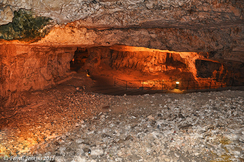
In this post we will follow-up the previous one about the modern discovery of Solomon’s Quarries with some photos. Our first photo shows the corridor leading from the entry south underneath the Old City.

Due to the artificial lighting each photo can look different due to the camera settings, and/or due to the adjustments in Photoshop.

Corridor leading south from the entry of Solomon's Quarries. Photo by Ferrell Jenkins.

Corridor leading south from the entry of Solomon’s Quarries. Photo by Ferrell Jenkins.

The next photo shows a wider area of the quarry, and you can see a fissure in the ceiling. Fissures like this one may account for Barclay’s description here:

Water was everywhere dropping from the lofty ceiling, which had formed numerous small stalactites and stalagmites—some of them very resplendent and beautiful, but too fragile to be collected and preserved. (The City of the Great King, p. 461)

Solomon's Quarries. Notice the fissure in the ceiling. Photo by Ferrell Jenkins.

Solomon’s Quarries. Notice the fissure in the ceiling. Photo by Ferrell Jenkins.

Next we move into the largest area of the quarries. I think it is in this area where the recent TV series Dig built a pool in which a couple of the characters went skinny dipping. If you have been tempted to watch the series to learn about the archaeology of Israel, you might want to think again. Or, you could read the review in The Times of Israel here.

Freemason's Hall in Solomon's Quarries. Photo by Ferrell Jenkins.

Freemason’s Hall in Solomon’s Quarries. Photo by Ferrell Jenkins.

Next we see the largest area of Solomon’s quarries. This large hall is called The Freemason’s Hall. A sign at the entry to the hall reads,

Members of the Freemason’s Society number among the many European tourists and visitors who have come to see the cave after it was rediscovered in the winter of 1854. The Freemasons regard King Solomon as the first biblical Freemason, and since the cave was popularly viewed as the quarry used by King Solomon in the building of the First Temple, the Freemasons have held their traditional ceremonies during the past century in the main chamber of the cave.

I suppose they would not mind if I take exception to the statement that Solomon was “the first biblical Freemason.”

Freemason's Hall in Solomon's Quarries. Photo by Ferrell Jenkins.

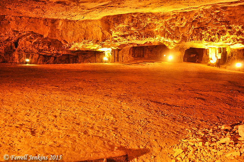
The Freemason’s Hall in Solomon’s Quarries. Photo by Ferrell Jenkins.

Earlier we cited Mackowski who suggested that the quarry used by Solomon was probably where Sultan Suleiman Street is now — between the outcropping of rock we showed above and the traditional Gordon’s Calvary.

Lasor reminds us that there is no archaeological evidence for this being Solomon’s Quarries, but that the tradition is not unreasonable.

A tradition that the stone for the temple was quarried in the area near the modern Damascus Gate, known as Solomon’s Quarries, Royal Quarries, Royal Caves, King Solomon’s Mines, and the cave of Zedekiah, is without archeological support, but the tradition is not unreasonable (cf. 1 K. 6:7). (W. S. Lasor, “Jerusalem.” ISBE (Rev. ed.) Vol. II, p.1008).

Visualizing Isaiah: Trusting in horses and chariots

The prophet Isaiah describes what had happened to the people of Judah and Jerusalem.

Their land is filled with silver and gold, and there is no end to their treasures; their land is filled with horses, and there is no end to their chariots. (Isaiah 2:7 ESV)

The nation had come to depend on instruments of war rather than the LORD God.

Before the entry into the promised land, the LORD said that His people would desire a king. He laid down restrictions for that king. One of the stipulations is stated this way:

Only he must not acquire many horses for himself or cause the people to return to Egypt in order to acquire many horses, since the LORD has said to you, ‘You shall never return that way again.’ (Deuteronomy 17:16 ESV)

Solomon is especially noted for his trade in horses and chariots from Egypt (1 Kings 10:28-29).

Ahab, king of the northern kingdom of Israel, had a powerful army. The Assyrian king Shalmanesser III met Ahab and 11 other kings in the Battle of Qarqar in 853 B.C. The stone monolith from Kurkh records that Ahab provided 2,000 chariots and 10,000 foot soldiers to the confederacy.

Stables have been uncovered during excavations at Megiddo. The town is so clearly associated with horses and chariots that a metal sculpture has been erected at the site.

Metal sculpture of horses and chariot at Megiddo. Photo by Ferrell Jenkins.

Metal sculpture of horses and chariot at Megiddo. Photo by Ferrell Jenkins.

Because Megiddo was located on the main trunk road between Egypt and the empires of the north (Hittites and Syria) and those of the east (Assyria, Babylon, and Persia), we should not find this surprising.

Solomon is said to have built the house of the LORD, his own house, the Millo and the Wall of Jerusalem, and the cities of Hazor, Megiddo, and Gezer (1 Kings 9:15). The same context makes reference to chariot cities built by Solomon:

and all the store cities that Solomon had, and the cities for his chariots, and the cities for his horsemen, and whatever Solomon desired to build in Jerusalem, in Lebanon, and in all the land of his dominion. (1 Kings 9:19 ESV

Isaiah was spot-on.

Solomon’s Seaport at Ezion-geber

The cedar from Lebanon was brought by sea to Joppa for the building of Solomon’s temple (2 Chronicles 2:16). But that port was not adequate to meet Israel’s needs. Scripture informs us that Solomon built a fleet of ships at Ezion-geber.

King Solomon built a fleet of ships at Ezion-geber, which is near Eloth on the shore of the Red Sea, in the land of Edom. And Hiram sent with the fleet his servants, seamen who were familiar with the sea, together with the servants of Solomon. And they went to Ophir and brought from there gold, 420 talents, and they brought it to King Solomon. (1Kings 9:26-28 ESV)

Then Solomon went to Ezion-geber and Eloth on the shore of the sea, in the land of Edom. And Hiram sent to him by the hand of his servants ships and servants familiar with the sea, and they went to Ophir together with the servants of Solomon and brought from there 450 talents of gold and brought it to King Solomon. (2 Chronicles 8:17-18 ESV)

Ezion-geber is said to be near Eloth (Elat, Elath, in some English versions). We pointed out in the previous post that Nelson Glueck thought he had located Ezion-geber at Tell el-Kheleifeh and that it was the same as Eloth. In 1962 Beno Rothenberg demonstrated that the installation at Tell el-Kheleifeh could not have been for copper smelting. In 1965 Glueck wrote an article in which he agreed with Rothenberg. This means that Tell el-Kheleifeh may not be Ezion-geber.

The north end of the Gulf of Eilat.Aqabah. The view is to the east and the city of Aqabah, Jordan. Tell el-Kheleifeh is only a few blocks north of the shore. Photo by Ferrell Jenkins.

The north end of the Gulf of Eilat/Aqabah. The view is to the east and the city of Aqabah, Jordan. Tell el-Kheleifeh is only a short distance north of the shore in Jordan. Photo by Ferrell Jenkins.

Alexander Flinder says the coastline at Tell el-Kheleifeh is a “sandy beach, with shallow water – totally unsuitable for small craft, let alone for a substantial merchant fleet” (“Is This Solomon’s Seaport?” BAR, July/August 1989, p. 38). Flinder has suggested that Ezion-geber may have been on a small island in the Gulf of Eilat/Aqabah called Jezirat Faraun (Pharaoh’s Island). It is located about seven miles south of modern Eilat, but now under Egyptian control. Flinder’s study shows that there has been an artificial harbor at this location in several historical periods and that it was characteristic of other known Phoenician ports. See the complete article for more details and photos.

Pharaoh's Island in the Gulf of Eilat/Aqabah from the west. Photo by Ferrell Jenkins.

Pharaoh’s Island in the Gulf of Eilat/Aqabah from the west. Photo by Ferrell Jenkins.

Meir Lubetski, ABD, says,

Unique were the underwater archaeological findings which established the existence of an artificial enclosed harbor bordering a sizable natural anchorage, with jetties built out into the water to influence currents opposite the island on the shore of the mainland.

I can only point to a suggestion regarding the identity of Ezion-geber with Eloth (Elath). Kenneth A. Kitchen (New Bible Dictionary, 3rd ed., 1996, p. 305). says the two places were,

  • Separate stations during the Israelite wandering (Numbers 33:35-36; Deuteronomy 2:8).
  • Ezion-geber appears to be mentioned alone in the 10th-9th centuries, and is the point from which Solomon sent ships.
  • Jehoshaphat’s planned expedition from Ezion-geber was wrecked (1 King 22:48; 2 Chronicles 20:36-37).
  • King Uzziah of Judah captured Elath/Eloth from Edom and rebuilt it in the 8th century (2 Kings 14:22).
  • Ahaz lost the port to the Edomites (2 Kings 16:6).
View of Pharaoh's Island from the west. The view looks east across the Gulf of Eilat/Aqabah. The land in the distance is Saudi Arabia, the Biblical land of Midian. Photo by Ferrell Jenkins.

View of Pharaoh’s Island from the west. The view looks east across the Gulf of Eilat/Aqabah to Saudi Arabia, the Biblical land of Midian. Photo by Ferrell Jenkins.

The map at BibleAtlas.org shows the places we have discussed in this and the previous post. Notice the location of Ezion-geber is indicating, with a question mark, the location of Pharaoh’s Island.

Map of Ezion-geber, Elath, and Timnah. BibleAtlas.org.

Map of Ezion-geber, Elath, and Timnah. BibleAtlas.org.

Copper production in the time of Solomon

The “promised land” was described to the Israelites as “a land whose stones are iron, and out of whose hills you can dig copper” (Deuteronomy 8:9). Copper was mined in the Arabah of Israel as far back as the 13th-12th century B.C. Copper is still mined at Timna about 25 miles north of Eilat (close to Ezion-geber). Belgian engineers made a survey proving the presence of 100,000 tons of metallic copper. Iron ore has been found in the Negev and in eastern Upper Galilee (Vilnay, The Israel Guide, 17).

The Bible does not say that Solomon had copper mines at Ezion-geber, but the presence of mining facilities dating to the 10th century B.C. indicates that this may have been one of the reasons why the King built a port and had a navy stationed there (1 Kings 9:26-28). Ezion-geber was more than 220 miles from Jerusalem. The copper provided a good medium of exchange for gold, spices, and other items that Israel needed.

These massive pillars at Timna have been associated with Solomon for a long time. Photo by Ferrell Jenkins.

The Pillars of Solomon. These massive pillars at Timna have been associated with Solomon for a long time. Photo by Ferrell Jenkins.

In 1938, Nelson Glueck, reported that he had found a copper-refining plant at Tell el-Kheleifeh, which he identified as Ezion-geber, on the north shore of the Gulf of Aqabah (the Israelis call it the Gulf of Eilat). This site is now within Jordanian territory. Glueck identified the copper-refining plant as King Solomon’s copper mines, and explained that the apertures in the buildings served as flueholes. Through them, he thought, “the strong winds from the north-northwest entered into the furnace rooms of this structure,” which he called a “smelter, to furnish a natural draft to fan the flames.”

It is true that copper smelting was done in the Arabah in the time of Solomon, but Glueck later changed his mind about the building he had formerly identified as the refining plant. In 1962 Beno Rothenberg demonstrated that the installation at Tell el-Kheleifeh could not have been for copper smelting.

Glueck was convinced by the findings of Rothenberg that the apertures in the building “resulted from the decay and or burning of wooden beams laid across the width of the walls for bonding or anchoring purposes.” This does not affect any statement of the Bible, but it does mean that the old argument about the copper refining plant found in the Arabah is no longer valid. Glueck’s identification of Tell el-Kheleifeh with Ezion-geber is no longer accepted. We plan to follow this post with one on Solomon’s seaport.

A recent excavation and study, including archaeometric dating (of Site 30 of the southern Arabah) conducted by Erez Ben-Yosef, et al. has provided a new chronological framework for Iron Age copper production at Timna (Israel). Ben-Yosef says the study,

resulted in a new chronological framework for Iron Age copper production in this region. The main period of copper smelting in the southern Arabah was during the 10th century B.C.E., and the extent of New Kingdom Egyptian control over copper production in Timna was more limited than previously believed. (“A New Chronological Framework for Iron Age Copper Production at Timna (Israel).” BASOR 367 (2012), p. 65.

Egyptians welcome visitors to Timna Park. It is true that Egyptians worked in the area during the 13th-12th centuries B.C., but Ben-Yosef says their control over the copper production “was more limited than previously believed.”

Entrance to the Timna Park. Photo by Ferrell Jenkins.

Egyptians welcome visitors to the Timna Park. Perhaps some Israelites should be added. Photo by Ferrell Jenkins.

Other post having to do with copper may be read here, here, and here.

This paragraph provides documentation for some of the material mentioned above. For more information one may check the following books or articles by Nelson Glueck: “The First Campaign at Tell el-Kheleifeh,” Bulletin of the American Schools of Oriental Research, Oct., 1938; The Other Side of the Jordan, 1940; Rivers in the Desert, 1949; the change was announced in “Ezion-geber,” The Biblical Archaeologist, Sept., 1965.

Seeking the history beneath Solomon’s city at Gezer

Southwestern Baptist Theological Seminary has released information about the most recent season of archaeology at Tel Gezer here.

Aerial view of Tel Gezer toward the coastal plain, SW from the site. Photo by Ferrell Jenkins.

Southwest aerial view of Tel Gezer toward the coastal plain. Photo by Ferrell Jenkins.

This summary of the most recent season was written by Steven Ortiz and Samuel Wolff.

The excavations at Gezer are sponsored by the Tandy Institute of Archaeology at Southwestern Baptist Theological Seminary with several consortium schools. The excavations are directed by Steven Ortiz of the Tandy and Samuel Wolff of the Israel Antiquities Authority.

In this, the sixth season of excavation, one goal was to remove a portion of the city wall built in the Iron IIA period (10th century BCE) in order to investigate a Late Bronze age destruction level (ca. 1400 BCE) that lay below it. To the surprise of the team, in the process of excavating the city wall, an earlier wall system dating to the Iron Age I (1200-1000 BCE) was discovered. This wall was one meter thick with several rooms attached to it. These rooms were filled by a massive destruction, nearly one meter in height,that included Canaanite storage jars, Philistine pottery and other items. A fragment of a Philistine figurine was also found this season. The biblical text record that the king of Gezer organized a Canaanite coalition against Joshua and David had a battle with the Philistines where he chased them “all the way to Gezer.” Perhaps the biblical accounts retain a memory of the importance of Gezer and its close relations to the Philistines during this period.

Beneath this city was an earlier city that was destroyed in a fierce conflagration. This city was functioning during the Egyptian 18th Dynasty’s rule over the southern Levant. Within the destruction debris were several pottery vessels along with a cache of cylinder seals and a large Egyptian scarab with the cartouche of Amenhotep III. This pharaoh was the father of the heretic King Akenaton and grandfather of the famous Tutankhamun (King Tut). This destruction corresponds to other destructions of other cities in the region, a reflection of the internecine warfare that was occurring between the Canaanite cites as reflected in the well-known Tell el-Amarna correspondence.

The archaeology of Solomon has been controversial, fueled by various theories over the dating of the archaeological record. The dating of the Gezer Iron Age Gate is at issue. The Gezer expedition is slowly stripping away layers of public and domestic structures of the 8th and 9th centuries BCE in order to reveal the 10th century city plan adjacent to the City Gate. This summer the tops of the 10th century walls began to poke out, making the archaeologists optimistic that in future seasons more of the Solomonic city will be exposed.

For more information see www.telgezer.com.

Steven Ortiz, professor of archaeology at Southwestern Seminary, is co-director of the archaeological excavations at Tel Gezer, site of one of the famed cities of Solomon located between Jerusalem and Tel Aviv.  Photo by Matt Miller.

Steven Ortiz, professor of archaeology at Southwestern Seminary, is co-director of the archaeological excavations at Tel Gezer, site of one of the famed cities of Solomon located between Jerusalem and Tel Aviv. Photo by Matt Miller.

For earlier posts about Gezer, see the following: aerial photo with a view toward the hill country, boundary stones, and the water system.

HT: Joseph Lauer