Ancient Gadara has been described by a former Jordanian villager who once lived there as a town “without a soul.” The reason for his description is explained by Sunny Fitzgerald in a recent issue of BBC Travel.
In the 1960s, Jordan’s Department of Antiquities declared Gadara an archaeological site; it’s now awaiting consideration for Unesco World Heritage status.
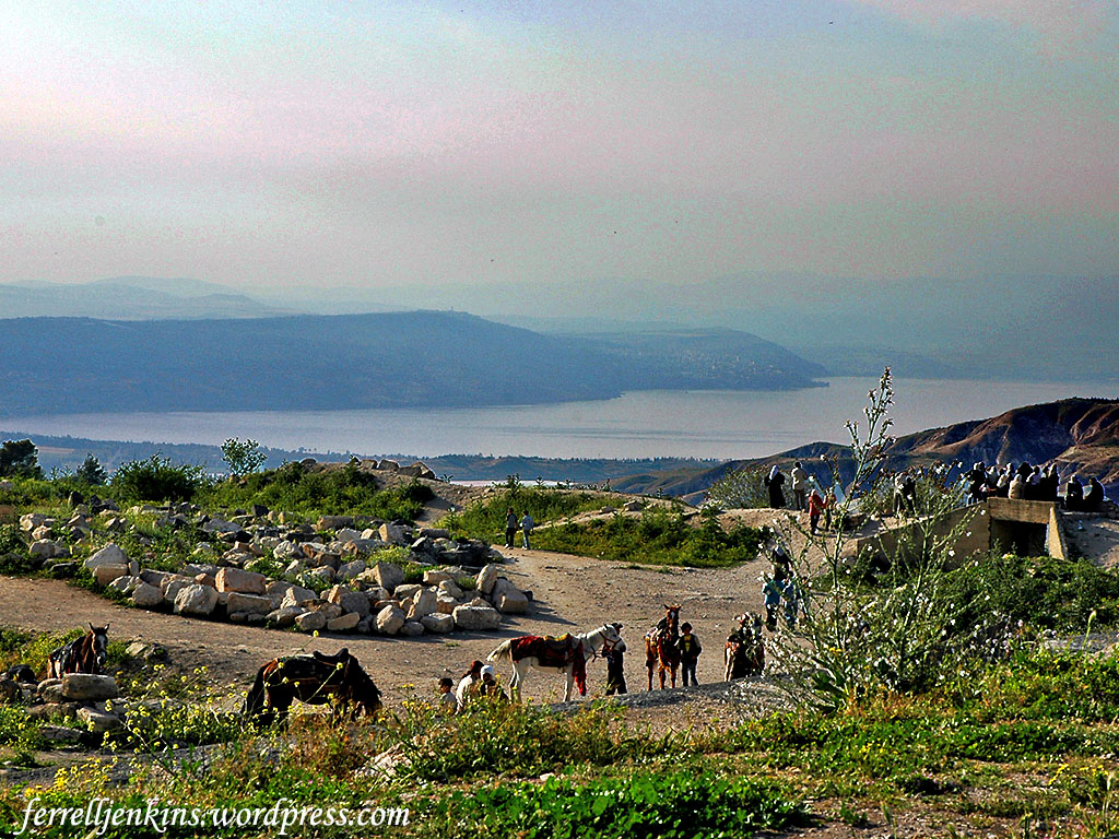
The local citizens were moved from the ancient site, but they still visit it for the beautiful scenes of the Sea of Galilee and the Yarmuk valley below Umm Qais.
View of the Sea of Galilee in the late afternoon from Umm Qais (Gadara). Notice the slight red sky showing through the haze. Photo by Ferrell Jenkins.
Fitzgerald’s illustrated article is a fascinating one that I highly recommend that you read it.
Umm Qais (a common spelling; also Umm Qeis and Um Qays) is the site of Gadara, one of the cities of the Greco-Roman Decapolis. The late Mendel Nun discovered 16 ancient ports around the Sea of Galilee, including one for the city of Gadara. The port is located at Tel Samra on the southeast corner of the Sea of Galilee at the modern Ha-on Holiday Village (Mendel Nun. “Ports of Galilee.” Biblical Archaeology Review 25:04; July/Aug 1999).
From Umm Qais (Gadara) one has a great view of the Sea of Galilee and the Yarmuk River valley. We are told that Jesus visited the region of Decapolis.
Then he returned from the region of Tyre and went through Sidon to the Sea of Galilee, in the region of the Decapolis. (Mark 7:31 ESV)
The Gospel of Matthew informs us about the healing by Jesus of two demon-possessed men in the country of the Gadarenes (Matthew 8:28). Mark puts this event in the country of the Gerasenes (Mark 5:1-20). Luke adds that they “sailed to the country of the Gerasenes, which is opposite Galilee” (Luke 8:26).
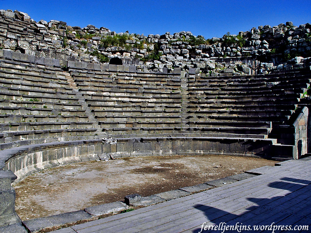
The Roman theater at Umm Qais is made of the local basalt. Photo by Ferrell Jenkins.
The term Decapolis was used to describe a group of ten cities established by the Greeks. Many of them claimed to have been founded by Alexander the Great. The number of cities may have been ten at some time, but the exact number varies from list to list. The cities include Abila [Lysanias was tetrarch of Abilene, Luke 3:1], Gadara [Umm Qeis], Gerasa [Jerash], Hippos, Philadelphia [Amman], Scythopolis [Beth-shan], Pella, et al. These cities are located mostly south of the Sea of Galilee, and all except Scythopolis are east of the Jordan River. Damascus is included in some lists. In the first century A.D. they were part of the Roman province of Syria.
In the Jerusalem area we have evidence of numerous quarries from which stones and pillars (columns) were taken for the Biblical Temple and other buildings. Much of the area now covered by the Church of the Holy Sepulchre, including Golgotha, was once a quarry. In a series of post we discussed the so-called Solomon’s Quarries here and here.
It is also known that an area now referred to as the Russian Compound was a quarry in Biblical times. This is the location of the Russian Orthodox Cathedral of the Holy Trinity, the central police station and the law courts.
The area lies on the northwest corner of the Old City of Jerusalem, and us bounded on the south by Jaffa Road and the Street of the Prophets on the north. It is often referred to as the area of the Assyrian Camp, referencing the occasion when Sennacherib, king of Assyria from 704 to 681 B.C., sent two of his commanders with “a great army from Lachish to Jerusalem” (2 Kings 18:17).
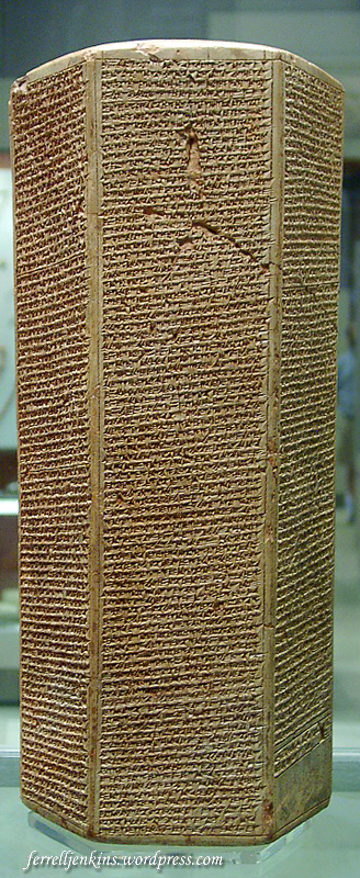
The Taylor Prism reports that Hezekiah was shut up in Jerusalem like a caged bird. Photo by Ferrell Jenkins.
The Taylor Prism, found at Nineveh, and now displayed in the British Museum, claims that Hezekiah did not submit to his y0ke, but was “shut up in Jerusalem” like a caged bird.
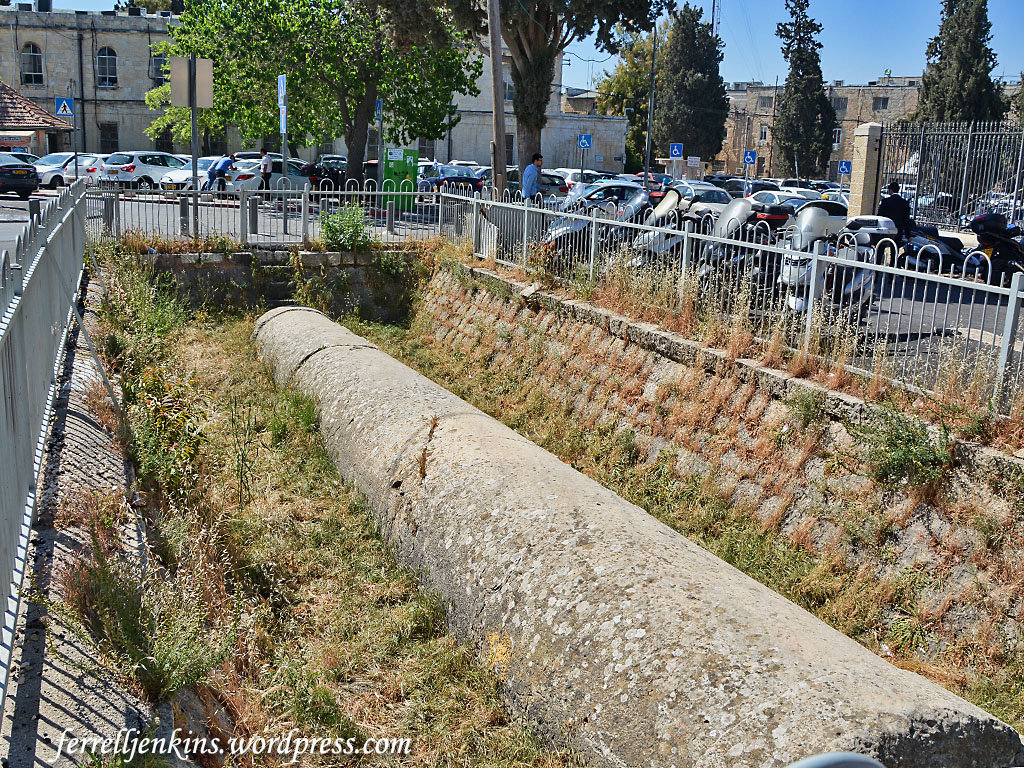
Only one column remains visible in the quarry of the Russian Compound. It is 12.15 meters (almost 40 feet) long and has a mean diameter of about 1.75 meters (5.74 feet). It is greater at the base than at the head.
Pillar left in the quarry at the Russian Compound. Photo by Ferrell Jenkins.
The Blue Guide Jerusalem says,
[The 19th century French scholar] Clermont-Ganneau suggested that the size agreed with that of the columns of the Royal Portico of the Temple of Herod the Great (1 C BC), and may have been one of the engaged columns placed adjacent to the wall.
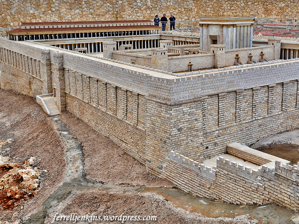
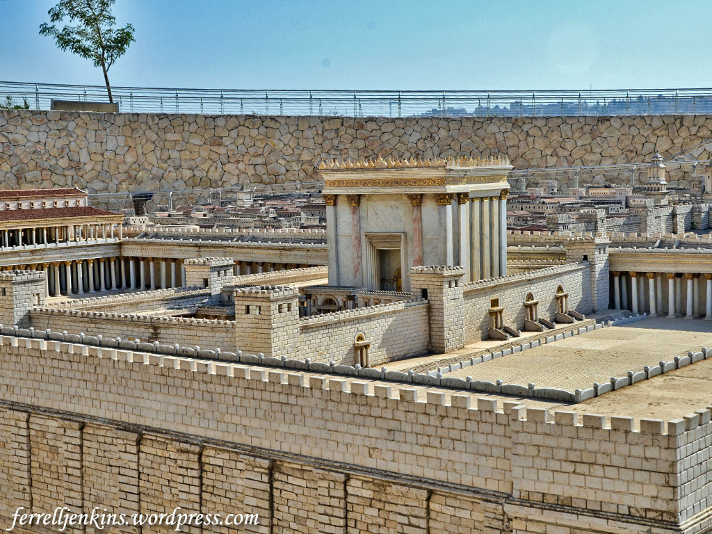
Our photo below shows a model of the Temple precinct built by Herod the Great with work continuing for many years (John 2:20) . The view is from the northeast. The three people viewing the model are standing at the southwest corner of the Temple precinct. The Royal Stoa is to their right on the south side of the model. They appear to be standing at the location of Robinson’s Arch, the stairway that provided entrance to the Royal Stoa.
The Herodian Temple in the Second Temple Model at the Israel Museum. Photo by Ferrell Jenkins.
Though we have here a pillar or column rather than a stone, I think we have a nice reminder of the prophecy of Psalm 118:22.
The stone that the builders rejected has become the cornerstone. (Psalm 118:22 ESV)
Jesus made reference to this text in His teaching (Matthew 21:42; Mark 12:10; Luke 20:17). The Apostle Peter cited the same text and applied it to Jesus.
This Jesus is the stone that was rejected by you, the builders, which has become the cornerstone. (Acts 4:11 ESV).
See also his extended discussion in 1 Peter 2:4-10, and think seriously about the consequences of rejecting the LORD’S chosen stone.
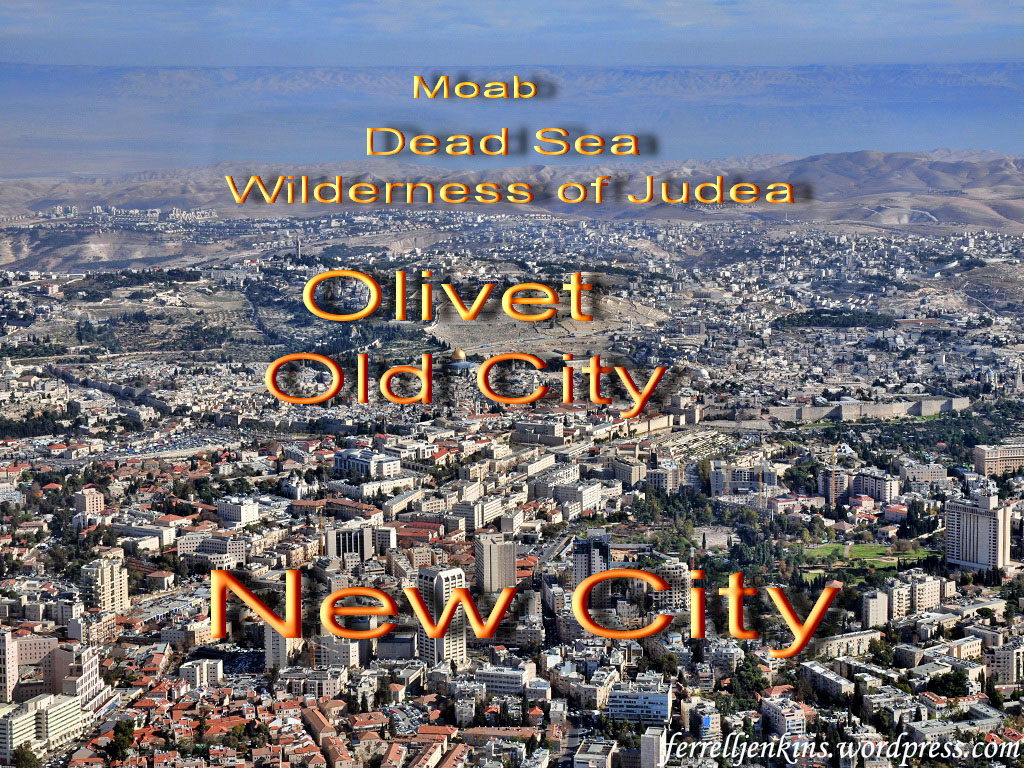
Earlier this week I was browsing through some of my aerial photos of Jerusalem and came across this one that I thought would be informative to good Bible students.
The photo is made while flying over the new (western) city of Jerusalem, some of which is shown in the bottom half of the photo. About mid-way of the photo (from bottom to top) you can see the entire Old (walled) City of Jerusalem. The Dome of the Rock, where the biblical Temple once stood, is almost in the center of the photo (sightly left of center).
The Kidron valley is lost at this angle and the new tombs on the Mount of Olive seem to touch the Old City.
Aerial view of Jerusalem from the west. This photo shows the new (west) city of Jerusalem, the Old City, the Mount of Olives, the wilderness of Judea, the Dead Sea, and the mountains of Moab (Transjordan plateau). Photo by Ferrell Jenkins.
Continuing east you will see a portion of the Wilderness of Judea, then the Dead Sea. At the extreme left of the Dead Sea a portion of the Jordan Valley is visible.
Beyond the Dead Sea the mountains of Moab are visible in the Transjordan Plateau.
The same photo labeled to identify the places discussed.
— Postscript —
Leon Mauldin and I have made numerous personal study trips to the Bible Lands in addition to the tours we have led. We have included flights to photograph these places from the air. I think you will enjoy Leon’s blog. It was a coincident that just as I finished my article showing Jerusalem to Moab, I received Leon’s blog showing the rooftops of the Old City and the Mount of Olives.
Now after Jesus was born in Bethlehem of Judea in the days of Herod the king, behold, wise men from the east came to Jerusalem, saying, “Where is he who has been born king of the Jews? For we saw his star when it rose and have come to worship him.” When Herod the king heard this, he was troubled, and all Jerusalem with him; and assembling all the chief priests and scribes of the people, he inquired of them where the Christ was to be born. They told him, “In Bethlehem of Judea, for so it is written by the prophet: (Matthew 2:1-5 ESV)
Last April I visited Bethlehem hoping to see the refurbished Church of the Nativity, but the work was still in progress. However, I did see something new. In the courtyard of St. Catherine’s church, near the statue of Jerome, there was a very nice nativity display that I wish to share with our readers.
Nativity display in the courtyard of St. Catherine’s church in Bethlehem. Photo by Ferrell Jenkins.
You may recall that Jerome lived in Bethlehem from about 384 A.D. to 420 A.D. He is best known for translating the ancient Hebrew and Greek manuscripts into what would be called the Latin Vulgate. Our earliest (chronologically) English versions were translated from the Latin rather than from the Greek and Hebrew.
In the past couple of weeks there has been an uptick of interest in previous articles I have written about the birth of Jesus, Bethlehem, and Christmas.
We have compiled an Index of articles dealing with these subject here. Perhaps you will find both the articles and the photographs helpful in your study and teaching.
The Nabateans have been described as “one of the most gifted and vigorous peoples in the Near East of Jesus’ time” (Wright, Biblical Archaeology 229). They exacted high tolls from the caravans which passed their way. The greatest king of the Nabateans was Aretas IV (9 B.C. to A.D. 40). His rule extended as far north as Damascus during the last part of his reign; this was at the time Paul escaped from Damascus (2 Corinthians 11:32).
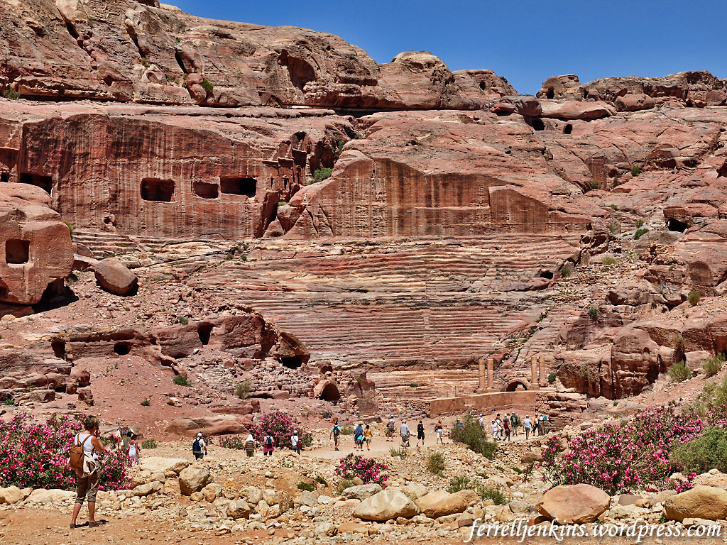
The Nabateans are still remembered for their numerous carvings we see at Petra in Jordan.
The Roman theater at Petra, dating to the first or early second century A.D., is carved almost entirely from solid rock. Click on the photo for a larger image. Photo by Ferrell Jenkins.
The Roman emperor Trajan conquered Petra in A.D. 106 and converted it into the province of Arabia. The Romans continued the rock sculpturing of the Nabataeans but added a theater, a street with colonnades, etc. Some have speculated, on the basis of Galatians 1:17, that Paul spent time at Petra after his conversion to Christ.
Archaeologists working with the Israel Antiquities Authority and Hebrew University have uncovered an Idumean palace or temple in the Lachish region of the Judean Shephelah. I understand the news release to place this discovery south of the Beit Guvrin/Maresha National Park, and east of Lachish, in a military area. This area was allotted to the tribe of Simeon, but by the second century B.C. it had become part of Idumea, the residence of ancient Edomites who were pushed out of the area of Edom (the location of Petra in Jordan) by the Nabateans.
Herod the Great was an Idumean. Some have suggested Maresha as his hometown. He ruled over the Jews from 47 to 4 B.C., and his dynasty continued throughout most of the first century A.D. Herod was known for his fabulous building program that included the temple, the temple platform and the surrounding wall (John 2:20). He was a cruel ruler who sought to destroy the infant Jesus (Matthew 2:16).
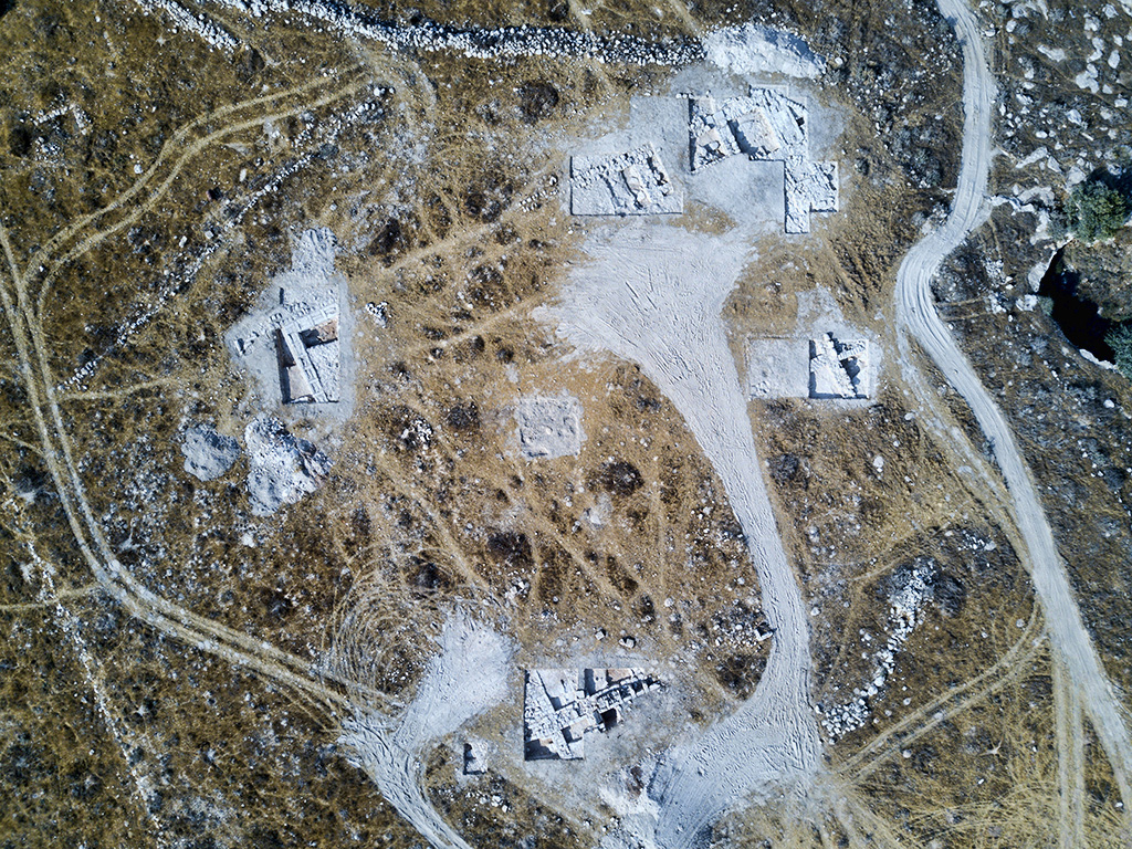
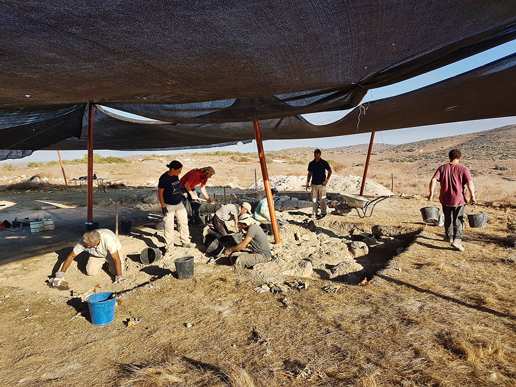
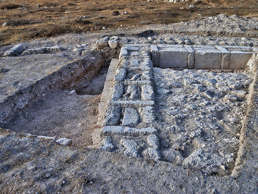
The drone photo below shows portions of the large structure recently discovered.
Area of the large structure, possibly a temple or palace, uncovered in the dig – aerial photograph (photo: Dane Christensen)
The scholars working on the project say this is a 2200-year-old structure that was “apparently dismantled intentionally, perhaps during the Hasmonean conquests of the region.”
The release continues,
— “ —
An impressive 2200-year-old (Hellenistic period) structure, possibly an Idumean palace or temple, was uncovered during Sukkot in archaeological excavations at the site of Horvat ‘Amuda, situated at the heart of a military training area in the Lachish region.
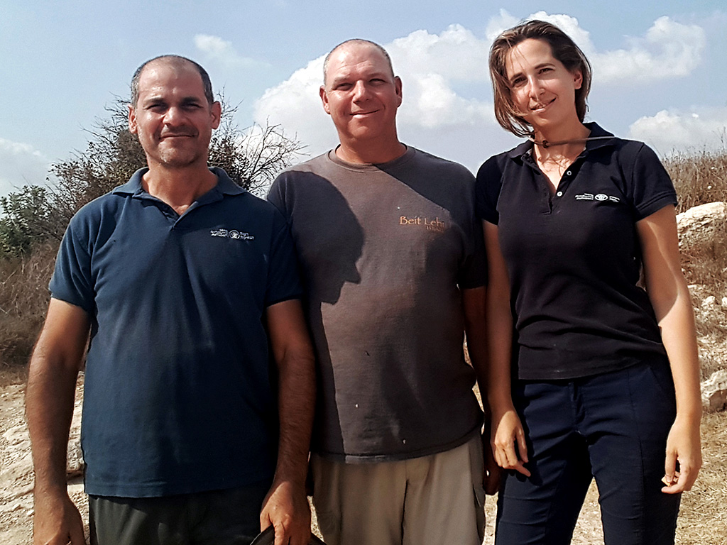
The excavation directors (from right to left): Dr. Oren Gutfeld, Michal Haber, and Pablo Betzer (photo: Israel Antiquities Authority)
According to the excavation directors, Dr. Oren Gutfeld of the Hebrew University, and Pablo Betzer and Michal Haber of the Israel Antiquities Authority: “If this was indeed an Idumean palace or temple, it is a rare and exciting find – similar structures in this country can be counted on the fingers of one hand. It seems that the building was intentionally dismantled, possibly during the Hasmonean conquest of the region.”
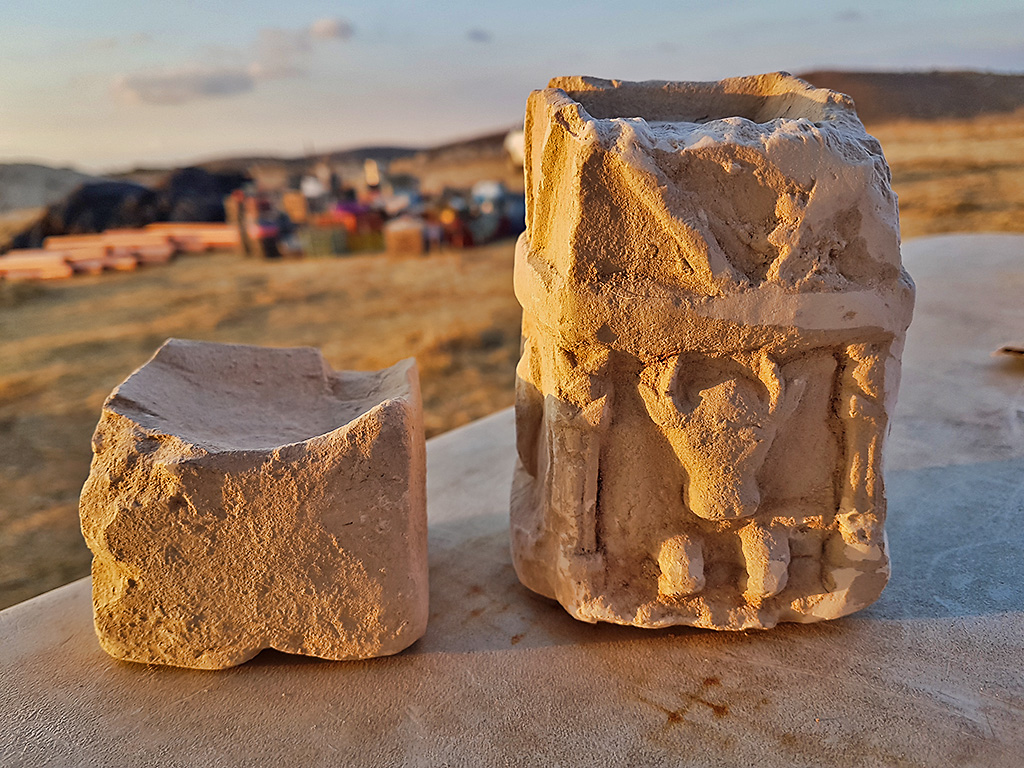
Two cultic incense altars found in one of the rooms of the structure (photo: Michal Haber, Israel Antiquities Authority). These altars are small enough to be held in one’s hand.
Two stone incense altars were discovered in one of the rooms. One of them, bearing the carved image of a bull, is depicted as standing in what is apparently the façade of a temple adorned with magnificent columns. According to the archaeologists, the altar is “a unique and rare find in terms of its decoration.” The bull, they say, “may have symbolized a deity worshipped by the Idumeans.” In addition to the incense altar, delicate pottery vessels were also uncovered, including painted bowls, juglets and oil lamps.
Also found at the site are numerous underground spaces, used as quarries or to house ritual baths (miqvaot), oil presses and dovecotes. Hiding tunnels from the time of the Jewish revolts against the Romans were also discovered; one of these contained an intact cooking pot from the time of the Bar Kokhba Revolt (132–135 CE).
Uncovering the structure (photo: Michal Haber, Israel Antiquities Authority)
The new discovery came to light with the help of camera-equipped drones – technology that has become part of the archaeologists’ tool box in recent years. As part of an extensive archaeological research project of the area between Bet Guvrin and Maresha in the north and Moshav Amatzia in the south, the drone cameras photographed the archaeological remains from high above, subsequently revealing hints of the structure now under excavation. Calling the discovery a research breakthrough, the archaeologists say: “This technology helped us choose where to focus our excavation probes, and, indeed, it very quickly emerged that this was in fact a unique discovery. We hope that our continued excavation of the site in the spring will uncover more of the story told here.”
Remains of the structure indicate that it was intentionally dismantled, possibly by the Hasmoneans (photo: Dane Christensen)
The excavation at Horvat ‘Amuda, which was funded by the Beit Lehi Foundation and the Israel Antiquities Authority, was carried out with the participation of archaeology students from the Hebrew University, Bar-Ilan University, as well as a group of volunteers from the United States.
During the Hellenistic period Horvat ‘Amuda was apparently one of the agricultural satellite settlements of Maresha, which had by now become the Idumean district capital (today it is part of Bet Guvrin-Maresha National Park). Prior to that, in the fifth century BCE (the Persian period), the Idumeans – a Semitic people originating in southern Jordan – settled in the Judean Shephelah (foothills). After the area was conquered by the Hasmoneans in 112 BCE, the Idumeans converted and subsequently blended into the Judean population.
1 Make a joyful noise to the LORD, all the earth!
2 Serve the LORD with gladness! Come into his presence with singing! 3 Know that the LORD, he is God! It is he who made us, and we are his; we are his people, and the sheep of his pasture. 4 Enter his gates with thanksgiving, and his courts with praise! Give thanks to him; bless his name! 5 For the LORD is good; his steadfast love endures forever, and his faithfulness to all generations. (Psalm 100 ESV)
The psalmist reminds his readers why they should praise the LORD. It is because He is God, the one who made them, and the one to whom they belong.
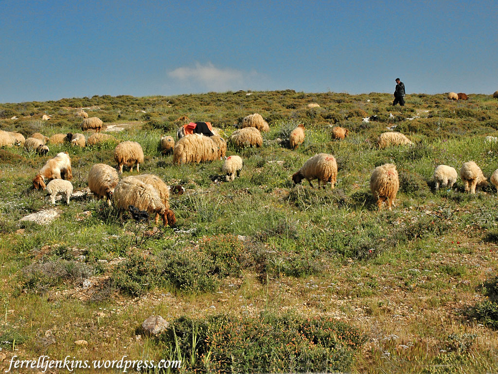
“We are his people, and the sheep of his pasture.” Perhaps a few photos will help us visualize this Psalm.
A shepherd with his sheep near Heshbon in Jordan. Photo by Ferrell Jenkins.
The ancient Israelites were urged to “enter his gates with thanksgiving. Give thanks to him; bless his name!”
This photo of the second temple model at the Israel Museum in Jerusalem shows the south side of the temple mount.. We see steps and gates that led to the temple. Photo by Ferrell Jenkins.
Enter “his courts with praise!”
In this photo of the temple model we see various courts that were part of the temple precinct. Photo by Ferrell Jenkins.
“For the LORD is good; his steadfast love endures forever, and his faithfulness to all generations.”
Hurriyet Daily News recently reported here on plans to reconstruct the ancient stadium in ancient Laodicea. Laodicea is known to Bible students from the book of Revelation (1:11; 3:14-22), and from Paul’s epistle to the Colossians.
For I bear him [Epaphras] witness that he has worked hard for you and for those in Laodicea and in Hierapolis. Luke the beloved physician greets you, as does Demas. Give my greetings to the brothers at Laodicea, and to Nympha and the church in her house. And when this letter has been read among you, have it also read in the church of the Laodiceans; and see that you also read the letter from Laodicea. (Colossians 4:13-16 ESV)
Laodicea is located about 100 miles east of Ephesus, five miles from the modern Turkish town of Denizli, and near the popular resort of Pamukkale.
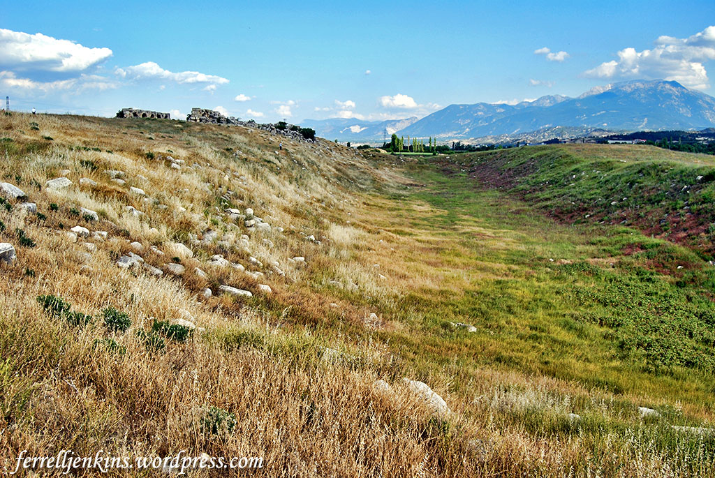
The stadium at Laodicea before the recent efforts to uncover the stadium and restore it. A portion of the nymphaeum is visible on the hill on the left side of the photo. Photo by Ferrell Jenkins.
When I first began traveling to visit the sites of the Seven Churches of the book of Revelation, all we could see at Laodicea was the form of the stadium and ruins of a nymphaeum (a fountain house). If we walked through across the mound to the north we could see the location of two theaters. That was about it.
In recent years tourists have seen many new excavations and reconstructions on the north side of the tell, but few walked through the weeds to get to the stadium.
Originally the stadium was an enclosed structure used for gladiatorial games. An inscription tells that a wealthy family dedicated it to Emperor Vespasian (A.D. 69-79) and Emperor Titus (A.D. 79-81). It is said to be the biggest stadium in Anatolia.
Vespasian and Titus are known for their war with the Jews beginning in A.D. 66, and the destruction of Jerusalem in A.D. 70.
Here is the article from the Hurriyet Daily News for those who wish to read further.
— “ —
Works have been initiated this summer to unearth a stadium in the ancient city of Laodicea, a property on UNESCO’s tentative list for World Heritage Sites. The stadium was a venue for sports competitions and gladiator fights in ancient times and is located in the western province of Denizli.
Excavations and restorations have been ongoing in the ancient city for 13 years under the leadership of Professor Celal Şimşek of the Pamukkale University (PAU) Archaeology Department. Some 4,000 artifacts have been uncovered so far.
The artifacts include figures, sculptures, agricultural tools, and household products and have been under protection. The Holy Agora, which is home to one of the seven holy churches mentioned in the Bible but which collapsed in an earthquake along with its columns in 494 A.D., has been restored and revived.
A project has also been initiated to unearth the Laodicea Stadium, located on Stadium Street in the ancient city and known as the largest stadium in Anatolia in the era.
The project has been approved by the Cultural and Natural Heritage Preservation Board and gets supported by the Merkezefendi Municipality. When it is finished, the stadium will be revived after 1,494 years.
Speaking to Anadolu Agency, Professor Şimşek said this year’s excavation and restoration works have still been continuing in the ancient city, focusing on the project made for the revival of Stadium Street.
“The recovery of the ruined columns continues. They will be revived with their arches within three months. The street will regain life after 1,500 years,” Şimşek said, adding that the street where the excavations are continuing is very important.
He said the Laodecia Stadium was the biggest one in Anatolia.
“It is a gigantic structure that is 285-meters high and 70-meters wide. Right next to it is a bath complex. It is one of the biggest bathes in Anatolia. There is an agora and an assembly building next to it. This place was a field of both sports and administration and people came together. From this aspect, the street has importance too,” said Şimşek.
Arena of gladiators
Şimşek said many competitions were held in the Laodicea Stadium in ancient times and the names of five-time winners of the competitions were written on inscriptions.
“At the same time, this stadium is very important for gladiator fights. The competition was held not only for this city but also the other cities in the Lycus lowlands. All Olympic-size games, local or big sports competitions, and gladiator fights have been held in this stadium,” he said.
A sub-headline in The Times of Israelhere about tell the whole story.
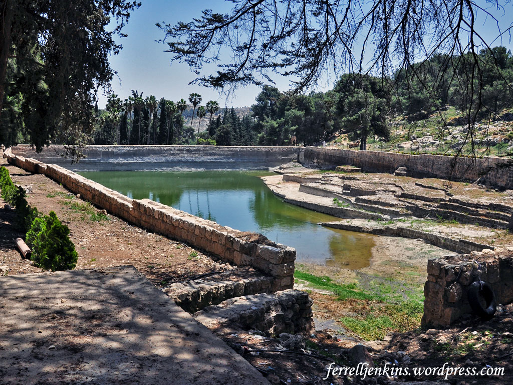
US Consulate funds $750,000 restoration of 2,000-year-old Solomon’s Pools near Bethlehem with hopes of making it a tourist site.
These pools have nothing to do with Solomon, but much to do with Jerusalem’s water supply in New Testament times. I recommend you read my earlier post about this here. I am re-posting some photos of the three pools that I made in 2014.
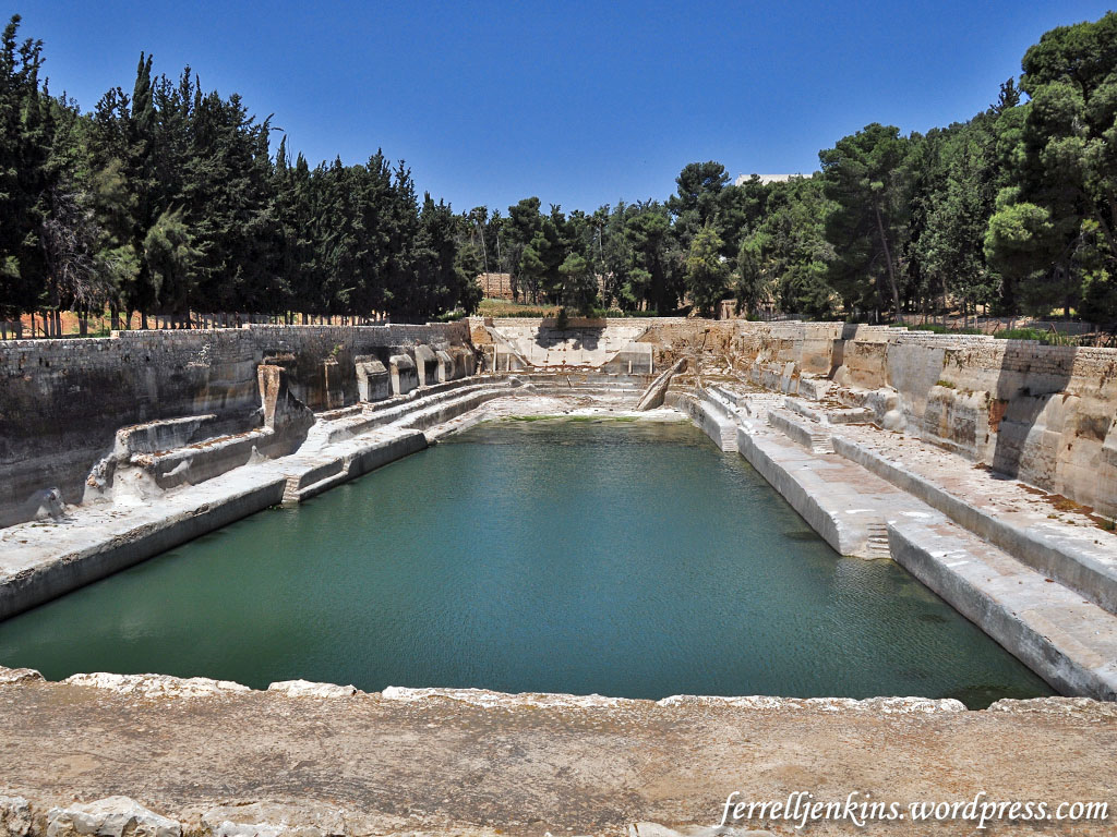
The western pool. View to east. Photo by Ferrell Jenkins.
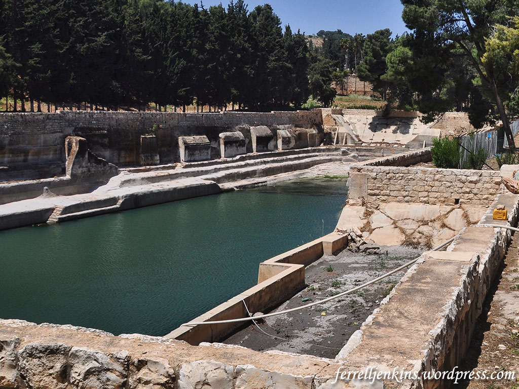
The middle pool is shown here with a view to the northwest. You can see the higher hills in the break between the trees.
The middle pool with a view to the northwest. Photo by Ferrell Jenkins.
The third pool (easternmost) is shown below with a view toward the west.
The third pool (eastern) is shown with a view toward the west. Photo by Ferrell Jenkins.
In the previous article I have several links to more detailed information about these pools and the aqueduct system that carried the water to Jerusalem.
In the earliest days of my tours we were able to visit Solomon’s Pools as we traveled between Bethlehem and Hebron. In recent years it has been more difficult to visit the pools, and we have pointed out before that they are in need of restoration.
Looking forward to the completion of this project that I am helping pay for (if you get my drift).
“New Stone Courses Discovered in the Western Wall Tunnels Reaching the Depths of the Western Wall; Ancient Theater Discovered as Well.”
That’s the way the Israel Antiquities Authority press release this morning begins. Teasers had caused us to believe that something big was coming. Now we have more details that can be shared.
— “ —
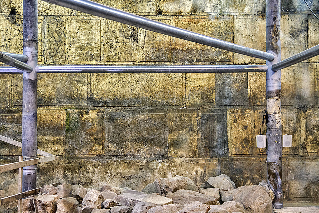
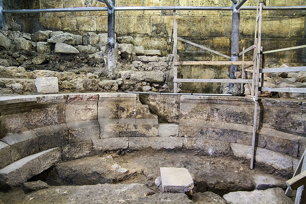
Excavations conducted by the Israel Antiquities Authority, with the participation of volunteers, have uncovered large portions of courses of the Western Wall that have been hidden for 1,700 years. An ancient Roman theater-like structure was exposed for the first time.…
Eight stone courses of the Western Wall that had been buried under an 8-meter layer of earth were recently uncovered in excavations conducted by the Israel Antiquities Authority in the Western Wall Tunnels in Jerusalem. These stone courses, completely preserved, are built of massive stones and are outstanding in the quality of their construction.
Eight courses of the Western Wall were discovered in the excavation. Photograph: Yaniv Berman, courtesy of the Israel Antiquities Authority.
Furthermore, after the removal of this layer of soil, the archaeologists were surprised to discover that it covered the remnants of an extraordinary theater-like structure from the Roman period confirming historical writings that describe a theater near the Temple Mount. These exciting findings will be presented to the public during a conference titled New Studies in the Archaeology of Jerusalem and its Environs, which will take place at the Hebrew University. This year’s conference will mark 50 years of archaeology since the unification of the city.
Israel Antiquities Authority excavation showing the theater-like structure. Photograph: Yaniv Berman, courtesy of the Israel Antiquities Authority.
At a press conference this morning (Monday) beneath Wilson’s Arch in the Western Wall Tunnels, the stone courses and the amazing remnants of the theater were presented. Apparently, a great deal was invested in the construction of the theater which contained approximately 200 seats. The press conference was conducted with the participation of the Western Wall rabbi, Rabbi Shmuel Rabinowitz, Israel Antiquities Authority director, Israel Hasson, Western Wall Heritage Foundation director, Mr. Mordechai (Suli) Eliav, Israel Antiquities Authority district archaeologist Dr. Yuval Baruch, and the excavation directors.
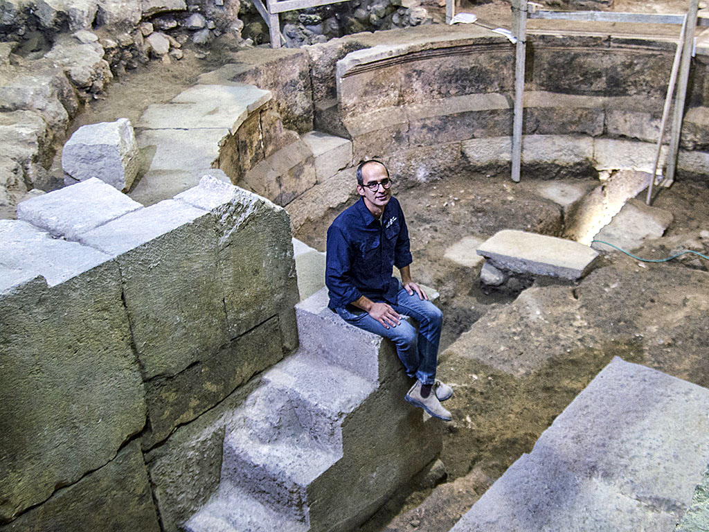
Dr Joe Uziel of the Israel Antiquities Authority, sitting on the steps of the theater structure. Photograph: Yaniv Berman, courtesy of the Israel Antiquities Authority.
From the very beginning of archaeological research in Jerusalem over 150 years ago, scholars have been seeking the public buildings mentioned in the historical sources. Particularly prominent among them, theaters or theater-like structures are mentioned. These descriptions are found in written sources from the Second Temple period (such as Josephus Flavius), and in sources from the period following the destruction of the Second Temple, when Jerusalem became the Roman colony of Aelia Capitolina. Many theories were advanced as to the location of these complexes, but they were without archaeological foundation. That is, until this latest discovery.
Wilson’s Arch is in fact the only intact, visible structure remaining from the Temple Mount compound of the Second Temple period. The arch, built of enormous stones, is the last of a series of such arches that once constituted a gigantic bridge leading to the Temple Mount from the west.
The arch stands high above the foundations of the Western Wall, and it served, among other purposes, as a passageway for people entering the Temple Mount compound and the Temple. A huge aqueduct also passed over the arch.
According to site excavators Dr. Joe Uziel, Tehillah Lieberman and Dr. Avi Solomon: “From a research perspective, this is a sensational find. The discovery was a real surprise. When we started excavating, our goal was to date Wilson’s Arch. We did not imagine that a window would open for us onto the mystery of Jerusalem’s lost theater. Like much of archaeological research, the expectation is that a certain thing will be found, but at the end of the process other findings, surprising and thought-provoking, are unearthed. There is no doubt that the exposure of the courses of the Western Wall and the components of Wilson’s Arch are thrilling discoveries that contribute to our understanding of Jerusalem. But the discovery of the theater-like structure is the real drama.”
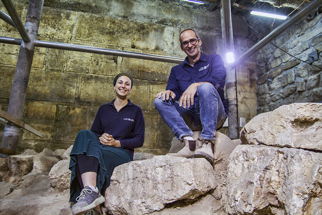
Israel Antiquities Authority excavation directors Dr. Joe Uziel and Tehillah Lieberman at the excavation site. Photograph: Yaniv Berman, courtesy of the Israel Antiquities Authority.
The excavators note: “This is a relatively small structure compared to known Roman theaters (such as at Caesarea, Bet She’an and Bet Guvrin). This fact, in addition to its location under a roofed space – in this case under Wilson’s Arch – leads us to suggest that this is a theater-like structure of the type known in the Roman world as an odeon. In most cases, such structures were used for acoustic performances. Alternatively, this may have been a structure known as a bouleuterion – the building where the city council met, in this case the council of the roman colony of Aelia Capitolina – Roman Jerusalem.”
Interestingly, the archaeologists believe the theater was never used. A number of findings at the site indicate this – among them a staircase that was never completely hewn. It is clear that great effort was invested in the building’s construction but oddly, it was abandoned before it was put to use. The reasons for this are unknown, but they may have been connected to a significant historical event, perhaps the Bar Kokhba Revolt; construction of the building may have been started, but abandoned when the revolt broke out. Additional evidence of unfinished buildings from this period has been uncovered in the past in the excavations of the Eastern Cardo in the Western Wall Plaza.
Numerous findings have been unearthed in the excavations beneath Wilson’s Arch, some of which are unique, including pottery vessels, coins, architectural and architectural elements, and more. Advanced research methods from various fields were employed to uncover remains invisible to the naked eye, but only viewable through a microscope. This enables conclusions to be drawn at a level of precision that would have been impossible in the past, transforming the study of the findings at Wilson’s Arch into pioneering, cutting-edge micro-archaeological research.
“ — ”
The major Israeli papers have covered this announcement, sometimes with their own photos, and I expect that other news outlets will do the same. Here are links to The Times of Israel, Haaretz, and The Jerusalem Post articles. Todd Bolen has summarized the information here, and Luke Chandler has included many other photos showing the Western Wall Plaza here.
This short video (less than 4 minutes) will give you a good concept of the newly excavated area.


You must be logged in to post a comment.