Category Archives: Bible Places

Tomb complex discovered in Tiberias

Many interesting discoveries are made by construction workers who are preparing to build a new structure, built a new road, or install new water, sewer or gas lines. It happened this month in Tiberias. Here is a portion of the report from the Israel Antiquities Authority.

— “ —

A fine and complex burial cave dating from the Roman period (c. 2000 years ago) came to light a couple of days ago in Tiberias. The cave was discovered in the course of development works carried out by the Tiberias Municipality for a new neighborhood in the northern part of the town. The contractor immediately informed the Israel Antiquities Authority when a mechanical digger exposed the cave entrance, and an antiquities inspector came to the site.

The tomb was exposed accidentally during preparation for construction of a housing project. Photo: Miki Peleg, IAA.

The tomb was exposed accidentally during preparation for construction of a housing project. Photo: Miki Peleg, IAA.

The rock-hewn cave comprised an entrance hall decorated with colored plaster, a central room with several burial niches, decorated ceramic and stone ossuaries, and a small inner chamber. Carved stone doors stood at the entrances into the rooms. In one of the chambers Greek inscriptions were engraved with the names of the interred. These inscriptions will be studied by specialists. The cave was probably robbed in antiquity.

According to Yair Amitsur, Antiquities Inspector of Tiberias and Eastern Lower Galilee in the Israel Antiquities Authority, “the cave must have served as a burial complex for a family who lived in the town of Tiberias or in one of the adjacent villages”.

This photo provides a wonderful view into the Roman period tomb with burial niches (kokim) and ossuaries. Photo: Miki Peleg, Israel Antiquities Authority.

This photo provides a wonderful view into the Roman period tomb with burial niches (kokhim) and ossuaries. Photo: Miki Peleg, Israel Antiquities Authority.

Two thousand years ago, in 18 CE, Herod Antipas, the son of Herod the Great, and Governor of the Galilee, established the city of Tiberias and named it in honor of the Roman Emperor Tiberius. Over the centuries, Tiberias served as the capital of the Galilee, and was one of the largest cities in the country. The city extended from south of Hamei Tiberias, the hot springs, to the center of the modern town. In the Roman and Byzantine periods, several smaller villages grew up on the outskirts of the city, including Bet Maon, the home of Resh Lakish, Kofra, Beer Meziga and others. The cave must have been owned by a family from Tiberias, or from one of the surrounding villages, who chose to be interred north of Tiberias, overlooking the Lake of Galilee.

According to Amitsur, “The burial cave is a fascinating discovery since it is an almost unique find in this area. The high-quality rock-hewing, the complexity of the cave, the decorations, and the Greek inscriptions point to the cave belonging to a wealthy family, who lived in the area in the Roman period.”

The cave was blocked up in order to protect it, and it will be researched by experts from the Israel Antiquities Authority.

— ” —

The kokhim-type tombs such as this were typically in use by Jews from the end of the second century B.C. to the fall of Jerusalem in A.D. 70 (McRay, Archaeology and the New Testament, citing V. Tzaferis on p. 204). There may be more recent evidence that would change this understanding, especially in Galilee.

HT: Joseph Lauer

Who is this bearded man from Abel Beth Maacah?

This small head was found at Abel Beth Maacah (also Abel-beth-Maacah, and spelled as one word) during the 2017 archaeological excavations. Announcement was made recently after the artifact was put on display in the Israel Museum.

Faience head of a king discovered at Abel Beth Maacah in northern Israel. Photo released by Azusa Pacific University.

Glazed ceramic head of a king discovered at Abel Beth Maacah in northern Israel. Photo released by Azusa Pacific University.

According to Robert Mullins, Ph.D., lead archaeologist at Abel Beth Maacah and chair and professor in Azusa Pacific’s Department of Biblical and Religious Studies, the head measures 2.2 x 2 inches and has carefully executed features, including glossy black tresses combed back from a headband painted in yellow and black and a manicured beard. His almond-shaped eyes and pupils are lined in black and the pursed lips give him a look that is part pensive, part stern. The glazed surface is tinted light green due to the addition of copper to the quartz paste. Its elegant style indicates that the man was a distinguished personage, probably a king. By all appearances, the head appears to have broken off from the body of a figurine that stood 8-10 inches high.

“Despite the head’s small and innocuous appearance, it provides us with a unique opportunity to gaze into the eyes of a famous person from the past; a past enshrined in the Book of Ages,” said Mullins. “Given that the head was found in a city that sat on the border of three different ancient kingdoms, we do not know whether it depicts the likes of King Ahab of Israel, King Hazael of Aram-Damascus, or King Ethbaal of Tyre, rulers known from the Bible and other sources. The head represents a royal enigma.”

The News Release continues,

Details about the figurine head and its discovery were recently presented to the Israeli archaeological community at the 44th Annual Archaeological Congress at Ben Gurion University of the Negev by Dr. Naama Yahalom-Mack of the Hebrew University of Jerusalem. A more detailed article about the head and the current excavations at Abel Beth Maacah will appear in the June issue of the professional journal, Near Eastern Archaeology. The dig is licensed by the Israel Antiquities Authority and the Israel Nature and Parks Authority.

This photo shows the north end of Abel Beth Maacah with Mount Hermon in the distance across the Beka Valley. Photo by Ferrell Jenkins.

This photo shows the northern end of Abel Beth Maacah with Mount Hermon in the distance across the Beka Valley. Photo by Ferrell Jenkins.

The biblical references to Abel Beth Maacah include the following episodes.

No sooner had King David put down the rebellion of his son Abaslom when a Benjamite by the name of Sheba led a rebellion against him. The men of Israel rebelled against David and followed Sheba, but the men of Judah remained loyal to the king.

Realizing that Sheba was a greater threat than Absalom had been, David called on Abishai to take servants (warriors) and capture Sheba. Joab’s men went out from Jerusalem to capture Sheba. This pursuit took Joab’s men all the way to the north of the Israelite territory, to a town named Abel-Beth-Maacah. Some English versions use Abel Beth Maacah, or a similar variant. In modern Israel this archaeological mound is almost on the border with Lebanon between Kiryat Shmona and Metulla.

The wise woman reasons with Joab. She tells him that this town formerly was a place where people would ask for advice to end a dispute. She said,

 I am one of those who are peaceable and faithful in Israel. You seek to destroy a city that is a mother in Israel. Why will you swallow up the heritage of the LORD?” (2 Samuel 20:19 ESV)

Joab agreed that he would not destroy the city if she would hand over Sheba. She agreed to throw the head of Sheba over the wall. She did what she promised and the destruction was averted. Joab went back to the king in Jerusalem.

Abel-beth-Maacah is mentioned in at least two other passages.

  1. The city was conquered by Ben-hadad, king of Aram [Syria] (1 Kings 15:20).
  2. The city was captured by Tiglath-pileser, king of Assyria, in the days of Pekah of Israel.

A nice photo of the little head on display in the Israel Museum is included with an article by Ilan Ben Zion in The Times of Israel here.

HT: Joseph Lauer

Shiloh, “where the Lord’s tabernacle stands”

Joshua 22:19 describes Shiloh as the place “where the LORD’S tabernacle stands.” During the midst of the allocation of the land to the various tribes of Israel, all of them gathered at Shiloh (Shilo) and set up the tent of meeting or tabernacle (Hebrew mishkan) (Joshua 18:1), which is also called the house of God in Joshua 18:31. Here they made the final division of the land (Joshua 18:8-10).

Then the whole congregation of the people of Israel assembled at Shiloh and set up the tent of meeting there. The land lay subdued before them. (Joshua 18:1 ESV)

The area where the tabernacle is thought to have stood on the north side of the tel as it looked in 2013, and about the same when I saw it earlier this year,  is shown in our first photo. Other scholars place the tabernacle on the summit of the tel, and some on the south end of the tel. Dr. Scott Stripling, the current excavator, suggests that it was first on the summit and later relocated to either the north or the south. (See link to his work below.)

A popular view is that the tabernacle, or tent of meeting, stood here for many years. Photo by Ferrell Jenkins.

A popular view is that the tabernacle, or tent of meeting, stood in this area of Shiloh for many years. Photo by Ferrell Jenkins.

Below is a photo of the tabernacle in the wilderness in the park at Timna, a few miles north of Eilat. These photos are not high-resolution but are suitable for use in teaching presentations.

The tabernacle in the wilderness as shown at Timna near Eilat, Israel. Oil adaptation from a photograph. FerrellJenkins.blog.

The tabernacle in the wilderness as shown at Timna near Eilat, Israel. Oil adaptation from a photograph by Ferrell Jenkins.

Our next photo shows a section of the Canaanite wall (1640-1600 B.C.), and below it a portion of the Iron Age wall with a couple of large clay jugs from the Canaanite period. The massive Canaanite walls remind us of the repeated statement of Moses in Deuteronomy.

The cities are great and fortified up to heaven. (Deuteronomy 1:28; cf. 3:5; 9:1, et al.  ESV)

The Canaanites had a glacis on the outside of the wall. The Israelites had to remove part of it to build their wall. Price defines a glacis as “a natural or artificial slope found in ancient fortified cities, usually employed for defensive purposes.” (Price, Randall. Zondervan Handbook of Biblical Archaeology, p. 353.)

The wall of large stones at the back of the photo is a Cannanite Wall (Middle Bronze - 1650-1600 B.C. The lower wall in the foreground is from the Iron Age. This would include the time of Eli and Samuel. Photo by Ferrell Jenkins.

The wall of large stones at the back of the photo is a Cannanite Wall (Middle Bronze – 1650-1600 B.C. The lower walls in the foreground is from Iron Age I houses from the time of Samuel, but the large clay jars, several of which were found in storage rooms, belong to the Canaanite period. Photo by Ferrell Jenkins.

Last Sunday I was listening to a sermon about Hannah as she prayed to the LORD for a son at Shiloh. Eli the priest observed her praying silently, and told her that God would grant her petition. In due time Samuel was born to Hannah and her husband Elkanah. In what many would see as an unusual move, Hannah promised her son to the service of the LORD.

Taking a sacrifice to the tabernacle in Shiloh this couple brought “a three-year-old bull, an ephah of flour, and a skin of wine” (1 Sam. 1:24 ESV), and the son that she had promised to the LORD. She tells Eli that she has lent the son to the LORD for as long as he lived. Elkanah and his wife went home to Ramah, but Samuel stayed at Shiloh and ministered to the LORD in the presence of Eli the priest.

Samuel would become the last of the judges of Israel, and the first of the prophets (Acts 3:24; 13:20). As a prophet he would anoint both Saul and David as kings of Israel. Two books of the Old Testament are named for him.

I wish to close with a notice of the reference in 1 Samuel 2:13-14. The text reads,

The custom of the priests with the people was that when any man offered sacrifice, the priest’s servant would come, while the meat was boiling, with a three-pronged fork in his hand, and he would thrust it into the pan or kettle or cauldron or pot. All that the fork brought up the priest would take for himself. This is what they did at Shiloh to all the Israelites who came there. (1 Sam. 2:13-14 ESV)

We have archaeological examples of these three-pronged forks used in connection with sacrificial offerings at pagan sites. Notice this example displayed in the Israel Museum.

Trident and tongs from Acco displayed in the Israel Museum. Photo by Ferrell Jenkins.

Trident (three-pronged fork) and tongs from Akko displayed in the Israel Museum (14-13 century B.C.). Photo by Ferrell Jenkins.

The 2018 excavation at Shiloh, under the sponsorship of the Associates for Biblical Research, and directed by Dr. Scott Stripling, is in its second week. A report on the first week and links to the work from last year may be read here.

Index: Route of the Exodus and the Location of Mount Sinai

This post will be linked to our Indexes (Indices) page that you see listed above our header photo. These articles are fairly easy to locate through use of the Search box, but I receive questions about the subject several times a year.

If you locate another one of our posts that should be on this page please let us know in a comment. We will not add links from other sources here.

An area along the Suez Canal (Red Sea = Sea of Reeds). Photo by Ferrell Jenkins.

An area along the Suez Canal (Red Sea = Sea of Reeds). Photo by Ferrell Jenkins.

A Burning Issue; where is Mount Sinai?

The Monastery of St. Catherine at the foot of Jebel Musa, the traditional Mount Sinai. Photo by Ferrell Jenkins.

The Monastery of St. Catherine at the foot of Jebel Musa, the traditional Mount Sinai. Photo by Ferrell Jenkins.

Walls Around Jerusalem National Park – # 3

This post is a sort of addendum to the two previous posts on the Walls Around Jerusalem National Park.

David McClister, head of the Biblical Studies department at Florida College, and I have discussed what we called the Shimon Gibson Site several times in the past few years. We corresponded after he was on his way to Israel for a tour. I was aware that I needed better photos for a couple of points of the discussion about the possible location of the judgment seat at a place called The Stone Pavement and in Aramaic Gabbatha. You may want to glance over the two previous posts to understand the importance of these photos.

From Israel, David sent me the photos I needed.

My photos did not show clearly enough the rock formation where Gibson thinks the bema where Jesus stood before Pilate was located. The site was included in my photos, but not as clearly as I wished.

On one of my photos I had marked the place of a pavement that once covered the area. Remember that archaeology is a systematic destruction. In order to reach the level below the pavement, the pavement must be removed. In this case a few paving stones remain to be seen.

This photo shows a section of a pavement area. Photo by David. ferrelljenkins.blog.

This photo shows a section of a pavement area. Photo by David

The next photo more clearly shows the area of the judgment seat or bema. Gibson thinks this matches the descriptions given in the Gospel accounts. A couple of steps remain. The thought is that the Prefect would set up a canopy and judge from this place.

The natural platform where Gibson contents Jesus stood before Pilate. Photo by David McClister.

The natural platform where Gibson contends Jesus stood before Pilate. Photo by David McClister.

To the south (right) of the steps we see in the photo above, there is what looks like a column base that Kramer says was found near where the young lady is standing. This stone does not have a cup in it as we will see at Dan, but it may have held a post of some sort to support a canopy.

A carved stone piece that looks like the base of a column. Photo by David McClister.

A carved stone piece that looks like the base of a column. Photo by David McClister.

In lecturing to his group, Kramer reminds them of the podium at the inner gate of Dan where the king or a judge might sit to hear issues brought by the people .

According to Avraham Biran this is where a judge or king could site under his canopy. The stone base, one of four, was used to hold one of the posts of the canopy. Photo by Ferrell Jenkins.

According to Avraham Biran this is where a judge or king could site under his canopy. The stone base, one of four, was used to hold one of the posts of the canopy. Photo by Ferrell Jenkins.

A now-faded display sign at the gate of Dan illustrates what might have happened at this place. In a different incident King David is said to have taken his seat in the gate to receive the people.

Then the king arose and took his seat in the gate. And the people were all told, “Behold, the king is sitting in the gate.” And all the people came before the king. Now Israel had fled every man to his own home. (2 Samuel 19:8 ESV)

Sign in the gate of Dan illustrating the purpose of the podium that was uncovered there. Photo by Ferrell Jenkins.

Sign in the gate of Dan illustrating the purpose of the podium that was uncovered there. Photo by Ferrell Jenkins.

Carl Rasmussen includes a painting by Balage and a photo taken when a canopy was in place over the podium at Dan. See his Holy Land Photos site.

You will notice a difference in the bases where poles to hold the cover over the monarch may have been placed, but we are talking about two different periods – one from the Iron Age of Israel and the other from the Herodian Roman period.

Hopefully these photographs will help us to understand more clearly what happened at this place.

My thanks to David for his extra effort in getting the photos I needed.

Walls Around Jerusalem National Park – # 2

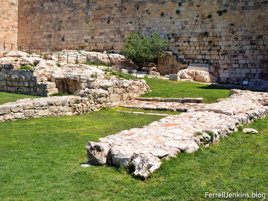
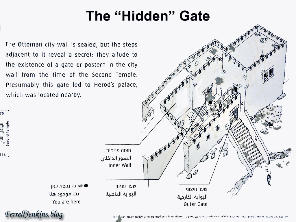
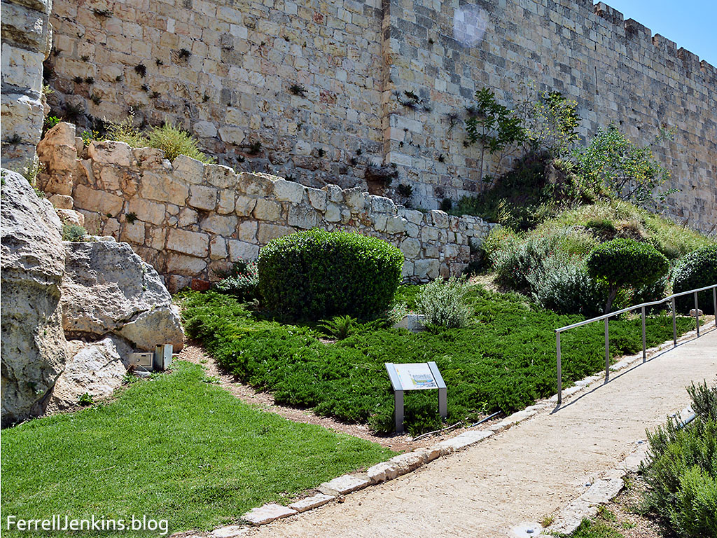
As we walk south in the garden, or along the paved path, we come to an area that looks like it might have been an approach to a gate with walls on either side. Against the Ottoman city wall we see steps but no gate in the wall. The sign at this part of the wall is labeled The “Hidden” Gate which Shimon Gibson thinks is the Gate of the Essenes.

Recognizing that there are scholars who dismiss the Gospel account of the trial of Jesus, Gibson says there is reason to take a more positive approach based on recent archaeological evidence.

This chapter cautiously argues against taking such a negative approach to the subject of the trial of Jesus as portrayed in the Gospels. The basis for this conclusion is a new study I have made on the overall layout of the palace of Herod the Great, which later became the seat of the Roman governor when in residence in Jerusalem, the praetorium. My work also highlights previously unpublished archeological discoveries pertaining to the appearance of the western gateway of the palace/praetorium, which I think is the Gate of the Essenes referred to by Josephus. This monumental gateway had inner and outer gates flanked by large towers, and these gates were separated one from the other by a large, open, and paved court at its center, with a rocky area on its north. In the first century CE, the gateway undoubtedly provided direct access to the palace grounds, which incorporated palace residences, an ornamental pleasure garden, and military barracks. Remarkably, these archeological remains fit very well with John’s description of the place of Jesus’ temporary incarceration and the trial in front of Pilate, and with the two topographical features that are mentioned by him, the lithostrotos and gabbatha. (“The Trial of Jesus at the Jerusalem Praetorium: New Archaeological Evidence,” pp. 97-118 in C.A. Evans (ed.), 2011 The World of Jesus and the Early Church: Identity and Interpretation in Early Communities of Faith. Peabody: Hendrickson.)

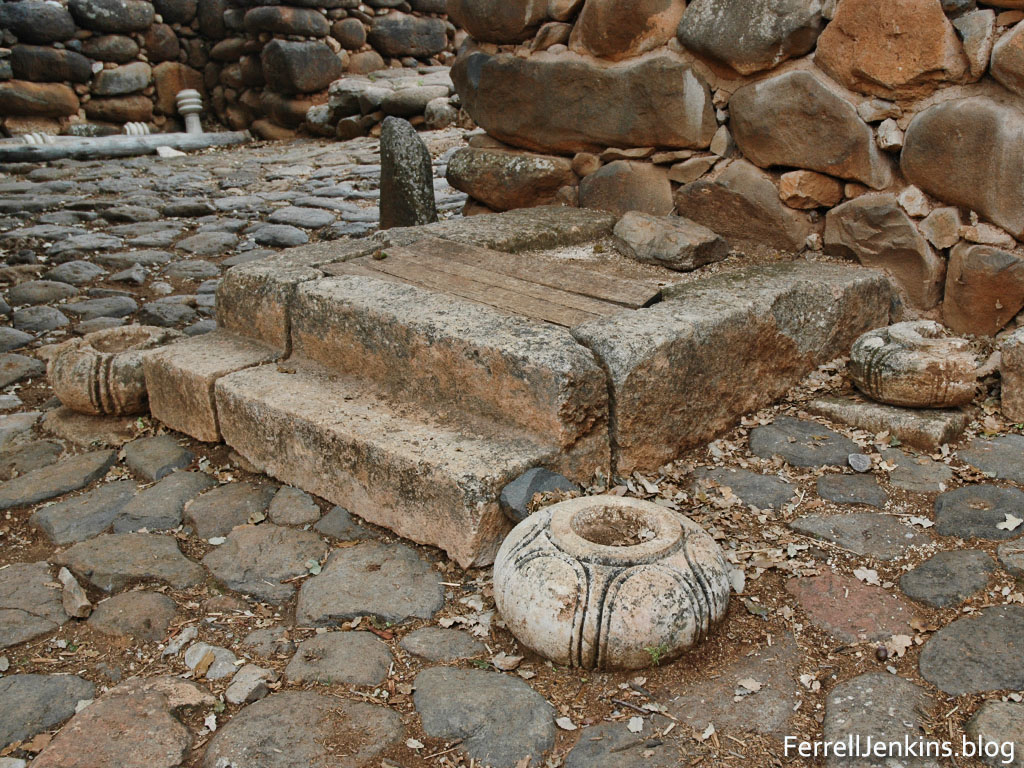
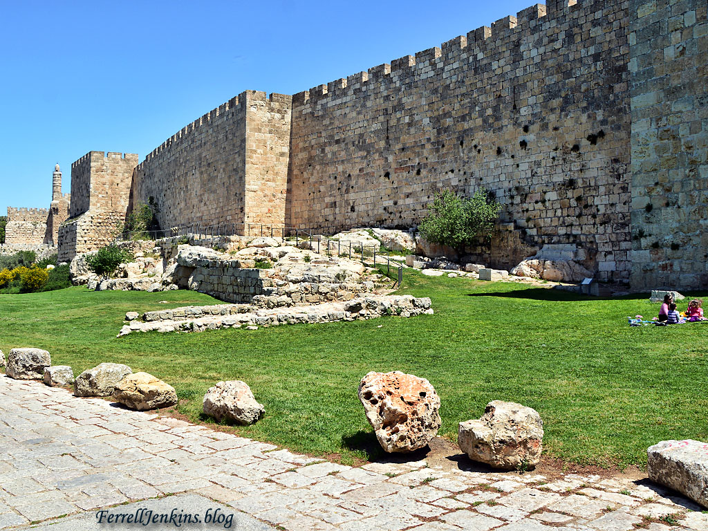
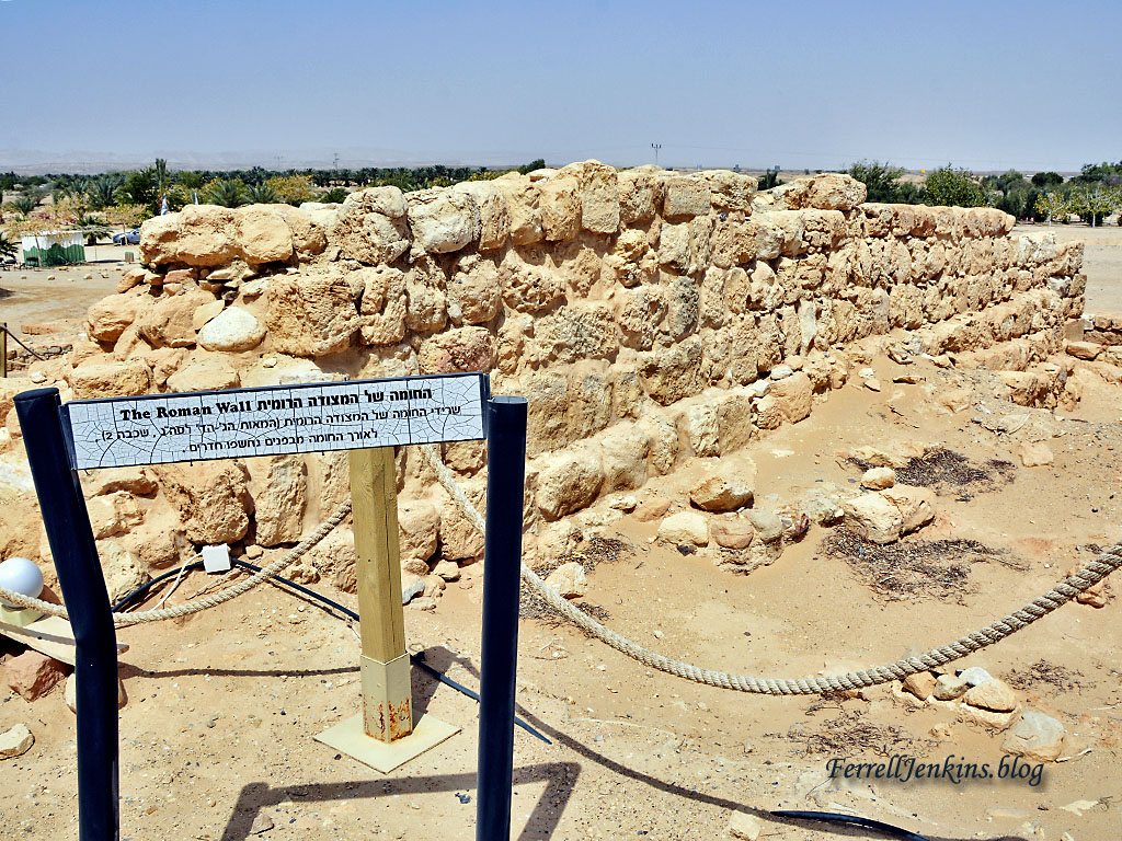
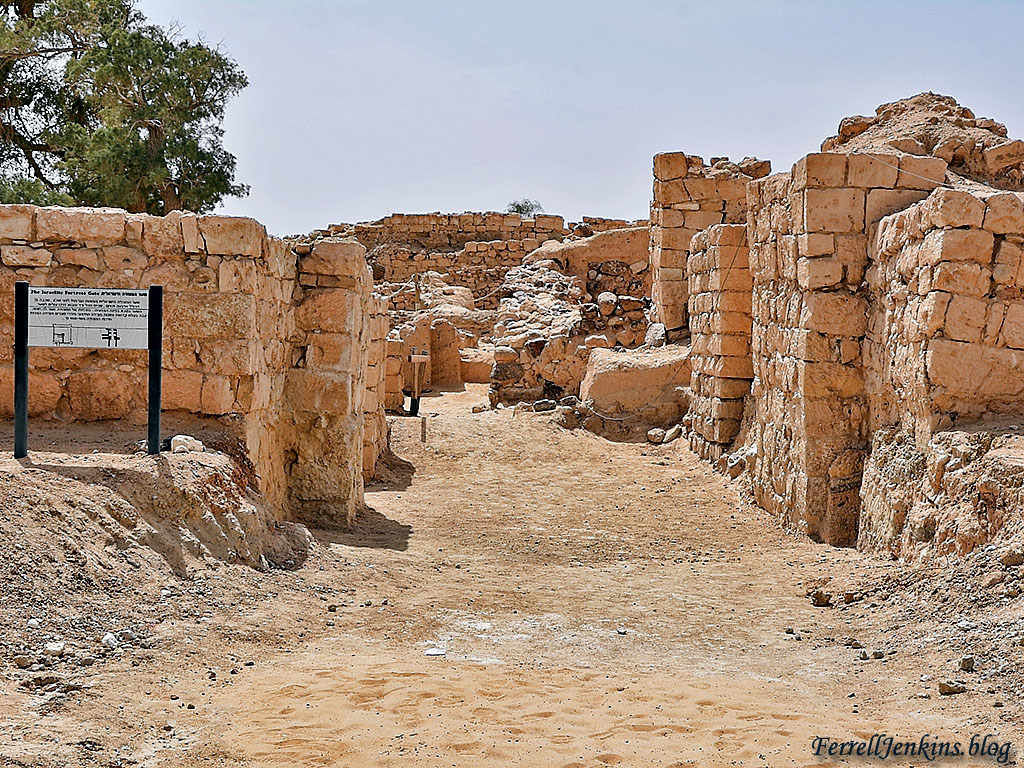
Our photo below shows the gateway approach, the stone steps leading to a gate that is no longer there, and (to the left) a bema or sort of platform where a temporary judgment seat could have been erected. All of this area was covered with earth and debris before excavations were undertaken.

The Herodian gateway approach to the Praetorium and Herodian palace. Photo by Ferrell Jenkins.

The Herodian gateway approach to the Praetorium and Herodian palace. The bema or judgment seat is the large stone to the left of the image. Photo by Ferrell Jenkins.

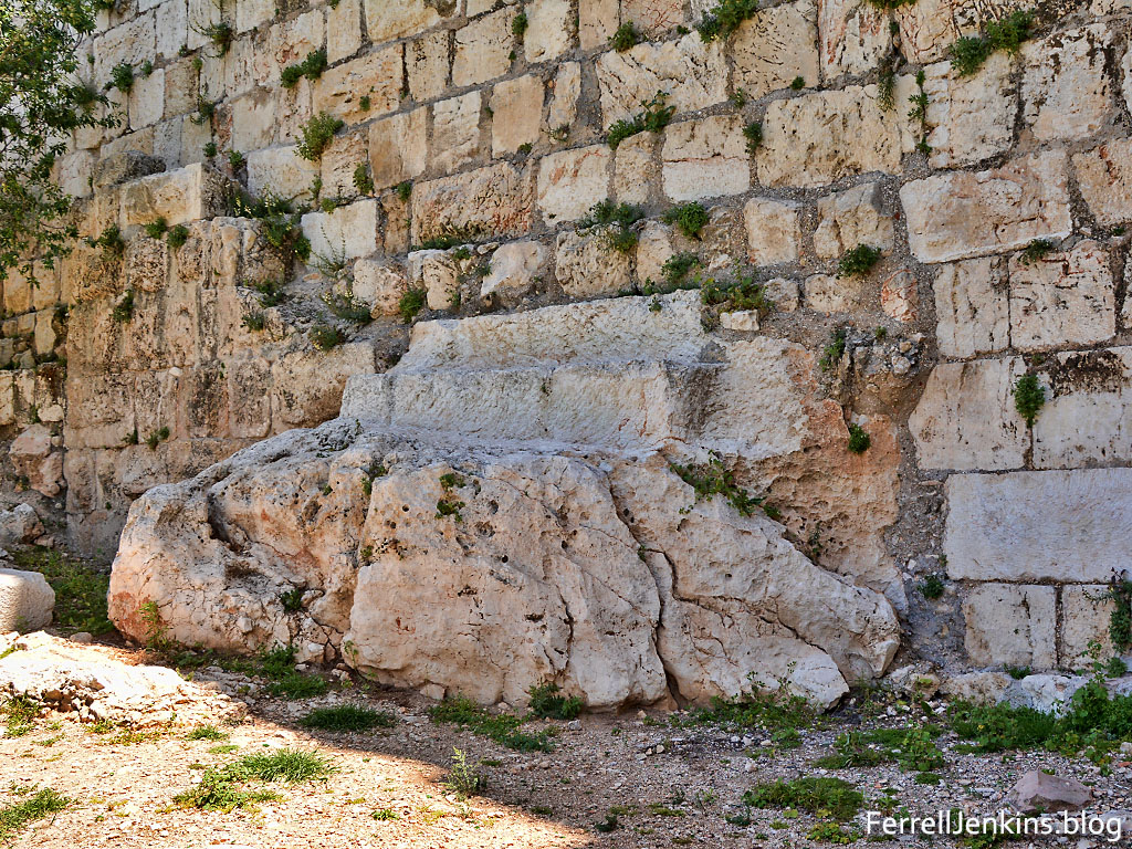
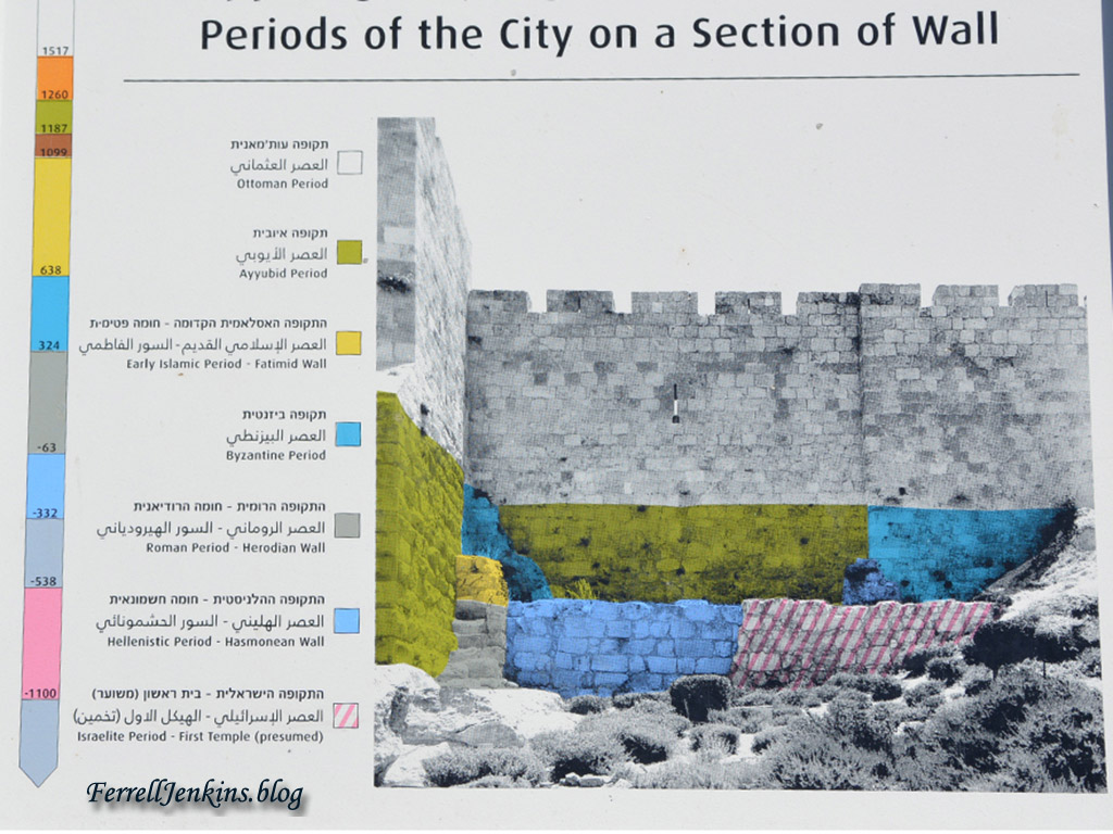
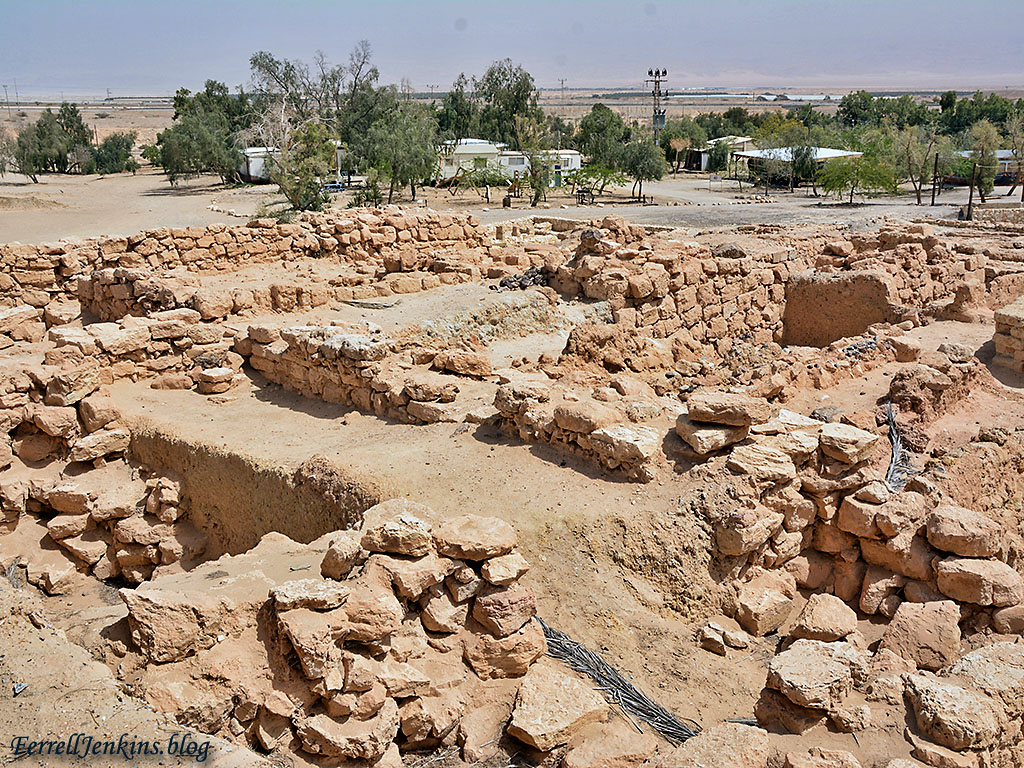
As we take a closer look at the steps cut into the bedrock and a jumble of stones of various periods built into the wall we realize that we need an illustration to help us understand what we have here.

The Hidden Gate built on bedrock. Photo by Ferrell Jenkins.

The Hidden Gate built on bedrock. Photo by Ferrell Jenkins.

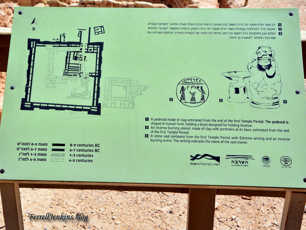
The sign at the site illustrates what has been found in the various archaeological excavations in the area. There was a gate here, designated as the “Hidden” Gate, which Gibson thinks was the Gate of the Essenes mentioned by Josephus.

Sign explaining the "Hidden" Gate in the west wall of the ancient city of Jerusalem. Photo by Ferrell Jenkins.

Sign explaining the “Hidden” Gate in the west wall of the ancient city of Jerusalem. Photo by Ferrell Jenkins.

Several excavations have taken place in the general area both inside and outside the gate (see the references at the end of this article). The sources that I list at the end of the article have good drawings to show the location of Herod’s Palace and the Praetorium.

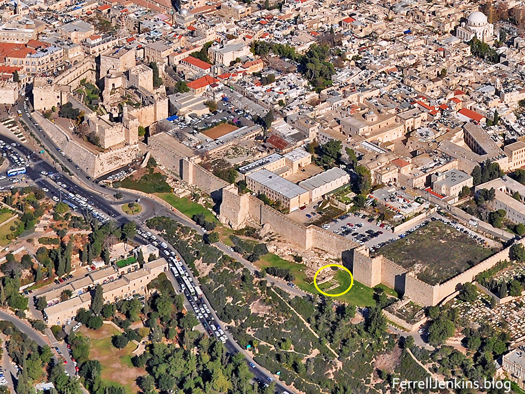
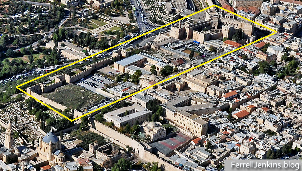
The aerial photo below begins on the left (north) with the Citadel. As we move to the right (south) we have the area of Herod the Great’s palace, then the area of the Praetorium (now known as the Armenian Garden). The gateway which is marked with a yellow circle would have been the entrance to this area. Click on the image for a larger photo.

Aerial view of the portion of the west wall under consideration. In it you will see the Citadel and the Armenian Garden. The place of the "Hidden Gate" is circled. Photo by Ferrell Jenkins.

Aerial view of the portion of the west wall under consideration. In it you will see the Citadel and the Armenian Garden. The place of the paved approach and the “Hidden Gate” is circled. Photo by Ferrell Jenkins.

Here is another aerial view made from the southeast showing the entire area from the Jaffa Gate and the Citadel to the southern wall.

Armenian Quarter of the Old City. Photo by Ferrell Jenkins.

Armenian Quarter of the Old City. Photo by Ferrell Jenkins.

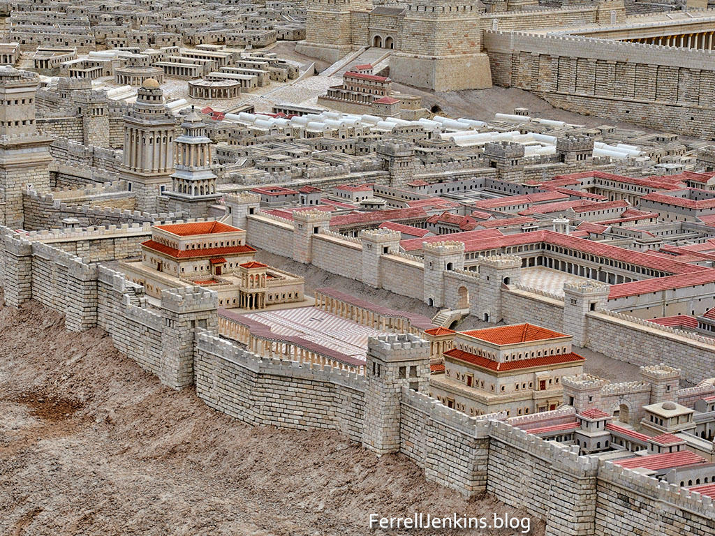
Our next photo shows the citadel and the palace of Herod the Great in the Second Temple model at the Israel Museum. The palace is shown with two buildings and a large courtyard between them. Gibson and others would make that area smaller as a square area. The “Hidden Gate” is approximately where the letter “g” of blog is located. Archaeologists point out that Herod’s palace was not a single building but a complex. The Roman prefect (governor) resided at Caesarea Maritima, but made his residence here when in Jerusalem (Matthew 27:2, 11, et al.).

The Herod ruling at the time of the crucifixion was Herod Antipas (Mark 6:21; Luke 3:1; 23:7). He was the son of Herod the Great who was Tetrarch of Galilee from 4 B.C. to A.D. 39. The Gospel account in Luke 23:1-12 agrees with the view that Antipas and Pilate were residing in close proximity to each other.

Herod's palace depicted in the Second Temple Model at the Israel Museum. Photo by Ferrell Jenkins.

Herod’s palace depicted in the Second Temple Model at the Israel Museum. Photo by Ferrell Jenkins.

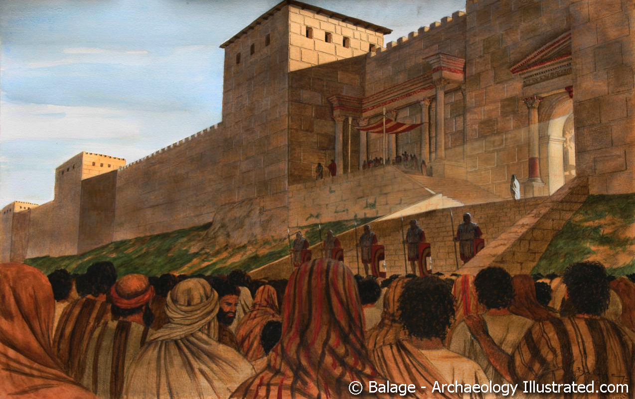
Balage (Archaeology Illustrated) has graciously allowed us to use his drawing which illustrates the viewpoint of Shimon Gibson. There are problems associated with this location. Would this be a suitable area for a crowd of Jews to gather, and how would Jesus get from here to the place of crucifixion? Gibson suggests that Jesus went back through the Praetorium. At the current time it would be easy to return to Jaffa gate and continue to Golgotha, but I do not know how easy that would have been in A.D. 33.

The site where Jesus stood before Pilate, according to Gibson. Art used by permission of Balage, Archaeology Illustrated.

The site where Jesus stood before Pilate, according to Gibson. Art used by permission of Balage, Archaeology Illustrated.

The Gospel of John provides a fairly detailed account of the movement of Pilate when he was responsible for Jesus. John states that the Jews led Jesus from the house of Caiaphas, the priestly ruler,  to the governor’s headquarters (18:28). We understand that Pilate stayed in the Palace of Herod when he visited Jerusalem.

Since the Jews would not enter the area where the Gentile Prefect was staying, Pilate “went outside to them” (v. 29), then “entered his headquarters again” (v. 33). After questioning Jesus, Pilate “went back outside to the Jews” (v. 38), then he “took Jesus and flogged him” (19:1). I take this to mean that he took Jesus back in. After Jesus was flogged, crowned with thorns, arrayed in a purple robe, and mistreated by the soldiers, Pilate “went out again” (19:4).

At this point “Jesus came out, wearing the crown of thorns and the purple robe” (v. 4). Pilate presented Jesus to the Jews with what might have been a scoffing tone: “Behold the man!” (v. 5). When the chief priests and the officers called for the crucifixion of Jesus, and heard the charge that Jesus “made himself the Son of God”, Pilate “entered his headquarters again” (v. 9) and spoke with Jesus. Pilate was unsuccessful in releasing Jesus. When the Jews threatened Pilate with no longer being a friend of Caesar, Pilate “brought Jesus out and sat down on the judgment seat at a place called The Stone Pavement and in Aramaic Gabbatha (v. 13). Further demands for the crucifixion of Jesus prompted Pilate to deliver him over to them (v. 16).

Finally, the text says that Jesus “went out, bearing his own cross, to the place called The Place of a Skull, which in Aramaic is called Golgotha. There they crucified him, and with him two others, one on either side, and Jesus between them. (vv. 17-18).

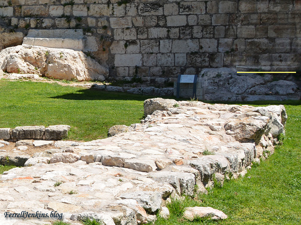
Where was the pavement? There was a pavement at this “Hidden Gate”. To the right of the steps that led through the wall you will see a section of paving just above the yellow line I have made. You must recall that the area we have been looking at did not always have this nice manicured look. Much soil and stones had to be removed by the archaeologists as they did their work.

To the right of the bedrock steps that led through the outer wall you will see a section of pavement with a yellow line below it. Photo by Ferrell Jenkins.

To the right of the bedrock steps that led through the outer wall you will see a section of pavement with a yellow line below it. Photo by Ferrell Jenkins.

Some Suggested Sources:

The major sources I used are listed by author.

Bahat, D. and M. Broshi. “Excavations in the Armenian Garden.” Jerusalem Revealed: Archaeology in the Holy City. Ed. Yigael Yadin. Jerusalem: Israel Exploration Society, 1968-1974. 55-56.

Broshi, Magen and Shimon Gibson. “Excavations Along the Western and Southern Walls of the Old City of Jerusalem.” Ancient Jerusalem Revealed. Ed. Hillel Geva. Jerusalem: Israel Exploration Society, 1994. 147-155.

Gisbson, Shimon. The Final Days of Jesus: The Archaeological Evidence. New York: Harper One, 2009.

__________. “The Trial of Jesus at the Jerusalem Praetorium: New Archaeological Evidence.” The World of Jesus and the Early Church: Identity and Interpretation in Early Communities of Faith. Ed. C. A. Evans. Peabody: Hendrickson, 2011. 97-118. *This paper is also available on Gibson’s page at Academia.edu.

Kramer, Joel, Actor. Praetorium Jerusalem Part 1 with Joel Kramer, You Tube, 2018. Accessed 24 May 2018.*There are several different videos available of Joel Kramer explaining the Praetorium.

Kramer, Joel, Actor. Praetorium, You Tube, 2015. Accessed 24 May 2018.

Walls Around Jerusalem National Park – #1

Most readers will know that the Old City of Jerusalem is surrounded by a wall built by the Ottomans in the 16th century. The Israelis have designated a park on both the east side and the west side of the Old City. The park is designated as the Walls Around Jerusalem National Park. In this post we will show you some of the highlights of the west wall.

Let’s begin at the Citadel. If you are at Jaffa Gate you should exit and follow the road that goes down to the main street. A smaller road also extends along the west wall, at which point you can walk on the grass in this beautiful garden.

The garden of Walls Around Jerusalem begins on the west at the Jaffa Gate and extends south. Photo by Ferrell Jenkins.

The garden of the Walls Around Jerusalem begins on the west at the Jaffa Gate and extends south. Photo by Ferrell Jenkins.

This extended view shows the citadel and a sizable stretch of the wall south. We will be calling special attention to the section on the right of the image.

View of the garden and the west wall of the Old City. The view is from the south. Photo by Ferrell Jenkins.

View of the garden and the west wall of the Old City. The view is from the south. Photo by Ferrell Jenkins.

Let’s go back north and begin our tour with a view of stones from various historical periods.

Jerusalem Garden Wall shows stones from various historical periods. Photo by Ferrell Jenkins.

Jerusalem Garden Wall shows stones from various historical periods. Photo by Ferrell Jenkins.

The walk in the Garden is relaxing and the signs are helpful. The captions are in Hebrew, Arabic, and English. I suggest you click on the photos to see a larger image.

There are some helpful signs providing information about the wall. Photo by Ferrell Jenkins.

There are some helpful signs providing information about the wall. This one illustrates the historical periods. Photo by Ferrell Jenkins.

The various periods represented in this little stretch of wall are listed here, beginning from the earliest at the bottom:

  • Israelite Period wall (presumable the First Temple period)
  • Hellenistic Period (a Hasmonean wall)
  • Roman Period (Herodian wall). This is the wall from the time of Christ.
  • Byzantine Period
  • Ayyubid Period
  • Ottoman Period

The next thing you will see as you walk south are rock-cut tombs from the first temple period (Iron Age). The sign explaining these tombs date to the period from 950 to 586 B.C. Notice that the tombs are cut from the bedrock, and that the wall is built on top of the tomb.

These rock-cut tombs belong to the Israelite (First Temple) period. Photo by Ferrell Jenkins.

These rock-cut tombs belong to the Israelite (First Temple) period). Photo by Ferrell Jenkins.

The sign at the tombs show the interior of the tomb complex. We see the same type tomb across the Hinnom Valley at the Ketef Hinnom tombs.

This sign shows the typical Iron Age tombs. Photo by Ferrell Jenkins.

This sign shows the typical Iron Age tombs. Photo by Ferrell Jenkins.

In this pleasant park there are also signs to identify the buildings to the west. The valley between the upper city of ancient Jerusalem and the hill to the west is the upper Hinnom Valley. Here it is running north-south, but it takes a turn to the east around the southern wall of the Old City.

Notice the green seating visible left of center among the trees in the valley. These are part of a concert venue in the Valley of Hinnom (Joshua 15:8). The ridge to the west is the central mountain ridge that runs north–south in Israel, serving as a watershed with Jerusalem on the east side of the ridge. If I added one more photo showing structures to the north (right) you would see the famous King David Hotel.  In the picture posted here you see the Montifiore Windmill, a structure built as a flour mill in the mid-19th century. (Click on the photo for a larger image.)

On the left of the photo you will see a building crane, sometimes called the national bird of Israel. Below the arm of the crane and partly framed by the yellow flowers is the Begin Center. The building to the left of it is the Scottish Church. Between the Begin Center and the Scottish Church is the location of the Ketef Hinnom (shoulder of Hinnom) iron age tombs.

View west from the west wall of Jerusalem. Photo by Ferrell Jenkins.

View west from the west wall of Jerusalem showing the valley of Hinnom and the central mountain ridge. Photo by Ferrell Jenkins.

In the next post about the west wall of the Old City we will continue south along the wall and take a look at the site that Professor Shimon Gibson, and some other scholars, have identified as an entrance to the Pretorium and the stone pavement where Jesus was tried before the Prefect Pilate (John 19:13).

Arabah – Is Eilat the Ezion-Geber of the Bible?

Arriving at Eilat, Leon and I had traveled from the foothills of Mount Hermon to the eastern arm of the Red Sea, the Gulf of Eilat (or Aqabah, depending on whether we are in Israel or Jordan).

Eilat is a popular resort town today, and it has grown tremendously since my first visit in 1973.

The resort hotels of Eilat are brightly lit at night. Photo by Ferrell Jenkins.

The resort hotels of Eilat are brightly lit at night. Photo by Ferrell Jenkins.

Is Eilat the Ezion-Geber of the Bible? Ezion-geber is said to be near Eloth (Elat, Elath, in some English versions). This area is significant in biblical history.

  • Israel camped at Ezion-geber. They journeyed from Ezion-geber and camped in the wilderness of  Zin at Kadesh (Numbers 33:35-36).
  • Ezion-geber and Elath (or Eloth) are linked together in some references (Deuteronomy 2:8; 1 Kings 9:26).
  • King Solomon built a fleet of ships in Ezion-geber. The Bible says it is near Eloth on the shore of the Red Sea, in the land of Edom. (1 Kings 9:26)

In 1938, Nelson Glueck, reported that he had found a copper-refining plant at Tell el-Kheleifeh, which he identified as Ezion-geber, on the north shore of the Gulf of Eilat/Aqabah. This site is now within Jordanian territory. Glueck identified the copper-refining plant as King Solomon’s copper mines, and explained that the apertures in the buildings served as flue holes. Through them, he thought, “the strong winds from the north-northwest entered into the furnace rooms of this structure,” which he called a “smelter, to furnish a natural draft to fan the flames.”

It is true that copper smelting was done in the Arabah in the time of Solomon, but Glueck later changed his mind about the building he had formerly identified as the refining plant. In 1962 Beno Rothenberg demonstrated that the installation at Tell el-Kheleifeh could not have been for copper smelting. Glueck was convinced by his findings that the apertures in the building “resulted from the decay and or burning of wooden beams laid across the width of the walls for bonding or anchoring purposes.” This does not affect any statement of the Bible, but it does mean that the old argument about the copper refining plant found in the Arabah is no longer valid. Glueck’s identification of Tell el-Kheleifeh with Ezion-geber is no longer accepted.

Eilat and Aqabah could be one town in better political times, but today they are separated by an almost invisible line drawn in the sand. I have never been as far south in Jordan as Aqabah, but on a clear day we can see it from Eilat, as the late afternoon photo illustrates.

The north end of the Gulf of Eilat/Aqabah. The view is to the east and the city of Aqabah, Jordan. Tell el-Kheleifeh is only a short distance north of the shore in Jordan. Photo by Ferrell Jenkins.

The north end of the Gulf of Eilat/Aqabah. The view is to the east and the city of Aqabah, Jordan. Tell el-Kheleifeh is only a short distance north of the shore in Jordan. This photo was made in January, 2011, at a time when Aqabah could be more clearly seen than late March when we recently visited. Photo by Ferrell Jenkins.

Alexander Flinder says the coastline at Tell el-Kheleifeh is a “sandy beach, with shallow water – totally unsuitable for small craft, let alone for a substantial merchant fleet” (“Is This Solomon’s Seaport?” BAR, July/August 1989, p. 38). Flinder has suggested that Ezion-geber may have been on a small island in the Gulf of Eilat/Aqabah called Jezirat Faraun (Pharaoh’s Island). It is located about seven miles south of modern Eilat, but now under Egyptian control. Flinder’s study shows that there has been an artificial harbor at this location in several historical periods and that it was characteristic of other known Phoenician ports. See the complete article for more details and photos.

Pharaoh’s Island in the Gulf of Eilat/Aqabah from the west. Photo by Ferrell Jenkins.

Pharaoh’s Island in the Gulf of Eilat/Aqabah from the west. The island is currently under Egyptian control.Photo by Ferrell Jenkins.

Meir Lubetski, The Anchor Yale Bible Dictionary, says,

Unique were the underwater archaeological findings which established the existence of an artificial enclosed harbor bordering a sizable natural anchorage, with jetties built out into the water to influence currents opposite the island on the shore of the mainland.

I can only point to a suggestion regarding the identity of Ezion-geber with Eloth (Elath). Kenneth A. Kitchen (New Bible Dictionary, 3rd ed., 1996, p. 305). says the two places were,

  • Separate stations during the Israelite wandering (Numbers 33:35-36; Deuteronomy 2:8).
  • Ezion-geber appears to be mentioned alone in the 10th-9th centuries, and is the point from which Solomon sent ships.
  • Jehoshaphat’s planned expedition from Ezion-geber was wrecked (1 King 22:48; 2 Chronicles 20:36-37).
  • King Uzziah of Judah captured Elath/Eloth from Edom and rebuilt it in the 8th century (2 Kings 14:22).
  • Ahaz lost the port to the Edomites (2 Kings 16:6).

The map at BibleAtlas.org shows the places we have discussed in this post. Notice the location of Ezion-geber is indicating, with a question mark, the location of Pharaoh’s Island.

Map of Ezion-geber, Elath, and Timnah, and a portion of the Arabah. Biblos.com.

Map of Ezion-geber, Elath, and Timnah, and a portion of the Arabah. BibleAtlas.com.

We plan next to visit Timna and learn about the copper mining in the area.

The Arabah: Has Tamar, Solomon’s desert fortress, been located?

The Tamar Biblical Park is located about 20 miles south of the southern end of the Dead Sea. We can suggest several reasons why the site was settled in many biblical periods. The spring at the site made it immediately attractive to travelers, and in fact the site was “the central gateway from Edom and Arabia enroute to Beershebe and Ashkelon for incense and copper trade” (Bowman, Biblical Tamar, Bible and Interpretation).

Road sign on Hwy 90 at the junction with Hwy 227. The site is at Hazeva. Photo by Ferrell Jenkins.

Road sign on Hwy 90 at the junction with Hwy 227. The Biblical Tamar Park is at En (spring) Hazeva. In earlier years there was a now-defunct kibbutz named Ir Ovat because the founders thought this was the site of biblical Oboth, one of the places the Israelites camped when they wandered in the wilderness (Numbers 21:10). Photo by Ferrell Jenkins.

I have a Promote GPS device which I sometimes use with my camera. If I am patient and take time for it to connect to satellites I can usually be assured of about one out of four shots showing the location as well as the elevation. The elevation here is 137 meters (about 450 feet) below sea level.

The GPS location of Tamar Biblical Park.

The GPS location of Tamar Biblical Park.The red pointer is at the Iron Age gate. Enter 29 58.0659’N, 35 3.599 9’E in Google Earth.

The Biblical Tamar Park is curated by a private Christian group called Blossoming Rose, but excavations were carried out under the direction of the Israel Antiquities Authority. A source tells me that the IAA did not show much interest in the site even though they acknowledge the importance of the discoveries. One can understand why a site like this which is not on the main tourist routes would be of less interest than those that are.

The Blossoming Rose organization has placed nice signs to identify the various periods under consideration. Instead of just referring to the Bronze Age or the Iron Age, Blossoming Rose mentions the seven historic periods that are identifiable here. (1) Abrahamic Period; (2) Moses Period; (3) Israelite Period; (4) Roman-Christian Period; (5) Islamic Period; (6) British Period; (7) Israeli Period.

The Bible says that Solomon built Tamar in the wilderness.

so Solomon rebuilt Gezer) and Lower Beth-horonand Baalath and Tamar in the wilderness, in the land of Judah, (1 Kings 9:17-18 ESV)

Could this be that site? It is possible. I must be selective in the photos I present. Here goes. The first one is of a Roman period wall. There is also a large cistern dating to this period. And, yes, the Romans built a bath at Tamar.

A Roman Wall at Tamar Biblical Park. Photo by Ferrell Jenkins.

Portion of a Roman wall at Tamar. Photo by Ferrell Jenkins.

The next photo shows the ruins of what is called the Hazeva Fort, a structure said to date to the 10th century B.C., the time of King Solomon.

An Iron Age fortress at Tamar. Photo by Ferrell Jenkins.

Fortress dating to the time of King Solomon at Tamar. Photo by Ferrell Jenkins.

This sign shows the footprint of the fortress during various periods as well a drawing of an Edomite stone seal from the first Temple Period with Edomite writing and an incense burning scene.

Sign at Tamar showing layout of the Iron Age fortress. Photo by Ferrell Jenkins.

Sign at Tamar showing layout of the Iron Age fortress and some artifacts belonging to the Edomites. Photo by Ferrell Jenkins.

On the right side of the sign above there is a drawing of “an incense burning utensil.” The Edomite shrine is displayed in the Israel Museum, Jerusalem. The Chronicles of the Land: Archaeology in The Israel Museum Jerusalem says,

Tangible evidence for foreign cults has been revealed at Hazeva in the Arava, where a pit containing ritual objects from an Edomite shrine was discovered. The objects, offerings brought to the shrine, had been deliberately smashed after they could no longer be used and buried in the pit. Among them were human shaped ritual stands, which may have represented the worshipers themselves. These objects highlight one of the sharp contrasts between Edomite and Judahite public worship, the latter avoiding the human image. (p.77)

Many see this destruction in the light of the reforms of King Josiah of Judah (2 Kings 23).

The ritual stands found here date to the late 7th – early 6th century B.C. Our next photo shows the display in the Israel Museum.

Edomite shrine assemblage from Hazeva (Tamar) in the Israel Museum. Photo by Ferrell Jenkins.

Edomite shrine assemblage from Hazeva (Tamar) in the Israel Museum. Photo by Ferrell Jenkins.

The next photo may show the prize of Tamar, a four chamber gate which is labeled as the Israelite Fortress Gate.

Iron Age gate, possibly Solomonic, at Tamar. Photo by Ferrell Jenkins.

Iron Age gate, possibly Solomonic, at Tamar. Photo by Ferrell Jenkins.

I was impressed with the four-room house. Avraham Faust describes the four-room house.

The term four-room house is a generic term which refers to a new type of house which became extremely popular and dominant during the Iron Age. The “ideal type” of this structure is a long house with four main spaces or areas: a broad room at the back, and three long spaces stemming forward from it. These long rooms were typically (though not always) divided by a combination of stone pillars and walls. The entrance was usually located in the central (long) room. Not all houses, however, follow precisely this “ideal” plan, and there is some variation, mainly in the number of long rooms. One can therefore refer to three-, four-, and five-room houses (though all subtypes are usually referred to by the name “four-room house”). Variation also exists in the form of inner division(s) of the rooms, due probably to the lifecycle of the family. Apart from this, the basic plan is quite rigid and easy to identify. (Encyclopedia of the Bible, p. 564).

Four room house at Tamar. Photo by Ferrell Jenkins.

Four room house at Tamar. Photo by Ferrell Jenkins.

Next to water, shade is one of the most important things for settlers and travelers. There is a large Jujube tree, better known by  it’s technical name Ziziphus spina-christi, Christ’s thorn Jujube. Ami Tamir includes a photo and description of this tree in his Sacred Flowers: Holy Trees & Blessed Thorns (pp. 89-92). We reviewed this Carta Guide Book here. Tamir explains how the thorns develop on the tree.

A Jujube tree at Tamar, said by some to be the oldest tree in Israel. Photo by Ferrell Jenkins.

A Jujube tree (Ziziphus spina christi) at Tamar, said by some to be the oldest tree in Israel. The popular name for this tree is Thorn of the Messiah. Photo by Ferrell Jenkins.

The Pictorial Library of the Bible Lands includes several good photos of Tamar in the volume on Negev and the Wilderness. See details here.

BibleWalks.com includes several good drone aerial photos in their discussion of Tamar.

I trust you have enjoyed our lengthy visit to Tamar Biblical Park. Our next stop is planned for Keturah where we will see the ancient palm named Methuselah.

The Arabah – the northern end

When we speak of the Arabah (or Aravah, in Israel) we are speaking of the part of the Great Rift that begins at the south end of the Dead Sea and continues to Eilat. The distance is about 196 kilometers (121 miles). The Arabah is more or less the divider between Israel on the west and Jordan one the east. At some points the main Israeli highway 90 almost touches the Jordanian border.

Immediately south of the Dead Sea there are many mining installations processing the many minerals available in the Dead Sea. For several miles we continue to see the cliffs along the road, especially on the west side.

Cliffs on the west side of the Arabah a few miles south of the Dead Sea. Photo by Ferrell Jenkins.

Cliffs on the west side of the Arabah a few miles south of the Dead Sea. Photo by Ferrell Jenkins.

I pulled down the August, 1965, issue of National Geographic to look at the article by Helen and Frank Schreider “Journey into the Great Rift” that I recalled reading many years ago.  The authors describe the stretch of the Great Rift Valley between the Dead Sea and the Gulf of Aqaba as they were calling it at the time.

South of the Dead Sea, the Great Rift Valley forms a rounded trough that narrows to the Gulf of Aqaba, then broadens again into the Red Sea. Wild, dry country it is, as lifeless today as when trains of camels carried frankincense and myrrh from Yemen to Damascus; as forbidding as when the Nabateans, at the time of Christ. preyed on the caravans and lavished the booty on their capital at Petra. (p. 275)

While there is some difference in the terrain along the way, the entire stretch is desert. The photos I wish to share show the typical wadis that run north to south in the valley. This photo shows a wide dry wadi or desert ravine. When it rains in the hills to the west water rushes like a torrent and floods the wadi. Click on the photo for a larger image. You will be able to see various levels where the water has cut along the sides of the wadi.

We always see a line of shrubs in the last place the water runs before soaking into the earth or totally evaporating.

View northwest in the Arabah. This wadi can rage with water after rains in the hills to the west. Photo by Ferrell Jenkins.

View northwest in the Arabah. This wadi can rage with water after rains in the hills to the west. Photo by Ferrell Jenkins.

Next is a photo looking to the southwest. The hills to the west are lower, but still a lot of water comes down from the central mountain range.

Arabah view to the southwest. Photo by Ferrell Jenkins.

Arabah view to the southwest. Photo by Ferrell Jenkins.

These photos may leave one with the impression that the wadis are harmless, but I can assure you this is not the case. A few years ago I had the unusual opportunity to see the effect of the spring rains in the central mountain rain had on the wadis in the valley. The particular photo shows water rushing down Wadi Kelt (Qelt) at Jericho in a ravine that is normally dry. For more information about this event take a look at my earlier posting here.

Wadi Kelt at Jericho after heavy rains in the central mountains range April 2, 2006. Photo by Ferrell Jenkins.

Wadi Kelt at Jericho after heavy rains in the central mountains range April 2, 2006. Photo by Ferrell Jenkins.

Just last week the Israeli papers reported on ten (about 18 year old) teenagers who died when they were swept away by a sudden burst of water while they were hiking in Nahal (Wadi) Tsafit in the desert west of the southern end of the Dead Sea.

Here is a close view of one of the Acacia trees in the Arabah wadi.

Close view of an Acacia tree in the Arabah. Photo by Ferrell Jenkins.

Close view of an Acacia tree in the Arabah. Photo by Ferrell Jenkins.

I am including a photo of the leaves of the tree for your consideration. My knowledge of the various flora of the Middle East is limited, but the best I have been able to determine this is an Acacia tortillis. I would be pleased to have comments from someone more knowledgeable on this subject.

Leaves of the Acacia tortillis in the Arabah. Photo by Ferrell Jenkins.

Leaves of the Acacia tortillis in the Arabah. Photo by Ferrell Jenkins.

When the wadi dries up the only comfort left is the shade of a small tree such as this. We have an example of this in the account of Hagar and Ishmael.

When the water in the skin was gone, she put the child under one of the bushes. (Genesis 21:15 ESV)

Our next stop in the Arabah will be at the possible site of Solomon’s “Tamar in the wilderness” (1 Kings 9:17-19).