Category Archives: Archaeology

Crusader period hospital building in Jerusalem

The Israel Antiquities Authority announced yesterday that a building from the Crusader period (1099–1291 A.D.) has been excavated. The building is in an area of the Christian Quarter of Jerusalem known as the Muristan (“a corruption of the Persian word for hospital”). Our first photo shows part of the Muristan near the old structure. You can see the tower of the Lutheran Church of the Redeemer. This is near the Church of the Holy Sepulcher.

The Muristan in the Christian Quarter of the Old City of Jerusalem. The tower of the Lutheran Church of the Redeemer is visible. Photo by Ferrell Jenkins.

The Muristan in the Christian Quarter of the Old City of Jerusalem. The tower of the Lutheran Church of the Redeemer is visible. Photo by Ferrell Jenkins.

Between the Lutheran Church and the Armenian Quarter on Muristan Street stands a monument identifying the area where the hospital of St. John of Jerusalem was established. Click on the image if you wish to read the inscription.

Marker identifying the location of the hospital built by the "Order of St. John of the Hospital in Jerusalem." Photo by Ferrell Jenkins.

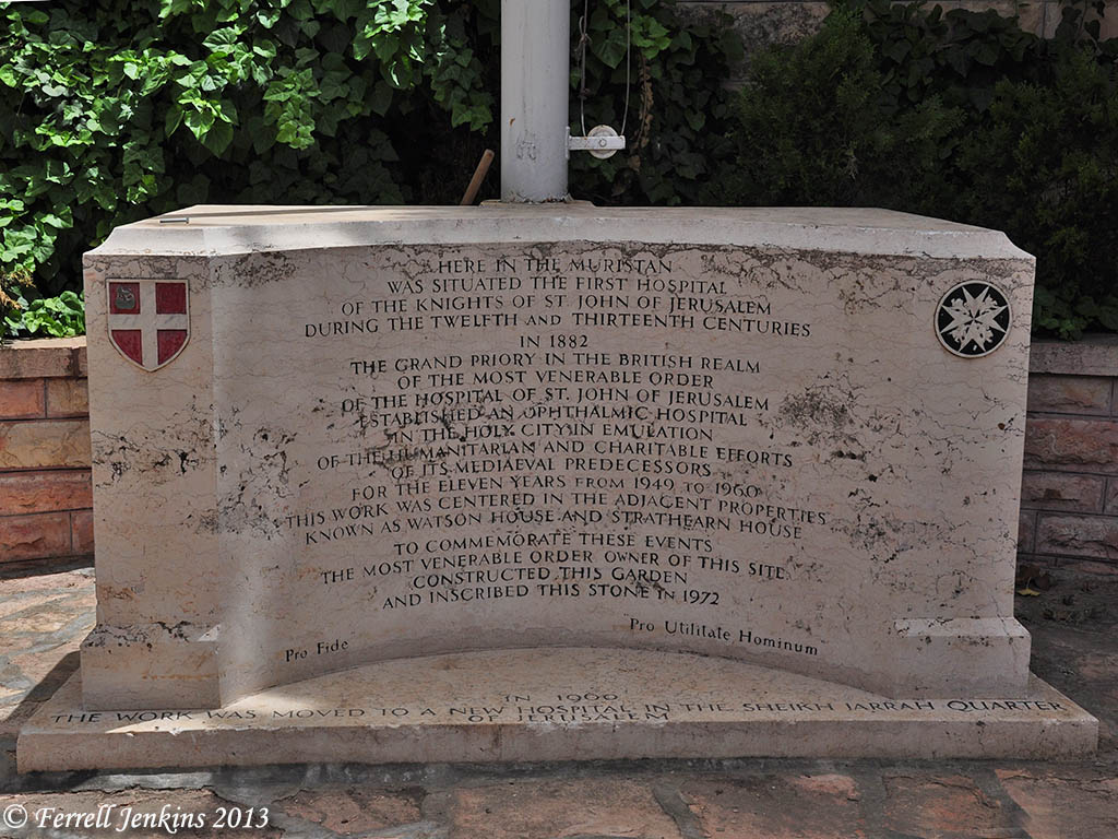
Marker identifying the location of the hospital built by the “Order of St. John of the Hospital in Jerusalem.” Photo by Ferrell Jenkins.

The Press Release contains several bits of historical information that may be of interest to readers. Here is the full Press Release.

— ♦ —

The Israel Antiquities Authority conducted an excavation in the impressive Crusader building, which is similar in appearance to the Knights Halls in Akko and stands 6 meters high, prior to the construction of a restaurant by the Grand Bazaar Company

Part of an enormous structure dating to the Crusader period (1099–1291 CE), which was a busy hospital,  has currently been revealed to the public following excavations and research by the Israel Antiquities Authority there in cooperation with the Grand Bazaar Company of East Jerusalem. The building, owned by the Waqf, is situated in the heart of the Christian Quarter in the Old City of Jerusalem, in a region known as “Muristan” (a corruption of the Persian word for hospital), near David Street, the main road in the Old City.

Until a decade or so ago the building served as a bustling and crowded fruit and vegetable market. Since then it stood there desolate. In the wake of the Grand Bazaar Company’s intention to renovate the market as a restaurant, the Israel Antiquities Authority conducted archaeological soundings there.

The structure, only a small part of which was exposed in the excavation, seems to extend across an area of fifteen dunams! Its construction is characterized by massive pillars and ribbed vaults and it stands more than six meters high. The image we have is that of a great hall composed of pillars, rooms and smaller halls.

Ruins of the Crusader hospital built by the Order of St. John of the Hospital in Jerusalem. Yoli Shwartz, courtesy of the Israel Antiquities Authority.

Ruins of the Crusader hospital built by the Order of St. John of the Hospital in Jerusalem. Photo by Yoli Shwartz, courtesy of the Israel Antiquities Authority.

According to Renee Forestany and Amit Re’em, the excavation directors on behalf of the Israel Antiquities Authority, “We’ve learned about the hospital from contemporary historical documents, most of which are written in Latin.  These mention a sophisticated hospital that is as large and as organized as a modern hospital. The hospital was established and constructed by a Christian military order named the “Order of St. John of the Hospital in Jerusalem” and known by its Latin name the Hospitallers (from the word hospital). These righteous warriors took an oath to care for and watch over pilgrims, and when necessary they joined the ranks of the fighters as an elite unit.

The hospital was comprised of different wings and departments according to the nature of the illness and the condition of the patient – similar to a modern hospital. In an emergency situation the hospital could accept as many as 2,000 patients. The Hospitallers treated sick men and women of different religions. There is information about Crusaders who ensured their Jewish patients received kosher food. All that notwithstanding, they were completely ignorant in all aspects of medicine and sanitation: an eyewitness of the period reports that a Crusader doctor amputated the leg of a warrior just because he had a small infected wound – needless to say the patient died. The Muslim Arab population was instrumental in assisting the Crusaders in establishing the hospital and teaching them medicine. Arab culture has always held the medical profession in high regard and Arab physicians were famous far and wide.

In addition to the medical departments, the hospital also functioned as an orphanage where abandoned newborns were brought. Mothers who did not want their offspring would come there with covered heads and hand over their infants. In many instances when twins were born, one of them was given to the orphanage. The orphans were treated with great devotion and when they reached adulthood they served in the military order.

We can learn about the size of the hospital from contemporary documents. One of the documents recounts an incident about a staff member who was irresponsible in the performance of his work in the hospital. That person was marched alongside the building awhile, and the rest of the staff, with whips in hand, formed a line behind him and beat him. This spectacle was witnessed by all of the patients.

The Ayyubid ruler Saladin lived near the hospital following the defeat of the Crusaders, and he also renovated and maintained the structure. He permitted ten Crusader monks to continue to reside there and serve the population of Jerusalem.

The building collapsed in an earthquake that struck in 1457 CE and was buried beneath its ruins, which is how it remained until the Ottoman period. In the Middle Ages parts of the structure were used as a stable and the bones of horses and camels were found in excavations, alongside an enormous amount of metal that was used in shoeing the animals.

According to Monser Shwieki, the project manager, “The magnificent building will be integrated in a restaurant slated to be constructed there, and its patrons will be impressed by the enchanting atmosphere of the Middle Ages that prevails there”. According to Shwieki, “The place will be open to the public later this year”.

Click here to download high resolution pictures . Photograph credit: Yoli Shwartz, courtesy of the Israel Antiquities Authority.

HT: Joseph I. Lauer

A sunrise few have seen

Trent and Rebekah are “vagabonding” for forty days in Israel between the close of the Ashkelon excavation and the opening of their fall semester at Jerusalem University College (also known as the American Institute of Holy Land Studies). Last Thursday morning they were at Masada for the sunrise. I didn’t ask if they spent the night there.

This view from Masada to the east at sunrise is one I have not seen. They graciously allowed me to post it here.

Sunrise from Masada. Photo by Trent and Rebekah, Aug. 01, 2013.

Sunrise from Masada. Photo by Trent and Rebekah, Aug. 01, 2013.

There is more to this photo than just the beauty of it. In their photo you see the Lisan (or Tongue) that extends from the east into the Dead Sea. You may also see the canal through which water is pumped to the southern end of the Sea.

The photo below was made near mid-day from Masada.

View east from Masada near mid-day. Photo by Ferrell Jenkins.

View east from Masada near mid-day. Photo by Ferrell Jenkins.

The same photo below has been enhanced further in Photoshop to reveal the details a little better.

View from Masada (enhanced to show features). Photo by Ferrell Jenkins.

View east from Masada (enhanced to show features). Photo by Ferrell Jenkins.

Last month I wrote about “The topography of Kir-hareseth” here. This map shows the valley that goes down from the Transjordan Plateau in a northwesterly direction to the Lisan Peninsula (tongue) of the Dead Sea. Masada is located directly across from that valley. The Lisan now extends completely across the Dead Sea, as the photos above show. Water is pumped to the southern end of the Sea to allow for the chemicals and minerals to be mined.

Map of the southern end of Dead Sea.

Map of the southern end of Dead Sea. Today the Lisan extends completely across the Dead Sea.

Dr. Rasmussen (HolyLandPhotos’Blog) says,

The Dead/Salt Sea can be divided into two unequal sections by a tongue-shaped peninsula that protrudes into it from the eastern shore (= Lisan in Arabic, Lashon in Hebrew). – Zondervan Atlas of the Bible, 49.

Trent and Rebekah continue to post about the places they are visiting in Israel. Take a look at TrentandRebekah.wordpress.com.

Seeking the history beneath Solomon’s city at Gezer

Southwestern Baptist Theological Seminary has released information about the most recent season of archaeology at Tel Gezer here.

Aerial view of Tel Gezer toward the coastal plain, SW from the site. Photo by Ferrell Jenkins.

Southwest aerial view of Tel Gezer toward the coastal plain. Photo by Ferrell Jenkins.

This summary of the most recent season was written by Steven Ortiz and Samuel Wolff.

The excavations at Gezer are sponsored by the Tandy Institute of Archaeology at Southwestern Baptist Theological Seminary with several consortium schools. The excavations are directed by Steven Ortiz of the Tandy and Samuel Wolff of the Israel Antiquities Authority.

In this, the sixth season of excavation, one goal was to remove a portion of the city wall built in the Iron IIA period (10th century BCE) in order to investigate a Late Bronze age destruction level (ca. 1400 BCE) that lay below it. To the surprise of the team, in the process of excavating the city wall, an earlier wall system dating to the Iron Age I (1200-1000 BCE) was discovered. This wall was one meter thick with several rooms attached to it. These rooms were filled by a massive destruction, nearly one meter in height,that included Canaanite storage jars, Philistine pottery and other items. A fragment of a Philistine figurine was also found this season. The biblical text record that the king of Gezer organized a Canaanite coalition against Joshua and David had a battle with the Philistines where he chased them “all the way to Gezer.” Perhaps the biblical accounts retain a memory of the importance of Gezer and its close relations to the Philistines during this period.

Beneath this city was an earlier city that was destroyed in a fierce conflagration. This city was functioning during the Egyptian 18th Dynasty’s rule over the southern Levant. Within the destruction debris were several pottery vessels along with a cache of cylinder seals and a large Egyptian scarab with the cartouche of Amenhotep III. This pharaoh was the father of the heretic King Akenaton and grandfather of the famous Tutankhamun (King Tut). This destruction corresponds to other destructions of other cities in the region, a reflection of the internecine warfare that was occurring between the Canaanite cites as reflected in the well-known Tell el-Amarna correspondence.

The archaeology of Solomon has been controversial, fueled by various theories over the dating of the archaeological record. The dating of the Gezer Iron Age Gate is at issue. The Gezer expedition is slowly stripping away layers of public and domestic structures of the 8th and 9th centuries BCE in order to reveal the 10th century city plan adjacent to the City Gate. This summer the tops of the 10th century walls began to poke out, making the archaeologists optimistic that in future seasons more of the Solomonic city will be exposed.

For more information see www.telgezer.com.

Steven Ortiz, professor of archaeology at Southwestern Seminary, is co-director of the archaeological excavations at Tel Gezer, site of one of the famed cities of Solomon located between Jerusalem and Tel Aviv.  Photo by Matt Miller.

Steven Ortiz, professor of archaeology at Southwestern Seminary, is co-director of the archaeological excavations at Tel Gezer, site of one of the famed cities of Solomon located between Jerusalem and Tel Aviv. Photo by Matt Miller.

For earlier posts about Gezer, see the following: aerial photo with a view toward the hill country, boundary stones, and the water system.

HT: Joseph Lauer

Has “King David’s Palace” been uncovered in the Judean Shephelah

Archaeological digs in Israel are winding down and the maximalists are having a great time. Today’s report comes from the excavation of Khirbet Qeiyafa which is conducted jointly by Professor Yossi Garfinkel of the Hebrew University and Saar Ganor of the Israel Antiquities Authority.

Aerial photo of Khirbet Qeiyafa. Photo: Sky View, courtesy of the Hebrew University and the Israel Antiquities Authority.

Aerial photo of Khirbet Qeiyafa. Photo: Sky View, courtesy of the Hebrew University and the Israel Antiquities Authority.

Here is today’s Press Release from the Israel Antiquities Authority.

King David’s Palace was Uncovered in the Judean Shephelah

Royal storerooms were also revealed in the joint archaeological excavation of the Hebrew University and the Israel Antiquities Authority at Khirbet Qeiyafa ***
These are the two largest buildings known to have existed in the
tenth century BCE in the Kingdom of Judah 

Two royal public buildings, the likes of which have not previously been found in the Kingdom of Judah of the tenth century BCE, were uncovered this past year by researchers of the Hebrew University and the Israel Antiquities Authority at Khirbet Qeiyafa – a fortified city in Judah dating to the time of King David and identified with the biblical city of Shaarayim.

One of the buildings is identified by the researchers, Professor Yossi Garfinkel of the Hebrew University and Saar Ganor of the Israel Antiquities Authority, as David’s palace, and the other structure served as an enormous royal storeroom.

Today (Thursday) the excavation, which was conducted over the past seven years, is drawing to a close. According to Professor Yossi Garfinkel and Sa’ar Ganor, “Khirbet Qeiyafa is the best example exposed to date of a fortified city from the time of King David. The southern part of a large palace that extended across an area of c. 1,000 sq m was revealed at the top of the city. The wall enclosing the palace is c. 30 m long and an impressive entrance is fixed it through which one descended to the southern gate of the city, opposite the Valley of Elah.  Around the palace’s perimeter were rooms in which various installations were found – evidence of a metal industry, special pottery vessels and fragments of alabaster vessels that were imported from Egypt. The palace is located in the center of the site and controls all of the houses lower than it in the city. From here one has an excellent vantage looking out into the distance, from as far as the Mediterranean Sea in the west to the Hebron Mountains and Jerusalem in the east. This is an ideal location from which to send messages by means of fire signals. Unfortunately, much of this palace was destroyed c. 1,400 years later when a fortified farmhouse was built there in the Byzantine period”.

A pillared building c. 15 m long by 6 m wide was exposed in the north of the city, which was used as an administrative storeroom. According to the researchers, “It was in this building the kingdom stored taxes it received in the form of agricultural produce collected from the residents of the different villages in the Judean Shephelah. Hundreds of large store jars were found at the site whose handles were stamped with an official seal as was customary in the Kingdom of Judah for centuries”.

An aerial picture of the "palace" and the Byzantine farmhouse. Photograph: Sky View, courtesy of the Hebrew University and the Israel Antiquities Authority.

An aerial picture of the “palace” and the Byzantine farmhouse. Photograph: Sky View, courtesy of the Hebrew University and the Israel Antiquities Authority.

The palace and storerooms are evidence of state sponsored construction and an administrative organization during King David’s reign. “This is unequivocal evidence of a kingdom’s existence, which knew to establish administrative centers at strategic points”, the archaeologists say. “To date no palaces have been found that can clearly be ascribed to the early tenth century BCE as we can do now. Khirbet Qeiyafa was probably destroyed in one of the battles that were fought against the Philistines circa 980 BCE. The palace that is now being revealed and the fortified city that was uncovered in recent years are another tier in understanding the beginning of the Kingdom of Judah”.

Finds from the site. Photographic Credit: Clara Amit, courtesy of the Israel Antiquities Authority.

Finds from the site. Photo: Clara Amit, courtesy of the Israel Antiquities Authority.

The exposure of the biblical city at Khirbet Qeiyafa and the importance of the finds discovered there have led the Israel Antiquities Authority to act together with the Nature and Parks Authority and the planning agencies to cancel the intended construction of a new neighborhood nearby and to promote declaring the area around the site a national park. This plan stems from the belief that the site will quickly become a place that will attract large numbers of visitors who will be greatly interested in it, and from it one will be able to learn about the culture of the country at the time of King David.

Comments: It is often true in the media that the headlines say more than the article. This seems to be the case here. I understand this Press Release to be saying that a large structure, called a palace (don’t think Buckingham!) has been found. There is evidence of “a metal industry, special pottery vessels and fragments of alabaster vessels that were imported from Egypt.” Whether these things are to be associated directly with the David (1010–970 B.C.) we read about in the Bible is a matter of interpretation.

I note that the aerial photo of the site is an older one; it does not show the structures we see in the recent closeup of the “palace” and Byzantine farmhouse. (Correction: See the correction by Luke Chandler in the comments below.)

Todd Bolen’s comment this morning is worth heeding.

To my conservative friends, I’d urge caution before making any bold claims based on Garfinkel’s work. Or any claims at all. Let’s wait and see how credible archaeologists evaluate his stratigraphy. If he’s correct, we’ve lost nothing by being patient.

I see that Todd has added several updates and links to the Israeli papers also. Take a look here.

Welcome back Todd. We have missed your posts and insightful comments.

Ninth century B.C. chalices uncovered at Gath

A few chalices dating to the time of the destruction of the Philistine city of Gath by Hazael, king of Aram (Syria), have been announced during the current excavation at Tel es-Safi/Gath. The most recent, larger than usual, chalice was announced by Prof. Aren Maeir on Monday and Tuesday. Follow the excavation reports here.

Jar and chalice in Area D at Tel es-Safi/Gath. Photo: Tell es-Safi/Gath Archeological Project.

Jar and chalice (upside down beside the balk) in Area D at Tel es-Safi/Gath. Photo: Tell es-Safi/Gath Archeological Project.

Prof. Maeir displays the large chalice after the stand was excavated. (I like the T-shirt. Maybe there is another step down — a human stooped over with a mobile phone.)

Prof. Aren Maeir displays the large chalice uncovered this week at Tel es-Safi/Gath. Jar and chalice in Area D at Tel es-Safi/Gath. Photo: Tell es-Safi/Gath Archeological Project.

Prof. Aren Maeir displays the large chalice uncovered this week at Tel es-Safi/Gath. Jar and chalice in Area D at Tel es-Safi/Gath. Photo: Tell es-Safi/Gath Archeological Project.

Vessels of this type were sometimes used for burning incense.

Gath was one of five cities of the Philistine Pentapolis (1 Samuel 6:17). The city was destroyed by the Aramean King Hazael shortly after the middle of the 9th century B.C.

At that time Hazael king of Syria went up and fought against Gath and took it. But when Hazael set his face to go up against Jerusalem, (2 Kings 12:17 ESV)

Joseph Lauer calls attention to a nice article about the find in The Jerusalem Post here. The author of the article is Joshua Lipson. Joshua volunteered at the Tel es-Safi/Gath excavation a few years ago.

And thanks to Prof. Maeir for posting the nice photos. No good reason to hide discoveries like this.

The reforms of Hezekiah

After the death of Solomon, the nation of Israel divided into Israel (the northern kingdom) and Judah (the southern kingdom). With the introduction of calf worship by Jeroboam, the kingdom of Israel never recovered. Eventually the kingdom fell to the Assyrians between 732 and 721 B.C.

In the southern kingdom of Judah (the House of David) it was different. From the time of king David onward (1110–970 B.C.) all of the kings of Judah were his descendants. Some of them were faithful to the LORD and others were not. There were departures from the way of the LORD into idolatry.

A visit to the Israel Museum, or to a variety of sites, will provide numerous illustrations of this idolatry. One example comes from Beersheba (Beer Sheva). The archaeological excavation at the site is well marked for the benefit of the visitor. Before entering the tel one passes through a square in which stands “a reconstructed replica of a large, sacrificial four-horned altar whose stones were discovered incorporated into a storehouse wall.” (This statement comes from a beautiful brochure provided for visitors by the Israel Nature and Parks Authority.

Reconstructed four-horned altar from Beersheva. Photo by Ferrell Jenkins.

Reconstructed four-horned altar from Beersheva. Photo by Ferrell Jenkins.

The brochure continues,

The altar shows that the city had a cultic structure, built in the framework of the religious administration of the Judean monarchy. Its dismantling and burial attest to a change in the kingdom’s ritual customs. Based on the dating of Stratum 2 at the end of the eighth century BCE, the abolishment of the cultic site was connected to the religious reform initiated by King Hezekiah of Judah according to the Bible. (The temple discovered at Tel Arad was also done away with in this reform.)

The original four-horned altar is now displayed in the Israel Museum.

The four-horned altar from Beersheba. Israel Museum. Photo by Ferrell Jenkins.

The four-horned altar from Beersheba. Israel Museum. Photo by Ferrell Jenkins.

The reforms of King Hezekiah of Judah (716/15–687/86 B.C.; Thiele) are described in 2 Kings 18.

He removed the high places and broke the pillars and cut down the Asherah. And he broke in pieces the bronze serpent that Moses had made, for until those days the people of Israel had made offerings to it (it was called Nehushtan). He trusted in the LORD, the God of Israel, so that there was none like him among all the kings of Judah after him, nor among those who were before him.  (2 Kings 18:4-5 ESV)

Tenth century B.C. inscription found in Jerusalem

Hebrew University announces another significant archaeological discovery today. The entire press release is below.

 —• —

Jerusalem, July 10, 2013 — Working near the Temple Mount in Jerusalem, Hebrew University of Jerusalem archaeologist Dr. Eilat Mazar has unearthed the earliest alphabetical written text ever uncovered in the city.

Dr. Eilat Mazar with Canaanite inscription.

Hebrew University of Jerusalem archaeologist Dr. Eilat Mazar displays a jar fragment unearthed near Jerusalem’s Temple Mount bearing an inscription in the Canaanite language. Dated to the tenth century BCE, it is the earliest alphabetical written text ever uncovered in the city. (Photo courtesy of Dr. Eilat Mazar; photographed by Oria Tadmor.)

The inscription is engraved on a large pithos, a neckless ceramic jar found with six others at the Ophel excavation site. According to Dr. Mazar, the inscription, in the Canaanite language, is the only one of its kind discovered in Jerusalem and an important addition to the city’s history.

Canaanite inscription excavated by Dr. Eilat Mazar.

This jar fragment bearing an inscription in the Canaanite language was unearthed near Jerusalem’s Temple Mount by Hebrew University archaeologist Dr. Eilat Mazar. Dated to the tenth century BCE, it is the earliest alphabetical written text ever uncovered in the city. (Photo courtesy of Dr. Eilat Mazar; photographed by Noga Cohen-Aloro.)

Dated to the tenth century BCE, the artifact predates by two hundred and fifty years the earliest known Hebrew inscription from Jerusalem, which is from the period of King Hezekiah at the end of the eighth century BCE.

A third-generation archaeologist working at the Hebrew University’s Institute of Archaeology, Dr. Mazar directs archaeological excavations on the summit of the City of David and at the southern wall of the Temple Mount.

The discovery will be announced in a paper by Dr. Mazar, Prof. Shmuel Ahituv of Ben-Gurion University of the Negev, and Dr. David Ben-Shlomo of the Hebrew University, following their extensive research on the artifact. Prof. Ahituv studied the inscription and Dr. Ben-Shlomo studied the composition of the ceramic materials. The paper, “An Inscribed Pithos From the Ophel,” appears in the Israel Exploration Journal 63/1 (2013).

The inscription was engraved near the edge of the jar before it was fired, and only a fragment of it has been found, along with fragments of six large jars of the same type. The fragments were used to stabilize the earth fill under the second floor of the building they were discovered in, which dates to the Early Iron IIA period (10th century BCE).  An analysis of the jars’ clay composition indicates that they are all of a similar make, and probably originate in the central hill country near Jerusalem.

According to Prof. Ahituv, the inscription is not complete and probably wound around the jar’s shoulder, while the remaining portion is just the end of the inscription and one letter from the beginning. The inscription is engraved in a proto-Canaanite / early Canaanite script of the eleventh-to-tenth centuries BCE, which pre-dates the Israelite rule and the prevalence of Hebrew script.

Reading from left to right, the text contains a combination of letters approximately 2.5 cm tall, which translate to m, q, p, h, n, (possibly) l, and n. Since this combination of letters has no meaning in known west-Semitic languages, the inscription’s meaning is unknown.

The archaeologists suspect the inscription specifies the jar’s contents or the name of its owner. Because the inscription is not in Hebrew, it is likely to have been written by one of the non-Israeli residents of Jerusalem, perhaps Jebusites, who were part of the city population in the time of Kings David and Solomon.

Excavations at the site are conducted in collaboration with the Israel Antiquities Authority, the Israel Nature and Parks Authority, and the East Jerusalem Development Company. The site is in the national park surrounding the walls of Jerusalem’s Old City, near the southern wall of the Temple Mount compound. The Israel Antiquities Authority maintains the excavation site as a national park open to the public.

The excavations are made possible through a generous donation by Daniel Mintz and Meredith Berkman of New York. Participants in the dig include Israeli students and workers, along with students or alumni of Herbert W. Armstrong College sent to Jerusalem from Edmond, Oklahoma to participate in the excavation.

HT: Joseph I. Lauer

Egyptian sphinx fragment found at Hazor

The Hebrew University of Jerusalem announced today the discovery at Hazor of a sphinx fragment of Pharaoh Mycerinus. Mycerinus is the builder of the smallest of the three great pyramids of Giza in Egypt. The photo below was made facing east toward the Nile Valley. The pyramid of Mycerinus is on the right. The pyramid, built about 2500 B.C., is 204 feet high.

The pyramids of Giza" Cheolps, Chephren, and Mycerinus (left to right). Photo by Ferrell Jenkins.

Pyramids of Giza: Cheops, Chephren, & Mycerinus (left to right). Photo: Ferrell Jenkins.

The press release from Jerusalem says,

At a site in Tel Hazor National Park, north of the Sea of Galilee, archeologists from the Hebrew University of Jerusalem have unearthed part of a unique Sphinx belonging to one of the ancient pyramid-building pharaohs.

The Hazor Excavations are headed by Prof. Amnon Ben-Tor, the Yigael Yadin Professor in the Archaeology of Eretz Israel at the Hebrew University’s Institute of Archaeology, and Dr. Sharon Zuckerman, a lecturer at the Hebrew University’s Institute of Archaeology.

Prof. Amnon Ben-Tor and Dr. Sharon Zuckerman of the Hebrew University’s Institute of Archaeology, who are leading the Hazor Excavations (Photo courtesy archaeologists Prof. Amnon Ben-Tor and Dr. Sharon Zuckerman)

Prof. Amnon Ben-Tor and Dr. Sharon Zuckerman of the Hebrew University’s Institute of Archaeology, who are leading the Hazor Excavations (Photo courtesy archaeologists Prof. Amnon Ben-Tor and Dr. Sharon Zuckerman)

Working with a team from the Institute of Archaeology, they discovered part of a Sphinx brought over from Egypt, with a hieroglyphic inscription between its front legs. The inscription bears the name of the Egyptian king Mycerinus, who ruled in the third millennium BCE, more than 4,000 years ago. The king was one of the builders of the famous Giza pyramids.

As the only known Sphinx of this king discovered anywhere in the world — including in Egypt — the find at Hazor is an unexpected and important discovery. Moreover, it is only piece of a royal Sphinx sculpture discovered in the entire Levant area (the eastern part of the Mediterranean).

Along with the king’s name, the hieroglyphic inscription includes the descriptor “Beloved by the divine manifestation… that gave him eternal life.” According to Prof. Ben-Tor and Dr. Zuckerman, this text indicates that the Sphinx probably originated in the ancient city of Heliopolis (the city of ‘On’ in the Bible), north of modern Cairo.

The Sphinx was discovered in the destruction layer of Hazor that was destroyed during the 13th century BCE, at the entrance to the city palace. According to the archaeologists, it is highly unlikely that the Sphinx was brought to Hazor during the time of Mycerinus, since there is no record of any relationship between Egypt and Israel in the third millennium BCE.

More likely, the statue was brought to Israel in the second millennium BCE during the dynasty of the kings known as the Hyksos, who originated in Canaan. It could also have arrived during the 15th to 13th centuries BCE, when Canaan was under Egyptian rule, as a gift from an Egyptian king to the king of Hazor, which was the most important city in the southern Levant at the time.

Hazor is the largest biblical-era site in Israel, covering some 200 acres, and has been recognized as a World Heritage Site by UNESCO. The population of Hazor in the second millennium BCE is estimated to have been about 20,000, making it the largest and most important city in the entire region. Its size and strategic location on the route connecting Egypt and Babylon made it “the head of all those kingdoms” according to the biblical book of Joshua (Joshua 11:10). Hazor’s conquest by the Israelites opened the way to the conquest and settlement of the Israelites in Canaan. The city was rebuilt and fortified by King Solomon and prospered in the days of Ahab and Jeroboam II, until its final destruction by the Assyrians in 732 BCE.

Documents discovered at Hazor and at sites in Egypt and Iraq attest that Hazor maintained cultural and trade relations with both Egypt and Babylon. Artistic artifacts, including those imported to Hazor from near and far, have been unearthed at the site. Hazor is currently one of Israel’s national parks.

The Hebrew University began the Hazor excavation in the mid-1950s and continued them in the late 1960s. Excavations at the site were resumed in 1990 by Prof. Amnon Ben-Tor, who was joined in 2006 by Dr. Sharon Zuckerman, as part of the Selz Foundation Hazor Excavations in Memory of Yigael Yadin. The present excavation area is managed by Shlomit Becher, a doctoral student of the Hebrew University’s Institute of Archaeology, and is sponsored by the Israel Exploration Society (IES) in cooperation with the Israel Antiquities Authority and the Israel Nature and Parks Authority.

Two views of a Sphinx statue fragment found by Hebrew University of Jerusalem archaeologists at the Tel Hazor excavations north of the Sea of Galilee in Israel. An inscription ties the Sphinx to Mycerinus, an Egyptian king and pyramid  builder, circa 2500 BCE. This is the only known statue bearing this pharaoh's name. (Photo courtesy archaeologists Prof. Amnon Ben-Tor and Dr. Sharon Zuckerman)

Two views (above and below) of a Sphinx statue fragment found by Hebrew University of Jerusalem archaeologists at the Tel Hazor excavations north of the Sea of Galilee in Israel. An inscription ties the Sphinx to Mycerinus, an Egyptian king and pyramid builder, circa 2500 BCE. This is the only known statue bearing this pharaoh’s name. (Photo courtesy archaeologists Prof. Amnon Ben-Tor and Dr. Sharon Zuckerman)

hu130709_hazor_sphinx2t

Thanks to Prof. Ben-Tor and Dr. Zuckerman for making available these nice photos. We understand better what we are able to see.

HT: Joseph I. Lauer

Excavating at Ashkelon – and other places

My friends Trent and Rebekah, participating in the archaeological dig at Ashkelon this summer, have posted a survey of the history of Ashkelon in two parts. In their most recent post which they call “Archaeology 101” they answer some of the common questions they received from acquaintances as they began this project.

Ashkelon is known best to many of us as a Philistine city (1 Samuel 6:17). Trent and Rebekah show us some pottery sherds typical of the period of the Philistines.

Examples of Philistine Pottery Sherds (Left to Right): Philistine Monochrome, Cypriot Milk Jar, another Cypriot Milk Jar, Monochrome Bell Jar Rim and Handle. Photo: Trent and Tebekah

Examples of Philistine Pottery Sherds (Left to Right): Philistine Monochrome, Cypriot Milk Jar, another Cypriot Milk Jar, Monochrome Bell Jar Rim and Handle. Photo: Trent and Tebekah

They explain how their understanding changes as they work at Ashkelon:

Before your eyes, the Philistines transform from the wicked, Samson-hating enemies of Israel to a sophisticated and powerful people–who were also Israel’s enemies.

The tool used by the archaeologist are fascinating to the uninitiated who expect to see a bulldozer and a bull whip. Here are the tools typically found in a square.

Tools of the Trade (Back): Turia, Pickaxe, Brush and Dustpan, (Front) Trowel, Patich, Pottery Bucket. Photo: Trent and Rebekah.

Tools of the Trade (Back): Turia, Pickaxe, Brush and Dustpan, (Front) Trowel, Patiche, Pottery Bucket. Photo: Trent and Rebekah.

Read all about it, and see more photos, at TrentandRebekah.wordpress.com.

Trent and Rebekah were able to meet up yesterday with another friend of mine, Luke Chandler, and (re)visit En Gedi, Dead Sea, and Masada. Luke is working at the Shephelah site of Khirbet Qeiyafa.

I wish the excavation directors at Ashkelon and Khirbet Qeiyafa provided a web site with a few updates on their activities.

Meanwhile, at Tell es-Safi/Gath, Professor Aren Maeir does the best job of anyone I know to keep interested readers informed, and create excitement about archaeology and the dig at Gath. Take a look at his posts during the first week of work at the site. Notice the excitement in the faces of those students who have found a basalt mortar and a bead.

Do we have archaeological evidence the tabernacle was at Shiloh?

During the midst of the allocation of the land to the various tribes of Israel, all of them gathered at Shiloh (Shilo) and set up the tent of meeting or tabernacle (Hebrew mishkan) (Joshua 18:1), which is also called the house of God in Joshua 18:31. Here they made the final division of the land (Joshua 18:8-10).

Then the whole congregation of the people of Israel assembled at Shiloh and set up the tent of meeting there. The land lay subdued before them. (Joshua 18:1 ESV)

Several Israeli newspapers are reporting  a brief notice that archaeologists have discovered holes in the ground at Shiloh which could have held the beams of the Tabernacle. The account in Israel Hayom (Tuesday July 2) is found here.

The findings, which will be presented at a conference of the Shiloh Association scheduled to take place this week in ancient Shiloh, include the discovery of holes carved into the ground which could have held the beams of a temporary structure.

I have visited Tel Shiloh three times in the past five years. The area where the tabernacle is thought to have stood looked this way in May of this year. It was difficult to see what archaeological work was being done. Some of the area looked more like reconstruction.

Area where the tabernacle is thought to have stood at Shiloh. Photo by Ferrell Jenkins, May 2013.

Area where the tabernacle is thought to have stood. Photo by Ferrell Jenkins, May 2013.

Below is a photo of the tabernacle in the wilderness in the park at Timna, a few miles north of Eilat.

The tabernacle in the wilderness at Timna. Photo by Ferrell Jenkins.

The tabernacle in the wilderness at Timna. Photo by Ferrell Jenkins.

We await more information.

There is a web site devoted to Tel Shiloh, but it needs to be updated.

HT: Joseph I. Lauer