Category Archives: Archaeology

The Lechaion Road at Corinth

The Lechaion Road was the famous road that ran from the port of Corinth to the city. In Corinth the road was 20 to 25 feet wide, made of limestone, and flanked on either side by raised sidewalks and shops. The road ended at the agora which was directly to our back when we made the photo.

The Lechaion Road in Corinth. Photo by Ferrell Jenkins.

The Lechaion Road in Corinth. Photo by Ferrell Jenkins.

The Apostle Paul came to Corinth in the fall of A.D. 51 and remained until the spring of A.D. 53. During the eighteen months in the city he preached to both Jews and Greeks (Acts 18:1-4, 11).

A case can be made that there was a “lost letter” written by Paul to the Corinthians (1 Corinthians 5:9).

The document we call First Corinthians was written from Ephesus about A.D. 53/54.

Paul may have made a second visit to the city which ended in sorrow; some call this the “painful visit” of 2 Corinthians 2:1; 12:14; 13:1-4.

Paul proposed a third visit (2 Corinthians 12:14; 13:1-2), which probably took place during the three month stay in Greece (Acts 20:2-3). We believe that Paul wrote the letter to the Romans during this visit. Romans was delivered to the Romans by Phoebe, a servant of the church at Cenchreae (Romans 16:1).

Looting and vandalism in Petra

Looting and vandalism of historic or archaeological sites is nothing new. We have reported on vandalism in Israel, but especially in the war-torn countries of Syria and Iraq.

Heritage Daily has an article here on looting and vandalism at Petra. Petra was designated a UNESCO World Heritage Site in 1985. Archaeologists from Brown University have been working in Petra since 2009. They have been able to photograph excavated area each year. Now they report on signs of recent vandalism. The article says,

The damage caused by looting is nothing new and some of the more iconic buildings at Petra bear witness to this. A giant urn carved above the entrance to the Monastery bears the marks of hundreds of gunshots. The local Bedouin tribesmen living in and among the ancient ruins say the damage was caused when local men would open fire with rifles, seeking the loot thought to be inside the urn which is actually made of solid stone.

Heritage Daily has established from sources at Brown University that they are lobbing for additional security at the site and robust investigation to target the individuals concerned. However lack of funds for the Petra Archaeological Park and the isolated rugged area is hindering this work.

There is a considerable amount of natural wear over the centuries. In some cases we must imagine how the stones looked when they were carved by the Nabateans who lived in the area.

Nabatean Djinn blocks at Petra. Photo by Ferrell Jenkins.

Nabatean Djinn blocks at Petra. Some sources refer to these as god-blocks.Photo by Ferrell Jenkins.

I have noticed erosion in the structures cut from the beautiful sandstone at Petra since my first visit in 1967. Some of this may have been caused by those who fill little bottles with the various colors of sand to sell to the tourists.

Natural erosion is evidence in these structures cut from the beautiful sandstone structures of Petra. Photo by Ferrell Jenkins.

Natural erosion is evidenced in these structures cut from the beautiful sandstone structures of Petra. Photo by Ferrell Jenkins.

This territory was once inhabited by the Biblical Edomites, but the structures we see today were carved from stone by the Nabateans who inhabited the area from about the fourth century B.C. to the early second century A.D.

One of the most famous Nabatean rulers was Aretas IV (about 9 B.C. to A.D. 40). It was during his reign, which extended at far north as Damascus, when Paul escaped Damascus (2 Corinthians 11:32-33). See here.

HT: Jack Sasson

Solomon’s Seaport at Ezion-geber

The cedar from Lebanon was brought by sea to Joppa for the building of Solomon’s temple (2 Chronicles 2:16). But that port was not adequate to meet Israel’s needs. Scripture informs us that Solomon built a fleet of ships at Ezion-geber.

King Solomon built a fleet of ships at Ezion-geber, which is near Eloth on the shore of the Red Sea, in the land of Edom. And Hiram sent with the fleet his servants, seamen who were familiar with the sea, together with the servants of Solomon. And they went to Ophir and brought from there gold, 420 talents, and they brought it to King Solomon. (1Kings 9:26-28 ESV)

Then Solomon went to Ezion-geber and Eloth on the shore of the sea, in the land of Edom. And Hiram sent to him by the hand of his servants ships and servants familiar with the sea, and they went to Ophir together with the servants of Solomon and brought from there 450 talents of gold and brought it to King Solomon. (2 Chronicles 8:17-18 ESV)

Ezion-geber is said to be near Eloth (Elat, Elath, in some English versions). We pointed out in the previous post that Nelson Glueck thought he had located Ezion-geber at Tell el-Kheleifeh and that it was the same as Eloth. In 1962 Beno Rothenberg demonstrated that the installation at Tell el-Kheleifeh could not have been for copper smelting. In 1965 Glueck wrote an article in which he agreed with Rothenberg. This means that Tell el-Kheleifeh may not be Ezion-geber.

The north end of the Gulf of Eilat.Aqabah. The view is to the east and the city of Aqabah, Jordan. Tell el-Kheleifeh is only a few blocks north of the shore. Photo by Ferrell Jenkins.

The north end of the Gulf of Eilat/Aqabah. The view is to the east and the city of Aqabah, Jordan. Tell el-Kheleifeh is only a short distance north of the shore in Jordan. Photo by Ferrell Jenkins.

Alexander Flinder says the coastline at Tell el-Kheleifeh is a “sandy beach, with shallow water – totally unsuitable for small craft, let alone for a substantial merchant fleet” (“Is This Solomon’s Seaport?” BAR, July/August 1989, p. 38). Flinder has suggested that Ezion-geber may have been on a small island in the Gulf of Eilat/Aqabah called Jezirat Faraun (Pharaoh’s Island). It is located about seven miles south of modern Eilat, but now under Egyptian control. Flinder’s study shows that there has been an artificial harbor at this location in several historical periods and that it was characteristic of other known Phoenician ports. See the complete article for more details and photos.

Pharaoh's Island in the Gulf of Eilat/Aqabah from the west. Photo by Ferrell Jenkins.

Pharaoh’s Island in the Gulf of Eilat/Aqabah from the west. Photo by Ferrell Jenkins.

Meir Lubetski, ABD, says,

Unique were the underwater archaeological findings which established the existence of an artificial enclosed harbor bordering a sizable natural anchorage, with jetties built out into the water to influence currents opposite the island on the shore of the mainland.

I can only point to a suggestion regarding the identity of Ezion-geber with Eloth (Elath). Kenneth A. Kitchen (New Bible Dictionary, 3rd ed., 1996, p. 305). says the two places were,

  • Separate stations during the Israelite wandering (Numbers 33:35-36; Deuteronomy 2:8).
  • Ezion-geber appears to be mentioned alone in the 10th-9th centuries, and is the point from which Solomon sent ships.
  • Jehoshaphat’s planned expedition from Ezion-geber was wrecked (1 King 22:48; 2 Chronicles 20:36-37).
  • King Uzziah of Judah captured Elath/Eloth from Edom and rebuilt it in the 8th century (2 Kings 14:22).
  • Ahaz lost the port to the Edomites (2 Kings 16:6).
View of Pharaoh's Island from the west. The view looks east across the Gulf of Eilat/Aqabah. The land in the distance is Saudi Arabia, the Biblical land of Midian. Photo by Ferrell Jenkins.

View of Pharaoh’s Island from the west. The view looks east across the Gulf of Eilat/Aqabah to Saudi Arabia, the Biblical land of Midian. Photo by Ferrell Jenkins.

The map at BibleAtlas.org shows the places we have discussed in this and the previous post. Notice the location of Ezion-geber is indicating, with a question mark, the location of Pharaoh’s Island.

Map of Ezion-geber, Elath, and Timnah. BibleAtlas.org.

Map of Ezion-geber, Elath, and Timnah. BibleAtlas.org.

Copper production in the time of Solomon

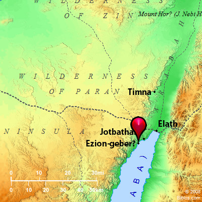
The “promised land” was described to the Israelites as “a land whose stones are iron, and out of whose hills you can dig copper” (Deuteronomy 8:9). Copper was mined in the Arabah of Israel as far back as the 13th-12th century B.C. Copper is still mined at Timna about 25 miles north of Eilat (close to Ezion-geber). Belgian engineers made a survey proving the presence of 100,000 tons of metallic copper. Iron ore has been found in the Negev and in eastern Upper Galilee (Vilnay, The Israel Guide, 17).

The Bible does not say that Solomon had copper mines at Ezion-geber, but the presence of mining facilities dating to the 10th century B.C. indicates that this may have been one of the reasons why the King built a port and had a navy stationed there (1 Kings 9:26-28). Ezion-geber was more than 220 miles from Jerusalem. The copper provided a good medium of exchange for gold, spices, and other items that Israel needed.

These massive pillars at Timna have been associated with Solomon for a long time. Photo by Ferrell Jenkins.

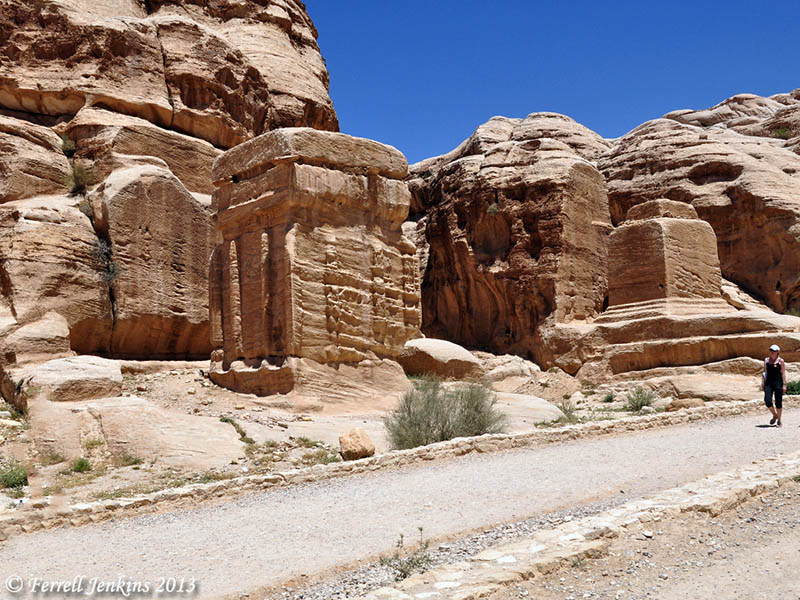
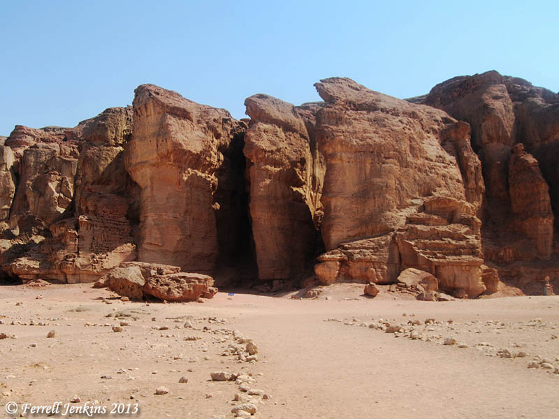
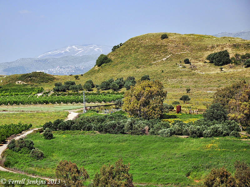
The Pillars of Solomon. These massive pillars at Timna have been associated with Solomon for a long time. Photo by Ferrell Jenkins.

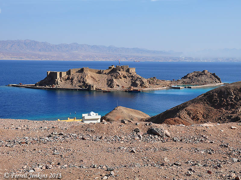
In 1938, Nelson Glueck, reported that he had found a copper-refining plant at Tell el-Kheleifeh, which he identified as Ezion-geber, on the north shore of the Gulf of Aqabah (the Israelis call it the Gulf of Eilat). This site is now within Jordanian territory. Glueck identified the copper-refining plant as King Solomon’s copper mines, and explained that the apertures in the buildings served as flueholes. Through them, he thought, “the strong winds from the north-northwest entered into the furnace rooms of this structure,” which he called a “smelter, to furnish a natural draft to fan the flames.”

It is true that copper smelting was done in the Arabah in the time of Solomon, but Glueck later changed his mind about the building he had formerly identified as the refining plant. In 1962 Beno Rothenberg demonstrated that the installation at Tell el-Kheleifeh could not have been for copper smelting.

Glueck was convinced by the findings of Rothenberg that the apertures in the building “resulted from the decay and or burning of wooden beams laid across the width of the walls for bonding or anchoring purposes.” This does not affect any statement of the Bible, but it does mean that the old argument about the copper refining plant found in the Arabah is no longer valid. Glueck’s identification of Tell el-Kheleifeh with Ezion-geber is no longer accepted. We plan to follow this post with one on Solomon’s seaport.

A recent excavation and study, including archaeometric dating (of Site 30 of the southern Arabah) conducted by Erez Ben-Yosef, et al. has provided a new chronological framework for Iron Age copper production at Timna (Israel). Ben-Yosef says the study,

resulted in a new chronological framework for Iron Age copper production in this region. The main period of copper smelting in the southern Arabah was during the 10th century B.C.E., and the extent of New Kingdom Egyptian control over copper production in Timna was more limited than previously believed. (“A New Chronological Framework for Iron Age Copper Production at Timna (Israel).” BASOR 367 (2012), p. 65.

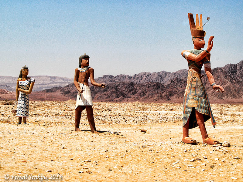
Egyptians welcome visitors to Timna Park. It is true that Egyptians worked in the area during the 13th-12th centuries B.C., but Ben-Yosef says their control over the copper production “was more limited than previously believed.”

Entrance to the Timna Park. Photo by Ferrell Jenkins.

Egyptians welcome visitors to the Timna Park. Perhaps some Israelites should be added. Photo by Ferrell Jenkins.

Other post having to do with copper may be read here, here, and here.

This paragraph provides documentation for some of the material mentioned above. For more information one may check the following books or articles by Nelson Glueck: “The First Campaign at Tell el-Kheleifeh,” Bulletin of the American Schools of Oriental Research, Oct., 1938; The Other Side of the Jordan, 1940; Rivers in the Desert, 1949; the change was announced in “Ezion-geber,” The Biblical Archaeologist, Sept., 1965.

Catching up on the news

For the past few weeks I have been marking items to mention on this blog, but I have gotten behind due to a speaking engagement all last week and some other things. Take a look at those that interest you.

Excavation Reports

James Tabor reports on the 2013 Mt. Zion dig season. The team thinks they may have uncovered a Second Temple period priestly mansion. They found a bathroom with a tub adjecent to a “large below-ground ritual cleansing pool (mikveh) — only the fourth bathroom to be found in Israel from the Second Temple period, with two of the others found in palaces of Herod the Great at Jericho and Masada.” To read more click here.

DK sent me a link to an article in The Huffington Post here. The headline is typical media: “Bathtub Unearthed In Jerusalem May Have Belonged To One Of Jesus’ Enemies.” (Or not!) The first line of the story asks, “Have researchers uncovered the bathtub of one of Jesus’ persecutors?” At least wait until they build a structure over the excavation and begin charging admission. There are several nice photos at the bottom of the article.

Abel Beth Maacah (Abel-Beth-Maacah) is in the north of Israel nearly to the border with Lebanon. Excavations under the direction of Robert Mullins and Nava Panitz-Cohen. The team is looking for Abel’s Aramean (Syrian) connection, and to Phoenician connections. The report reminiscences,

A modern illustration of the proximity of Tel Abel Beth Maacah to the Phoenician coast can be found in an exhibit in the local museum at nearby Metulla. An advertisement from the 1930’s invites one to spend their summer vacation in lovely, cool Metulla. According to the ad, the easiest way to get there from Tel Aviv is to take a boat to Tyre and then a carriage from there to Metulla, 35 kilometers away! We dream of the day when we too can take such a ride.

For our previous posts on Abel Beth Maacah, along with Biblical references, see here, here, and here. The brief excavation report, with numerous photos, is in the The Ancient Near East Today here.

North end of Tell Abel-Beth-Maacah with Mount Hermon to the east. Photo by Ferrell Jenkins.

North end of Tell Abel-Beth-Maacah with Mount Hermon in the background to the east across the Beqa Valley. Photo by Ferrell Jenkins.

The first excavations ever have begun at the ancient city of Derbe. Derbe was visited by Paul and Barnabas on the first preaching journey (Acts 14:20-21). Paul returned with Silas on the second journey (Acts 16:1). We look forward to future reports from Derbe.

See the announcement in Hurriyet Daily News here. HT: HolyLandPhotos Blog.

And More…

The American School of Oriental Research (ASOR Blog) publishes a monthly publication called The Ancient Near East Today. You may sign up for this (currently) free newsletter. In addition to the report on Abel Beth Maacah, I found the illustrated article about “Digging through Data at the Oriental Institute” extremely fascinating. Take a look at the photo of Dr. James H. Breasted breaking ground for the Oriental Institue, and the iconic photo from about 1975 of the famous card catalog and research area. My late friend Dr. James Hodges worked here for several years while completing his doctorate. The article goes on to show the changes wrought by the digital age.

Oriental Institute Research Area about 1975.

Oriental Institute Research Area about 1975.

Leon Mauldin has a good article on “Physical Features of the Land of Israel” here. A helpful map is included with the article. After discussing the geographical features of the land, Leon reminds us,

These factors helped determine where people lived, what crops could be grown where, and what land was good for cattle, etc. No place on earth has as much variety as the Bible land.

On taking yourself too seriously

On the way from Luxor to the Valley of the Kings on the West Bank of the Nile one passes two huge statues known as the Colossi of Memnon. The statues are nearly 60 feet tall, and once stood at the entrance to the funerary temple of Amenhotep III (also known as Amenophis III). With their crowns, each statue would have been about 66 feet tall. Amenhotep III ruled Egypt during the 18th Dynasty (14th century B.C.).

During the time of the Roman Empire the statues were mistakenly associated with “Memnon, son of Eos and Tithonus, who was killed by Achilles during the Trojan War” (Baedeker’s Egypt).

The last time I was in the Valley of the Kings I noticed the head and chest of the statue had become a resting place for birds. Just an interesting picture, I thought.

Statue of Amenhotet III (or Amenophis III) on West Bank of Nile at Thebes (Luxor). Photo by Ferrell Jenkins.

Statue of Amenhotep III (or Amenophis III) on West Bank of Nile at Thebes (Luxor). Photo by Ferrell Jenkins.

Whether covered by sand or birds, this illustrates how the “mighty” are esteemed by many who follow. Don’t take yourself too seriously!

Paul: For by the grace given to me I say to everyone among you not to think of himself more highly than he ought to think, but to think with sober judgment, each according to the measure of faith that God has assigned. (Romans 12:3 ESV)

The Catacombs of Rome have an apologetic value

The catacombs of Rome are the main sources of art by Christians in the 2nd and 3rd centuries A.D.

Markers often carry the image of a shepherd, lamb, anchor, fish, or some other symbol. The fish or the word fish was used to indicate a Christian or a place where Christians met in those days. The Greek word for fish is Ichthus. When used as an acrostic with each letter standing for a word or phrase the word means, Jesus Christ, God’s Son, the Savior.

It is estimated that as many as one hundred thousand inscriptions were carved on the walls of the catacombs. About 15,000 have been discovered. The pictures often combine a biblical theme with a heathen figure. The late R. C. Foster comments on this phenomenon :

But the very fact that the catacomb pictures are filled with heathen figures and conceptions intermingled with the Christian, shows that the simple faith had already begun to be corrupted, and that too much weight can not be attached to pictures which combine the Good Shepherd with flying genii, heads of the seasons, doves, peacocks, vases, fruits, and flowers.

Marker in one of the catacombs. Note symbols of anchor and fish. Photo by Ferrell Jenkins, 1973.

Marker in one of the catacombs. Note symbols of an anchor and fish. Photo by Ferrell Jenkins, 1973. Digitized from a slide.

Foster shows that there is an apologetic value to the catacomb inscriptions.

Although their faith, as witnessed on the walls of the catacombs, was imperfect, and at times confused, the modernists will have to chisel off these pathetic and challenging inscriptions before they can ever convince the world that Jesus of Nazareth is a myth (R. C. Foster, Introduction and Early Ministry, 29-32).

Fish, anchor, and Chi Ro symbols. Photo by Ferrell Jenkins, 1975.

Anchor, fish, and Chi Rho symbols. Slide Photo by Ferrell Jenkins, 1975.

Roman period wine presses at Eretz Israel Museum

The Eretz Israel Museum, located on the campus of Tel Aviv University in Tel Aviv, is a wonderful, educational museum to visit. Many of the exhibits are outside, including an archaeological tel (Tel Qasile), and others are in several different small buildings.

In the photo below we see two Roman period wine presses. (Common English versions use the spelling winepress.) The treading floors are on the left and the collecting vats are on the right.

Roman winepresses at Eretz Israel Museum, Tel Aviv. Photo by Ferrell Jenkins.

Roman wine presses at Eretz Israel Museum, Tel Aviv. Photo by Ferrell Jenkins.

The sign below provides needed explanation for those who have not seen a wine press from the Roman period.

Explanation of Roman winepresses at Eretz Israel Museum, Tel Aviv. Photo by Ferrell Jenkins.

Explanation of the Roman wine presses at Eretz Israel Museum. Photo: Ferrell Jenkins.

One of the parables of Jesus illustrates how common such wine presses were in Biblical times.

“Hear another parable. There was a master of a house who planted a vineyard and put a fence around it and dug a winepress in it and built a tower and leased it to tenants, and went into another country. (Matthew 21:33 ESV)

See a photo of the Byzantine wine press at Avdat here. The Museum website may be visited here.

Tel Rekhesh may be Anaharath

The Jewish Press reported here on the discovery of a Canaanite cult altar at Tel Rekhesh, an archaeological mound east of Mount Tabor. Archaeologists from the University of Tenri, Japan, and the Institute of Archaeology of Galilee Kinneret Academic College, have been working together at the site for the past six years. I have had the site on my “wish list” for the past three years, but have not yet visited the it.

The reports says,

The same excavations also revealed large parts of a Jewish farmhouse dating back to the Second Temple. Researchers were able to establish that this was a place of Jewish dwellers based on typical stone tools, oil lamps and coins minted in the city of Tiberias.

“The diggers received a big surprise,” said Chairman of the Institute of Archaeology of Galilee Kinneret Academic College Dr. Mrdechai [Mordechai] Avi’am. “In the ruins of the second floor of the farmhouse, they discovered a Canaanite cult statue, similar to a statue that stood in the sanctuary of a temple which is yet to be located.”

“Similar stones have been discovered in a number of Canaanite sites, such as Hazor,” Dr. Avi’am said. “The same stone was later used as part of a doorframe in one of the rooms of the Jewish structure. This is the unique development of archaeological hills in Israel, where successive generations mingle ritual objects on their way from the world of the Canaanite mythology to monotheism.”

This region is located in the territory allotted to the tribe of Issachar (Joshua 19:17-23). Y. Aharoni identified Tel Rekhesh with the Biblical site of Anaharath (Joshua 19:19).

Location of Anaharath. BibleAtlas.org.

Location of Anaharath. BibleAtlas.org.

In a page About the Site, the web page says,

Some of the findings from the site, collected by local people, are now exhibited in the archaeological museum in the Kibbutz Ein-Dor, some 5 km from Tel Rekhesh.  The collection includes a fragment of Egyptian stela, a clay model of a temple, and complete pottery from various periods.

The photo below is one I made earlier this year. At least seven of the artifacts displayed in this case are identified as being from Tel Rekhesh. Most of them are used in food preparation. The shrine in the center (“model of a temple”) is a replica. I failed to get a photo of the Egyptian stela fragment.

At least 7 of the artifacts displayed in this case at The Ein Dor Archaeological Museum are from Tel Rekesh. Photo by Ferrell Jenkins.

At least 7 of the artifacts displayed in this case at The Ein Dor [En-dor, Endor] Archaeological Museum are from Tel Rekesh. Photo by Ferrell Jenkins. Click to enlarge.

The web site for the Tel Rekhesh project is available here, but the content is not current. Todd Bolen includes a photo of Tel Rekhesh in the Tabor River valley here.

HT: Joseph I. Lauer

Herod the Great: The King’s Final Journey

The Israel Museum exhibition of Herod the Great: The King’s Final Journey is scheduled to continue through January 4, 2014. This is a wonderful exhibit. If you can’t make it by the deadline, you may take a gallery tour here. This includes photos, drawings, explanations, and videos that walk you through the exhibit.

Entrance to the Herod the Great exhibit in the Israel Museum. Photo by Ferrell Jenkins.

Entrance to the Herod the Great exhibit in the Israel Museum.

For additional information about Herod and some of his building projects, see here, herehere, and other places.

Leen Ritmeyer was with a group allowed to make some photos within the exhibit. Read about it here.