Tag Archives: Syria

Visualizing Isaiah 9: the Philistines on the west

Isaiah 9 contains several geographical references. I decided to concentrate on the reference to the Philistines in verse 12. Notice that the text mentions the Syrians (Arameans) on the east, literally northeast of Israel and Judah, and the Philistines on the west (literally the southwest).

“The Syrians on the east and the Philistines on the west devour Israel with open mouth. For all this his anger has not turned away, and his hand is stretched out still.” (Isaiah 9:12 ESV)

Both powers were perennial enemies of Israel. Both would take part in attacks on Israel. The Philistines also are mentioned in 2:6 and 11:14.

It is commonly understoos that the Philistines of the Old Testament were the Sea People. The five major cities of the Philistines were Ashdod, Gaza, Ashkelon, Gath, and Ekron (1 Samuel 6:17).

A row of signs at the entry to Tel Ashkelon picture some of the peoples who lived there. This sign represents the Philistines. Photo by Ferrell Jenkins.

A row of signs at the entry to Tel Ashkelon picture some of the people who lived there. This sign represents the Philistines. Photo by Ferrell Jenkins.

The temple of Medinet Habu is located near the Colossi of Memnon at Thebes (Luxor), Egypt. The temple was built during the reign of Rameses III (reigned 1186–1155 B.C.). The structures at the site were built by the Pharaoh to serve as an administrative complex and funerary temple. The most interesting aspects of the temple to me are the reliefs of the Sea Peoples that the king claims to have subjugated. Notice that some of these men are bound.

This is a portion of a wall at Medinet Habu showing the subjugation of the Sea People by Ramses III. Photo by Ferrell Jenkins.

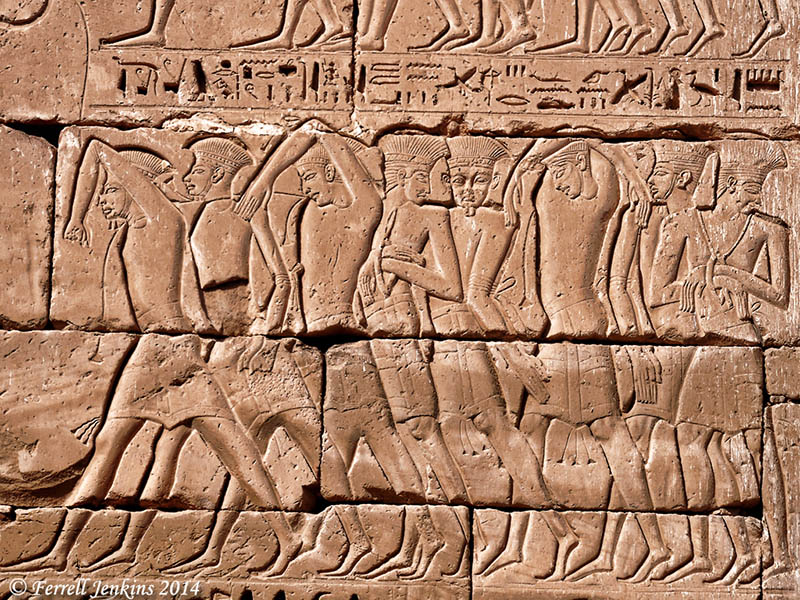
A portion of a wall at Medinet Habu shows the subjugation of the Sea People by Ramses III. Notice the distinctive feathered hats and animal skin skirts. Photo by Ferrell Jenkins.

These peoples might seem more powerful than Israel at the moment, but the LORD will punish them. Both Damascus and the Philistines fell to the Assyrians within a few years.

The LORD continued to remind Israel and Judah that He was willing to save them from the coming oppression:

For all this his anger has not turned away, and his hand is stretched out still. (Isaiah 9:21 ESV)

Hiking Abraham’s footsteps

The full title of this Haaretz article is “Hiking in Abraham’s footsteps, from Turkey to the Holy Land.” Sounds incredible at the moment. To hike this complete trail from Haran (Genesis 12:4) to Beersheba (Genesis 21:31) (not to mention the trip to Egypt) requires travel in Turkey, Syria, Jordan, Israel, and the Palestinian Authority (West Bank).

Among the leaders back of the concept is David Landis and his wife Anna Dintaman, developers of the Jesus Trail from Nazareth to the Sea of Galilee. Their book, Hiking the Jesus Trail and Other Biblical Walks in the Galilee, is worthwhile even for those who do not plan to walk the trail.

Larry Haverstock walked the Jesus Trail in 2011. I see that Larry’s posts about the experience is still available on his blog. See the 3rd Journey. You will find some fascinating stories along with beautiful photos you may never see from a bus or car.

Larry Haverstock in the Zippori Forest north of Nazareth.

Larry Haverstock in the Zippori Forest north of Nazareth.

The link to the Haaretz article may be accessed here. In order to read the full article you must register for free access to 10 articles a month.

Don’t expect to walk the Abraham Path from Haran (in Turkey) to Beersheva [Beersheba], but you might be able to walk small portions of the trail everywhere except the part going through Syria.

There are many hiking trails in Israel, but most of these avoid contact with the Palestinian Authority. The new plan seeks to involve the local people in the development of facilities useful to hikers.

If you like hiking, or if you appreciate the geography of the Bible lands you will probably enjoy the article. Abraham Path has a nice web site with maps and photos here.

I don’t know what, if any, relationship there is between the Abraham  Path and the Patriarchs Way, a trail that is said to run from Beersheba to Nazareth. The defacing of the sign to eradicate the Arabic indicates one of the problems either trail might face. One often sees this sort of thing on signs pointing to Christian sites.

Sign pointing to Patriarchs Way off Hebron Road (Hwy. 60) south of Bethlehem . Photo by Ferrell Jenkins.

Sign pointing to Patriarchs Way off Hebron Road (Hwy. 60) south of Bethlehem . Photo by Ferrell Jenkins.

Walk the Land : A Journey on Foot through Israel, by Judith Galblum Pex, is a fascinating account of a couple who walked the Israel Trail from Eilat to Dan.

Damage Reported at Mari in Syria

The French archaeologist André Parrot (1901-1980) carried out several excavations at Mari between 1933 and 1960. Having read about recent damage to the ancient buildings of Mari, I wanted to share a couple of photos of artifacts from the site.

The first statue is of the Iku-Shamagan, King of Mari. It dates to about 2650 B.C. and is from the temple of Ishtar in Mari. The statue is about 47 inches high and was displayed in the Damascus Museum in 2002 when I made this photograph.

King of Mari statue in Damascus Museum. Photo by Ferrell Jenkins 2002.

Iku-Shamagan, King of Mari, praying. Statue in Damascus Museum. Photo by Ferrell Jenkins 2002.

The small (about 20 inches high) statue of Ebih-II, the superintendent of Mari, was discovered in the temple of Ishtar. It dates to the period of about 2900-2750 B.C. and is made of gypsum, with eyes of shells and lapis lazuil. This artifact, along with several others, is displayed in the Louvre.

Attendant to Ebih II of Mari. Louvre. Photo by Ferrell Jenkins.

Statue of Ebih II superintendent of Mari. Louvre. Photo by Ferrell Jenkins.

Mari is located far east in Syria near the Euphrates River. The city was located on the main route between Assyria and Babylon. If Abraham first lived in south Mesopotamia then he might have passed this way on the trip to Haran (Genesis 11:27 – 12:5).

Project Syrian Archaeology has some photos of poor quality showing damage to historical sites at their Facebook page here.

Excitement at Carchemish

It must have been exciting to be at Carchemish in 605 B.C. when Pharaoh Neco came all the way from Egypt to this city now on the border between Syria and Turkey. On an earlier excursion from Egypt to Carchemish in 609 B.C., Neco killed Josiah, king of Judah, at Megiddo.

Pharaoh Neco came to assist the Assyrians as they fought the Babylonians. But the emerging world power from the southern Euphrates city of Babylon overpowered the Assyrians and the Egyptians and sent Neco running back to Egypt. Nebuchadnezzar, king of Babylon, chased Neco to the border of Egypt.

It is still exciting at Carchemish. I have been within sight of Carchemish once. The military installations were clearly visible on top of the tell. The tour operator handling my tour in Turkey a previous time advised me not to go to Carchemish (Karkamis) because it is “zero on the border” of Turkey and Syria.

Carchemish with a Turkish military base on top. Photo by Ferrell Jenkins 2007.

Carchemish with a Turkish military base on top. Photo by Ferrell Jenkins 2007.

We were excited to learn that new excavations had begun at Carchemish. That was before the recent “uncivil war” in Syria. Now, two reports give a little glimpse into the archaeological work there.

The first report from the WorldBulletin reports:

What could be the largest discovered inscribed tablet (stele), dating to the reign of Babylonian king Nebuchadnezzar II between 605-562 BC, has been discovered in the Turkish city of Karkamis on the military zone along the Turkey-Syria border.

Noting that the excavations sites are untroubled despite their proximity to the Syrian civil war, Dr. Nicola Marchetti said the Karkamis archeological museum is scheduled to open next year.

“Excavations are right on a military zone with 55 hectares in Turkey and 35 in Syria,” said Marchetti, the head of the Turkish and Italian excavation teams, at a press conference held in the Assembly Hall of the Metropolitan Municipality.

Excavations this year also unearthed a cuneiform tablet at the palace of Carchemish king Katuwa dating to 800 BC, as well as over 300 sculptures, a Luwian hieroglyphic inscription and a mosaic.

Read the full report here. I assume the work described in this report is somewhere other than the top of the high mound.

A report from ANSAmed used a few more words about the stele dating to the reign of Nebuchadnezzar.

Marchetti is proudest of a stele, or commemorative slab, carved with the face of Babylonian King Nebuchadnezzar, the conqueror of Karkemish. He destroyed Jerusalem and the Temple of Salomon in 587 BC, and built the Hanging Gardens of Babylon, which were the seventh wonder of the ancient world.

”It’s a beautiful, compact piece of limestone”, Marchetti enthuses of this unique, historic find.

This report may be read here. It continues to tell about some recent al-Qaeda activity near the border in Syria affected by the excavation.

While it’s an almost peaceful cohabitation, it is also true that the dig is within a Turkish military base. This offers the Italians a relative sense of safety – except on September 3, when al-Qaeda attacked the Syrian town of Jarabulus, eventually wresting it from the ”official” anti-Assad Free Syrian Army (FSA) insurgents. ”It was hell on earth. Bullets were flying everywhere”, says Marchetti, who teaches Near Eastern archeology at Bologna University.

”Luckily, archeologists dig holes. We dove in. We kept digging inside the deeper ones. The Turkish military kept telling us, stay down”. Calm was restored once the FSA fighters gave themselves up to the Turks in order to flee al-Qaeda. An armed truce has held since, allowing the Italian team to unearth new treasures.

Now we know why archaeologists dig trenches and holes.

I look forward to seeing that new archaeological museum at Karkamis. Karkamis is a small town of less than 5000 population.

HT: Jack Sasson

Looting and vandalism in Petra

Looting and vandalism of historic or archaeological sites is nothing new. We have reported on vandalism in Israel, but especially in the war-torn countries of Syria and Iraq.

Heritage Daily has an article here on looting and vandalism at Petra. Petra was designated a UNESCO World Heritage Site in 1985. Archaeologists from Brown University have been working in Petra since 2009. They have been able to photograph excavated area each year. Now they report on signs of recent vandalism. The article says,

The damage caused by looting is nothing new and some of the more iconic buildings at Petra bear witness to this. A giant urn carved above the entrance to the Monastery bears the marks of hundreds of gunshots. The local Bedouin tribesmen living in and among the ancient ruins say the damage was caused when local men would open fire with rifles, seeking the loot thought to be inside the urn which is actually made of solid stone.

Heritage Daily has established from sources at Brown University that they are lobbing for additional security at the site and robust investigation to target the individuals concerned. However lack of funds for the Petra Archaeological Park and the isolated rugged area is hindering this work.

There is a considerable amount of natural wear over the centuries. In some cases we must imagine how the stones looked when they were carved by the Nabateans who lived in the area.

Nabatean Djinn blocks at Petra. Photo by Ferrell Jenkins.

Nabatean Djinn blocks at Petra. Some sources refer to these as god-blocks.Photo by Ferrell Jenkins.

I have noticed erosion in the structures cut from the beautiful sandstone at Petra since my first visit in 1967. Some of this may have been caused by those who fill little bottles with the various colors of sand to sell to the tourists.

Natural erosion is evidence in these structures cut from the beautiful sandstone structures of Petra. Photo by Ferrell Jenkins.

Natural erosion is evidenced in these structures cut from the beautiful sandstone structures of Petra. Photo by Ferrell Jenkins.

This territory was once inhabited by the Biblical Edomites, but the structures we see today were carved from stone by the Nabateans who inhabited the area from about the fourth century B.C. to the early second century A.D.

One of the most famous Nabatean rulers was Aretas IV (about 9 B.C. to A.D. 40). It was during his reign, which extended at far north as Damascus, when Paul escaped Damascus (2 Corinthians 11:32-33). See here.

HT: Jack Sasson

Catching up on the news

For the past few weeks I have been marking items to mention on this blog, but I have gotten behind due to a speaking engagement all last week and some other things. Take a look at those that interest you.

Excavation Reports

James Tabor reports on the 2013 Mt. Zion dig season. The team thinks they may have uncovered a Second Temple period priestly mansion. They found a bathroom with a tub adjecent to a “large below-ground ritual cleansing pool (mikveh) — only the fourth bathroom to be found in Israel from the Second Temple period, with two of the others found in palaces of Herod the Great at Jericho and Masada.” To read more click here.

DK sent me a link to an article in The Huffington Post here. The headline is typical media: “Bathtub Unearthed In Jerusalem May Have Belonged To One Of Jesus’ Enemies.” (Or not!) The first line of the story asks, “Have researchers uncovered the bathtub of one of Jesus’ persecutors?” At least wait until they build a structure over the excavation and begin charging admission. There are several nice photos at the bottom of the article.

Abel Beth Maacah (Abel-Beth-Maacah) is in the north of Israel nearly to the border with Lebanon. Excavations under the direction of Robert Mullins and Nava Panitz-Cohen. The team is looking for Abel’s Aramean (Syrian) connection, and to Phoenician connections. The report reminiscences,

A modern illustration of the proximity of Tel Abel Beth Maacah to the Phoenician coast can be found in an exhibit in the local museum at nearby Metulla. An advertisement from the 1930’s invites one to spend their summer vacation in lovely, cool Metulla. According to the ad, the easiest way to get there from Tel Aviv is to take a boat to Tyre and then a carriage from there to Metulla, 35 kilometers away! We dream of the day when we too can take such a ride.

For our previous posts on Abel Beth Maacah, along with Biblical references, see here, here, and here. The brief excavation report, with numerous photos, is in the The Ancient Near East Today here.

North end of Tell Abel-Beth-Maacah with Mount Hermon to the east. Photo by Ferrell Jenkins.

North end of Tell Abel-Beth-Maacah with Mount Hermon in the background to the east across the Beqa Valley. Photo by Ferrell Jenkins.

The first excavations ever have begun at the ancient city of Derbe. Derbe was visited by Paul and Barnabas on the first preaching journey (Acts 14:20-21). Paul returned with Silas on the second journey (Acts 16:1). We look forward to future reports from Derbe.

See the announcement in Hurriyet Daily News here. HT: HolyLandPhotos Blog.

And More…

The American School of Oriental Research (ASOR Blog) publishes a monthly publication called The Ancient Near East Today. You may sign up for this (currently) free newsletter. In addition to the report on Abel Beth Maacah, I found the illustrated article about “Digging through Data at the Oriental Institute” extremely fascinating. Take a look at the photo of Dr. James H. Breasted breaking ground for the Oriental Institue, and the iconic photo from about 1975 of the famous card catalog and research area. My late friend Dr. James Hodges worked here for several years while completing his doctorate. The article goes on to show the changes wrought by the digital age.

Oriental Institute Research Area about 1975.

Oriental Institute Research Area about 1975.

Leon Mauldin has a good article on “Physical Features of the Land of Israel” here. A helpful map is included with the article. After discussing the geographical features of the land, Leon reminds us,

These factors helped determine where people lived, what crops could be grown where, and what land was good for cattle, etc. No place on earth has as much variety as the Bible land.

Ninth century B.C. chalices uncovered at Gath

A few chalices dating to the time of the destruction of the Philistine city of Gath by Hazael, king of Aram (Syria), have been announced during the current excavation at Tel es-Safi/Gath. The most recent, larger than usual, chalice was announced by Prof. Aren Maeir on Monday and Tuesday. Follow the excavation reports here.

Jar and chalice in Area D at Tel es-Safi/Gath. Photo: Tell es-Safi/Gath Archeological Project.

Jar and chalice (upside down beside the balk) in Area D at Tel es-Safi/Gath. Photo: Tell es-Safi/Gath Archeological Project.

Prof. Maeir displays the large chalice after the stand was excavated. (I like the T-shirt. Maybe there is another step down — a human stooped over with a mobile phone.)

Prof. Aren Maeir displays the large chalice uncovered this week at Tel es-Safi/Gath. Jar and chalice in Area D at Tel es-Safi/Gath. Photo: Tell es-Safi/Gath Archeological Project.

Prof. Aren Maeir displays the large chalice uncovered this week at Tel es-Safi/Gath. Jar and chalice in Area D at Tel es-Safi/Gath. Photo: Tell es-Safi/Gath Archeological Project.

Vessels of this type were sometimes used for burning incense.

Gath was one of five cities of the Philistine Pentapolis (1 Samuel 6:17). The city was destroyed by the Aramean King Hazael shortly after the middle of the 9th century B.C.

At that time Hazael king of Syria went up and fought against Gath and took it. But when Hazael set his face to go up against Jerusalem, (2 Kings 12:17 ESV)

Joseph Lauer calls attention to a nice article about the find in The Jerusalem Post here. The author of the article is Joshua Lipson. Joshua volunteered at the Tel es-Safi/Gath excavation a few years ago.

And thanks to Prof. Maeir for posting the nice photos. No good reason to hide discoveries like this.

Following the news in the Bible World

Beginning with the Six Day War (June 5-10, 1967) I have tried to keep alert to the situation in the countries that are often called the Bible lands or the Bible World. This phrase is given to the countries of Iran, Iraq, Turkey, Syria, Lebanon, Jordan, Israel, Egypt, Greece, et al. where the events of the Bible transpired. Over the past 47 years I have traveled in all of these countries, some extensively, except Iran.

The current news coming out of Egypt is not good, and it is sad to see the conditions there. I wish for peace and justice for the people of Egypt, and the other countries mentioned above. I wish it also for those who would like to travel to these ancient lands to better learn the history, both secular and biblical.

A scene on the Nile River in Upper Egypt. Photo by Ferrell Jenkins.

A scene on the Nile River in Upper Egypt. Photo by Ferrell Jenkins.

The photo above was made from the Nile River in Upper Egypt, near the ancient town of Edfu. When I look at it I am reminded of the Genesis account of the seven lean cows and seven plump cows that Joseph saw coming up out of the Nile (Genesis 41).

Syrian archaeological site endangered — a look at Ebla

During the course of the bloody civil war in Syria we have heard of damage to various archaeological sites such as Aleppo and Palmyra. A recent article in The New York Times here includes a report specific to Tell Mardikh in northern Syria, about 30 miles SW of Aleppo.

The headline tells the story, “Grave Robbers and War Steal Syria’s History.” An excellent video illustrates what both of these factors (vandalism and war) are doing to destroy the ancient site.

Tell Mardikh, ancient Ebla, and one of the tablets discovered in 1975. Photo by Ferrell Jenkins.

Tell Mardikh, ancient Ebla, and one of the tablets discovered in 1975. Photo by Ferrell Jenkins.

We have previously written about Ebla, and the Ebla tablets, here, and here.

More than 17,000 cuneiform tablets were discovered in 1975. They date to the mid-third millennium B.C. when Ebla was the capital of a great Canaanite empire. Scholars state that there are important affinities between the Eblaite language and biblical Hebrew, both being members of the Northwest Semitic family.

The first golden age of Ebla is dated to 2400–2250 B.C. This is long before the time of Abraham who lived north of Ebla at Haran in Padan Aram for a time. Haran is about 150 miles north of Ebla.

So Abram went, as the LORD had told him, and Lot went with him. Abram was seventy-five years old when he departed from Haran.  (Genesis 12:4 ESV)

The death and destruction that has been going on in Syria is almost beyond comprehension. When we destroy our ancient history we become what Elton Trueblood called the Hippie generation, “a cut-flower generation.”

Horses in the Golan Heights

Last September we stopped in the Golan Heights at the overlook east to Kuneitra, Syria. A few horses were being pastured in the area. Mount Hermon is visible to the north.

Horses in the Golan Heights. Mount Hermon in the distance. Photo by Ferrell Jenkins.

Horses in the Golan Heights. Mount Hermon in the distance. Photo by Ferrell Jenkins.

This area is included in the description of the victories of the Israelites.

Now these are the kings of the land whom the people of Israel defeated and took possession of their land beyond the Jordan toward the sunrise, from the Valley of the Arnon to Mount Hermon, with all the Arabah eastward: (Joshua 12:1 ESV)