If we consider the Gospel of John a sort of “Day Planner” for Jesus, we have nearly complete activity recorded for two weeks of the earthly ministry of Jesus. The first is in John 1:19—2:11 where activity for six of the seven days is recorded. I think the omitted day is the sabbath.
The next nearly complete week is the last week, leading up to the resurrection. John gives more attention to the last week than any other Gospel. Even here we have activities for only six of eight days. This section begins in John 12:1 and continues into John 20. Here is the way I have reconstructed it. Where John does not record the activity I have omitted the scripture reference.
Sunday — The King enters Jerusalem — 12:12-19
Monday — Cleansing the Temple —
Tuesday — Visit of the Greeks — 12:20-36
Tuesday — Jewish rejection — 12:37-50
Wednesday — No events recorded in the Gospels
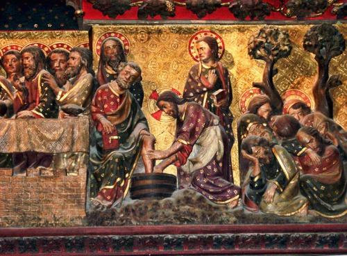
Thursday Evening — Passover Meal, including Washing Disciples Feet (only in John) — 13:1-38
Thur. Eve — Farewell discourses — 14—16
Thur. Eve — Prayer — 17
Thur. Eve — Annas (only in John) — 18:12-14
Thur. Eve — Caiaphas — 18:24-28
Friday — Pilate — 18:28—19:16
Friday — Crucifixion — 19:16-42
Sabbath —
First Day — Resurrection — 20
It should be noted that the appearance before Annas and Caiaphas were the Jewish (Religious) trials. The appearance before Pilate [and Herod Antipas] were the Roman (Civil) trials.
John does not record the pronouncement of woes on the religious leaders, the institution of the Lord’s Supper, and the account of the agony in the Garden of Gethsemane.
With this sparse attention given to two weeks, no wonder John says,
Now there are also many other things that Jesus did. Were every one of them to be written, I suppose that the world itself could not contain the books that would be written. (John 21:25 ESV)
There is a medieval wood carving of the last week of Jesus in Notre Dame (Paris). In this photo you see the representation of the last supper, the washing of the disciples’ feet, and the agony in Gethsemane. (Sorry, this was made more than a decade ago and I don’t have a hi-res photo.) I do not know if this was destroyed in the fire.
Wood carving of Last Week of Jesus in Notre Dame. I do not know if this was destroyed in the fire. Photo by Ferrell Jenkins.
A reader of the previous post (Click to read: https://wp.me/p1zOp-5FC ) wonders how we know Jerusalem was not destroyed later than A.D. 70.
It is a good question. The New Testament, including the records of the life and ministry of Christ, is rooted in history. Notice how Luke, a gentile physician, emphasizes the historicity of the work of John the Baptist and the beginning of the baptism and ministry of Jesus.
Luke 3:1 In the fifteenth year of the reign of Tiberius Caesar, Pontius Pilate being governor of Judea, and Herod being tetrarch of Galilee, and his brother Philip tetrarch of the region of Ituraea and Trachonitis, and Lysanias tetrarch of Abilene, 2 during the high priesthood of Annas and Caiaphas, the word of God came to John the son of Zechariah in the wilderness. 3 And he went into all the region around the Jordan, proclaiming a baptism of repentance for the forgiveness of sins. (Lk. 3:1-3 ESV)
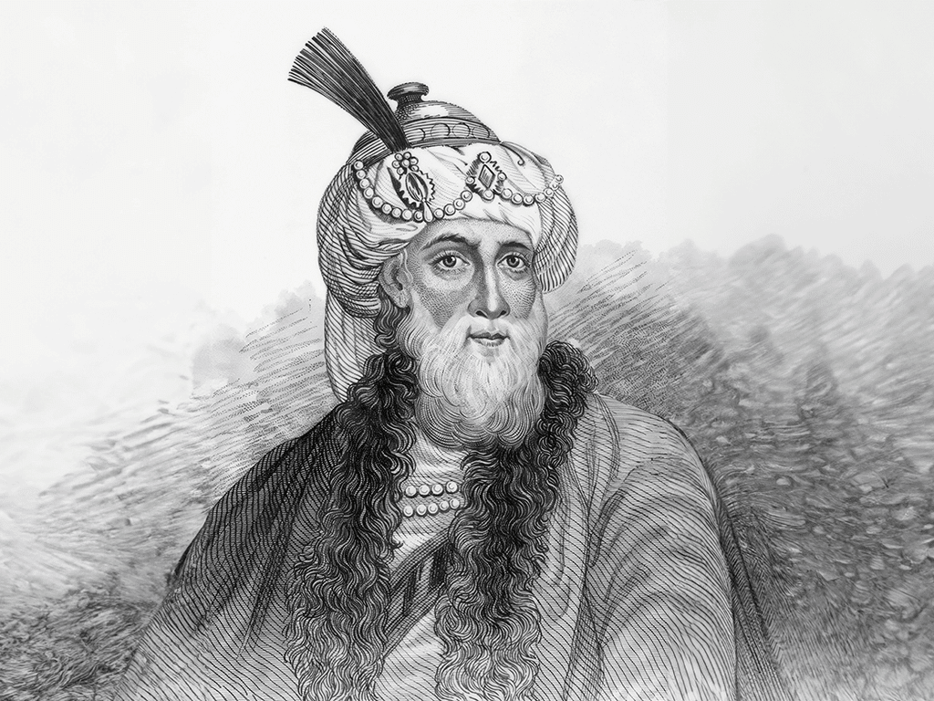
We don’t know what Josephus looked like, but older English versions of his works sometimes included a line drawing. David Padfield, at Padfield.com, had one of those old drawings enhanced by AI and shared the drawing with me. I suggest you visit Padfield.com for more good material.
Josephus, the Jewish historian, who was contemporaneous with these events, and an eye witness of many of them, tells us much about the movement of the Romans as they came near the city of Jerusalem. Vespasian had been leading the plans to attack Jerusalem. When he learned of the death of Emperor Nero (A.D. 68) he returned to Rome to become emperor. His son Titus became the leader of the effort. Josephus, a native of Yodfat, now in north western Israel, was an eye witness to many of the events of the Roman invasion of the country. Not only did he write the History of the Jews, but also the Wars of the Jews. He provides specific information about the movement of the Romans as they approached the city of Jerusalem. As the army began to be seen in plain view, Josephus records the events.
JOE Wars of the Jews 2:528: He then pitched his camp upon the elevation called Scopus [or watch tower], which was about a mile from the city; yet did not he assault them in three days’ time, out of expectation that those within might perhaps yield a little; and in the meantime he sent out a great many of his soldiers into neighboring villages, to seize their grain; and on the fourth day, which was the thirtieth of the month Hyperbereteus, [Tisri], when he had put his army in array, he brought it into the city. (Wars 2:528) This might be a reference to the temple which was in the city.
Accordingly, this place, on the north quarter of the city, and joining thereto, was a plain, and very properly named Scopus [the prospect]; 68 and was no more than a mile from the city And here it was that Titus ordered a camp to be fortified for two legions that were to be together; but ordered another camp to be fortified, six hundred yards behind them, for the fifth legion; for he thought that, by marching in the night, they might be tired, and might deserve to be covered from the enemy, and with less fear might fortify themselves; (Wars 5:67-68)
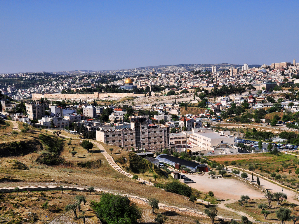
The photo below shows a view of the Old City of Jerusalem made from the slope of Mount Scopus. Notice the Dome of the Rock, the gold domed building with the sun shining on it. It is located approximately where Herod’s temple was stood from its completion until the destruction in A.D. 70. If you click on the image it should enlarge to allow you to see everything better.
(c)FerrelllJenkins2013______________
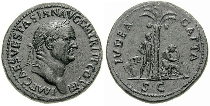
The images below show an example of the coins minted by Vespasian and Titus to commemorate the capture of Judea. The obverse [heads] shows a laureate head of image of Caesar Vespasian. The reverse[tails ] had the wording Judea Capta and shows a mourning Jewess under a palm tree. David Hendin, Guide to Biblical Coins, Fifth Edition, shows a variety of this coin minted by different emperors at various places.
Merrill C. Tenney, New Testament Times, includes a chart of the various Roman and Herodian rulers in connection with the events in Judea. Good Bible dictionaries and Encyclopedias will also provide this type of information.
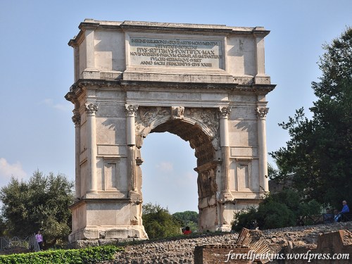
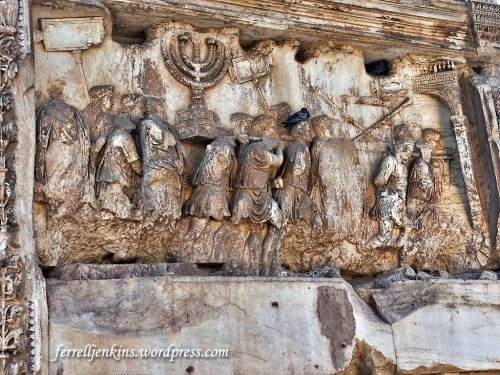
During A.D. 68 and 69 three men, Galba, Otho, and Vitellius, ruled. Vespasian was Emperor of Rome A.D. 69-79. Titus was emperor 79-81. The Arch of Titus on one end of the Roman forum commemorates this event. Carvings on the inside of the arch show the Roman soldiers taking away the ark of the covenant and the table of showbread from the Jerusalem temple.
The Arch of Titus in the Roman Forum commemorates the Roman victory of the Jews in A.D. 70. Photo by Ferrell Jenkins.Arch of Titus relief showing Roman soldiers carrying the items taken from the Temple in Jerusalem in A.D. 70. Photo by Ferrell Jenkins.
Jews now celebrate a holiday called Tisha B’Av [The 9th of the Jewish month of Av] (roughly our August). Tjhis day commemorates the destruction of the first temple which was built by Solomon was destroyed by the Babylonians in 586 B.C., and the destruction of the temple built by Herod the Great was destroyed by the Romans on Tisha B’av in A.D. 70.
Jerusalem was destroyed in A.D. 70, or as the Jews would say 70 C.E..
The modern country of Syria has been often in the news in the past few months and years. In Biblical times Syria had contacts with Biblical Israel. When I requested all forms of Bible references to Syria In the English Standard Version I found 133 matches in in 114 verses. Only nine of these are in the New Testament. We might find additional verses if we searched for various towns or regions of Syria such as Damascus, Hamath or Riblah we would have more. ccc
Because of the significance of Syria in Biblical times, I included the region in some of my tours.
I had the pleasure of visiting Syria several times since the first visit in 1967.During the early years of leading groups to the Bible Lands the tours were longer than those now. The first tour was April 24-May 9, 1967. On that tour my group of 19 visited Rome, Cairo, Beirut, Amman, Jerusalem in Jordan, and made a crossing at Mandelbaum Gate as the place of crossing was known, into Israel. While in Jerusalem, Jordan, we made a trip to Petra in one day. On the final days of the tour we visited Athens and Corinth in Greece before returning to the USA.
Incidentally, as a matter of interest to those who now pay five or six thousand dollars for a tour of seven to ten days That tour of 16 days cost $963.00 from New York. This included a room with bath, and three meals a day. Some hotels had rooms with a shower somewhere along the hall that had to be shared by several visitors.
On Monday, May 1, 1967, our group made a day trip from Beirut to Baalbek, Lebanon and Damascus, Syria.
The street called Straight in Damascus, Syria. Photo by Ferrell Jenkins on one of his visits to Damascus in the late 1960s or early 1970s.
From that time, almost annually we visited Damascus until about 1974. In a 1976 brochure there is this warning:
SPECIAL NOTICE: Political conditions in Lebanon have made it unsafe for tourists during the Summer and Fall of 1975. If conditions are not safe at the time of our tour, we have an alternate plan which wisely uses the time in Cairo, Damascus and Jerusalem.
My recollection is that no other tour included Damascus.
In May, 2002 David McClister, one of my colleagues at Florida College, and I spent three weeks traveling in Lebanon, Syria and Jordan. The time was about equally divided between the three countries. We covered Syria by traveling along the southern border adjoining Lebanon, then we went north as far as possible along the Mediterranean. We turned East and visited places such as Ebla before going north to Aleppo. From there we visited sites to the north including the Euphrates River. This was near the Turkish border and Carchemish.
After that we returned to Damascus for a few days and then we traveled in Jordan for a week.
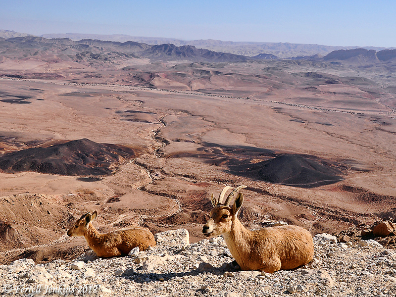
Ibex enjoy the view at Mitzpe Ramon, Israel, in the Wilderness of Zin. These two Ibex are lying on the edge of a steep cliff over a major highway below. Use the blog Search box to locate more photos of Ibex and additional information. Photo by Ferrell Jenkins.
Ibex enjoy the view at Mitzpe Ramon in the Wilderness of Zin. Photo by Ferrell Jenkins
Every time I think of working on tax preparation I think about this episode from the ministry of Jesus:
24 When they came to Capernaum, the collectors of the two-drachma tax went up to Peter and said, “Does your teacher not pay the tax?” 25 He said, “Yes.” And when he came into the house, Jesus spoke to him first, saying, “What do you think, Simon? From whom do kings of the earth take toll or tax? From their sons or from others?” 26 And when he said, “From others,” Jesus said to him, “Then the sons are free. 27 However, not to give offense to them, go to the sea and cast a hook and take the first fish that comes up, and when you open its mouth you will find a shekel. Take that and give it to them for me and for yourself.” (Matthew 17:24-27 ESV).
Fishing is still important on the Sea of Galilee. Tour groups to Israel usually have at at least one meal of the famous St. Peter’s Fish when we are in the Galilee.
Mendel Nun spent more than 50 years fishing the Sea of Galilee. He became an expert in the history of fishing on the Sea. His article, “Cast Your Net Upon the Waters: Fish and fishermen in Jesus’ Time” (Biblical Archaeology Review, 19:06), includes information on this episode. Because this is a lengthy quotation I will leave it full width for easier reading.
— • —
The musht is the only large fish in the lake that moves in shoals, which of course is a key to the identification of the fish in the story in Luke, although not the only one.
The flat shape of the musht makes it especially suitable for frying. The skeleton consists of an easily detachable backbone and relatively few small bones, and thus it is easy to eat. It has long been known as St. Peter’s fish. Recently, it has even been exported under this name. But, alas, the name is a misnomer.
Presumably the fish got its name because of an incident recorded in the Gospel of Matthew (Matthew 17:24–27). In this episode, the tax collectors come to Capernaum to collect the half-shekel Temple tax that each Jew was required to pay annually. Jesus tells Peter, “Go to the sea and cast a hook, and take the first fish that comes up, and when you open its mouth you will find a shekel; take that and give it to them for me and yourself.”
The musht was probably given the name St. Peter’s fish because of this miracle. However, this cannot have been the fish Peter caught with a hook and line. The reason is simple: Musht feeds on plankton and is not attracted by other food. It is therefore caught with nets, and not with hook and line. The fishermen on the lake have, since time immemorial, used a hook baited with sardine to fish for barbels, which are predators and bottom feeders. Peter almost surely caught a barbel. There can be only one explanation for the confusing change of name. It was good for tourism! The Sea of Galilee has always attracted pilgrims; musht (today raised mostly in ponds) is part of the unique local cuisine. It is delicious, especially when freshly fried. In ancient times, just as today, the fishing boats delivered their catch to the eating places on shore. Indeed, the proverbial metaphor for speed in the Talmud is “as from the sea into the frying pan.” This expression was part of daily speech in Tiberias and clearly refers to musht and not barbels; the latter are best when boiled.
The first Christians were local people and were therefore familiar with the various fish. They of course knew that the fish Peter caught could only have been a barbel and not a musht. However, as pilgrims began to come from distant regions, it no doubt seemed good for business to give the name “St. Peter’s fish” to the musht being served by the early lakeside eating houses. The most popular and easily prepared fish acquired the most marketable name! But even if Peter did not catch a musht, he deserves to have his name associated with the best fish in the lake.
Returning to the miracle of the fish caught in Luke (5:1–7), additional clues that the fish were musht are the kind of net referred to and the place and the time of the event. Several kinds of nets were used in the Sea of Galilee. The most important were the seine, the cast net and the trammel net.
— • —
For some time the most searched for article on this blog has been Fish of the Sea of Galilee. If you have not read the article and enjoy the photos I urge you to do so now.
Here is one of the photos from that post.
A fisherman unloading his catch early in the morning at a dock at Tiberias, Israel.
Use this shortlink to go to the article with more information about the fish of the Sea of Galilee: https://wp.me/p1zOp-42k
If you use our SEARCH box and insert the word fish you will locate many articles about fish and fishing on the Sea. If you search for Mendel Nun you will find several more helpful articles about fishing and the harbors of the Sea of Galilee.
John, the son of Zachariah and Elizabeth, was born in a village west of Jerusalem. The Lord gave him a special responsibility as the one preparing the way for Jesus the Messiah. The Gospels record some of his early work. John appeared, baptizing in the wilderness and proclaiming a baptism of repentance for the forgiveness of sins. And all the country of Judea and all Jerusalem were going out to him and were being baptized by him in the river Jordan, confessing their sins. (Mark 1:4-5 ESV)
John began to preach a baptism of repentance and many from Jerusalem and Judah came to him to be baptized.
Jesus came from Galilee to the Jordan River to be baptized by John (Matthew 3:13-17). His baptism was an exception to all the others John baptized. Jesus had no sin, but this was the occasion of the Father’s acknowledging him as his son.
A specific location is mentioned as “Bethany across the Jordan” (John 1:28). This location very near the traditional site that many have visited at Qasr el-Yahud near Jericho. Jordanian scholars claim that the baptism of Jesus took place on the eastern side of the Jordan River, a place they call Bethany beyond the Jordan. The photo below shows my long-time traveling friend, Leon Mauldin, very near this site.
Leon Mauldin on the banks of the River Jordan. Photo by Ferrell Jenkins.
When I was leading tours I often said to my group about some proposed site of a Biblical event, “If it was not here (pointing directly in front of me), it was here (spreading my arms wide). In Israel one is never far from a significant Biblical event.
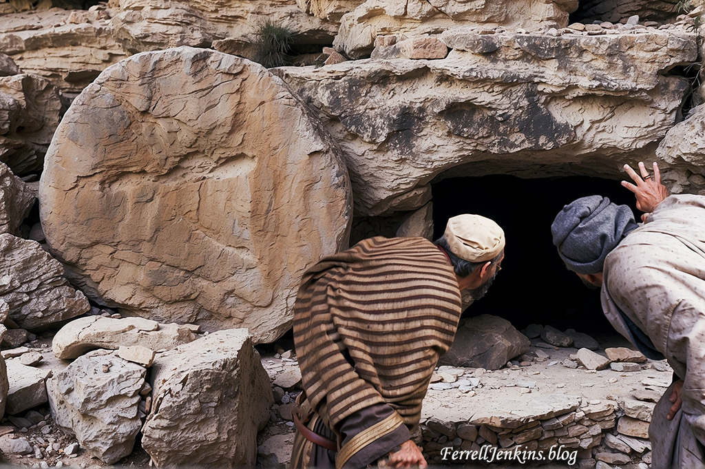
A Roman period tomb cut from stone, using a rolling stone to cover the opening.
The following text is taken from the Gospel of John, chapter 20.
Now on the first day of the week Mary Magdalene came to the tomb early, while it was still dark, and saw that the stone had been taken away from the tomb. So she ran and went to Simon Peter and the other disciple, the one whom Jesus loved, and said to them, “They have taken the Lord out of the tomb, and we do not know where they have laid him.” So Peter went out with the other disciple, and they were going toward the tomb. Both of them were running together, but the other disciple outran Peter and reached the tomb first. And stooping to look in, he saw the linen cloths lying there, but he did not go in. Then Simon Peter came, following him, and went into the tomb. He saw the linen cloths lying there and the face cloth, which had been on Jesus’ head, not lying with the linen cloths but folded up in a place by itself. Then the other disciple, who had reached the tomb first, also went in, and he saw and believed; for as ye they did not understand the Scripture, that he must rise from the dead. Then the disciples went back to their homes. (Jn. 20:1-10 ESV)
Imagine the emotions of the disciples of Jesus, both women and men, when they were told that the tomb that had been so carefully secured on Friday was found empty on the first day of the week, with only the grave clothes and the cloth that covered the head still in the tomb.
[The second photo showing the disciples of Jesus at the open tomb was made in Leonardo AI. David Padfield assisted me in this project.
Even though I have made and posted several photos of the so-called “Jesus Boat” each time the photos look different. This can be due to using a different camera or of the lighting at the display.
Roman Period Boat Discovered in the Sea of Galilee in 1986.
After two years of drought a boat that belonged to the Roman period (dated from the first century B.C. to the first century A.D.) was discovered buried in the mud on the shore of the Sea of Galilee in January, 1986, by two members of the Kibbutz Ginosar. The boat measures 26.90 x 7.55 feet. Shelly Wachsmann, nautical archaeologist for the Israel Antiquities Authority and Museums, says,
“The boat was most likely used for fishing and transport of people and cargo. It could have been sailed, or rowed by a crew consisting of four oarsmen and a helmsman.” – (An Ancient Boat Discovered in the Sea of Galilee, a brochure once sold at the Museum.)
The boat is now displayed in the Yigal Allon Centre at Kibbutz Ginosar.
A more detailed article posted here provides more information and photos.
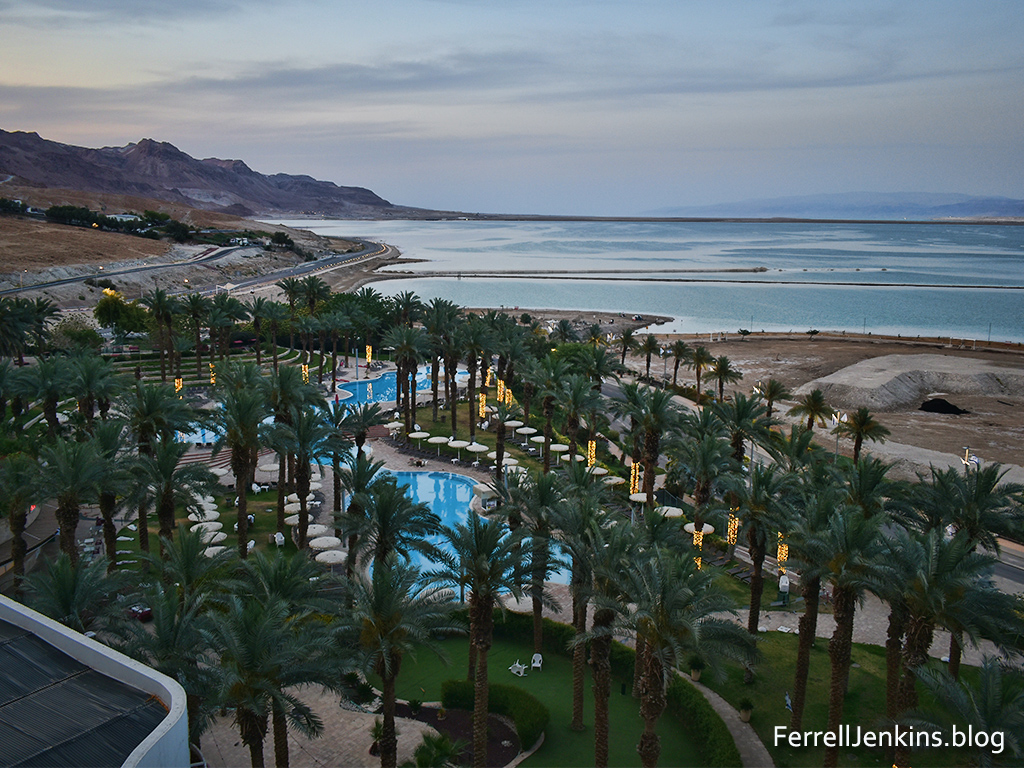
Paulette and I enjoyed two weeks of travel in Israel the first part of May. It was her first opportunity to see and learn the land. I led tours to the Bible world almost annually from 1967 to 2016 and have made personal study trips to Israel or some other part of the Bible world with a friend every year except the first year of the recent pandemic. I wanted to show Paulette places that she had read about many times in her Bible study. Though she believes the Biblical accounts about the activities of Jesus and his disciples, as well as the judges, prophets and other writers of the Bible, I watched as the Biblical text came alive to her in a new way. We did not see as much as I had hoped but we were able to work out from Jerusalem and Tiberias on the Sea of Galilee and also enjoy a day along the Dead Sea.
We drove the full length of the Dead Sea, south and north. Here are photos of some scenes that impressed us. The first one is a late afternoon view of the recreation area of the Dead Sea Resort and Spa at Ein Bokek at the southern end of the Dead Sea. The view is to the northeast. The water in this area is pumped from the deeper north. Otherwise it would be dry.
Biblical references refer to the Dead Sea as the Sea of the Arabah and the Salt Sea (Deuteronomy 3:17; Joshua 3:16). The Greeks called it Lake Asphaltitis (Josephus, Jewish War IV.476-450).
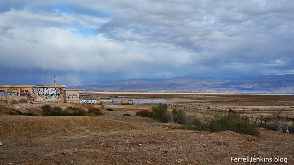
The next photo shows ruins of an old hotel or a building used by the military in the 1967 war. A hotel was there in 1967, my first trip. It was only a short walk to the water at that time, but today one can hardly see the water. We are aware that the level of the Dead Sea has continued to recede at about a meter (three feet) each year as less water flows into the Dead Sea from the north. Most of the water is pumped into reservoirs to provide water for the residents of Israel.
When I took my first class dealing with Bible geography in 1953 I learned that the Dead Sea was 1290 feet below sea level. Fairly recent reports give the surface level of the water as 1410 ft.
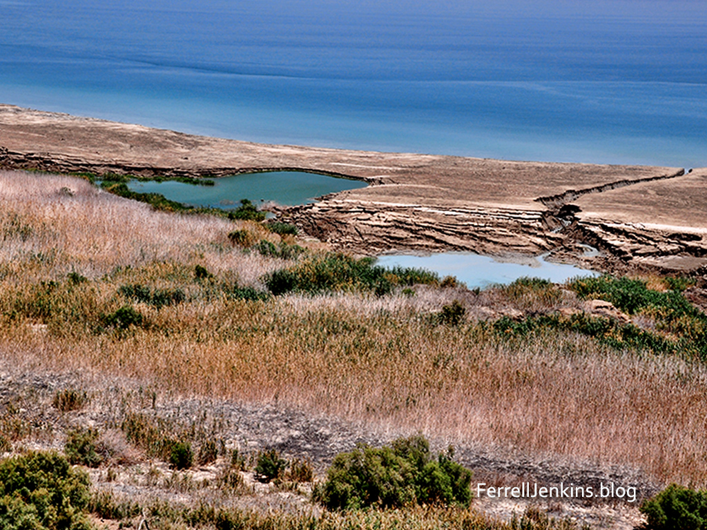
This photo below shows some of the sink holes that have recently developed on the west side of the Dead Sea near the northern end. A few years ago the water came almost to the highway.
We have written about the Dead Sea on several occasions. As always, we suggest that you use the Search box to seek information and photos for this and other Biblical places and topics.
This story must begin about 21 miles east of Ebenezer at Shiloh. After Joshua and the children of Israel conquered most of the land that had been promised to Abraham and his seed, the Biblical text says, “Then the whole congregation of the people of Israel assembled at Shiloh and set up the tent of meeting [tabernacle] there. The land lay subdued before them.” (Joshua 18:1 ESV).
Later, in the biblical periods of the judges and kings the Philistines who were settled mostly on or near the southern coastal plain of the land made attempts to reach the central mountain range through the valleys. Think of Elah, Rephaim, and Jezreel. There are also other main routes connecting the coastal plain and the mountains such as the road from Ebenezer to Shiloh (see the map in the previous post).
Murphy-O’Connor, The Holy Land, p. 188: One of the little forward Israelite settlements may still be seen to the north of Rosh Ha- Ain at Izbet Sarta, which is on the little wooded hill to the right of the Trans-Samaria Highway (route 5/505) at 2.7 km east of the Qesem Junction. The site is plausibly identified with Eben-ezer. In this aerial photo the tel of Isbet Sartah is located below the word Jenkins.
At one point the Israelites decided to bring the ark of the covenant from Shiloh to the battlefield in the vicinity of Ebenezer (1 Samuel 4). Israel was defeated and the Philistines took the Ark of the Covenant with them first to one of their towns and then another. Eventually the Ark was returned to the Israelites. In the time of King David, it was bought to Jerusalem to what would become the temple mount and placed in a tent (2 Samuel 6:15ff.).
On the trail to the top of the hill of an Israeli national park where Izbet Sartah is located. Leon Mauldin snapped this photo of the author.
The term Ebenezer is used in the Bible to identify a place, and also to refer to a stone monument indicating that God has helped us to this point. This is the sense in which the term is used in the song “Here I Raise My Ebenezer.”
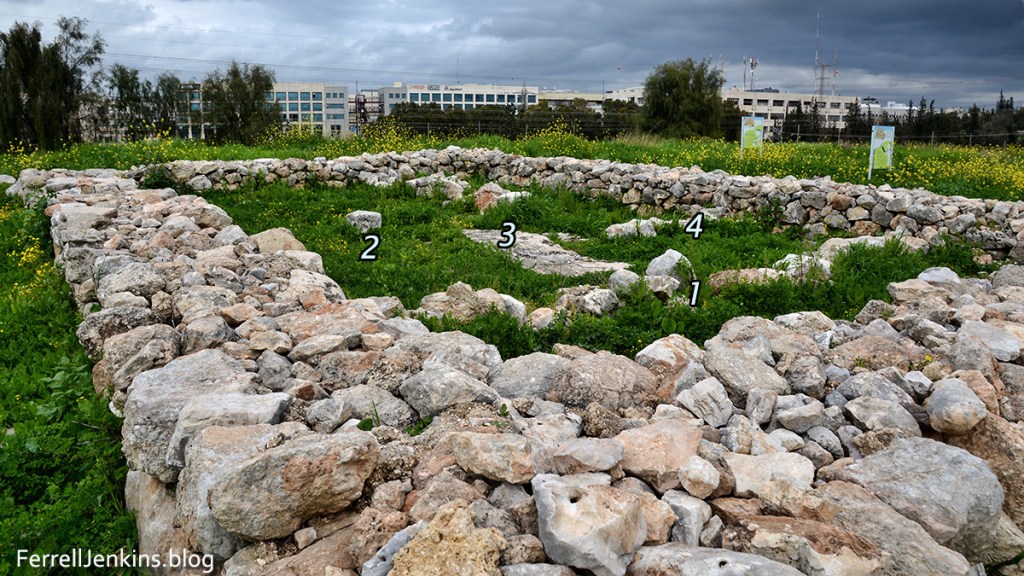
The four-room house is the only structure discovered at Isbet Sartah. There are several large pits or silos around the structure.
There is still some question about the location of Ebenezer. Excavations were carried out at Isbet Sartah by M. Kochavi in the 1970s. During these excavations a four-room house surrounded by several pits or silos was uncovered. The dig director and some other scholars identified the site with Ebenezer. It seems that there was never a settled village at the site.
Getting to the site is not easy. If you use Google Earth Pro search for Izbet Sartah to locate the site. I found that following one of the eastern-most streets from south to north will take you to the foot of the hill on which the site is located. From there, enjoy the hike.


You must be logged in to post a comment.