Category Archives: Turkey

Visualizing Isaiah 11: the River

Immediately upon looking at Isaiah 11 I think of the reference to the Messiah –  “a shoot from the stump of Jesse.” Look back to chapter 4 for an illustration for that.

I could show you individual photos of many of the animals mentioned in verses 6-7, but I do not have the wild and vicious with the tame and gentle. It doesn’t happen in the animal kingdom, but it is true in the kingdom of the Messiah. See, for example, Colossians 3:11 where there is not Greek and Jew, circumcised and uncircumcised, barbarian, Scythians, salve, free. In Christ these distinctions are broken down.

Here I have chosen to concentrate on the promise of the return of a remnant from captivity, an event that took place initially in 536 B.C.

And the LORD will utterly destroy the tongue of the Sea of Egypt, and will wave his hand over the River with his scorching breath, and strike it into seven channels, and he will lead people across in sandals. And there will be a highway from Assyria for the remnant that remains of his people, as there was for Israel when they came up from the land of Egypt. (Isaiah 11:15-16 ESV)

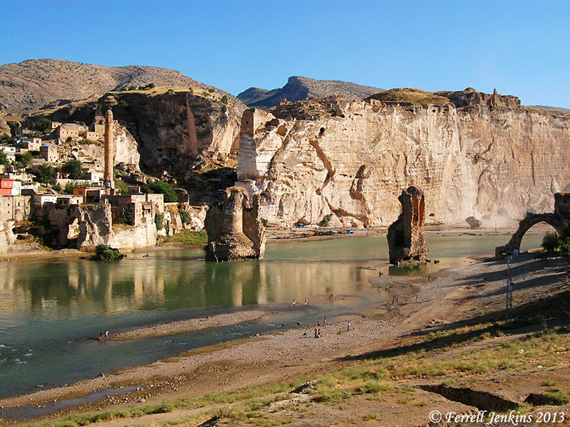
The Euphrates is the largest, longest and most important river of Western Asia. It is nearly 1800 miles long and was the northeastern boundary of the land promised to Abraham (Genesis 15:18). The empires of Assyria and Babylon, the greatest enemies of Israel, were east of the Euphrates. The Old Testament prophets often put the Euphrates by metonymy for these countries to designate the place from which the punishment of God would come (Isaiah 7:20; 8:7; Jeremiah 46:10

The Euphrates was so significant in the history of Israel that the phrase “the River” is used frequently in the Old Testament to indicate the Euphrates.

View north of the Euphrates River at Berecik, Turkey. Photo by Ferrell Jenkins.

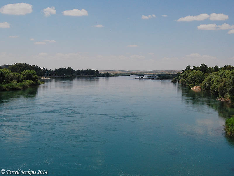
The Euphrates River, looking north, at Birecik, Turkey. Photo by Ferrell Jenkins.

The LORD said that He would bring “the waters of the River, the king of Assyria and all his glory” like a flood to rise to the neck of His people (Isaiah 8:6-8). Now He promises to strike the River and allow His people to return from the exile in sandals. In fact, He says, “there will be a highway from Assyria for the remnant that remains of his people” 11:16).

When Assyrian kings stated in their annals that they crossed the river Euphrates they mean that they went to war against nations west of the River.

Visualizing Isaiah: a booth in a vineyard

Because the events of the Bible took place in the Ancient Near East, we expect it to use illustrations from that world. Many of these cultural practices are different from those we know, but others are similar.

The prophet Isaiah describes what will happen to Jerusalem as a result of their sin.

And the daughter of Zion is left like a booth in a vineyard, like a lodge in a cucumber field, like a besieged city. (Isaiah 1:8 ESV)

Almost everyone has seen a fruit or vegetable booth along a highway during the picking season. Months later we may see that same booth in disrepair. In Biblical times, watchtowers and temporary booths were set up in fields to provide a moment of shade for the workers.

Our photo today was made a few miles east of Sardis (Revelation 3:1) in modern Turkey. It is near a vineyard and set amidst another crop. One can easily image it still standing in disarray when the winter rains come.

A booth in the field, east of Sardis. Photo by Ferrell Jenkins.

A temporary booth in the field, east of Sardis. Photo by Ferrell Jenkins.

The Judeans of the 8th century B.C. could easily visualize what Isaiah was describing, and those who were living when the city was destroyed by the Babylonians would see it as a fact.

Jeremiah’s lament over the city after 586 B.C. illustrates the point:

How lonely sits the city that was full of people! How like a widow has she become, she who was great among the nations! She who was a princess among the provinces has become a slave. (Lamentations 1:1 ESV)

Church History book available for Kindle

Do you have a good book on Church History? I have observed that many church members are generally ignorant of church history. A few months ago I learned that two books by Zondervan were to be available in Kindle format for $3.99 each. The second volume in the series was available, but there was some delay in getting the first volume online. Volume two is available today for $3.99. For how long I do not know.

51YVjpXge3L

Everett Ferguson’s Church History ,Volume One: From Christ to Pre-Reformation: The Rise and Growth of the Church in Its Cultural, Intellectual, and Political Context: 1, is currently available for the Kindle for $3.99. The regular price for the Kindle edition is $44.99. This book begins with the historical setting for the coming of Christ and the establishment of the church. It ends at about 1300 A.D.

Ferguson is widely respected as a scholar in early church history. With a Ph.D. from Harvard, he is professor emeritus of Bible and distinguished scholar-in-residence at Abilene Christian University. He is author of several books on early Christianity.

An eBook like this could be helpful for travelers visiting the Bible lands. In Turkey, for example, one sees the development of the Church Councils. In Italy there is the rise of the papacy and Catholicism. The Crusades involved numerous countries, including Israel. Sections on monasticism and the rise of Islam can be helpful as well. Ferguson also covers the “Dark Ages” and sets the stage for the earliest Reformation efforts.

Our photo shows ruins of The Church of Mary, also called the Church Council Church, at Ephesus. In A.D. 431 the Council of Ephesus was conducted here.

Church Council Church at Ephesus. Photo by Ferrell Jenkins.

Church of Mary (Church Council Church) at Ephesus. Photo by Ferrell Jenkins.

HT: Brooks Cochran

Hiking Abraham’s footsteps

The full title of this Haaretz article is “Hiking in Abraham’s footsteps, from Turkey to the Holy Land.” Sounds incredible at the moment. To hike this complete trail from Haran (Genesis 12:4) to Beersheba (Genesis 21:31) (not to mention the trip to Egypt) requires travel in Turkey, Syria, Jordan, Israel, and the Palestinian Authority (West Bank).

Among the leaders back of the concept is David Landis and his wife Anna Dintaman, developers of the Jesus Trail from Nazareth to the Sea of Galilee. Their book, Hiking the Jesus Trail and Other Biblical Walks in the Galilee, is worthwhile even for those who do not plan to walk the trail.

Larry Haverstock walked the Jesus Trail in 2011. I see that Larry’s posts about the experience is still available on his blog. See the 3rd Journey. You will find some fascinating stories along with beautiful photos you may never see from a bus or car.

Larry Haverstock in the Zippori Forest north of Nazareth.

Larry Haverstock in the Zippori Forest north of Nazareth.

The link to the Haaretz article may be accessed here. In order to read the full article you must register for free access to 10 articles a month.

Don’t expect to walk the Abraham Path from Haran (in Turkey) to Beersheva [Beersheba], but you might be able to walk small portions of the trail everywhere except the part going through Syria.

There are many hiking trails in Israel, but most of these avoid contact with the Palestinian Authority. The new plan seeks to involve the local people in the development of facilities useful to hikers.

If you like hiking, or if you appreciate the geography of the Bible lands you will probably enjoy the article. Abraham Path has a nice web site with maps and photos here.

I don’t know what, if any, relationship there is between the Abraham  Path and the Patriarchs Way, a trail that is said to run from Beersheba to Nazareth. The defacing of the sign to eradicate the Arabic indicates one of the problems either trail might face. One often sees this sort of thing on signs pointing to Christian sites.

Sign pointing to Patriarchs Way off Hebron Road (Hwy. 60) south of Bethlehem . Photo by Ferrell Jenkins.

Sign pointing to Patriarchs Way off Hebron Road (Hwy. 60) south of Bethlehem . Photo by Ferrell Jenkins.

Walk the Land : A Journey on Foot through Israel, by Judith Galblum Pex, is a fascinating account of a couple who walked the Israel Trail from Eilat to Dan.

The Lachish letters (ostraca)

The first major archaeological excavation at Tell ed-Duweir (= Tel Lachish) was called the Wellcome-Marston Archaeological Research Expedition, directed by James Leslie Starkey. During that expedition, in 1935 eighteen pieces of broken pottery with writing were found in a room outside the city gate. Three more pieces were found in 1938. J. A. Thompson explains the importance of the letters:

They represent correspondence between the military commander of Lachish, a certain Yoash, and outpost commanders, in the days when Nebuchadnezzar was closing in on Jerusalem. Most of these letters are poorly preserved, but six of them give useful information about the time. (The New International Dictionary of Biblical Archaeology)

The room outside the gate where the "letters" were found. Photo by Ferrell Jenkins.

The room outside the gate where the “letters” were found. Photo by Ferrell Jenkins.

Jerusalem was destroyed by the Babylonians in 586 B.C. These letters were written shortly before that time and were in the room at the time of the destruction of Lachish. Take a look at the biblical evidence. The prophet Jeremiah describes a time when only the Judean cities of Lachish and Azekah were left.

when the army of the king of Babylon was fighting against Jerusalem and against all the cities of Judah that were left, Lachish and Azekah, for these were the only fortified cities of Judah that remained. (Jeremiah 34:7 ESV)

Lachish Letter #4 indicates that only Lachish was left at the time of writing.

“And let (my lord) know that we are watching for *[fire] signals of Lachish, according to all the indications which my lord hath given, for we cannot see Azekah” (Pritchard, The Ancient Near East).

Letter #3 mentions a prophet.

And as for the letter of Tobiah, servant of the king, which came to Shallum son of Jaddua through the prophet, saying, ‘Beware!, thy servant hath sent it to my lord. (Pritchard, The Ancient Near East)

D. Winton Thomas says that this is “the first occurrence in non-Biblical texts of the common Hebrew word for prophet (nabi).”

One of the Lachish letters displayed in the British Museum.

Lachish Ostracon II displayed in the British Museum. The word “Yahweh” [yhwh] is used as the first word (on right) of line 2 in this letter.

The prophet Jeremiah may not be the prophet mentioned in Letter #3, but he was a prophet in Judah at the same time, and he wrote about the same situation. Notice Jeremiah 34:6-7 again.

Then Jeremiah the prophet spoke all these words to Zedekiah king of Judah, in Jerusalem, when the army of the king of Babylon was fighting against Jerusalem and against all the cities of Judah that were left, Lachish and Azekah, for these were the only fortified cities of Judah that remained. (Jeremiah 34:6-7 ESV)

This example provides wonderful corroborating evidence for the historical trustworthiness of the writing of Jeremiah.

Snow in Israel

Today I have been reading of snow in Lebanon and Israel. There are reports that a foot of snow has fallen in Jerusalem in the past day. Todd Bolen links to the Jerusalem Post (with photos) and other snow links here.

My friend Elie just sent a photo of his back yard. This is in Bar Giyora, a town on Hwy. 375 between Bethlehem and the Valley of Elah. The town is located in the hill country of Judea.

Snow in the mountains of Judea. Photo by EMB, 12/14/13.

Snow in the mountains of Judea. Photo by EMB, 12/14/13.

“For as the rain and the snow come down from heaven and do not return there but water the earth, making it bring forth and sprout, giving seed to the sower and bread to the eater, so shall my word be that goes out from my mouth; it shall not return to me empty, but it shall accomplish that which I purpose, and shall succeed in the thing for which I sent it.” (Isaiah 55:10-11 ESV)

Here is a photo of the general area along Hwy. 375 with a view east toward the central mountain ridge (without snow).

Judean Hills. View east to central mountain range from Hwy. 375. Photo by Ferrell Jenkins.

Judean Hills. View east to central mountain range from Hwy. 375. Photo by Ferrell Jenkins.

On the Facebook page of Jerusalem University College you will find several nice photos of the snow in Jerusalem. Check here.

Zondervan Essential Atlas of the Bible

Frequently we have mentioned and recommended the Zondervan Atlas of the Bible by Carl G. Rasmussen. Every Bible student needs at least one or two good atlases to assist them in their study of the Scriptures.

Last month I attended some annual professional meetings in Baltimore and was pleased to see that Zondervan already had copies of the new Zondervan Essential Atlas of the Bible. One of the sales reps gave me a copy for review here.

At first appearance, the ZEAB has a beautiful cover of stiff, durable paper. It is a convenient 9 1/8″ x 7 3/8″ in size. The content is basically the same as the larger hard back edition. There has been some editing of the text to condense the book from 303 pages to 159 pages.

There are two major sections to the book: Geographical Section and Historical Section. The Geographical Section includes an Introduction to the Middle East as a Whole, and discusses the geography of Israel and Jordan, Egypt, Syria and Lebanon, and Mesopotamia.

The Historical Section covers the entire Bible from the Pre-Patriarchal Period to the Seven Churches of Revelation, with an additional chapter on Jerusalem, in 17 chapters.

The maps are superbly drawn and easy to read. A timeline accompanies each chapter. Rasmussen is noted for his Holy Land Photos web site. The photos are beautiful and helpful in illustrating the content.

This book has been prepared by a teacher, and I consider that a plus. In addition to his work at Bethel University, Carl continues to serve as an adjunct professor at Jerusalem University College. He has spent 16 years of his adult life in the Bible lands. His  Holy Land Photos’ Blog provides helpful, up-to-date, information about both familiar and unfamiliar places mentioned in the Bible. He has also led numerous tours through Bible lands.

This Atlas sells for $16.99. I see that Amazon has the Zondervan Essential Atlas of the Bible for $12.97. A Kindle version is about $3 less.

Either version is ideal for a person to take with them to Bible class, or on a tour of Bible lands.

The larger Zondervan Atlas of the Bible still remains indispensable for the serious student. I am trying to say you should have both books.

Carl has assisted me on several occasions in locating some of those hidden, out-of-the-way, places that most visitors to the Bible lands never see. I am pleased to commend this new edition of his book.

Excitement at Carchemish

It must have been exciting to be at Carchemish in 605 B.C. when Pharaoh Neco came all the way from Egypt to this city now on the border between Syria and Turkey. On an earlier excursion from Egypt to Carchemish in 609 B.C., Neco killed Josiah, king of Judah, at Megiddo.

Pharaoh Neco came to assist the Assyrians as they fought the Babylonians. But the emerging world power from the southern Euphrates city of Babylon overpowered the Assyrians and the Egyptians and sent Neco running back to Egypt. Nebuchadnezzar, king of Babylon, chased Neco to the border of Egypt.

It is still exciting at Carchemish. I have been within sight of Carchemish once. The military installations were clearly visible on top of the tell. The tour operator handling my tour in Turkey a previous time advised me not to go to Carchemish (Karkamis) because it is “zero on the border” of Turkey and Syria.

Carchemish with a Turkish military base on top. Photo by Ferrell Jenkins 2007.

Carchemish with a Turkish military base on top. Photo by Ferrell Jenkins 2007.

We were excited to learn that new excavations had begun at Carchemish. That was before the recent “uncivil war” in Syria. Now, two reports give a little glimpse into the archaeological work there.

The first report from the WorldBulletin reports:

What could be the largest discovered inscribed tablet (stele), dating to the reign of Babylonian king Nebuchadnezzar II between 605-562 BC, has been discovered in the Turkish city of Karkamis on the military zone along the Turkey-Syria border.

Noting that the excavations sites are untroubled despite their proximity to the Syrian civil war, Dr. Nicola Marchetti said the Karkamis archeological museum is scheduled to open next year.

“Excavations are right on a military zone with 55 hectares in Turkey and 35 in Syria,” said Marchetti, the head of the Turkish and Italian excavation teams, at a press conference held in the Assembly Hall of the Metropolitan Municipality.

Excavations this year also unearthed a cuneiform tablet at the palace of Carchemish king Katuwa dating to 800 BC, as well as over 300 sculptures, a Luwian hieroglyphic inscription and a mosaic.

Read the full report here. I assume the work described in this report is somewhere other than the top of the high mound.

A report from ANSAmed used a few more words about the stele dating to the reign of Nebuchadnezzar.

Marchetti is proudest of a stele, or commemorative slab, carved with the face of Babylonian King Nebuchadnezzar, the conqueror of Karkemish. He destroyed Jerusalem and the Temple of Salomon in 587 BC, and built the Hanging Gardens of Babylon, which were the seventh wonder of the ancient world.

”It’s a beautiful, compact piece of limestone”, Marchetti enthuses of this unique, historic find.

This report may be read here. It continues to tell about some recent al-Qaeda activity near the border in Syria affected by the excavation.

While it’s an almost peaceful cohabitation, it is also true that the dig is within a Turkish military base. This offers the Italians a relative sense of safety – except on September 3, when al-Qaeda attacked the Syrian town of Jarabulus, eventually wresting it from the ”official” anti-Assad Free Syrian Army (FSA) insurgents. ”It was hell on earth. Bullets were flying everywhere”, says Marchetti, who teaches Near Eastern archeology at Bologna University.

”Luckily, archeologists dig holes. We dove in. We kept digging inside the deeper ones. The Turkish military kept telling us, stay down”. Calm was restored once the FSA fighters gave themselves up to the Turks in order to flee al-Qaeda. An armed truce has held since, allowing the Italian team to unearth new treasures.

Now we know why archaeologists dig trenches and holes.

I look forward to seeing that new archaeological museum at Karkamis. Karkamis is a small town of less than 5000 population.

HT: Jack Sasson

Report by Gordon Franz on the “International Noah and Judi Mountain Symposium” – Sirnak, Turkey

Gordon Franz sent me the report on his recent visit to southeastern Turkey and the “International Noah and Judi Mountain Symposium.” He said, “If you want to post it on your site, you are more than welcome.” This is an issue of much importance, and I am delighted to share it with our readers and help give it wide distribution.

Twice I have visited Eastern Turkey. In 2007 I was aware of the argument for Cudi Dagh (or Mount Judi), but was advised by my Turkish tour operator not to go to the mountain. Still hopeful of seeing the mountain someday.

Here is the first part of Gordon’s report:

Report on the “International Noah and Judi Mountain Symposium” – Sirnak, Turkey

By Gordon Franz

Introduction
The “International Noah and Judi Mountain” symposium was held in Sirnak, Turkey, under the auspices of Sirnak University. One of the purposes of this conference was to set forth the case for Cudi Dagh, the mountain just to the south of Sirnak, as the landing-place of Noah’s Ark in South East Turkey. This mountain is not to be confused with the (late) traditional Mount Ararat, called Agri Dagh, in northeastern Turkey.

Ararat (Agri Dagh) in north eastern Turkey. Photo by Ferrell Jenkins.

Traditional Mount Ararat (Agri Dagh) in north eastern Turkey. Photo by Ferrell Jenkins.

Interestingly, at this conference I learned of another mountain that allegedly Noah’s Ark landed on. It is located at Mount Gemikaya in Azerbaijan. By my count, that is the sixth mountain vying for the honors of this historical event: two in Turkey, three in Iran, and one in Azerbaijan. The Iranian and Azerbaijani sites are far outside the Land of Ararat / Urartu, and in the case of the Iranian sites, deep inside the Land of Media. We can safely dismiss these mountains as the place where Noah’s Ark landed according to the Bible. To be truthful, Agri Dagh must be dismissed as well because it is a post-Flood volcanic peak in a plain, and not within the “mountains (plural) of Ararat” (Gen. 8:4).

The Setting of the Symposium
The symposium was held at the Sehr-I Nuh Otel (translation: Noah’s City Hotel) in Sirnak, just north of Cudi Dagh (Cudi or Judi Mountain). This mountain is within the “mountains of Ararat” (Gen. 8:4) where Noah’s Ark landed. The facilities at the hotel were first class, the food was absolutely delicious, and we had a spectacular view of Cudi Dagh from the panorama view windows as we ate our meals.

Cudi Dagh (Mount Judi). Photo courtesy of Dr. Mark Wilson.

Cudi Dagh (Mount Judi). Photo courtesy of Dr. Mark Wilson.

Special thanks goes to Dr. Mehmet Ata Az, a philosophy professor at Sirnak University, for coordinating the speakers and making sure our needs were met. He truly has a servant’s heart and our best interest in mind. Thank you my friend!

— ♦ —

At this point Gordon gives a synopsis of select papers, including his own on the topic, “Did Sennacherib, King of Assyria, Worship Wood from Noah’s Ark?

Read the report in its entirety at Gordon’s Life and Land Seminars site. I think you will be profited, and perhaps enlightened, by doing so.

The Assyrians at the Source of the Tigris River

The Tigris River (called Dicle in Turkish) begins in the mountains of ancient Ararat and flows to the Persian Gulf. The Tigris is mentioned twice in the Bible. It is said to be the third of the rivers flowing out of the garden of Eden. It flows on the east side of Assyria (Genesis 2:14). The river is also mentioned in Daniel 10:4. The prophet stood beside “the great river, the Tigris.” Ancient Nineveh, near Mosul in northern Iraq, was built on the Tigris.

The Tigris River south of Diyabakir, Turkey. Photo by Ferrell Jenkins.

The Tigris River south of Diyabakir, Turkey. Photo by Ferrell Jenkins.

Ziyaret Tepe is identified with the Assyrian city of Tushhan. The city dates back to the Early Bronze Age (about 3000 B.C.), but there is a concentration of interest in the Late Assyrian period, c. 882–611 B.C. This corresponds to the biblical period of the Divided Kingdom.

Dr. Tim Matney, director of the Ziyaret Tepe Archaeological Expedition in southeastern Turkey, writes today about a visit to the source of the Tigris.

About 90km north of Diyarbakir there is a place in the Taurus Mountains where the Dibni Su, one of the two main sources of the Tigris River, comes flowing out of a large cave. The Dibni Su actually originates much deeper in the mountains, but the ancient Assyrians thought this to be the source of the Tigris and it is a dramatic landscape that had great significance to them. The modern name of the place is Birkleyn Gorge.

Take a look at three nice photos posted by Matney at the Ziyaret Tepe website here.

Matney says there are four small rock inscriptions made by Assyrian kings Tiglath-pileser I (1114–1076 B.C.) and Shalmaneser III (858–824 B.C.). Six Bible references may be found for Tiglath-pileser (2 Kings 15:29; 16:7,10; 1 Chronicles 5:6,26; 2 Chronicles 28:20), and two for Shalmaneser (2 Kings 17:3; 18:9). [See Comments below. The biblical kings are Tiglath-pileser III (745–727 B.C.), and Shalmaneser V (726–722 BC). Perhaps I will say more about these kings in a future post. My oldest son and I have the same name, and sometimes folks get us mixed up unless they know us.]

Ziyaret Tepe is scheduled to be flooded by the Tigris River as part of the project by the Turkish government to provide power and irrigation for the southeastern region of Turkey.

I have not visited Ziyaret Tepe, but have visited the general area (Diyabakir, Batman, et al. The photo below was made at Hasankef, an old town also scheduled to be flooded by the Tigris.

The Tigris River at Hasankef in southeastern Turkey. Photo by Ferrell Jenkins.

The Tigris River at Hasankef in southeastern Turkey. Photo by Ferrell Jenkins.

In addition to the Ziyaret Tepe blog, there is an interesting report on the site, with maps, at Past Horizons.

HT: Jack Sasson