Category Archives: Travel

Planning for earthquakes in Eastern Turkey

Last week I wrote about references to earthquakes in the Bible. In 2007 I traveled in Eastern Turkey, in the Biblical land of Ararat (Urartu) (2 Kings 19:37). Along the road between Van and Batman we saw a group of men adding a room to a house.

Notice that the house is built of field stones. Above the window there is a lintel of wood. To the right side of the window you may also see a long piece of wood. I will come back to that later. Notice the roof. It is made of timber, straw, and mud.
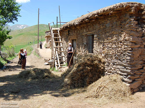
House between Van and Batman in Eastern Turkey. Photo by Ferrell Jenkins.

House between Van and Batman in Eastern Turkey. Photo by Ferrell Jenkins.

The photo below shows one of the men working on the roof of the new room. Notice the mud roof of the existing room.  The worker is preparing a piece of timber with a simple hand tool similar to those used three to four thousand years ago.
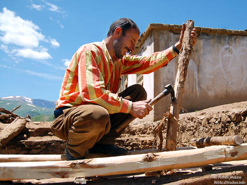
Adding a new room in the land of Ararat. Photo by Ferrell Jenkins.

Here we see part of the new wall. Notice the field stone filled with smaller stones. A wooden lintel is used over the window. That might not be unusual to us. Look below the window. The timber is not only under the window, but also extends several feet to the right.
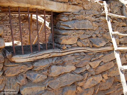
Preparing for an earthquake in Eastern Turkey. Photo by Ferrell Jenkins.

Preparing for an earthquake in Eastern Turkey. Photo by Ferrell Jenkins.

My friends and I spoke only a few words in Turkish. The men building the house spoke no English. I pointed to the wood below the window and did my imitation of the shaking of an earthquake. This evoked a good smile from one of the Turkish men. He nodded to indicate that I had the right idea. The wood helps to absorb the shock of an earthquake.

In our modern housing we use rebar to strengthen our buildings. This, along with metal ties help reinforce our buildings to resist the damage from hurricanes, tornadoes, and earthquakes. If an earthquake similar to the one in Haiti had hit southern California there likely would have been little loss of life. The buildings in Haiti were made of concrete blocks without any reinforcement. Ancient people knew they had to find ways to cushion the shock. The people of Eastern Turkey have learned the same.

In principle, Jesus taught the same thing about building.

“Everyone then who hears these words of mine and does them will be like a wise man who built his house on the rock. And the rain fell, and the floods came, and the winds blew and beat on that house, but it did not fall, because it had been founded on the rock. And everyone who hears these words of mine and does not do them will be like a foolish man who built his house on the sand. And the rain fell, and the floods came, and the winds blew and beat against that house, and it fell, and great was the fall of it.” And when Jesus finished these sayings, the crowds were astonished at his teaching, for he was teaching them as one who had authority, and not as their scribes. (Matthew 7:24-29 ESV)

Are you building on the rock?
Earthquakes common in the Bible world

Earthquakes were, and are, common in the Bible world. Earthquakes are common in Iran (Persia), Turkey (Asia Minor), Syria, Lebanon, Israel, and Jordan.

The Great Rift runs all the way from northern Syria through Lebanon, Israel, the Arabah, and into eastern Africa. In Israel the area is called the Jordan Valley or the Dead Sea Rift, It is not surprising that earthquakes are mentioned frequently in the Bible. The prophet Amos dates his visions to “two years before the earthquake” (Amos 1:1). The earthquake he makes reference to must have been so memorable that everyone would know what he was talking about. Zechariah (14:5) also calls attention to this earthquake in the days of Uzziah king of Judah.

Jesus, in predicting the fall of Jerusalem to the Romans, said, “and in various places there will be famines and earthquakes” (Matthew 24:7; see Luke 21:11).

About a year and a half ago I wrote about Philadelphia with special attention to the danger of earthquakes here. I suggest you read that post. The letter to the church at Philadelphia (Revelation 3:7-13) makes an allusion to the events that occur after an earthquake. In the promise to the overcomers the Lord says “I will make him a pillar in the temple of My God, and he will not go out from it anymore (v 12). In the case of earthquakes people stay outside for several days due to the fear of aftershocks. Those who overcome need not fear being toppled, as a pillar might be toppled in the earthquake.

He who overcomes, I will make him a pillar in the temple of My God, and he will not go out from it anymore; and I will write on him the name of My God, and the name of the city of My God, the new Jerusalem, which comes down out of heaven from My God, and My new name. (Revelation 3:12 NAU)

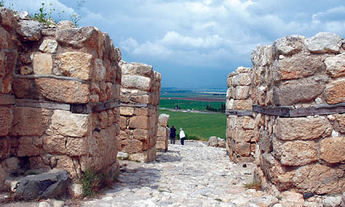
The archaeological excavations of many Biblical cities throughout Asia Minor, and along the Great Rift, reveal evidence of earthquakes. Some of the gates were built with pieces of timber to absorb the shock from the tremors. The reconstructed gate at Megiddo illustrates this practice.

Megiddo Gate with view of Jezreel Valley. Photo by Ferrell Jenkins.

Megiddo Gate with view of Jezreel Valley. Photo by Ferrell Jenkins.

The same practice is reflected in Scripture in the account of the rebuilding of the temple according to the order of the Persian King Cyrus.

In the first year of Cyrus the king, Cyrus the king issued a decree: Concerning the house of God at Jerusalem, let the house be rebuilt, the place where sacrifices were offered, and let its foundations be retained. Its height shall be sixty cubits and its breadth sixty cubits, with three layers of great stones and one layer of timber. Let the cost be paid from the royal treasury. (Ezra 6:3-4 ESV)

Tirhakah of Sudan (or Ethiopia, or Cush)?

Our post yesterday reported the discovery of a large statue of Taharqa  (English Bible: Tirhakah) deep in Sudan. Some English versions associate Tirhakah with Ethiopia (NET, NKJV). Other associate him with Cush (NAU, ESV, CSB). The Hebrew word here is Kush (or Cush).

Kenneth A. Kitchen clarifies the terminology:

The region S of Egypt, i.e. Nubia or N Sudan, the ‘Ethiopia’ of classical writers (not modern Abyssinia [Ethiopia]). The name Cush in both Hebrew and Assyrian derives from Egyptian Kš (earlier K’s, K’š), ‘Kush’. Originally the name of a district somewhere between the second and third cataracts of the Nile c. 2000 bc, ‘Kush’ became also a general term for Nubia among the Egyptians, which wider use Hebrews, Assyrians and others took over (G. Posener, in Kush 6, 1958, pp. 39–68). (New Bible Dictionary, 3rd Ed.)

The Theological Wordbook of the Old Testament comments on the term Cush (Ethiopia) as it is used in several Old Testament prophecies.

In several cases, especially in the prophets, Ethiopia is used in parallel construction as a synonym of Egypt (Isa 20:3-5; Ezek 30:4; Nah 3:9). This probably represents the dominance of Ethiopia (or, more precisely, Nubia) over Egypt between 750 and 663 B.C. Terhakah was a notable Nubian pharaoh who tried, unsuccessfully, to block Sennacherib’s westward expansion (2Kings 19:9 ; Isa 37:9). After 663 B. C. Egypt was independent of Nubia (Jer 46:9; Ezek 25:4, 5, 9).

About a year ago I visited a Nubian Village on the banks of the Nile River at the first cataract of the Nile at Aswan. The Nubians at the village originally lived south of Aswan in the ancient territory of Cush. When the new High Dam was built on the Nile the Nubians were moved to other settlements.

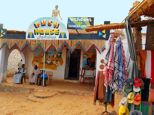
One of the interesting things I observed at the village was a shop of some sort called House of Kush (Cush). A sign on top of the building added “Welcome to Taharka Kingdom.” My point is to show the association between southern Egypt, Cush, and Tirhakah.

House of Kush (Cush) in Nubian Village at Aswan, Egypt. Photo by F. Jenkins.

House of Kush (Cush) in Nubian Village, Aswan, Egypt. Photo by F. Jenkins.

Zorah and the tomb of Samson

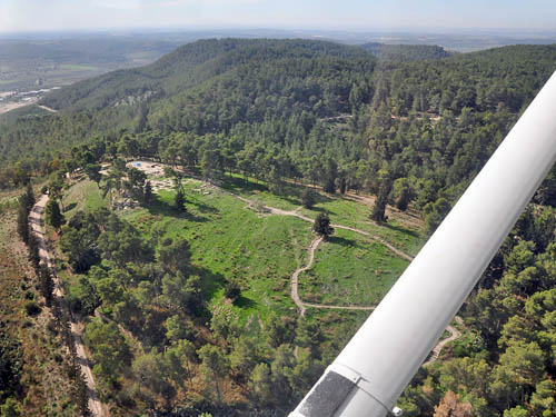
Yesterday we noted the relation between the Sorek Valley and other cities associated with Samson, Zorah and Eshtaol. This photo shows Tel Zorah which is now surrounded by a nice forest.

Aerial view of Zorah. Photo by Ferrell Jenkins.

Aerial view of Tel Zorah near the Sorek Valley. Photo by Ferrell Jenkins.

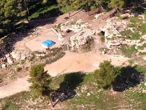
To the left of the tel you will see the Sorek Valley in the haze. In a clearing on the tel you will see something blue. This is a “tomb” dedicated to Samson. In the photo below we have a better view of the “tomb.”

Aerial view of the "tomb of Samson" at Zorah. Photo by Ferrell Jenkins.

Aerial view of the "tomb of Samson" at Tel Zorah. Photo by Ferrell Jenkins.

I have no idea when this “tomb” was erected, but I suspect it is fairly recent. The Bible recounts the death of Samson in one of the Philistine cities and his subsequent burial between Zorah and Eshtaol in the tomb of his father.

Then his brothers and all his father’s household came down, took him, brought him up and buried him between Zorah and Eshtaol in the tomb of Manoah his father. Thus he had judged Israel twenty years. (Judges 16:31 NAU)

Over the Sorek Valley and Beth-shemesh

The Israelites took the ark of the covenant from the tabernacle at Shiloh to the battle field at Ebenezer when they were fighting with the Philistines (1 Samuel 4). The ark was captured by the Philistines and taken to Ashdod, then to Gath, and finally to Ekron before they decided to get rid of it. The ark was returned to Beth-shemesh (Beth Shemesh, Bethshemesh; 1 Samuel 4-6).

Now the people of Beth-shemesh were reaping their wheat harvest in the valley, and they raised their eyes and saw the ark and were glad to see it. The cart came into the field of Joshua the Beth-shemite and stood there where there was a large stone; and they split the wood of the cart and offered the cows as a burnt offering to the LORD. (1 Samuel 6:13-14 NAU)

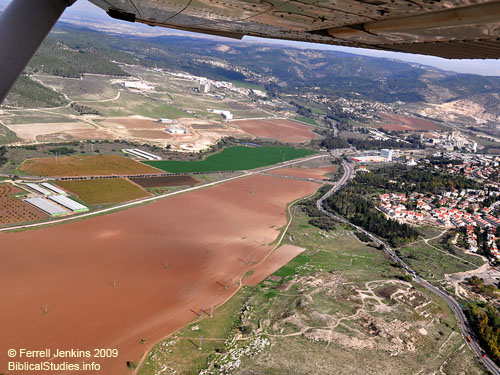
Our aerial photo today shows a portion of the Sorek Valley. The mound of Beth-shemesh, with its archaeological scarring,  is visible in the lower right corner of the photo. The view here is NE, toward the Judean Mountains. The Sorek River bed is visible curving its way along the far side of the valley.

The Sorek Valley is associated with the account of Samson and Delilah.

After this it came about that he loved a woman in the valley of Sorek, whose name was Delilah. (Judges 16:4 NAU)

Aerial view of Beth Shemesh and the Sorek Valley. Photo by Ferrell Jenkins 2009.

Aerial view of Beth-shemesh and the Sorek Valley. Photo by Ferrell Jenkins 2009.

The sites of Zorah and Eshtaol are located in the foothills of the Judean Mountains among the trees. These sites are associated with Samson.

Then the woman gave birth to a son and named him Samson; and the child grew up and the LORD blessed him. And the Spirit of the LORD began to stir him in Mahaneh-dan, between Zorah and Eshtaol. (Judges 13:24-25 NAU)

The Sorek Valley continues to the left for a few miles toward Timnah, where Samson married a Philistine woman and performed many of his exploits (Judges 14-15).

In the air above Gezer

Gezer is described by William G. Dever, one of the archaeological excavators, as “a site in the foothills of the Judean range.” He continues,

Ancient Gezer has been located at Tell Jezer (Tell el-Jazari), a 33-acre mound 5 miles SSE of Ramleh, … since C. Clermont-Ganneau first made the identification in 1870. Gezer is situated about 750 feet above sea level, on the last of the foothills of the Judean range where it slopes down to meet the Shephelah. It guards one of the most important crossroads in ancient Palestine, where the trunk road leading to Jerusalem and sites in the hills branches off from the Via Maris at the approach of the Valley of Aijalon. It is mentioned not only in the Bible, but in several Egyptian and Assyrian texts. (Anchor Bible Dictionary)

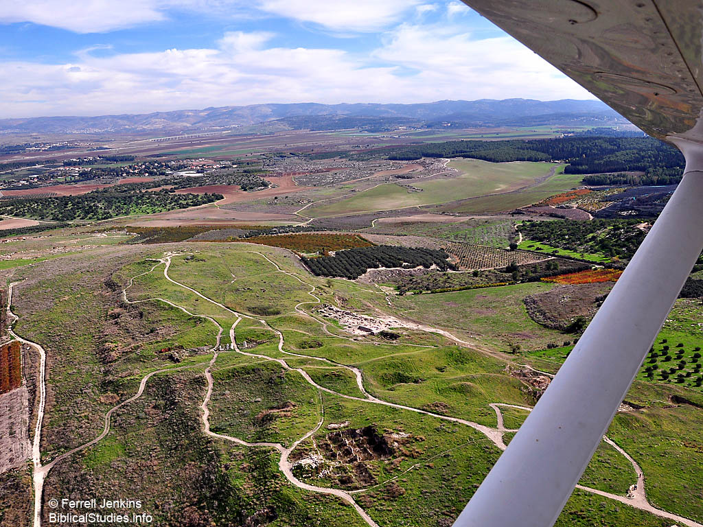
In a previous post (here) we showed the coastal plain. As we approach Gezer, looking east, we see the mountains of Judea. Click on the image for one large enough to use in PowerPoint presentations for classes and sermons. This is our New Year’s gift to our faithful readers.

View of Tell Gezer looking E toward the Judean Mountains. Photo by Ferrell Jenkins.

View of Tell Gezer looking E toward the Judean Mountains. Photo by Ferrell Jenkins

Here are a few things we learn about Gezer from the Bible.

  • The king of Gezer fought against Joshua and the Israelites during the conquest (Joshua 10:33; 12:12).
  • Gezer was allotted to Ephraim (Joshua 16:3).
  • Gezer became a city of the Levites (Joshua 21:21). It was designated as a city of refuge (1 Chronicles 6:67).
  • Israel failed to drive out the Canaanites who lived in Gezer (Joshua 16:10; Judges 1:29).
  • By the time of David the Philistine seem to be living at Gezer (2 Samuel 5:25; 1 Chronicles 14:16; 20:4).
  • Pharaoh, king of Egypt, captured Gezer, burned it, and gave it as a dowry to his daughter, Solomon’s wife (1 Kings 9:16).
  • Solomon (re)built the cities of Hazor, Megiddo, and Gezer (1 Kings 9:15-17).

Blog about Jordan sites

Dr. David Graves writes an infrequent blog called Deus Artefacta. When he does write, the material is worthwhile. David has been participating in the excavation of Tall el-Hammam in the Jordan Valley (Transjordan) east of Jericho for several years. He is working on locating the site of Roman Livias.

Tall el-Hammam in the Jordan Valley. Photo by Ferrell Jenkins 2008.

Tall el-Hammam in the Jordan Valley. Photo by Ferrell Jenkins 2008.

Dr. Steven Collins, Dean, College of Archaeology, Trinity Southwest University, thinks that Tall el-Hammam is the site of Sodom. Info about the excavation may be located here. Other scholars suggest that Tall el-Hammam is the site of Abel-shittim (Numbers 33:49; Shittim, Numbers 25:1), in the plains of Moab. See Rainey and Notley, The Sacred Bridge, 125. The Israelite spies went out from here to view the land, especially Jericho (Joshua 2:1).

The excavation at Tall el-Hammam is now in progress through January 29, 2010. Graves has posted some good photos, and associated information, about Heshbon, Umm Quis [Gadara], and Jerash in the land of Gilead. Before crossing into Jordan he spent some time with the Temple Mount Salvage Operation in Jerusalem, visited Qumran, Masada, and Jericho.

High over Israel

A guide friend in Israel notified me that one of his neighbors was experienced in aerial photography, and asked if I would be interested in going up during the recent trip to Israel. I indicated an interest and we began to work on the details. The pilot, Yoav, had to get permission and clear us with Israeli security well in advance of the flight. The first day we scheduled was scrubbed due to bad weather coming in. The following day was sunny and fairly clear. Certainly it was one of the best weather days we had during the first two weeks of December.

We flew from the Sde Dov Airport. This is a small airport along the Mediterranean coast immediately north of the Yarkon River in Tel Aviv. Arkia Airlines operates here with flights to Eilat, Rosh Pina, and perhaps other places. When we arrived at the airport to meet our friend and the pilot we had to go through strict security even though we had sent all of our passport details in advance. Once that was completed we headed for the plane, a Cessna 172 Skyhawk. Our pilot was well aware of most of the places we wanted to visit. He would tell us to be ready in two minutes, or in 30 seconds, for the best photos. We flew over Gezer, Zorah, Beth Shemesh, the Zorek Valley, Lachish, Jerusalem, the Herodium, Aphek/Antipatris, and lots of terrain in between in two hours and six minutes. I made 1754 photos during that time, filling an 8 gig card and two 4 gig cards. Probably not a Guinness record, but a record for me.

Perhaps over the next few weeks I will be able to share a few of these photos with you. Let’s begin with the Coastal (or Maritime) Plain south of Tel Aviv/Joppa. This area is also referred to as the Plain of Philistia because the Philistines lived in the region in Old Testament times. The Philistine cities of Ashdod, Ashkelon, and Gaza were in the southern coastal plain.

The plain of Philistia may be as much as 20 miles wide as we move further south. This photo gives one some idea of the territory immediately south of Tel Aviv as we fly south east to Gezer. Our altitude here was 800 feet.

The Coastal Plain of Philistia, south of Tel Aviv. Photo by Ferrell Jenkins.

The Coastal Plain of Philistia, south of Tel Aviv. Photo by Ferrell Jenkins.

This region is now an important part of Israel, but in Bible times few Israelites lived in the area.

Don’t try this on your first trip

Some adventuresome souls who have been reading the posts about the recent trip to Israel may have in mind doing the same. After all, you have some friends who went to Europe on their own, bought an Eurail pass and saw everything in two weeks.

Not that I think that is the best way to see Europe in a limited amount of time, but I definitely warn against this for the first trip or two to Israel, Turkey, Jordan, or Egypt. When you read about a trip like the one I just completed the first two weeks of December, keep in mind that I have been traveling to Israel almost annually since 1967.

Your best choice for a first or second trip to the Bible Lands (or Holy Lands) is to travel with someone who has experience in this area. Look at a lot of itineraries before you make a decision. Look at the qualifications of the person leading the tour. Examine carefully the details such as class of hotels, number of meals, etc.

The most important thing you can do is to study about the places you will visit for several months in advance of the trip. A few weeks ago we presented a list of books that we suggest for this purpose here. Your most important study will come during the first year after you return from your trip. Because then you will have a better understanding of what you are reading about.

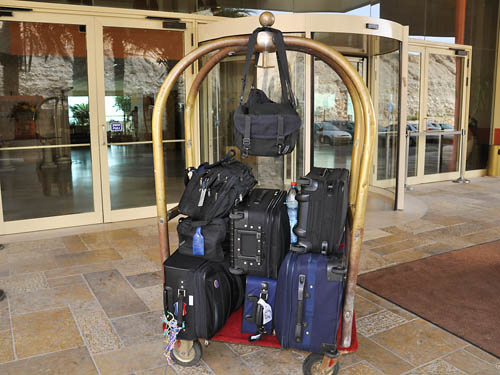
And don’t take too much luggage. It can spoil a good trip. I caught this photo of two tourists coming out of a hotel near the Dead Sea. Perhaps they had packed for a group.

Overloaded at the Dead Sea.

Overloaded at the Dead Sea. Photo by Ferrell Jenkins.

“Cracked Pot Archaeology”

If you have not taken a look at Life and Land by Gordon Franz, I suggest you do so now. Gordon is a careful scholar. His material is always well researched and documented. One category that caught my attention at Life and Land is called Cracked Pot Archaeology. Here is how he describes this category.

The Cracked Pot Archaeology category contains articles about popular, contemporary archaeological theories and ideas that, like cracked pots, hold no water! These articles are a review, scholarly analysis and critiques of theories and ideas that have been presented on the Internet or popular books, movies, DVD’s and videos.

Over the past few years Gordon has written a number of articles about the claims of the late Ron Wyatt and Robert Cornuke. Last evening I presented a lesson on “Ports of Paul.” I only had time to talk about Caesarea Maritima and the events of Acts 27-28 (Malta, Syracuse, and Rhegium). I called attention to the claim of Robert Cornuke and the response by Gordon Franz. You will find his response to Cornuke’s book, The Lost Shipwreck of Paul, under the category of Paul and Places. Gordon provides information about the possible places on Malta where the shipwreck may have occurred. I will leave any discussion of that at this time, and let you enjoy working through his material.

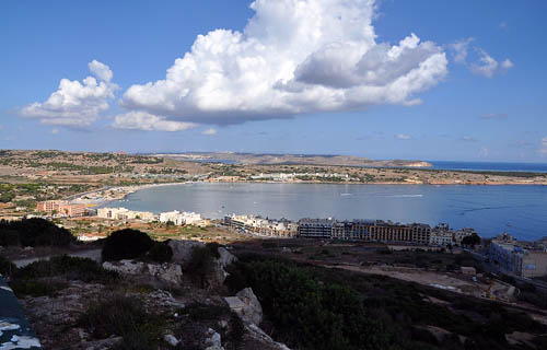
The photo below shows Mellieha Bay on Malta. Beyond the bay you may see the island of Gozo. Mellieha Bay is a few miles north of St. Paul’s Bay, the traditional site of the shipwreck. We discussed several places on Malta back in September here, here, and a few other places (use the Search box to locate places you are studying).

Mellieha Bay, Malta. Photo by Ferrell Jenkins.

Mellieha Bay, Malta. Photo by Ferrell Jenkins.

One of Gordon’s recent articles is a response to Cornuke’s claim to have found an inscription with the name of Yahweh on it. Read it here. The final sentence by Franz sums it up:

The assertion that Mount Sinai is at Jebel al-Lawz in Saudi Arabia still lacks credible and verifiable historical, geographical, archaeological, or biblical evidence.

You will find links to articles dealing with the claim that Jebel al-Lawz in Saudi Arabia is Mount Sinai.

A word of warning. Beware of someone who has discovered something all others have overlooked. Be especially wary if they have found two things no one else knows about. Shall I keep counting?