Category Archives: Israel

The topography of Kir-hareseth

Kir-hareseth figures prominently in a story recorded in 2 Kings 3. After the death of Ahab (853 B.C.), Mesha, king of Moab, rebelled against the king of Israel. Jehoram (or Joram; 852–841 B.C.), the king of Israel, did not want to give up the tribute that Mesha had been paying Israel. Jehoram prepared for war and convinced Jehoshaphat (870/69–848 B.C.), king of Judah, to join him to engage Mesha in war. They  decided to take the long, circuitous wilderness route. They would go south of the Dead Sea and approach Moab from the south through Edom.

In the map below you see that Kir-hareseth (site of Karak or Kerak, Jordan) sits only a few miles from the desert and the ancient King’s Highway. The famous Karak Crusader castle provides a view to the west toward the Dead Sea.

Location of Kir-hareseth, modern Kerak in Jordan.

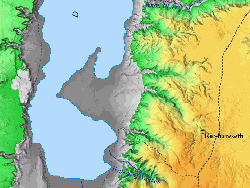
Location of Kir-hareseth, modern Karak in Jordan.

Notice that a valley runs northeasterly from Kir-hareseth to the Dead Sea. Remember that the Dead Sea would be dry south of the Lisan (tongue) except for water that is pumped from the north. In the photos below we can see how this area looks today.

Kerak castle from the west side of the ridge on which it stands. Photo by Ferrell Jenkins.

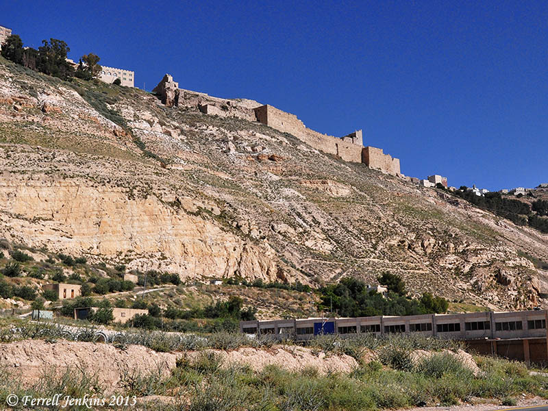
Karak castle from the west side of the ridge on which it stands. Photo by Ferrell Jenkins.

When we travel down the valley toward the Dead Sea, we can turn back toward the east to see Karak castle on the far right of the ridge. Click on the photo for a larger view.

View from the valley below Kir-hareseth. The view is to the east. Photo by Ferrell Jenkins.

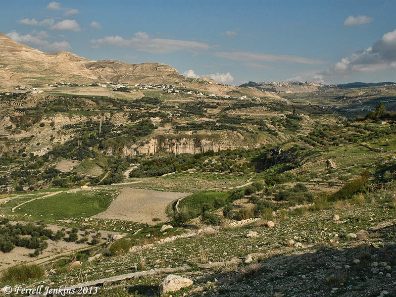
View to the east from the valley below Kir-hareseth. Photo by Ferrell Jenkins.

In the next photo we turn to look down the valley toward the Dead Sea (to the west).

View toward the west from below the Kerak castle. Photo by Ferrell Jenkins.

View toward the west from below the Karak castle. Photo by Ferrell Jenkins.

After the king of Moab offered his oldest son on the wall of the city, the Israelites departed and returned home.

Then he took his oldest son who was to reign in his place and offered him for a burnt offering on the wall. And there came great wrath against Israel. And they withdrew from him and returned to their own land. (2 Kings 3:27 ESV)

The valley we have shown above would be the most natural route to take back to Israel. Kir-hareseth is almost 3000 feet above sea level; the Dead Sea is about 1300 feet below sea level. Highway 50 follows the valley and dead ends at highway 65 which runs north-south along the east side of the Dead Sea.

Understanding the topography of an event helps a lot.

Karak castle plays a role in the 2005 movie Kingdom of Heaven. I found it fascinating because I had been to many of the Crusader sites mentioned in it.

Excavating at Ashkelon – and other places

My friends Trent and Rebekah, participating in the archaeological dig at Ashkelon this summer, have posted a survey of the history of Ashkelon in two parts. In their most recent post which they call “Archaeology 101” they answer some of the common questions they received from acquaintances as they began this project.

Ashkelon is known best to many of us as a Philistine city (1 Samuel 6:17). Trent and Rebekah show us some pottery sherds typical of the period of the Philistines.

Examples of Philistine Pottery Sherds (Left to Right): Philistine Monochrome, Cypriot Milk Jar, another Cypriot Milk Jar, Monochrome Bell Jar Rim and Handle. Photo: Trent and Tebekah

Examples of Philistine Pottery Sherds (Left to Right): Philistine Monochrome, Cypriot Milk Jar, another Cypriot Milk Jar, Monochrome Bell Jar Rim and Handle. Photo: Trent and Tebekah

They explain how their understanding changes as they work at Ashkelon:

Before your eyes, the Philistines transform from the wicked, Samson-hating enemies of Israel to a sophisticated and powerful people–who were also Israel’s enemies.

The tool used by the archaeologist are fascinating to the uninitiated who expect to see a bulldozer and a bull whip. Here are the tools typically found in a square.

Tools of the Trade (Back): Turia, Pickaxe, Brush and Dustpan, (Front) Trowel, Patich, Pottery Bucket. Photo: Trent and Rebekah.

Tools of the Trade (Back): Turia, Pickaxe, Brush and Dustpan, (Front) Trowel, Patiche, Pottery Bucket. Photo: Trent and Rebekah.

Read all about it, and see more photos, at TrentandRebekah.wordpress.com.

Trent and Rebekah were able to meet up yesterday with another friend of mine, Luke Chandler, and (re)visit En Gedi, Dead Sea, and Masada. Luke is working at the Shephelah site of Khirbet Qeiyafa.

I wish the excavation directors at Ashkelon and Khirbet Qeiyafa provided a web site with a few updates on their activities.

Meanwhile, at Tell es-Safi/Gath, Professor Aren Maeir does the best job of anyone I know to keep interested readers informed, and create excitement about archaeology and the dig at Gath. Take a look at his posts during the first week of work at the site. Notice the excitement in the faces of those students who have found a basalt mortar and a bead.

Following the news in the Bible World

Beginning with the Six Day War (June 5-10, 1967) I have tried to keep alert to the situation in the countries that are often called the Bible lands or the Bible World. This phrase is given to the countries of Iran, Iraq, Turkey, Syria, Lebanon, Jordan, Israel, Egypt, Greece, et al. where the events of the Bible transpired. Over the past 47 years I have traveled in all of these countries, some extensively, except Iran.

The current news coming out of Egypt is not good, and it is sad to see the conditions there. I wish for peace and justice for the people of Egypt, and the other countries mentioned above. I wish it also for those who would like to travel to these ancient lands to better learn the history, both secular and biblical.

A scene on the Nile River in Upper Egypt. Photo by Ferrell Jenkins.

A scene on the Nile River in Upper Egypt. Photo by Ferrell Jenkins.

The photo above was made from the Nile River in Upper Egypt, near the ancient town of Edfu. When I look at it I am reminded of the Genesis account of the seven lean cows and seven plump cows that Joseph saw coming up out of the Nile (Genesis 41).

Do we have archaeological evidence the tabernacle was at Shiloh?

During the midst of the allocation of the land to the various tribes of Israel, all of them gathered at Shiloh (Shilo) and set up the tent of meeting or tabernacle (Hebrew mishkan) (Joshua 18:1), which is also called the house of God in Joshua 18:31. Here they made the final division of the land (Joshua 18:8-10).

Then the whole congregation of the people of Israel assembled at Shiloh and set up the tent of meeting there. The land lay subdued before them. (Joshua 18:1 ESV)

Several Israeli newspapers are reporting  a brief notice that archaeologists have discovered holes in the ground at Shiloh which could have held the beams of the Tabernacle. The account in Israel Hayom (Tuesday July 2) is found here.

The findings, which will be presented at a conference of the Shiloh Association scheduled to take place this week in ancient Shiloh, include the discovery of holes carved into the ground which could have held the beams of a temporary structure.

I have visited Tel Shiloh three times in the past five years. The area where the tabernacle is thought to have stood looked this way in May of this year. It was difficult to see what archaeological work was being done. Some of the area looked more like reconstruction.

Area where the tabernacle is thought to have stood at Shiloh. Photo by Ferrell Jenkins, May 2013.

Area where the tabernacle is thought to have stood. Photo by Ferrell Jenkins, May 2013.

Below is a photo of the tabernacle in the wilderness in the park at Timna, a few miles north of Eilat.

The tabernacle in the wilderness at Timna. Photo by Ferrell Jenkins.

The tabernacle in the wilderness at Timna. Photo by Ferrell Jenkins.

We await more information.

There is a web site devoted to Tel Shiloh, but it needs to be updated.

HT: Joseph I. Lauer

Samson mosaics discovered at Huqoq

A Late Roman (fifth century) synagogue is being excavated at Huqoq a few miles northwest of the Sea of Galilee under the direction of Jodi Magness of the University of North Carolina and Shua Kisilevitz of the Israel Antiquities Authority.

The University of North Carolina News reports on the discovery here.

Last summer, a mosaic showing Samson and the foxes (as related in the Bible’s Judges 15:4) was discovered in the synagogue’s east aisle. This summer, another mosaic was found that shows Samson carrying the gate of Gaza on his shoulders (Judges 16:3). Adjacent to Samson are riders with horses, apparently representing Philistines.Although he is not described as such in the Hebrew Bible, Samson is depicted as a giant in both scenes, reflecting later Jewish traditions that developed about the biblical judge and hero.

Samson carrying the gate of Gaza. Discovered at Huqoq.

Mosaic showing Samson carrying the gate of Gaza. Discovered at Huqoq. Photo by Jim Haberman, University of North Carolina.

The book of Judges records the visit of Samson to Gaza, one of the cities of the Philistines. Samson’s conduct is not exemplary. When the Gazites laid a plan to kill him, he carries out his own plan.

 But Samson lay till midnight, and at midnight he arose and took hold of the doors of the gate of the city and the two posts, and pulled them up, bar and all, and put them on his shoulders and carried them to the top of the hill that is in front of Hebron. (Judges 16:3 ESV)

The mosaics from Huqoq illustrate that the members of the synagogue there knew the exploits of Samson.

HT: Joseph I. Lauer

Drainage channel provides evidence of Roman siege of Jerusalem

The Israel Antiquities Authority announced today that “three complete cooking pots and a small ceramic lamp were uncovered in a small cistern in a drainage channel that runs from the Shiloah [Siloam] Pool … to Robinson’s Arch.”

Cooking pots and lamp found in drainage channel near Robinson's Arch, Jerusalem. IAA Photo by Vladimir Naykhin.

Cooking pots and lamp found in a cistern in a drainage channel near Robinson’s Arch, Jerusalem. IAA Photo by Vladimir Naykhin.

According to archaeologist Eli Shukron, “This is the first time we are able to connect archaeological finds with the famine that occurred during the siege of Jerusalem at the time of the Great Revolt. The complete cooking pots and ceramic oil lamp indicate that the people went down into the cistern where they secretly ate the food that was contained in the pots, without anyone seeing them, and this is consistent with the account provided by Josephus.”

The news release sites one of the comments by Josephus in The Jewish War about “the dire hunger that prevailed in the blockaded city.” The suggestion is that some of the people cooked and ate their meals in the drainage system as they were hiding from danger.

The complete news release may be read here.

A portion of the drainage channel that runs from the southwest corner of the Temple Mount to the Pool of Siloam. Photo by Ferrell Jenkins.

A portion of the drainage channel that runs from the southwest corner of the Temple Mount to the Pool of Siloam. Photo by Ferrell Jenkins.

Read more here about the drainage channel which my group walked through May 7, 2010.

HT: Joseph I. Lauer

Roman road found in Jerusalem

A section of the Roman road that led from Joppa to Jerusalem has been found in the Beit Hanina community northeast of the Old City of Jerusalem. This road came to light during preparation for the installation of a drainage pipe.

The road is about 25 feet wide and is said to date back about 1800 years.

Roman road excavated in the Beit Hanina community. Photo: Assaf Peretz, courtesy of the Israel Antiquities Authority.

Roman road excavated in the Beit Hanina community. Photo: Assaf Peretz, courtesy of the Israel Antiquities Authority.

The IAA press release, available here, gives attention the course of the road from Joppa (Yafo) and Jerusalem.

The road section discovered in the IAA excavations in Beit Hanina is part of the imperial network of roads that led to Jerusalem from the coastal plain. We know about these roads from both historical sources and archaeological excavations. Two main arteries led from Yafo to Jerusalem during the Roman period. One is the road that passes through Bet Horon and the other runs via Shaar HaGai. This particular segment belongs to the Bet Horon road. The road began in Yafo and passed through Lod where it split it two different directions: one to Shaar HaGai and the other by way of Modiin along the route of what is today Highway 443 to Bet Horon. From there the road continued eastward as far as Bir Nabala and turned south to Kefar Shmuel where it merged with the highlands road that led to the Old City of Jerusalem.

The Times of Israel includes a map here showing the location of the uncovered section of road.

HT: Joseph Lauer

The traditional site of Dalmanutha

Many tourists stop at Tabgha (Seven Springs, or Heptapegon) to see the mosaic of loaves and fish in the new Church of the Multiplication of the Loaves and Fishes. This church was built in 1982, but we know that a chapel was built at the site as early as the 4th century A.D. I will not engage in a discussion of whether this is the correct location for the feeding of the multitudes by Jesus.

Rarely does anyone have the opportunity to take the path from the church to the lake shore. This is private property. In the photo below, first notice that the water level is low. The green growth is covered when the water level is high. Notice also a path in the middle of the photos. This path leads from the church to the lake (when the water is high).

Traditional site of Dalmanutha (east of Tabgha). Photo by Ferrell Jenkins.

Traditional site of Dalmanutha (east of Tabgha). Photo by Ferrell Jenkins.

Only twice have I been able to reach the lake shore at this point. As one approaches the water there is a sign with the word Dalmanutha on it. I met Bargil Pixner in the book shop of the church in 1994 and have an inscribed copy of his with Jesus through Galilee according to the fifth Gospel. At least once in the book he mentions the Seven Springs as Ma-gadan, Tabgha (p. 37). The enlarged map in the back of the book marks the area as Ma-gadan (Dalmanutha).

Dalmanutha sign in 1994. Photo by Ferrell Jenkins.

Sign at traditional site of Dalmanutha in 1994. Photo by Ferrell Jenkins.

Sign at traditional site of Dalmanutha. Photo by Ferrell Jenkins.

Sign at traditional site of Dalmanutha in 2009. Photo by Ferrell Jenkins.

Here is the view from “Dalmanutha” toward Mount Arbel and the Horns of Hattin.

View from Dalmanutha toward Mount Arbel. Photo by Ferrell Jenkins 1994.

View from traditional Dalmanutha toward Mount Arbel. Photo by Ferrell Jenkins 1994.

I doubt that this identification is correct but thought it was significant enough to pass along.

We pointed out in a previous post here that Dalmanutha is mentioned only once in the Gospels.

And immediately he got into the boat with his disciples and went to the district of Dalmanutha. (Mark 8:10 ESV)

The parallel account in Matthew 15:32-39 says that Jesus came to the region of Magadan.

And after sending away the crowds, he got into the boat and went to the region of Magadan.  (Matthew 15:39 ESV)

In search of Dalmanutha

After the feeding of the four thousand, Jesus went to the district of Dalmanutha.

And immediately he got into the boat with his disciples and went to the district of Dalmanutha. (Mark 8:10 ESV)

This is the only Biblical reference to a place called Dalmanutha. Where was it? When we read the parallel account in Matthew 15:32-39, we learn that Jesus came to the region of Magadan.

And after sending away the crowds, he got into the boat and went to the region of Magadan.  (Matthew 15:39 ESV)

Todd Bolen, at Bible Places Blog, notes that some scholars equate Dalmanutha with Magadan/Magdala. He says,

Mendel Nun has proposed that Dalmanutha be identified with a small anchorage north of Magdala (Anchor Bible Dictionary 2:4). Dalmanutha may not be a proper name but simply the Aramaic word for harbor.

In an article on “Ancient Harbors Of The Sea Of Galilee,” Gordon Franz discusses the location of Magdala/Dalmanutha. Perhaps Dalmanutha “is a transliteration of the Syrian word for harbor.” Or, the term may derive from the harbor that existed here. Franz describes the harbor:

It consisted of two parts; an open dock for loading and unloading during the summer, and a basin, with a 70 m breakwater to protect the ships from the winter storms. (Bible and Spade (1991) Volume 4, 04. p. 120.)

This new discussion about Dalmanutha has been prompted by a recent lecture by Dr. Ken Dark at the Centre for the Study of Christian Origins in the School of Divinity, University of Edinburgh. Helen Bond reports here that Dark spoke of mapping the area around Nazareth and the Sea of Galilee. Notice the summary of Dark’s comments on Dalmanutha:

A new research project is synthesising existing data and using air- and satellite-photography to re-examine the area, combined with the first extensive archaeological survey of the Ginosar valley. The latter has identified a very large, but previously-unrecognised, Late Hellenistic, Roman-period, and later, settlement between the modern town of Migdal (on the western side of the valley) and the coast, just south of Kibbutz Ginosar.  It is hard to imagine that a Roman-period coastal community of this size is nowhere mentioned in textual sources, and the site might be identified with one of the unlocated toponyms known from the Bible, perhaps the Dalmanutha of Mark 8:10.

The aerial photo below shows the general area under consideration. Magdala is on the left of the photo. On the right you can see the museum at Nof Ginosaur where the Roman Boat is shown. Part of the building is hidden behind the wing strut of the airplane.

Aerial view of the Plain of Genessaret from Magdala on the south (left) to Nof Ginosaur on the north (right). Photo by Ferrell Jenkins.

Aerial view of the Plain of Genessaret from Magdala on the south (left) to Nof Ginosaur on the north (right). Photo by Ferrell Jenkins.

The green strip between the water and the land is covered by water this year. You see two places where the growth has been cleared away to make room for a beach.

So, we have several options for the location or meaning of Dalmanutha. In a post to follow I will show you the traditional site of Dalmanutha.

HT: Bible Places Blog; Larry Hurtado’s Blog

Calf and sanctuary found at Ashkelon

Professor Lawrence E. Stager of Harvard writes about the discovery of the silver calf at Ashkelon in the summer of 1990.

In the waning days of the season, on the outskirts of the Canaanite city, we excavated an exquisitely crafted statuette of a silver calf, a religious icon associated with the worship of El or Baal in Canaan and, later, with the Israelite God, Yahweh. The calf lay buried in the debris on the ancient rampart that had protected the city in the Middle Bronze Age (c. 2000–1550 B.C.). (BAR 17:02 (March/April 1991), ed. Hershel Shanks (Biblical Archaeology Society, 1991).

In Life in Biblical Israel, by King and Stager, the calf is dated “around 1600 B.C.E. (p. 173). This bull calf and the pottery shrine in which it was found is now in the Israel Museum in Jerusalem.

Silver calf and sanctuary found at Ashkelon. Photo by Ferrell Jenkins.

Bronze and silver calf and sanctuary found at Ashkelon. Photo by Ferrell Jenkins.

Bible students recall the golden calf made by Aaron at Mount Sinai (Exodus 32:4).

They made a calf in Horeb and worshiped a metal image. (Psalm 106:19 ESV)

We also know about the golden calves erected by Jeroboam I at Dan and Bethel (1 Kings 12:28-30). In the prophet Hosea we find references to calves in Samaria (8:5-6) and Beth-aven (10:5).

Stager calls attention to a significant reference in Hosea 13:1.

When Ephraim spoke, there was trembling; he was exalted in Israel, but he incurred guilt through Baal and died. And now they sin more and more, and make for themselves metal images, idols skillfully made of their silver, all of them the work of craftsmen. It is said of them, “Those who offer human sacrifice kiss calves!”  (Hosea 13:1-2 ESV)

The discoveries of archaeology often shed light on biblical accounts and help us to see the reality of them.

For a photo of a bull from the Samaria region, see here.