
A recent article (here) in the York [Pennsylvania] Daily Record features the research of Messiah College professor Dr. Michael Cosby. Cosby received a Fulbright Grant to do this research in Cyprus, a place associated with the life of Barnabas.
Barnabas is best known to most of us because of his association with the Apostle Paul on the first missionary journey. He is mentioned more than 20 times in the Book of Acts. Other than that, he is mentioned 3 times in Galatians 2, and once each in 1 Corinthians and Colossians.
We understand from Luke’s account that Barnabas, also known as Joseph, was a Levite of Cyprus (Acts 4:36). The first stop on the First Journey was at Salamis on the eastern end of the Mediterranean island of Cyprus (Acts 13:1-5). There the preachers spoke in the synagogue of the Jews, and later on the western end of the island at Paphos.
When Paul and Barnabas had a dispute prior to the Second Journey, Barnabas took his cousin Mark and went to Cyprus (Acts 15:36-41).
Nothing else is mentioned in the Bible about Barnabas and the island of Cyprus. But a great amount of tradition has grown up on the island. It is this tradition that Prof. Cosby studied, and he researched the association of the tradition to the modern Greek Orthodox Church of Cyprus, and the privileges granted to the Cypriot archbishops.
Having just visited Cyprus last year I find this a fascinating article. Perhaps you will enjoy it.
According to a tradition dating back to 488 A.D., the sepulcher of Barnabas was discovered by Anthemios, the Archbishop of Constantia and placed in a church he built near the tomb. The photo below shows the now-empty church near the ruins of Roman Salamis.
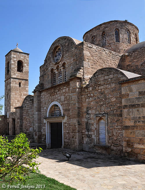
The Church of Barnabas at Salamis. Photo by Ferrell Jenkins.
Salamis is now located in the the Turkish Republic of Northern Cyprus, or as the folks in the south of Cyprus say, “the occupied territory.”


You must be logged in to post a comment.