Category Archives: Bible Places

Following the news in the Bible World

Beginning with the Six Day War (June 5-10, 1967) I have tried to keep alert to the situation in the countries that are often called the Bible lands or the Bible World. This phrase is given to the countries of Iran, Iraq, Turkey, Syria, Lebanon, Jordan, Israel, Egypt, Greece, et al. where the events of the Bible transpired. Over the past 47 years I have traveled in all of these countries, some extensively, except Iran.

The current news coming out of Egypt is not good, and it is sad to see the conditions there. I wish for peace and justice for the people of Egypt, and the other countries mentioned above. I wish it also for those who would like to travel to these ancient lands to better learn the history, both secular and biblical.

A scene on the Nile River in Upper Egypt. Photo by Ferrell Jenkins.

A scene on the Nile River in Upper Egypt. Photo by Ferrell Jenkins.

The photo above was made from the Nile River in Upper Egypt, near the ancient town of Edfu. When I look at it I am reminded of the Genesis account of the seven lean cows and seven plump cows that Joseph saw coming up out of the Nile (Genesis 41).

Do we have archaeological evidence the tabernacle was at Shiloh?

During the midst of the allocation of the land to the various tribes of Israel, all of them gathered at Shiloh (Shilo) and set up the tent of meeting or tabernacle (Hebrew mishkan) (Joshua 18:1), which is also called the house of God in Joshua 18:31. Here they made the final division of the land (Joshua 18:8-10).

Then the whole congregation of the people of Israel assembled at Shiloh and set up the tent of meeting there. The land lay subdued before them. (Joshua 18:1 ESV)

Several Israeli newspapers are reporting  a brief notice that archaeologists have discovered holes in the ground at Shiloh which could have held the beams of the Tabernacle. The account in Israel Hayom (Tuesday July 2) is found here.

The findings, which will be presented at a conference of the Shiloh Association scheduled to take place this week in ancient Shiloh, include the discovery of holes carved into the ground which could have held the beams of a temporary structure.

I have visited Tel Shiloh three times in the past five years. The area where the tabernacle is thought to have stood looked this way in May of this year. It was difficult to see what archaeological work was being done. Some of the area looked more like reconstruction.

Area where the tabernacle is thought to have stood at Shiloh. Photo by Ferrell Jenkins, May 2013.

Area where the tabernacle is thought to have stood. Photo by Ferrell Jenkins, May 2013.

Below is a photo of the tabernacle in the wilderness in the park at Timna, a few miles north of Eilat.

The tabernacle in the wilderness at Timna. Photo by Ferrell Jenkins.

The tabernacle in the wilderness at Timna. Photo by Ferrell Jenkins.

We await more information.

There is a web site devoted to Tel Shiloh, but it needs to be updated.

HT: Joseph I. Lauer

Drainage channel provides evidence of Roman siege of Jerusalem

The Israel Antiquities Authority announced today that “three complete cooking pots and a small ceramic lamp were uncovered in a small cistern in a drainage channel that runs from the Shiloah [Siloam] Pool … to Robinson’s Arch.”

Cooking pots and lamp found in drainage channel near Robinson's Arch, Jerusalem. IAA Photo by Vladimir Naykhin.

Cooking pots and lamp found in a cistern in a drainage channel near Robinson’s Arch, Jerusalem. IAA Photo by Vladimir Naykhin.

According to archaeologist Eli Shukron, “This is the first time we are able to connect archaeological finds with the famine that occurred during the siege of Jerusalem at the time of the Great Revolt. The complete cooking pots and ceramic oil lamp indicate that the people went down into the cistern where they secretly ate the food that was contained in the pots, without anyone seeing them, and this is consistent with the account provided by Josephus.”

The news release sites one of the comments by Josephus in The Jewish War about “the dire hunger that prevailed in the blockaded city.” The suggestion is that some of the people cooked and ate their meals in the drainage system as they were hiding from danger.

The complete news release may be read here.

A portion of the drainage channel that runs from the southwest corner of the Temple Mount to the Pool of Siloam. Photo by Ferrell Jenkins.

A portion of the drainage channel that runs from the southwest corner of the Temple Mount to the Pool of Siloam. Photo by Ferrell Jenkins.

Read more here about the drainage channel which my group walked through May 7, 2010.

HT: Joseph I. Lauer

Roman road found in Jerusalem

A section of the Roman road that led from Joppa to Jerusalem has been found in the Beit Hanina community northeast of the Old City of Jerusalem. This road came to light during preparation for the installation of a drainage pipe.

The road is about 25 feet wide and is said to date back about 1800 years.

Roman road excavated in the Beit Hanina community. Photo: Assaf Peretz, courtesy of the Israel Antiquities Authority.

Roman road excavated in the Beit Hanina community. Photo: Assaf Peretz, courtesy of the Israel Antiquities Authority.

The IAA press release, available here, gives attention the course of the road from Joppa (Yafo) and Jerusalem.

The road section discovered in the IAA excavations in Beit Hanina is part of the imperial network of roads that led to Jerusalem from the coastal plain. We know about these roads from both historical sources and archaeological excavations. Two main arteries led from Yafo to Jerusalem during the Roman period. One is the road that passes through Bet Horon and the other runs via Shaar HaGai. This particular segment belongs to the Bet Horon road. The road began in Yafo and passed through Lod where it split it two different directions: one to Shaar HaGai and the other by way of Modiin along the route of what is today Highway 443 to Bet Horon. From there the road continued eastward as far as Bir Nabala and turned south to Kefar Shmuel where it merged with the highlands road that led to the Old City of Jerusalem.

The Times of Israel includes a map here showing the location of the uncovered section of road.

HT: Joseph Lauer

The traditional site of Dalmanutha

Many tourists stop at Tabgha (Seven Springs, or Heptapegon) to see the mosaic of loaves and fish in the new Church of the Multiplication of the Loaves and Fishes. This church was built in 1982, but we know that a chapel was built at the site as early as the 4th century A.D. I will not engage in a discussion of whether this is the correct location for the feeding of the multitudes by Jesus.

Rarely does anyone have the opportunity to take the path from the church to the lake shore. This is private property. In the photo below, first notice that the water level is low. The green growth is covered when the water level is high. Notice also a path in the middle of the photos. This path leads from the church to the lake (when the water is high).

Traditional site of Dalmanutha (east of Tabgha). Photo by Ferrell Jenkins.

Traditional site of Dalmanutha (east of Tabgha). Photo by Ferrell Jenkins.

Only twice have I been able to reach the lake shore at this point. As one approaches the water there is a sign with the word Dalmanutha on it. I met Bargil Pixner in the book shop of the church in 1994 and have an inscribed copy of his with Jesus through Galilee according to the fifth Gospel. At least once in the book he mentions the Seven Springs as Ma-gadan, Tabgha (p. 37). The enlarged map in the back of the book marks the area as Ma-gadan (Dalmanutha).

Dalmanutha sign in 1994. Photo by Ferrell Jenkins.

Sign at traditional site of Dalmanutha in 1994. Photo by Ferrell Jenkins.

Sign at traditional site of Dalmanutha. Photo by Ferrell Jenkins.

Sign at traditional site of Dalmanutha in 2009. Photo by Ferrell Jenkins.

Here is the view from “Dalmanutha” toward Mount Arbel and the Horns of Hattin.

View from Dalmanutha toward Mount Arbel. Photo by Ferrell Jenkins 1994.

View from traditional Dalmanutha toward Mount Arbel. Photo by Ferrell Jenkins 1994.

I doubt that this identification is correct but thought it was significant enough to pass along.

We pointed out in a previous post here that Dalmanutha is mentioned only once in the Gospels.

And immediately he got into the boat with his disciples and went to the district of Dalmanutha. (Mark 8:10 ESV)

The parallel account in Matthew 15:32-39 says that Jesus came to the region of Magadan.

And after sending away the crowds, he got into the boat and went to the region of Magadan.  (Matthew 15:39 ESV)

In search of Dalmanutha

After the feeding of the four thousand, Jesus went to the district of Dalmanutha.

And immediately he got into the boat with his disciples and went to the district of Dalmanutha. (Mark 8:10 ESV)

This is the only Biblical reference to a place called Dalmanutha. Where was it? When we read the parallel account in Matthew 15:32-39, we learn that Jesus came to the region of Magadan.

And after sending away the crowds, he got into the boat and went to the region of Magadan.  (Matthew 15:39 ESV)

Todd Bolen, at Bible Places Blog, notes that some scholars equate Dalmanutha with Magadan/Magdala. He says,

Mendel Nun has proposed that Dalmanutha be identified with a small anchorage north of Magdala (Anchor Bible Dictionary 2:4). Dalmanutha may not be a proper name but simply the Aramaic word for harbor.

In an article on “Ancient Harbors Of The Sea Of Galilee,” Gordon Franz discusses the location of Magdala/Dalmanutha. Perhaps Dalmanutha “is a transliteration of the Syrian word for harbor.” Or, the term may derive from the harbor that existed here. Franz describes the harbor:

It consisted of two parts; an open dock for loading and unloading during the summer, and a basin, with a 70 m breakwater to protect the ships from the winter storms. (Bible and Spade (1991) Volume 4, 04. p. 120.)

This new discussion about Dalmanutha has been prompted by a recent lecture by Dr. Ken Dark at the Centre for the Study of Christian Origins in the School of Divinity, University of Edinburgh. Helen Bond reports here that Dark spoke of mapping the area around Nazareth and the Sea of Galilee. Notice the summary of Dark’s comments on Dalmanutha:

A new research project is synthesising existing data and using air- and satellite-photography to re-examine the area, combined with the first extensive archaeological survey of the Ginosar valley. The latter has identified a very large, but previously-unrecognised, Late Hellenistic, Roman-period, and later, settlement between the modern town of Migdal (on the western side of the valley) and the coast, just south of Kibbutz Ginosar.  It is hard to imagine that a Roman-period coastal community of this size is nowhere mentioned in textual sources, and the site might be identified with one of the unlocated toponyms known from the Bible, perhaps the Dalmanutha of Mark 8:10.

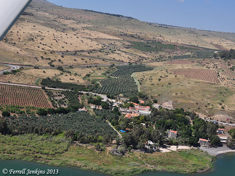
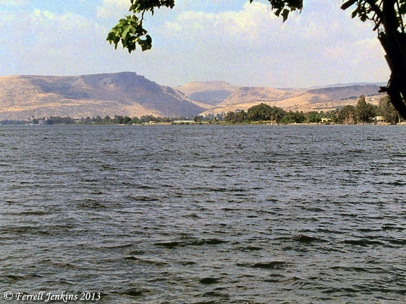
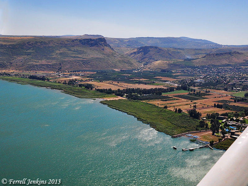
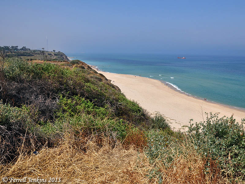
The aerial photo below shows the general area under consideration. Magdala is on the left of the photo. On the right you can see the museum at Nof Ginosaur where the Roman Boat is shown. Part of the building is hidden behind the wing strut of the airplane.

Aerial view of the Plain of Genessaret from Magdala on the south (left) to Nof Ginosaur on the north (right). Photo by Ferrell Jenkins.

Aerial view of the Plain of Genessaret from Magdala on the south (left) to Nof Ginosaur on the north (right). Photo by Ferrell Jenkins.

The green strip between the water and the land is covered by water this year. You see two places where the growth has been cleared away to make room for a beach.

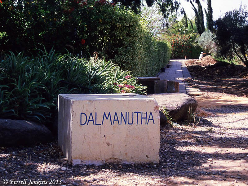
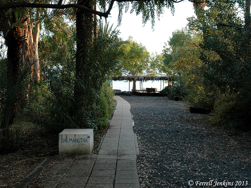
So, we have several options for the location or meaning of Dalmanutha. In a post to follow I will show you the traditional site of Dalmanutha.

HT: Bible Places Blog; Larry Hurtado’s Blog

Calf and sanctuary found at Ashkelon

Professor Lawrence E. Stager of Harvard writes about the discovery of the silver calf at Ashkelon in the summer of 1990.

In the waning days of the season, on the outskirts of the Canaanite city, we excavated an exquisitely crafted statuette of a silver calf, a religious icon associated with the worship of El or Baal in Canaan and, later, with the Israelite God, Yahweh. The calf lay buried in the debris on the ancient rampart that had protected the city in the Middle Bronze Age (c. 2000–1550 B.C.). (BAR 17:02 (March/April 1991), ed. Hershel Shanks (Biblical Archaeology Society, 1991).

In Life in Biblical Israel, by King and Stager, the calf is dated “around 1600 B.C.E. (p. 173). This bull calf and the pottery shrine in which it was found is now in the Israel Museum in Jerusalem.

Silver calf and sanctuary found at Ashkelon. Photo by Ferrell Jenkins.

Bronze and silver calf and sanctuary found at Ashkelon. Photo by Ferrell Jenkins.

Bible students recall the golden calf made by Aaron at Mount Sinai (Exodus 32:4).

They made a calf in Horeb and worshiped a metal image. (Psalm 106:19 ESV)

We also know about the golden calves erected by Jeroboam I at Dan and Bethel (1 Kings 12:28-30). In the prophet Hosea we find references to calves in Samaria (8:5-6) and Beth-aven (10:5).

Stager calls attention to a significant reference in Hosea 13:1.

When Ephraim spoke, there was trembling; he was exalted in Israel, but he incurred guilt through Baal and died. And now they sin more and more, and make for themselves metal images, idols skillfully made of their silver, all of them the work of craftsmen. It is said of them, “Those who offer human sacrifice kiss calves!”  (Hosea 13:1-2 ESV)

The discoveries of archaeology often shed light on biblical accounts and help us to see the reality of them.

For a photo of a bull from the Samaria region, see here.

Ashkelon excavation underway

‘Tis the season for archaeological digs. At Ashkelon, the Leon Levy Expedition runs from June 8 – July 19 this year. It is sponsored by Harvard’s Semitic Museum, Boston College, Wheaton College, and Troy University.

I have two young friends, Trent and Rebekah, who are working in the dig. They will not be writing up any marvelous new discoveries that might be made. This is always reserved for the directors of a dig to announce, and then later to publish. My friends are sharing some general information about their participation in the dig as time permits. They are there as part of Dr. Daniel Master’s team from Wheaton College.

Trent has allowed me to use one of his photos of Grid 51. This is the Grid he has been working in during the past week. He informs me that this is about 1/4 mile southwest of the Canaanite Gate, and belongs to the Persian period. At the time Ashkelon was an important port aligned with Tyre and occupied by Phoenicians.

Grid 51 of the current Ashkelon excavation. Photo by Trent Dutton.

Grid 51 of the current Ashkelon excavation. Photo by Trent Dutton.

Notice that the Mediterranean Sea is visible to the west. The photo below shows the view south toward Gaza and Egypt and may include Grid 51.

View south along the beach at Ashkelon. Photo by Ferrell Jenkins.

View south along the beach at Ashkelon. Photo by Ferrell Jenkins.

According to 1 Samuel 6:17 there were five important Philistine cities: Ashdod, Gaza, Ashkelon, Gath, and Ekron. Ashkelon had a long history including occupation by Canaanites, Egyptians, Philistines, Phoenicians, Greeks, Romans, Byzantines, Muslims, Crusaders, and finally by Mamelukes.

If you would like to follow what Trent and Rebekah are able to share, see their blog here.

Overview of Jerusalem from the Haas Promenade

The Haas Promenade is fairly easy to reach from the Hebron Road (Derech Hevron) on the south side of Jerusalem. From there one has a beautiful view of the Old City of Jerusalem and the surrounding area. Those who know the city will enjoy this photo more than those who do not.

View of Jerusalem from the Haas Promenade. Photo by Ferrell Jenkins.

View of Jerusalem from the Haas Promenade. Photo by Ferrell Jenkins.

In this photo you can see the entirety of the southern wall of the Old City. From left to right notice the Church of the Dormition, the Dome of the Rock, the depression of the Kidron Valey, Mount Scopus, and the Mount of Olives. You can see the three towers of Olivet.

Because I have not been posting very much lately, and to show my appreciation for those of you who subscribe and continue to visit the blog, I have linked the image above to one large enough to use in PowerPoint presentations. I hope you and your viewers will enjoy.

As the mountains surround Jerusalem, so the LORD surrounds his people, from this time forth and forevermore. (Psalm 125:2 ESV)

The synagogue — a place of study and discussion

The origin of the synagogue is difficult to determine, but it is generally held that it arose during the time of the Babylonian exile. Synagogues did not become common until the intertestamental period. The term intertestamental is used by many writers to describe the period between the close of the Old Testament (about 425 B.C.) and the coming of John the Baptist in the early first century A.D. Others use the term interbiblical, or the longer phrase, between the testaments.

With the destruction of the Temple (586 B.C.), sacrifices ceased. Prayer and the study of the sacred Scriptures, however knew no geographical limitations. The Book of Ezekiel describes the elders of Israel gathering in the prophet’s house (8:1; 20:1-3) (Charles Pfeiffer, Between the Testaments, 59).

In the sixth year, in the sixth month, on the fifth day of the month, as I sat in my house, with the elders of Judah sitting before me, the hand of the Lord GOD fell upon me there. (Ezekiel 8:1 ESV)

In the seventh year, in the fifth month, on the tenth day of the month, certain of the elders of Israel came to inquire of the LORD, and sat before me. And the word of the LORD came to me: “Son of man, speak to the elders of Israel, and say to them, Thus says the Lord GOD, Is it to inquire of me that you come? As I live, declares the Lord GOD, I will not be inquired of by you. (Ezekiel 20:1-3 ESV)

The word synagogue is of Greek origin. It simply refers to a gathering of the people, or a congregation. “The Hebrew word for such a gathering is keneseth, the name used for the parliament in the modern state of Israel” (Pfeiffer, 59).
After the rebuilding of the Temple (520–516 B.C.), the synagogue continued to fill the spiritual needs of the Jews of the Diaspora. There were synagogues in many of the cities visited by Paul: Damascus (Acts 9:2); Salamis (13:5); Antioch of Pisidia (13:14); Thessalonica (17:1); Corinth (18:4); Ephesus (19:8), and others. Only ten families were needed to compose a synagogue.

In 1898 a partial inscription mentioning a “synagogue of the Hebrews” was found at Corinth. It was published by Benjamin Powell in 1903 and identified as having come from the synagogue where Paul preached. McRay says that further study showed that it should be dated considerably later than the time of Paul. (Archaeology and the New Testament, p. 319).

Synagogue Inscription displayed in Corinth Museum. Photo by Ferrell Jenkins.

Synagogue Inscription displayed in Corinth Museum. Photo by Ferrell Jenkins.

A small plaque mounted underneath the inscription at the Corinth Museum reads, “Inscription from a late Roman synagogue.”

One rabbinic tradition has it that there were 480 synagogues in Jerusalem alone. Even the small villages of Galilee had synagogues at the time of Jesus (Mt. 4:23; 9:35).