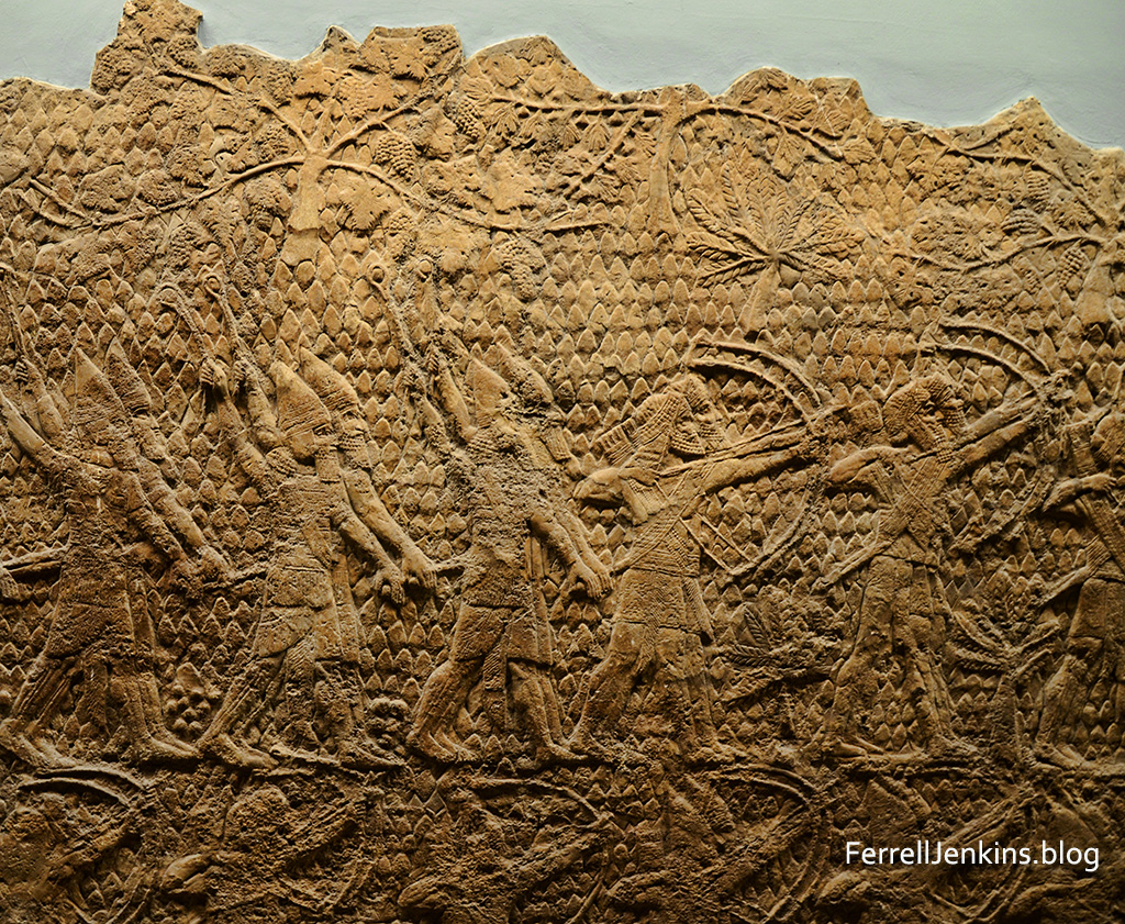
After Sennacherib, king of Assyria (704-681 BC), defeated the Judeans who lived at Lachish he tried to capture Jerusalem but was unsuccessful. Back home in Nineveh the king left a limestone relief of the siege of Lachish on his palace wall. The original is now in the British Museum. There is a replica in the Israel Museum.
The panel below shows the landscape around Lachish with palm trees and vineyards. Here is a small section of the relief. Notice especially the upper left corner of the relief.
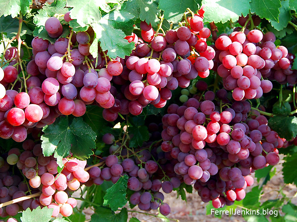
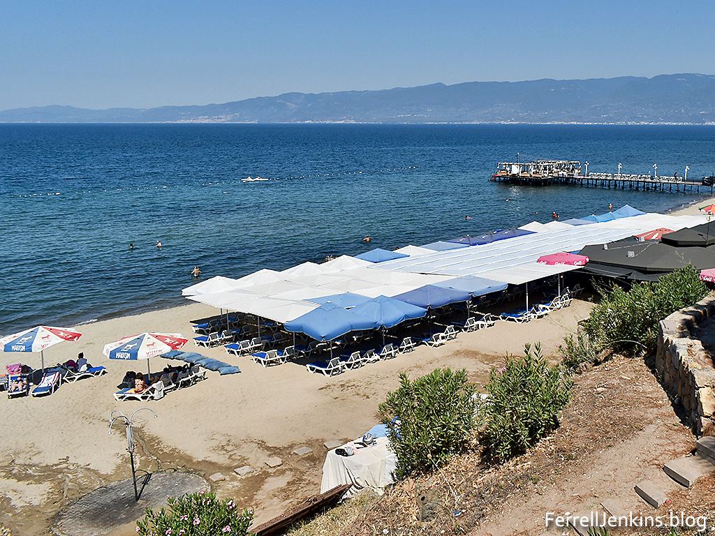
In resettling the land of Biblical Israel, the modern settlers tried to plant the same plants known in Bible times. The Sennacherib relief shows clearly that date palms and vineyards were in abundance in the region. Our next photo which I made in the Lachish area in the month of August shows grapes for eating in abundance.
Click on the images to see a larger photo suitable for use in your teaching.
Today’s photo shows the Mount of Olives from the east. The tall tower on the peak is the traditional place of the ascension of Jesus (Acts 1:9-11).
Luke’s account of the ascension says Jesus took the disciples as far from Jerusalem as Bethany where he was taken up (Luke 24:59-51). Both Bethphage and Bethany are located on the eastern slope of the Mount of Olives. Bethphage is nearest to the tower of ascension with Bethany being a short distance further to the south (left in the photo).
The Mount of Olives is about 200 feet higher in elevation than the ridge on which the city of Jerusalem is built. The city of Jerusalem is not visible from the east until one is on the Olivet ridge, or Mount Scopus further to the north (right). This is the view of the Mount of Olives Jesus and others would have seen when walking from Jericho to Jerusalem.
You may download the photo and use it in your teaching of the Bible. Please maintain our credit logo which shows in the lower right corner.
Only one of the Gospel accounts of the ministry of Jesus records a visit by Jesus to the town of Nain. Strangely it is Luke who wrote two volumes (Luke and Acts of the Apostles) to a man known as Theophilus (Luke 1:3; Acts 1:1).
John, who was a personal eyewitness to the ministry of Jesus, included only seven miraculous signs of Jesus in his gospel. He exaggerated for the sake of emphasis, “Now there are also many other things that Jesus did. Were every one of them to be written, I suppose that the world itself could not contain the books that would be written” (John 21:25 ESV). In addition to the resurrection of Jesus, John included the account of the resurrection of Lazarus in John 11.
I find it intriguing that Luke mentions this account of the resurrection of a young man as his mother was on the way to bury him. Luke was a physician who became what we might call the primary physician of the apostle Paul (Colossians 4:14; 2 Timothy 4:11; see also the “We” sections of Acts where Luke is traveling with Paul.
Scholars have written about the medical language of Luke used in his two volumes.
On our visit to Israel earlier this year I stopped to make a new photo of the town of Nain on the north side of the the Hill of Moreh.
The town of Nain on the northern slopes of the Hill of Moreh.
Adramyttium is mentioned only once in the New Testament. In Acts 27:2 we are informed that the ship used to transport Paul to Rome for his appeal before Caesar was “a ship of Adramyttium” (Acts 27:1-2). Paul continued in this ship as far as Myra in Lycia (Acts 27:5-6) where he was transferred to an Alexandrian ship.
But there is still a chance that Paul stopped at Adramyttium on the return from his second preaching journey. Luke provides us with a detailed account of the stops along the way. He says, “And when he met us at Assos, we took him on board and went to Mitylene. And sailing from there we came the following day opposite Chios; the next day we touched at Samos; and the day after that we went to Miletus” (Acts 20:14-15 ESV).
Notice the reference to Chios. When we check a variety of versions we come up with some interesting results.
The ESV says “we came…opposite Chios.”
ASV, NKJ: “over against Chios”
NAS, NAU: “opposite Chios”
CSB: “off Chios”
NIV, NET: “off Chios”
NLT: “past the island of Kios”
The Greek word used here is antikpus and usually means off or opposite. Mark Wilson suggests that “Paul probably passed near Adramyttium on his second journey to Troas, if the southern route below Mysia is reckoned (Acts 16:8). He also probably passed through the city following his departure from Ephesus while traveling up the coast to Troas (Acts 20:1-2; 2 Corinthians 2:12).” (15
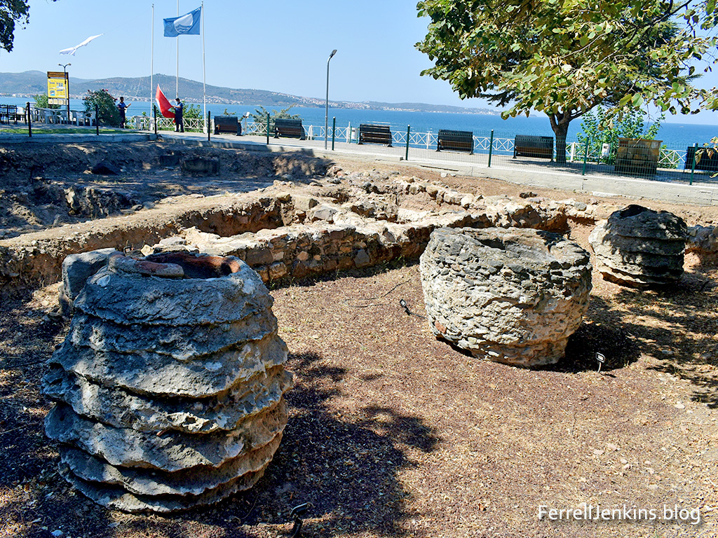
So, whether or not, here is a photo from ancient Adramyttium in the modern Turkish town of Ören in the Mersin district of Turkey.
This area of excavation is under some large trees causing the dark spots in some places.
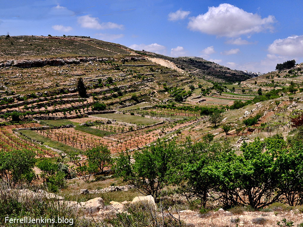
Along the central mountain road between Bethlehem and Hebron. There are many beautiful views. This one shows examples of the continued fertility of the land that was promised to the ancient Israelites. It illustrates the use of valleys to collect water during the rain season to provide water for the plants. The hillsides illustrate the terracing used as far back as the Biblical Iron age (around 1000 B.C.).
View of hillsides and valleys along road between Bethlehem and Hebron. Photo by Ferrell Jenkins.
After the previous post I was ask how far the map extended. I have seen the map several times, but much of my detailed info comes from an article by Victor R. Gold: “The Mosaic Map of Medeba.” This article first appeared in Biblical Archaeologist, XXI.3 (Sept. 1958), pp.59-71. It was included in a 3-volume set called The Biblical Archaeologist Reader, vol. 3.
Here is a section on the extent of the Map:
“Except for the [third century] Tabula Peutingeriana [road map of the world], the Madeba map is the only map of ancient Palestine still in existence. The large remaining section extends from Aenon in the Jordan valley, or near it, in the north, to the Canobic branch of the Nile in the south. Not even this section is complete, however, the footing of one of the columns rests over a section of Judea from Eleutheropolis (Beit Jibin) to Ashdod and Beersheba.” (Campbell, Edward F., and David N. Freedman, editors. The Biblical Archaeologist Reader 3. First ed., vol. 3, Doubleday and Company, 1970, pp. 359-65, 3 vols.
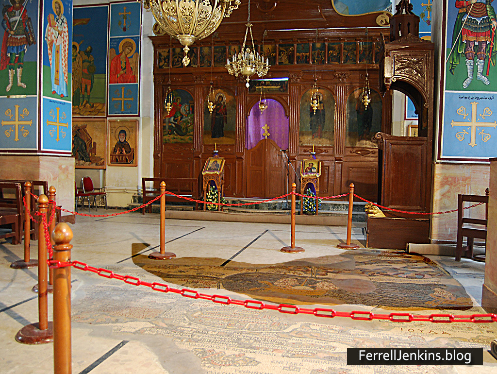
I am including a photo showing the actual size of the map in the church building floor at Madaba, Jordan. I have darkened the portion of the map that has been reconstructed there. We are not seeing all that is known to have existed. I have noted a small portion of the Nile Delta, and coastal towns such as Ashkelon and Ashdod. In my photos I can see mountains of Moab to the east, and Aenon in the northern Jordan Valley.
For the benefit of those who might like to see the size of the map in the Madaba church, I have darkened the map in the area that is cordoned off.
The Madaba Map is shown darker in the church floor to allow one to see the size of the map there.
The Madaba Map is an amazing piece of work. It would be nice if we had one in the vestibule where I meet with Christians.
About AD 560 the church at Madaba, now in Jordan, decided they needed a map in their building. They could not order one from their Bible class publisher, so they made a large Mosaic map on the floor of the building. This map was rediscovered in the 1880s.
Madaba was known as the Ammonite city of Medeba in Joshua 13:9,16 and Isaiah 15:2.
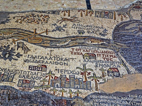
For now I wish to share a photo of a surviving portion showing the Jordan River flowing into the Dead Sea.
I understand the designer of the map to be saying that the fish of the Jordan River could not survive in the Salt Sea. This portion of the map also shows Jericho, the city of Palm trees (Deuteronomy 34:3; 2 Chronicles 28:15).
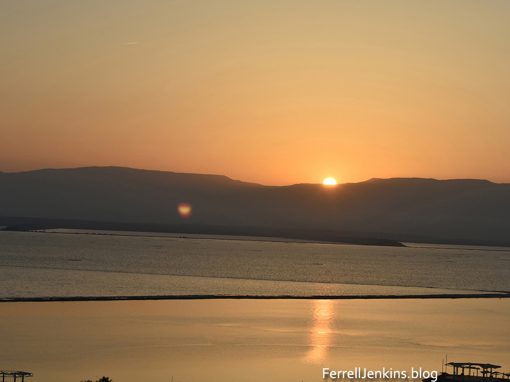
We set the clock to get up in time to see the sunrise across the Dead Sea. I was pleased with the result as the sun rose in the vicinity of Biblical Edom sending a ray across the Dead Sea. The smaller light to the left of center is a reflection from the camera lens.
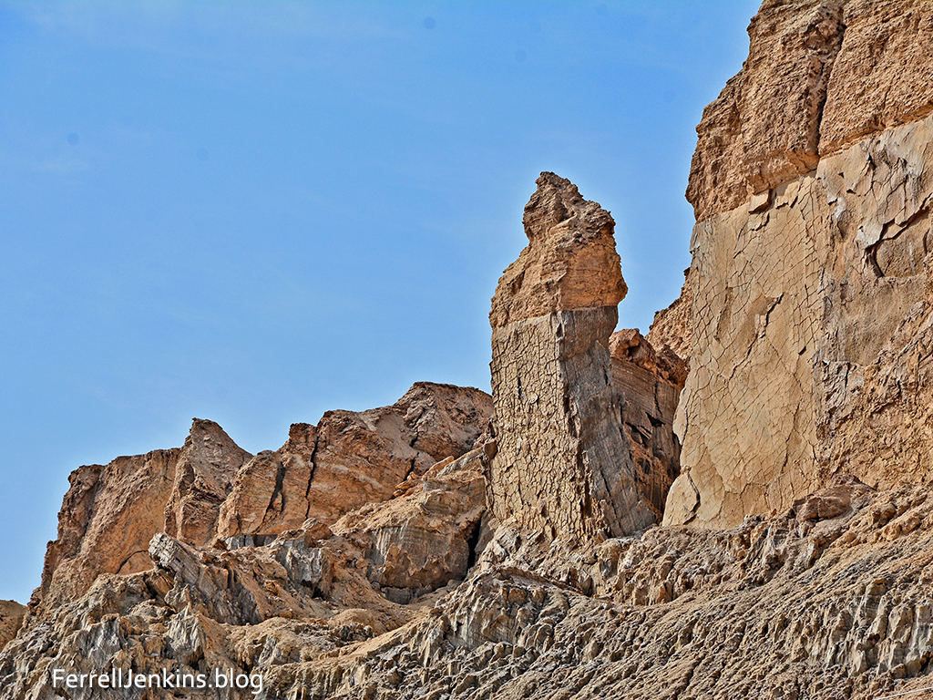
Now Lot went up out of Zoar and lived in the hills with his two daughters, for he was afraid to live in Zoar. So he lived in a cave with his two daughters. (Gen. 19:30 ESV)
While we were at the southern end of the Dead Sea we drove a little further south to see the formation nicknamed “Lot’s Wife.” This is based on the Biblical story of the destruction of Sodom and Gomorrah (Genesis 19. See especially Genesis 19:26, and the reference by Jesus in Luke 17:32).
As usual, these photos are available for download for use in teaching as long as credit is given to this source. For commercial use see our Photo Permission page.
The areas of Turkey that have been hit by the 7.8 earthquake are along the East Anatolian Fault. It has been my pleasure to visit many of these cities: Gaziantep, Karaman, and Antakya. Also Aleppo in northern Syria. The areas around Antakya might include the other historical sites of Tel Tayinat and Tel Alalak.
Did you knowthat Antakya was part of Syria until about 1935 when it was annexed as part of Turkey? Antaka is the location of the New Testament site of Antioch of Syria. This was a city where Paul, Peter, and Barnabas worked, and where the disciples of Jesus were first call Christians.
So Barnabas went to aTarsus to look for Saul, 26 and when he had found him, he brought him to Antioch. For a whole year they met with the church and taught a great many people. And in Antioch the disciples were first called aChristians. (Acts 11:25-26 ESV)
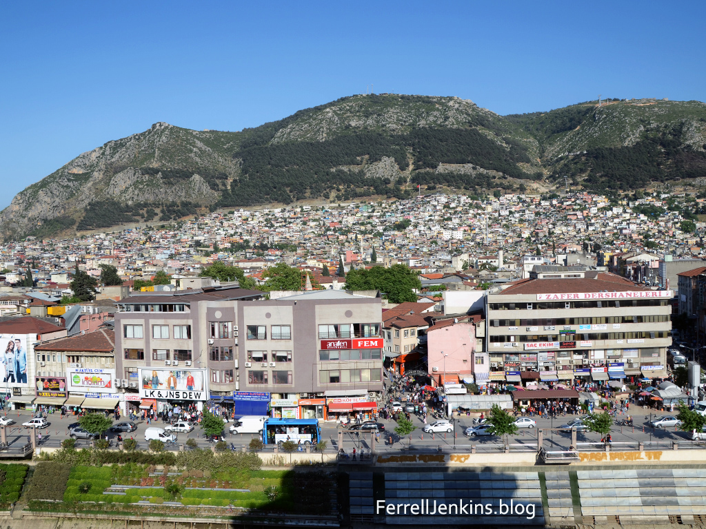
Our photo below shows the city of Antakya built on Mount Silpius along the Orontes River.
Recent readers may not have noticed our header having a link on Indexes (Indices). If you go there you will find an Index of articles on Bethlehem and the Birth of Jesus. At this time of the year when many are thinking about the birth of Jesus and it’s meaning for all mankind I thought it would be good to call attention to these articles and photos. There have been several good comments and discussions about the date of the birth of Jesus.
I have many photos of shepherds and sheep, but not one of shepherds watching their sheep by night in the vicinity of Bethlehem. I do have some photos of shepherds with their sheep in the sheepfold at Heshbon in Jordan. I had been at Heshbon one afternoon visiting with the shepherds and making photos. When I saw their makeshift sheepfold I asked if I could come back in the evening and make some photos. The photo here is one made a dusk after the sheep had been gathered into the sheepfold. The shepherd and his family live in the tent. Heshbon was a former Moabite town given to the tribe of Reuben after the Israelites captured the Trans-Jordan tableland (Numbers 32:37).
Shepherds at Heshbon watching their flock at night.
To access the articles on Bethlehem click through here.


You must be logged in to post a comment.