Category Archives: Bible Lands

Sargon II, Ashdod, and Isaiah 20:1

Ashdod was located along an international highway known as the Way of the Sea, the Way of Philistia, or the Via Maris. This was the important route connecting Egypt and Assyria. We have already discussed, in the past few posts, that the Assyrian king Sargon II captured Ashdod in 712/11 B.C. The prophet Isaiah makes reference to this event in Isaiah 20:1.

 The LORD revealed the following message during the year in which King Sargon of Assyria sent his commanding general to Ashdod, and he fought against it and captured it. (Isa 20:1 NET)

Sometime discoveries are made, but get little attention. A discovery at Tel Ashdod in 1963 falls into this category. Tel Ashdod was excavated from 1962 to 1972 under the direction of Moshe Dothan. David Noel Freedman wrote an article in Biblical Archaeologist (26:4, 1963)) about “The Second Season at Ancient Ashdod.” He describes the fragments of a stele of Sargon II.

Fragments of another stele, commemorating the victories of Sargon, were found at Ashdod during the current season, thus offering direct confirmation and vivid illustration of the biblical and Assyrian accounts. In all, three pieces of the stele were discovered. Enough can be made of their contents to show that the inscription duplicated in content if not precisely in wording other victory steles of the Assyrian king. By comparing the Ashdod stele with the others it will be possible to reconstruct the missing parts, one of which described the actual conquest of Ashdod. The inscription was carved in cuneiform signs characteristic of Sargon and his period, on all four sides of a slab of basalt which had been imported from a region north of Megiddo. It may have served as a pedestal for an obelisk, or a statue of the emperor. It must have been erected between the year of victory at Ashdod and the death of the king in 705 B.C., perhaps in 707 when a similar stele was set up in Cyprus. With the accession of Sennacherib in 704, most of the vessel countries revolted; Hezekiah of Judah and Sidqa of Ashkelon were the ringleaders in the west. They were able to liberate Ashdod from Assyrian control, and doubtless the event was observed by the destruction of Sargon’s victory stele, symbol of foreign oppression. These fragments of a monumental Assyrian inscription are the first ever found in Palestine.

The photos below were published in an article by Hayam Tadmor (“Philistia Under Assyrian Rule.” Biblical Archaeologist (29:3, 1966). Several years ago I used a digital camera to copy the photo. Sorry it is not better, but at least you can see the pieces. A photo of the piece in the middle below is also published in a BAR article (Jan-Feb, 2007) by H. Shanks on the “Assyrian Palace Discovered in Ashdod,” but the quality is about the same.
Fragment of the Sargon II inscription found at Ashdod.

Fragment of the Sargon II inscription found at Ashdod.

For several years the fragments were displayed in a case across from the replica of the Siege of Lachish in the Israel Museum. For the past years the fragments have not been on display. I made inquiry at the Museum earlier this year without any success. I wonder if the pieces have been moved to the Corine Maman Museum of Philistine Culture in Ashdod. Can anyone help with this?

This discovery is one of those that complement the biblical record. Sargon II (721–705 B.C.) is mentioned only once in the Bible — Isaiah 20:1. Isaiah says that the commanding general of Sargon II fought against Ashdod and captured it.

The photo below shows Sargon II (right) facing a person who is generally considered to be an Assyrian high dignitary. (See the discussion in Fant & Reddish, Lost Treasures of the Bible, 133-140.

Sargon II and an attendant. Displayed in Louvre. Photo by Ferrell Jenkins.

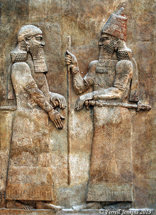
Sargon II and an official. Displayed in Louvre. Photo by Ferrell Jenkins.

Jack Finegan says of the reference to Sargon II in Isaiah 20:1,

… for a long time this was the only place in extant literature where his name was known.

The palace of Sargon II was discovered by Paul Emile Botta at Khorsabad in 1843. This relief comes from that palace, and is displayed in the Louvre. Other reliefs and artifacts from the palace are exhibited in the British Museum and the Oriental Institute of the University of Chicago.

Written copies of Isaiah existed in what we know as the Dead Sea Scrolls nearly 2000 years before the discovery of Sargon’s palace and archive. Perhaps we should be slow to think of Isaiah and other biblical writers as being unhistorical. To say this in a positive way, this illustrates the historical trustworthiness of the Bible. That the only reference to Sargon is specifically linked to Ashdod is even more impressive.

The Philistine city of Ashdod in the Bible

Ashdod is mentioned in the Bible as one of five cities of the Philistine Pentapolis (1 Samuel 6:17). The city is mentioned earlier among the Canaanite cities in the Ebla tablets. Here is a brief survey of the events recorded in the Bible.

  • Some of the Anakim were left in Gaza, Gath, and Ashdod after Israel entered the land (Joshua 11:22).
  • Ashdod was among some cities that remained under Philistine control even though it had been assigned to the tribe of Judah (Joshua 13:2-3; 15:46-47).
  • When Israel lost the Ark of the Covenant at Ebenezer, the Philistines brought it to Ashdod and placed it in the temple of Dagon (1 Samuel 5:1-8).
Representation of the Ark of the Covenant in the Tabernacle in the Wilderness at Timna. Photo by Ferrell Jenkins.

Representation of the Ark of the Covenant in the Tabernacle in the Wilderness at Timna.

  • Uzziah, king of Judah (767-740/39 B.C.), made war against Ashdod. He broke down the wall of Ashdod and built cities in the area (2 Chronicles 26:6).
  • King Sargon II of Assyria captured Ashdod in 712/711 B.C. (Isaiah 20:1).
  • After the return from Babylon, Nehemiah faced problems because some of the Judeans had married women of Ashdod. Their children spoke the language of Ashdod, and could not speak the language of Judah (Nehemiah 13:23-24).
  • The prophets Jeremiah, Amos, Zephaniah, and Zechariah spoke against Ashdod (Jeremiah 25:20; Amos 1:8; 3:9; Zephaniah 2:4; Zechariah 9:6).
  • Ashdod was known as Azotus in New Testament times (Acts 8:40).

In the next post we hope to discuss Isaiah 20:1 and the archaeological discovery that complements this text.

The Assyrians at the Source of the Tigris River

The Tigris River (called Dicle in Turkish) begins in the mountains of ancient Ararat and flows to the Persian Gulf. The Tigris is mentioned twice in the Bible. It is said to be the third of the rivers flowing out of the garden of Eden. It flows on the east side of Assyria (Genesis 2:14). The river is also mentioned in Daniel 10:4. The prophet stood beside “the great river, the Tigris.” Ancient Nineveh, near Mosul in northern Iraq, was built on the Tigris.

The Tigris River south of Diyabakir, Turkey. Photo by Ferrell Jenkins.

The Tigris River south of Diyabakir, Turkey. Photo by Ferrell Jenkins.

Ziyaret Tepe is identified with the Assyrian city of Tushhan. The city dates back to the Early Bronze Age (about 3000 B.C.), but there is a concentration of interest in the Late Assyrian period, c. 882–611 B.C. This corresponds to the biblical period of the Divided Kingdom.

Dr. Tim Matney, director of the Ziyaret Tepe Archaeological Expedition in southeastern Turkey, writes today about a visit to the source of the Tigris.

About 90km north of Diyarbakir there is a place in the Taurus Mountains where the Dibni Su, one of the two main sources of the Tigris River, comes flowing out of a large cave. The Dibni Su actually originates much deeper in the mountains, but the ancient Assyrians thought this to be the source of the Tigris and it is a dramatic landscape that had great significance to them. The modern name of the place is Birkleyn Gorge.

Take a look at three nice photos posted by Matney at the Ziyaret Tepe website here.

Matney says there are four small rock inscriptions made by Assyrian kings Tiglath-pileser I (1114–1076 B.C.) and Shalmaneser III (858–824 B.C.). Six Bible references may be found for Tiglath-pileser (2 Kings 15:29; 16:7,10; 1 Chronicles 5:6,26; 2 Chronicles 28:20), and two for Shalmaneser (2 Kings 17:3; 18:9). [See Comments below. The biblical kings are Tiglath-pileser III (745–727 B.C.), and Shalmaneser V (726–722 BC). Perhaps I will say more about these kings in a future post. My oldest son and I have the same name, and sometimes folks get us mixed up unless they know us.]

Ziyaret Tepe is scheduled to be flooded by the Tigris River as part of the project by the Turkish government to provide power and irrigation for the southeastern region of Turkey.

I have not visited Ziyaret Tepe, but have visited the general area (Diyabakir, Batman, et al. The photo below was made at Hasankef, an old town also scheduled to be flooded by the Tigris.

The Tigris River at Hasankef in southeastern Turkey. Photo by Ferrell Jenkins.

The Tigris River at Hasankef in southeastern Turkey. Photo by Ferrell Jenkins.

In addition to the Ziyaret Tepe blog, there is an interesting report on the site, with maps, at Past Horizons.

HT: Jack Sasson

Is Masada mentioned in the Bible?

N.B. This is post number 1500 since our beginning in 2007.

— ♦ —

The Hebrew word masada is generally translated stronghold or fortress in the English Bible. Gordon Franz (lifeandland.org) says King David visited the site of Masada at least three times.

  1. After sending his parents to Moab (1 Samuel 22:1-5). Take a look at the previous post with the photos and map showing the lisan (tongue) of the Dead Sea. I envision this as the place where David could most easily cross to Moab and then return to the stronghold.
  2. After he spared Saul’s life at Engedi (En Gedi) (1 Samuel 24:22).
  3. When the Philistines were searching for him (2 Samuel 5:17).

This photo gives some idea of the fortress-like quality under consideration. Note the Dead Sea, the Lisan, and the mountains of Moab in the distance.

After a cable-car ride, or by walking the snake path for about an hour one reaches the entrance to the rock fortress of Masada. Photo by Ferrell Jenkins.

After a cable-car ride, or by walking the snake path for about an hour one reaches the entrance to the rock fortress of Masada. Photo by Ferrell Jenkins.

At least four of David’s psalms mention masada.

  1. Psalm 18:2 (fortress). — “The LORD is my rock and my fortress and my deliverer, my God, my rock, in whom I take refuge, my shield, and the horn of my salvation, my stronghold.” (ESV)
  2. Psalm 31:2-3 — “Incline your ear to me; rescue me speedily! Be a rock of refuge for me, a strong fortress to save me! For you are my rock and my fortress; and for your name’s sake you lead me and guide me;”  (ESV)
  3. Psalm 71:1, 3 (fortress). — “In you, O LORD, do I take refuge; let me never be put to shame!  2 In your righteousness deliver me and rescue me; incline your ear to me, and save me!  3 Be to me a rock of refuge, to which I may continually come; you have given the command to save me, for you are my rock and my fortress.” (ESV)
  4. Psalm 144:1-2 (fortress). — “Of David. Blessed be the LORD, my rock, who trains my hands for war, and my fingers for battle;  2 he is my steadfast love and my fortress, my stronghold and my deliverer, my shield and he in whom I take refuge, who subdues peoples under me.”  (ESV)

We are uncertain about authorship of Psalm 91:1-2 (fortress). Beitzel, in The New Moody Atlas of the Bible, places David at Masada (p. 151; map 58).

Psalm 66:11 uses the word masada (translated net, trap or prison).

This photo was made from the top of Masada toward the Dead Sea. Photo by Ferrell Jenkins.

This photo was made from the top of Masada with a view toward the Dead Sea. The walk below leads to the site of Herod’s palace. Photo by Ferrell Jenkins.

Understand that we are not referring to the Masada built by Herod the Great and later used by Jewish zealots during the period of A.D. 70-72. The stronghold had already been there for millennia.

The article by Gordon Franz is brief, but well documented. Read it here.

Crusader period hospital building in Jerusalem

The Israel Antiquities Authority announced yesterday that a building from the Crusader period (1099–1291 A.D.) has been excavated. The building is in an area of the Christian Quarter of Jerusalem known as the Muristan (“a corruption of the Persian word for hospital”). Our first photo shows part of the Muristan near the old structure. You can see the tower of the Lutheran Church of the Redeemer. This is near the Church of the Holy Sepulcher.

The Muristan in the Christian Quarter of the Old City of Jerusalem. The tower of the Lutheran Church of the Redeemer is visible. Photo by Ferrell Jenkins.

The Muristan in the Christian Quarter of the Old City of Jerusalem. The tower of the Lutheran Church of the Redeemer is visible. Photo by Ferrell Jenkins.

Between the Lutheran Church and the Armenian Quarter on Muristan Street stands a monument identifying the area where the hospital of St. John of Jerusalem was established. Click on the image if you wish to read the inscription.

Marker identifying the location of the hospital built by the "Order of St. John of the Hospital in Jerusalem." Photo by Ferrell Jenkins.

Marker identifying the location of the hospital built by the “Order of St. John of the Hospital in Jerusalem.” Photo by Ferrell Jenkins.

The Press Release contains several bits of historical information that may be of interest to readers. Here is the full Press Release.

— ♦ —

The Israel Antiquities Authority conducted an excavation in the impressive Crusader building, which is similar in appearance to the Knights Halls in Akko and stands 6 meters high, prior to the construction of a restaurant by the Grand Bazaar Company

Part of an enormous structure dating to the Crusader period (1099–1291 CE), which was a busy hospital,  has currently been revealed to the public following excavations and research by the Israel Antiquities Authority there in cooperation with the Grand Bazaar Company of East Jerusalem. The building, owned by the Waqf, is situated in the heart of the Christian Quarter in the Old City of Jerusalem, in a region known as “Muristan” (a corruption of the Persian word for hospital), near David Street, the main road in the Old City.

Until a decade or so ago the building served as a bustling and crowded fruit and vegetable market. Since then it stood there desolate. In the wake of the Grand Bazaar Company’s intention to renovate the market as a restaurant, the Israel Antiquities Authority conducted archaeological soundings there.

The structure, only a small part of which was exposed in the excavation, seems to extend across an area of fifteen dunams! Its construction is characterized by massive pillars and ribbed vaults and it stands more than six meters high. The image we have is that of a great hall composed of pillars, rooms and smaller halls.

Ruins of the Crusader hospital built by the Order of St. John of the Hospital in Jerusalem. Yoli Shwartz, courtesy of the Israel Antiquities Authority.

Ruins of the Crusader hospital built by the Order of St. John of the Hospital in Jerusalem. Photo by Yoli Shwartz, courtesy of the Israel Antiquities Authority.

According to Renee Forestany and Amit Re’em, the excavation directors on behalf of the Israel Antiquities Authority, “We’ve learned about the hospital from contemporary historical documents, most of which are written in Latin.  These mention a sophisticated hospital that is as large and as organized as a modern hospital. The hospital was established and constructed by a Christian military order named the “Order of St. John of the Hospital in Jerusalem” and known by its Latin name the Hospitallers (from the word hospital). These righteous warriors took an oath to care for and watch over pilgrims, and when necessary they joined the ranks of the fighters as an elite unit.

The hospital was comprised of different wings and departments according to the nature of the illness and the condition of the patient – similar to a modern hospital. In an emergency situation the hospital could accept as many as 2,000 patients. The Hospitallers treated sick men and women of different religions. There is information about Crusaders who ensured their Jewish patients received kosher food. All that notwithstanding, they were completely ignorant in all aspects of medicine and sanitation: an eyewitness of the period reports that a Crusader doctor amputated the leg of a warrior just because he had a small infected wound – needless to say the patient died. The Muslim Arab population was instrumental in assisting the Crusaders in establishing the hospital and teaching them medicine. Arab culture has always held the medical profession in high regard and Arab physicians were famous far and wide.

In addition to the medical departments, the hospital also functioned as an orphanage where abandoned newborns were brought. Mothers who did not want their offspring would come there with covered heads and hand over their infants. In many instances when twins were born, one of them was given to the orphanage. The orphans were treated with great devotion and when they reached adulthood they served in the military order.

We can learn about the size of the hospital from contemporary documents. One of the documents recounts an incident about a staff member who was irresponsible in the performance of his work in the hospital. That person was marched alongside the building awhile, and the rest of the staff, with whips in hand, formed a line behind him and beat him. This spectacle was witnessed by all of the patients.

The Ayyubid ruler Saladin lived near the hospital following the defeat of the Crusaders, and he also renovated and maintained the structure. He permitted ten Crusader monks to continue to reside there and serve the population of Jerusalem.

The building collapsed in an earthquake that struck in 1457 CE and was buried beneath its ruins, which is how it remained until the Ottoman period. In the Middle Ages parts of the structure were used as a stable and the bones of horses and camels were found in excavations, alongside an enormous amount of metal that was used in shoeing the animals.

According to Monser Shwieki, the project manager, “The magnificent building will be integrated in a restaurant slated to be constructed there, and its patrons will be impressed by the enchanting atmosphere of the Middle Ages that prevails there”. According to Shwieki, “The place will be open to the public later this year”.

Click here to download high resolution pictures . Photograph credit: Yoli Shwartz, courtesy of the Israel Antiquities Authority.

HT: Joseph I. Lauer

A sunrise few have seen

Trent and Rebekah are “vagabonding” for forty days in Israel between the close of the Ashkelon excavation and the opening of their fall semester at Jerusalem University College (also known as the American Institute of Holy Land Studies). Last Thursday morning they were at Masada for the sunrise. I didn’t ask if they spent the night there.

This view from Masada to the east at sunrise is one I have not seen. They graciously allowed me to post it here.

Sunrise from Masada. Photo by Trent and Rebekah, Aug. 01, 2013.

Sunrise from Masada. Photo by Trent and Rebekah, Aug. 01, 2013.

There is more to this photo than just the beauty of it. In their photo you see the Lisan (or Tongue) that extends from the east into the Dead Sea. You may also see the canal through which water is pumped to the southern end of the Sea.

The photo below was made near mid-day from Masada.

View east from Masada near mid-day. Photo by Ferrell Jenkins.

View east from Masada near mid-day. Photo by Ferrell Jenkins.

The same photo below has been enhanced further in Photoshop to reveal the details a little better.

View from Masada (enhanced to show features). Photo by Ferrell Jenkins.

View east from Masada (enhanced to show features). Photo by Ferrell Jenkins.

Last month I wrote about “The topography of Kir-hareseth” here. This map shows the valley that goes down from the Transjordan Plateau in a northwesterly direction to the Lisan Peninsula (tongue) of the Dead Sea. Masada is located directly across from that valley. The Lisan now extends completely across the Dead Sea, as the photos above show. Water is pumped to the southern end of the Sea to allow for the chemicals and minerals to be mined.

Map of the southern end of Dead Sea.

Map of the southern end of Dead Sea. Today the Lisan extends completely across the Dead Sea.

Dr. Rasmussen (HolyLandPhotos’Blog) says,

The Dead/Salt Sea can be divided into two unequal sections by a tongue-shaped peninsula that protrudes into it from the eastern shore (= Lisan in Arabic, Lashon in Hebrew). – Zondervan Atlas of the Bible, 49.

Trent and Rebekah continue to post about the places they are visiting in Israel. Take a look at TrentandRebekah.wordpress.com.

The Acacia in the Sinai Wilderness

Most travelers to Israel have probably seen acacia trees growing along the shore of the Dead Sea. Fewer travelers have visited the Sinai Peninsula, now part of Egypt. The term acacia is used in most English versions of the Bible, but the King James version (1611) simply transliterated the Hebrew word shittim.

The Fauna and Flora of the Bible comments on the acacia:

The acacia is a member of the Mimosa family. Four different species are found in Palestine, the most common being the A. raddiana, which grows in the valleys around the Dead Sea. It is an evergreen tree, 3 to 5.5 m high, with spiny branches carrying yellow flowers; its wood is very useful for building purposes.

The acacia below is in the Wadi el-Tor in the Sinai Peninsula between the Gulf of Suez and Mount Sinai.

Acacia growing in Wadi el-Tor in the Sinai Peninsula. Photo by Ferrell Jenkins.

Acacia growing in Wadi el-Tor in the Sinai Peninsula. Photo by Ferrell Jenkins.

In the description of the construction of the tabernacle, the book of Exodus uses the word acacia 26 times from chapter 25 to chapter 38. When we see the smaller trees today we may wonder about finding enough wood for the tabernacle. At Ain Musa (Spring of Moses), the traditional place of Marah (Exodus 15:23), there are a few older large Acacia growing. Could it be possible that 3500 years ago there were many this size?

Large acacia at Ain Musa (Spring of Moses) on the east shore of the Gulf of Suez. Photo by Ferrell Jenkins.

Large acacia at Ain Musa (Spring of Moses) on the east shore of the Gulf of Suez.

Water gushed from the rock

This photo of granite rocks was made at Jebel Musa (traditional Mount Sinai) in the Sinai Peninsula. It reminded me of several Old Testament references to the rock from which the Lord provided water for the Israelites in the wilderness.

Granite rock on Mount Sinai (Jebel Musa). Photo by Ferrell Jenkins.

Granite rock on Mount Sinai (Jebel Musa). Photo by Ferrell Jenkins.

He opened the rock, and water gushed out; it flowed through the desert like a river. (Psalm 105:41 ESV)

He struck the rock so that water gushed out and streams overflowed. Can he also give bread or provide meat for his people?” (Psalm 78:20 ESV)

You may be able to use this photo as an illustration in one of your Bible class lessons or sermons. Click on the photo for a larger image.

The Sea of Galilee and Mount Arbel from the NW

This photograph of the Sea of Galilee and Mount Arbel was made from highway 807.

Sea of Galilee and Mount Arbel from the NW. Photo by Ferrell Jenkins.

The Sea of Galilee and Mount Arbel from the NW. Photo by Ferrell Jenkins.

From this point we can see the east side of the Sea of Galilee. Today we know it as the Golan Heights. In Old Testament times it was known as Bashan (Joshua 21:27). Golan was one of the cities of Refuge located in the area. In New Testament times this was the area of the Decapolis (Mark 7:31), and probably the country of the Gadarenes (Matthew 8:28).

Below Mount Arbel runs the Via Maris, the main road leading from the Turan Valley to Capernaum. This road allowed travel and commerce between Capernaum, Magdala, and Tiberias with the cities of Nazareth, Cana, Sepphoris, and Jotapata.

Has “King David’s Palace” been uncovered in the Judean Shephelah

Archaeological digs in Israel are winding down and the maximalists are having a great time. Today’s report comes from the excavation of Khirbet Qeiyafa which is conducted jointly by Professor Yossi Garfinkel of the Hebrew University and Saar Ganor of the Israel Antiquities Authority.

Aerial photo of Khirbet Qeiyafa. Photo: Sky View, courtesy of the Hebrew University and the Israel Antiquities Authority.

Aerial photo of Khirbet Qeiyafa. Photo: Sky View, courtesy of the Hebrew University and the Israel Antiquities Authority.

Here is today’s Press Release from the Israel Antiquities Authority.

King David’s Palace was Uncovered in the Judean Shephelah

Royal storerooms were also revealed in the joint archaeological excavation of the Hebrew University and the Israel Antiquities Authority at Khirbet Qeiyafa ***
These are the two largest buildings known to have existed in the
tenth century BCE in the Kingdom of Judah 

Two royal public buildings, the likes of which have not previously been found in the Kingdom of Judah of the tenth century BCE, were uncovered this past year by researchers of the Hebrew University and the Israel Antiquities Authority at Khirbet Qeiyafa – a fortified city in Judah dating to the time of King David and identified with the biblical city of Shaarayim.

One of the buildings is identified by the researchers, Professor Yossi Garfinkel of the Hebrew University and Saar Ganor of the Israel Antiquities Authority, as David’s palace, and the other structure served as an enormous royal storeroom.

Today (Thursday) the excavation, which was conducted over the past seven years, is drawing to a close. According to Professor Yossi Garfinkel and Sa’ar Ganor, “Khirbet Qeiyafa is the best example exposed to date of a fortified city from the time of King David. The southern part of a large palace that extended across an area of c. 1,000 sq m was revealed at the top of the city. The wall enclosing the palace is c. 30 m long and an impressive entrance is fixed it through which one descended to the southern gate of the city, opposite the Valley of Elah.  Around the palace’s perimeter were rooms in which various installations were found – evidence of a metal industry, special pottery vessels and fragments of alabaster vessels that were imported from Egypt. The palace is located in the center of the site and controls all of the houses lower than it in the city. From here one has an excellent vantage looking out into the distance, from as far as the Mediterranean Sea in the west to the Hebron Mountains and Jerusalem in the east. This is an ideal location from which to send messages by means of fire signals. Unfortunately, much of this palace was destroyed c. 1,400 years later when a fortified farmhouse was built there in the Byzantine period”.

A pillared building c. 15 m long by 6 m wide was exposed in the north of the city, which was used as an administrative storeroom. According to the researchers, “It was in this building the kingdom stored taxes it received in the form of agricultural produce collected from the residents of the different villages in the Judean Shephelah. Hundreds of large store jars were found at the site whose handles were stamped with an official seal as was customary in the Kingdom of Judah for centuries”.

An aerial picture of the "palace" and the Byzantine farmhouse. Photograph: Sky View, courtesy of the Hebrew University and the Israel Antiquities Authority.

An aerial picture of the “palace” and the Byzantine farmhouse. Photograph: Sky View, courtesy of the Hebrew University and the Israel Antiquities Authority.

The palace and storerooms are evidence of state sponsored construction and an administrative organization during King David’s reign. “This is unequivocal evidence of a kingdom’s existence, which knew to establish administrative centers at strategic points”, the archaeologists say. “To date no palaces have been found that can clearly be ascribed to the early tenth century BCE as we can do now. Khirbet Qeiyafa was probably destroyed in one of the battles that were fought against the Philistines circa 980 BCE. The palace that is now being revealed and the fortified city that was uncovered in recent years are another tier in understanding the beginning of the Kingdom of Judah”.

Finds from the site. Photographic Credit: Clara Amit, courtesy of the Israel Antiquities Authority.

Finds from the site. Photo: Clara Amit, courtesy of the Israel Antiquities Authority.

The exposure of the biblical city at Khirbet Qeiyafa and the importance of the finds discovered there have led the Israel Antiquities Authority to act together with the Nature and Parks Authority and the planning agencies to cancel the intended construction of a new neighborhood nearby and to promote declaring the area around the site a national park. This plan stems from the belief that the site will quickly become a place that will attract large numbers of visitors who will be greatly interested in it, and from it one will be able to learn about the culture of the country at the time of King David.

Comments: It is often true in the media that the headlines say more than the article. This seems to be the case here. I understand this Press Release to be saying that a large structure, called a palace (don’t think Buckingham!) has been found. There is evidence of “a metal industry, special pottery vessels and fragments of alabaster vessels that were imported from Egypt.” Whether these things are to be associated directly with the David (1010–970 B.C.) we read about in the Bible is a matter of interpretation.

I note that the aerial photo of the site is an older one; it does not show the structures we see in the recent closeup of the “palace” and Byzantine farmhouse. (Correction: See the correction by Luke Chandler in the comments below.)

Todd Bolen’s comment this morning is worth heeding.

To my conservative friends, I’d urge caution before making any bold claims based on Garfinkel’s work. Or any claims at all. Let’s wait and see how credible archaeologists evaluate his stratigraphy. If he’s correct, we’ve lost nothing by being patient.

I see that Todd has added several updates and links to the Israeli papers also. Take a look here.

Welcome back Todd. We have missed your posts and insightful comments.