Category Archives: Bible Lands

The wild goat of the Bible identified as the Ibex

Wild goats (Hebrew ya’el) are mentioned in a few Old Testament passages (1 Samuel 24:2; Job 39:1; Psalm 104:18; Prov. 5:19). This animal is often identified with the Ibex.

The ibex, a type of wild goat, is still found in Southern Palestine, Sinai, Egypt and Arabia; it was known also in ancient times, as is evident from rock carvings. (Fauna and Flora of the Bible, 46).

The wild goats are associated with En Gedi on the shore of the Dead Sea.

Now when Saul returned from pursuing the Philistines, he was told, saying, “Behold, David is in the wilderness of Engedi.” Then Saul took three thousand chosen men from all Israel and went to seek David and his men in front of the Rocks of the Wild Goats. (1 Samuel 24:1-2 NAU)

Our photo below was made at En Gedi.

Ibex at En Gedi. Photo by Ferrell Jenkins.

A large Ibex at En Gedi. Photo by Ferrell Jenkins.

The Psalmist says the high mountains are for the wild goats.

The high mountains are for the wild goats; The cliffs are a refuge for the shephanim. (Psalm 104:18 NAU)

The final photo today shows an Ibex on the high rocks of the Negev near Ein Avedat, about 40 miles south of Beersheba. She has paused for her little one. Look carefully below the neck of the mother. Only the head of the kid is visible. Click on the photo for a larger, clearer image.

An Ibex in the Negev near Ein Avedat. Photo by Ferrell Jenkins.

An Ibex in the Negev near Ein Avedat. Photo by Ferrell Jenkins.

The shepherd and the sheepfold

We still see scenes in the Bible world today of shepherds, sheep, and sheepfolds. The scene pictured below was made in the Jordan Valley in late August, a time that is extremely dry in the area.

Bedouin camp and sheepfold in the Jordan Valley in late August. Photo by Ferrell Jenkins.

Bedouin tent and sheepfold in the Jordan Valley. Photo by Ferrell Jenkins.

Scenes such as these remind us of the Biblical patriarchs who moved about from place to place with their flocks. Abraham and Lot provide an example.

And Lot, who went with Abram, also had flocks and herds and tents, (Genesis 13:5 ESV)

There are several biblical references to the sheepfold, or the fold of the sheep (Jeremiah 50:6; Micah 2:12; John 10:1, 16). Jesus used an illustration involving the sheepfold:

Truly, truly, I say to you, he who does not enter the sheepfold by the door but climbs in by another way, that man is a thief and a robber. But he who enters by the door is the shepherd of the sheep. (John 10:1-2 ESV)

Camel caravans carry merchandise and people

Traveling in the Sinai Peninsula is an interesting experience. I recall flying into the Sinai twice, and traveling through the Peninsula by bus or car twice. Thoughts immediately turn to the Israelites traversing this wilderness, stopping at Mount Sinai to receive “the Law of Moses, which the LORD God of Israel” gave to them (Ezra 7:6).

The caravan traveling here in the eastern Sinai is not carrying merchandise, but is on its way to the resort area of the Gulf of Eilat (or Aqaba). The camels seem to be ready with their saddles to entice the tourists to ride. The little camels are ready for the kids.

Camel caravan in the Eastern Sinai Peninsula. Photo by Ferrell Jenkins.

Camel caravan in the Eastern Sinai Peninsula. Photo by Ferrell Jenkins.

Several Biblical stories come to mind. Think of Rachel coming from Padan-Aram to southern Canaan to wed Isaac.

And Rebekah lifted up her eyes, and when she saw Isaac, she dismounted from the camel (Genesis 24:64 ESV)

Or of the sons of Jacob preparing to sell Joseph to a band of Ismaelites.

Then they sat down to eat. And looking up they saw a caravan of Ishmaelites coming from Gilead, with their camels bearing gum, balm, and myrrh, on their way to carry it down to Egypt. (Genesis 37:25 ESV)

At Avedat in the Negev Highlands of Israel there is a display of the types of goods often transported across the Spice Route by the Nabateans.

Frankincense, Myrrh, and other spices were transported by camel caravans across the famous Spice Route. Photo by Ferrell Jenkins.

Frankincense, Myrrh, Pepper, and other spices were transported by camel caravans across the famous Spice Route. Photo by Ferrell Jenkins.

The stork in the Bible and the Bible Lands

Early in my travels to the Middle East I learned about the migration of the stork. They spend the winters in south-east Africa and then follow the great rift or depression through Israel, some going east to Asia and others going west to Europe. In the fall of the year they make their way back to Africa.

If you have traveled from Tiberias to Jericho by way of the Jordan valley you know that the valley is sometimes far below the highway. Once I saw a flock of storks traveling north through the valley. The stork, and other birds, spend some time in the Hulah valley north of the Sea of Galilee before continuing their trek.

Jeremiah seems to be describing the migratory habits of the stork.

Even the stork in the heavens knows her times, and the turtledove, swallow, and crane keep the time of their coming, but my people know not the rules of the LORD. (Jeremiah 8:7 ESV)

I have seen many storks in Turkey. They make their nests on chimneys (has to be summer!), on power poles, and on old columns. The Psalmist indicates that they also nest in the fir trees (Psalm 104:17). Our photo today was made near an old Roman road at Kovanlik, Turkey. It’s almost like they know to follow the roads through Asia to Europe.

A stork standing on her nest at Kovanlik, Turkey. Photo by Ferrell Jenkins.

A stork standing on her nest at Kovanlik, Turkey. Photo by Ferrell Jenkins.

According to the Mosaic law the stork was an unclean bird (Leviticus 11:19; Deuteronomy 14:18). The prophet Zechariah uses the movement of the storks with their strong wings as an illustration (which I dare not try to interpret).

Then I lifted my eyes and saw, and behold, two women coming forward! The wind was in their wings. They had wings like the wings of a stork, and they lifted up the basket between earth and heaven. (Zechariah 5:9 ESV)

The Keren Kayemeth Leisrael JNF website provides good information about storks, and other birds, in the Hulah valley here. Here is another nice site with information about storks and some good photos.

More on the recently discovered Roman Road

Less than 3 months ago we reported here on the discovery of a second century Roman road uncovered in the vicinity of Beit Shemesh and the Elah Valley. Recently we came down to the area from Hwy. 60 south of Bethlehem on Hwy. 375. The information in the IAA press release indicated that the newly discovered road was near Beit Natif (Netiv), but we saw no indication of it. We went into the village of Beit Netiv and a gentleman pointed us back toward Bethlehem and told us that we would find a road on the left where he thought some work was being done.

Following the kind gentleman’s instruction we turned successively into two roads, but neither led us to the Roman road. Finally I checked this blog and downloaded the IAA Press Release for a phone number and called the IAA office. A lady there said she did not know where the road was located but that we should give her 10 minutes and then call back for the answer. When we called back there was no answer. Hmm.

Deciding to retrace our steps we headed back toward Bethlehem again. This time we had a good view to the left of the highway and saw the Roman road. The road did not come down to the modern highway 375. How would we get to it?

We had passed the satellite antennas and the Etziyona Junction of Hwy. 367 going to Neve Micha’el when we saw the Roman road on the hillside coming down from the hill on which Ramat Beit Shemesh is built. Then we realized that the Work Area, which seems to be for road work, was the only place we could turn in. This time there was not as much equipment in the area and we saw an opening leading toward the fields and the road. We took that road and found parking out of the way of any workmen that might need to come through. Note  Hwy. 3855 coming down to Hwy. 375. The Work Area is a short distance from the junction.

I am hopeful that the annotations on this previously published aerial photo will be helpful to anyone hoping to visit this road.

Aerial photograph of the road in the lower right corner of the photo. Photographic credit: the Griffin Aerial Photography Co., courtesy IAA. Annotations added.

Aerial photograph of the road in the lower right corner of the photo. Photographic credit: the Griffin Aerial Photography Co., courtesy IAA. Annotations added.

In the next photo you see the difference that a few months make in the fields. The satellite station and the turn to Hwy. 367 is a short distance to the right of this photo.

Roman road looking down to Highway 375. Photo by Ferrell Jenkins.

Roman road looking down to Highway 375. Photo by Ferrell Jenkins.

The Israel National Trail crosses the new road. The white, blue, and orange stripes mark this trail all over the country.

The Israel National Trail crosses the new road. The white, blue, and orange stripes make this trail all over the country. Photo by Ferrell Jenkins.

The Israel National Trail crosses the new road. The white, blue, and orange stripes mark this trail all over the country. Photo by Ferrell Jenkins.

In the short time we were there we saw two young men and three young ladies cross the 1800-year-old Roman road. The Trail continues up the field road and between the trees on the right.

Three young ladies take a break from hiking while standing on the Roman Road. Photo by Ferrell Jenkins.

Three young ladies take a break from hiking while standing on the Roman Road. Photo by Ferrell Jenkins.

I decided to take a little break on the curb of the road which is thought by the archaeologists to have provided a way from an ancient village to connect with the Emperor’s highway which comes down from the mountain ridge of Judea.

Ferrell Jenkins waiting on the curb of the Roman Road as it approaches the location of the Emperor's Highway. Photo by Leon Mauldin.

Ferrell Jenkins waiting on the curb of the Roman Road as it approaches the location of the Emperor’s Highway. Photo by Leon Mauldin.

The Roman Roads of which we find remnants in Israel today date mostly from the late first or early second century A.D. Israel Roll, who has written much on the subject, says,

The Roman road network in Judaea was not constructed at once, but evolved gradually from the First Revolt onward. Until then the Roman administration used roads that had been built during or prior to the reign of Herod. Our knowledge of those roads is scanty, and is based essentially on isolated written sources—mainly in the New Testament and Josephus. These sources do not
mention anything relating to road construction or maintenance before the beginning of the rebellion in 66 C.E. (Israel Roll, “The Roman Road System in Judaea,” Jerusalem Cathedra 3 (1983): 138.)

James F. Strange, in discussing the roads in Roman Galilee, says,

Paved, Roman imperial roads mostly date from the second century CE. They are broad, hard-surfaced, featuring curb stones, sometimes center stones, and even milestones. Such is not the case for village ways or paths.

Strange concludes his study with this statement:

One can readily see that a dense network of trails, tracks, and footpaths probably covered Roman-period Galilee. The network was the imprint of everyday travel in the Galilee for trade, some of it from cities like Sepphoris or Tiberias and some from villages like Nazareth or Shikhin. Part of the network is international, but the majority is formed of local trails. Some have wondered how Jesus gathered crowds, but it is simpler to imagine given such a solid web of footpaths, ways, and roads. (James F. Strange. “The Galilean Road System.” Galilee in the Late Second Temple and Mishnaic Periods. Ed. David A. Fiensy and James Riley Strange. Minneapolis: Fortress, 2014.)

The Roman road was high on my wish list for this recent personal study trip, and I am glad to have seen it with my own eyes and walked on it with my own feet. Trust you will enjoy these photos until you have the opportunity to visit the road.

Update: Reader Barry Britnell pointed out that the road I identified as Hwy. 375 (before the curve) is actually Hwy. 3855. Many thanks for the correction. I think I have made the corrections in the text for those who may be serious about locating the Roman Road.

The view from Mount Nebo

Our photo today was made on Mount Nebo in Jordan. The view is west across the northern end of the Dead Sea, the wilderness of Judea, and the central mountain ridge (or water-parting route).

View of the Dead Sea, the wilderness of Judea, and the central mountain range from Mount Nebo in the Transjordanian Plateau. Photo by Ferrell Jenkins.

View of the Dead Sea, the wilderness of Judea, and the central mountain range from Mount Nebo in the Transjordanian Plateau. Photo by Ferrell Jenkins.

Mount Nebo is the place from which Moses viewed the land that the LORD had promised to Abraham’s seed (Deuteronomy 34:1-8).

In the next photo the northern tip of the Dead Sea is visible on the left of the photo. This photo looks NW from Mount Nebo across the Jordan Valley (the plain of Moab) and toward the highlands of the promised land.

View from Mount Nebo NW across the Jordan Valley. Photo by Ferrell Jenkins.

View from Mount Nebo NW across the Jordan Valley. Photo by Ferrell Jenkins.

Moses saw this and much more, and probably more clearly. Both of our photos are sized for use in PowerPoint presentations.

Have you seen “Following the Messiah”?

Many of our readers have likely seen some of the new videos produced by Appian Media. Following a fundraising campaign a small group, including two professional producers and a cinematographer, visited Israel to film places associated with the ministry of Jesus.

Jeremy Dehut, a minister in Alabama, was so impressed with his visit to Israel a few months earlier with Barry Britnell he convinced his brother Craig, Stuart Peck, and Jet Kaiser, to join him and Britnell in this undertaking. These guys are not filming with their iPhone. Take a look as they get organized for one of their international flights. When you view some of the videos you will see the quality.

The Appian Media film crew gets ready for an international flight.

The Appian Media film crew gets ready for an international flight.

After a fundraiser this team made their trip to Israel and then spent months editing the large amount of video into this series of videos called “Following the Messiah.”

Go to the web page of Appian Media here and take a look at some, or all, of the videos. You may even download them for your own use in teaching.

The Appian Media team is engaged in their 2017 fundraising campaign in anticipation of another trip that will concentrate on the final days of Jesus in Jerusalem. The web page explains how you can participate in this effort.

Search for @appianmedia on Facebook or in Messenger to find the Appian Media page easily.

Appian Media is a 501(c)(3) non-profit organization designed to create FREE quality Biblical video content and other resources and make them available to everyone!

Take a look. You will be able to see where many of the events in the earthly ministry of Jesus took place, and your Bible reading will take on a new dimension.

Dead Sea study reveals “epic” droughts

The Dead Sea has received much attention in the past few years due to the fact that it is the lowest body of water on earth, and that body of water is drying up. Melanie Lidman, writer for The Times of Israel, prepared a series of three articles about the Dead Sea drying up last month here, here, and here.

Sinkholes along the shore of the Dead Sea. Photo by Ferrell Jenkins.

Sinkholes along the shore of the Dead Sea. Photo by Ferrell Jenkins.

Today Lidman writes about a study done by Columbia University’s Lamont-Doherty Earth Observatory and published in the past few days. For a period of 40 days and nights in 2010 scientists drilled 1500 feet into the floor of the Dead Sea. What they found was fascinating. Let Lidman tell the story:

Scientists who drilled 450 meters (1,500 feet) into the floor of the Dead Sea announced this week that the region may have been affected by “epic” centuries-long droughts, much worse than researchers previously believed.

The study, led by Columbia University’s Lamont-Doherty Earth Observatory and scientists from six countries, examined a geological sample revealing more than 200,000 years of climate history in the Dead Sea region.

The scientists studied the thickness of the salt layers, as well as liquid bubbles trapped in the layers of salt, to determine precipitation and runoff to the Dead Sea, uncovering some alarming trends.

According to the study, the region experienced two major drought periods when rainfall and runoff patterns were at some points less than 20% of the average rainfall for the 20th century.

You must go to the article here to see the photograph of a sample of the geological core from the Dead Sea. A report with the same photograph made be found on the page of the Lamont-Doherty Earth Observatory here.

Last year we called attention here to a fabulous article by Nir Hasson in Haaretz.

Salt on the rocks along the shore of the Dead Sea. Photo by Ferrell Jenkins.

Salt on the rocks along the shore of the Dead Sea. Photo by Ferrell Jenkins.

2500 year-old ship replica back in the water

During a visit to the Hecht Museum at the University of Haifa (Israel) last year I was impressed by the reconstructed ruins of a ship that sailed the Mediterranean during the Persian period about 400 B.C. Information with the display reads,

In the autumn of 1985, remains of a 2400 year old merchantman were discovered in shallow water off the coast of Kibbutz Ma’agan Mikhael. A thick layer of sand and a large quantity of ballast stones covered the ship, thus protecting the wood and other perishable materials, from the elements.

Three seasons of excavation (1988-1989) were conducted by marine archaeologists from the Center for Maritime Studies of the University of Haifa and volunteers. After a long process of conservation the ship was placed on display in The Ma’agan Mikhael Ship Wing of the Hecht Museum.

The vessel measured approximately 12.5 m. long and 4 m. wide and had a load capacity of about 15 tons. Thirteen tons of stones and rocks were found during the excavation, the majority being bluechist. “It was used for roofing, flooring and for decorative articles” and originated from the Greek island of Euboea, northeast of Athens.

All of my information comes from signs displayed in the Hecht Museum.

The Ma'agan Mikhael ship displayed in the Hecht Museum. Photo by Ferrell Jenkins.

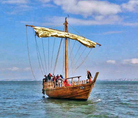
The Ma’agan Mikhael ship displayed in the Hecht Museum. Photo by Ferrell Jenkins.

Word comes that the a replica of the ship has been reconstructed and that it will be displayed for the press Friday, March 17. Here is the Press Invitation which explains about the reconstruction.

— “ —

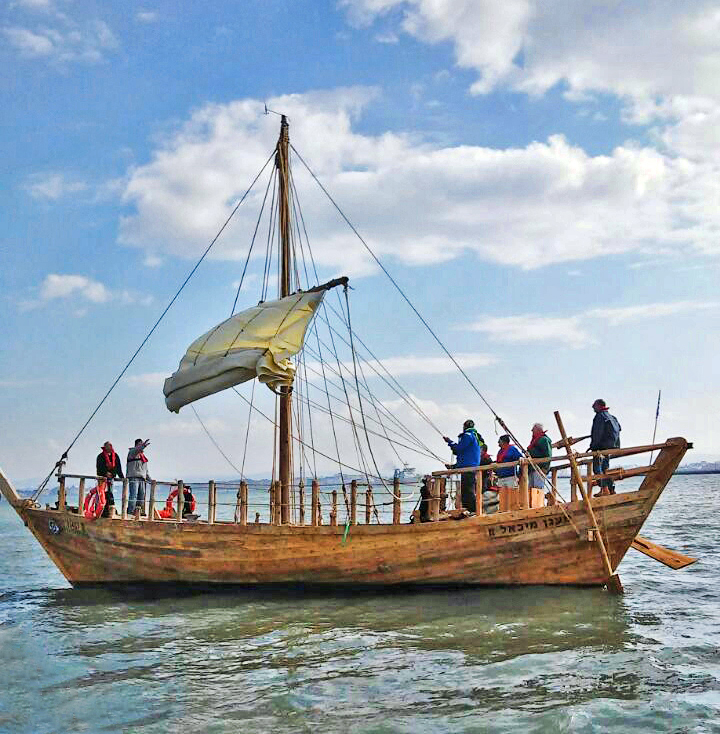
The Ma’agan Michael Ship is “going back” in the water: 2500 years after the ship sank off the coast at Ma’agan Michael, and 30 years after the shipwreck was discovered and removed from the water, a replica of the vessel will be launched. The official launching ceremony will take place this coming Friday (17 March 2017) and will be organized by the University of Haifa and the Israel Antiquities Authority. The replica was built over the past two years, using exactly the same materials, working methods, and tools that were used 2500 years ago.

The Ship launching ceremony will be attended by the President of the University, Professor Ron Robin, the Director of the Israel Antiquities Authority Mr. Yisrael Hasson, ship builders staff, volunteers and their families. According to the ancient practice of launching a new ship into the sea, oil and water to be poured into the sea for good luck (“Blessing Poseidon”), and it will set sail (weather permitting).

Ma'agan Michael-replica. Photo courtesy of the University of-Haifa.

Ma’agan Michael replica. Photo courtesy of the University of Haifa.

The ancient Ma’agan Michael Ship has always been a star. It was discovered in 1985 by Ami Eshel, a member of Kibbutz Ma’agan Michael, some 70 meters from the kibbutz. The ship was removed from the sea in 1988 in a project directed by Dr. Elisha Linder, one of the founders of the Department of Maritime Civilizations at the University of Haifa. Most of the ship had been covered in sand, helping to preserve it in a remarkable condition. The keel, numerous wooden plates, 14 crossbars, and the base of the mast were all preserved, offering researchers rare insights into the method used to construct the ship. In addition, the preserved tools found in the ship included the carpenter’s toolbox, a discovery that sparked the dream of building a replica using the same methods and tools used by the original shipwrights. In a complex procedure undertaken at the University of Haifa, a special preservative was inserted into the wooden base of the ship, which received its own display room at the university’s Hecht Museum.

The late Prof. Yaacov Kahanov of the Department of Maritime Civilizations at the University of Haifa did not abandon the dream of building a replica of the ship. Prof. Kahanov was a young research student when the ship was taken out of the water. Two years ago, he finally began the work of building a replica, together with Avner Hilman of the Israel Antiquities Authority, for whom the use of the ancient working methods formed part of a doctorate thesis. Together with a team of volunteers, they began the work, most of which took place at the Naval Academy in Akko.

However, the team working on the replica project soon encountered a problem. While they were familiar with the basic principle of the work – assembly using bolts and sockets – the other details were lost in the mists of time. They were unsure of the proper and most efficient way to bend the wooden beams in order to create the curved shape of the ship; the most suitable type of wood for the mast; and the precise temperature to which the copper nails should be heated. In many cases the team worked on a trial and error basis until they produced the desired result.

Ma'agan Michael-replica. Photo courtesy of the University of-Haifa.

Ma’agan Michael-replica. Photo courtesy of the University of-Haifa.

After two year’s work, the project was completed successfully and the replica was taken to Israel Shipyards and then to Kishon harbor. The ship will be officially launched at the harbor according to all the proper ceremonies and will return to the waters where its elder sister sailed 2500 years ago. Prof. Yaacov Kahanov, the leading spirit behind the project, passed away just before the work was completed.

The launching ceremony will take place on Friday, 17 March 2007, from 10:00 a.m. at Shavit fishing and sailing harbor in Haifa – Nachal Kishon. We invite you to cover the event.

— ” —

The Nachal (River) Kishon is where the LORD defeated Jabin and Sisera at a point several miles east of the mouth of the river (Judges 4-5; Psalm 83:9). I wish I could be there to see the ship launched.

HT: Joseph Lauer

A question about dolmen

A reader who read our report on the dolmen field in the Golan Heights ask on Facebook if these structures could be the high places or altars mentioned in the Old Testament. The simple answer is “No.” They are thought to be tombs.

This photo of a dolmen was made at Gamla in the Golan Heights.

Dolmen at Gamla in the Golan Heights. Photo by Ferrell Jenkins.

Dolmen at Gamla in the Golan Heights. Photo by Ferrell Jenkins.

In an article about the Golan Archaeological Museum at Qatzrin in the Golan Heights, Nemlich and Killebrew make these comments:

Another strange sight on the Golan is fields of dolmens. Throughout the Golan, hundreds of dolmens are visible on the horizon. They are made of huge unworked basalt slabs and resemble giant stone tables. In fact the word dolmen derives from two Old Breton words—dol, meaning table, and men, meaning stone.

Dolmens were built to serve as tombs. Because of the absence of any associated contemporary house remains, we infer that the dolmen builders were nomadic or seminomadic tribesmen.

The Golan dolmens vary in size, ranging from those built of three or four large boulders to the giants measuring over 20 feet wide and rising to heights of over 10 feet. Some dolmens are free-standing, but many others are partially—or completely—covered by stone heaps, or tumuli. Still others are surrounded by circles of stones.

Beneath each table-like structure is a rectangular underground chamber with a paved floor and a roof made with heavy slabs. Apparently, this chamber was used for a secondary burial: About a year after death, when the flesh of the deceased had decayed, the bones were reburied in the chamber beneath the dolmen, together with a few funerary gifts of pottery vessels and weapons, usually of copper. Many dolmen chambers were reused as ready-made tombs, both in ancient and modern times. The earliest artifacts found in them, however, enable us to date them to the period archaeologists call Middle Bronze I—about 2200–2000 B.C. (a little before the most commonly dated period for the patriarchal age). (Nemlich, Shlomit and Ann Killebrew. “Recovering the Ancient Golan—The Golan Archaeological Museum.” Biblical Archaeology Review.  Nov/Dec 1988.)

There are other suggestions about the purpose of the dolmen. David E. Graves left this comment, with photos, on our Facebook page:

In 2009 we excavated an undisturbed dolmen in Jordan at Tall el-Hammam and recovered 16 EB whole vessels. We did not discover any skeletal remains and so hypothesis they were family memorials and used the table top to de-flesh the remains before reburial.

Perhaps the most fascinating thing about the recently announced discovery reported this past week is the images inscribed on the dome of the dolmen. The recent IAA Press Release says this,

The chamber inside the dolmen where the engravings were found on its ceiling is large, measuring 2 × 3 meters, and the stone covering it is also huge, weighing an estimated fifty tons at least! This is one of the largest stones ever used in the construction of dolmens in the Middle East. The dolmen was enclosed within an enormous stone heap (tumulus) c. 20 meters in diameter, and its stones are estimated to weigh a minimum of 400 tons. At least four smaller dolmens that were positioned at the foot of the decorated dolmen were identified inside the stone heap. In other words, what we have here is a huge monumental structure built hierarchically (with a main cell and secondary cells). This is the first time such a hierarchical dolmen has been identified in the Middle East.

The engravings that were exposed on the inside of the built chamber. Photographic credit: Gonen Sharon, Tel Hai College.

The engravings that were exposed on the inside of the built chamber. Photographic credit: Gonen Sharon, Tel Hai College.

There is much more to learn about the dolmen.