Category Archives: Archaeology

Samson mosaics discovered at Huqoq

A Late Roman (fifth century) synagogue is being excavated at Huqoq a few miles northwest of the Sea of Galilee under the direction of Jodi Magness of the University of North Carolina and Shua Kisilevitz of the Israel Antiquities Authority.

The University of North Carolina News reports on the discovery here.

Last summer, a mosaic showing Samson and the foxes (as related in the Bible’s Judges 15:4) was discovered in the synagogue’s east aisle. This summer, another mosaic was found that shows Samson carrying the gate of Gaza on his shoulders (Judges 16:3). Adjacent to Samson are riders with horses, apparently representing Philistines.Although he is not described as such in the Hebrew Bible, Samson is depicted as a giant in both scenes, reflecting later Jewish traditions that developed about the biblical judge and hero.

Samson carrying the gate of Gaza. Discovered at Huqoq.

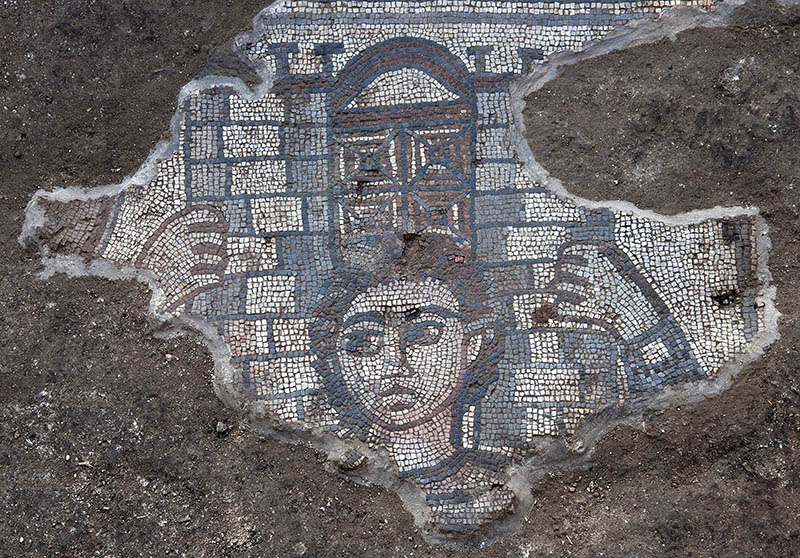
Mosaic showing Samson carrying the gate of Gaza. Discovered at Huqoq. Photo by Jim Haberman, University of North Carolina.

The book of Judges records the visit of Samson to Gaza, one of the cities of the Philistines. Samson’s conduct is not exemplary. When the Gazites laid a plan to kill him, he carries out his own plan.

 But Samson lay till midnight, and at midnight he arose and took hold of the doors of the gate of the city and the two posts, and pulled them up, bar and all, and put them on his shoulders and carried them to the top of the hill that is in front of Hebron. (Judges 16:3 ESV)

The mosaics from Huqoq illustrate that the members of the synagogue there knew the exploits of Samson.

HT: Joseph I. Lauer

Drainage channel provides evidence of Roman siege of Jerusalem

The Israel Antiquities Authority announced today that “three complete cooking pots and a small ceramic lamp were uncovered in a small cistern in a drainage channel that runs from the Shiloah [Siloam] Pool … to Robinson’s Arch.”

Cooking pots and lamp found in drainage channel near Robinson's Arch, Jerusalem. IAA Photo by Vladimir Naykhin.

Cooking pots and lamp found in a cistern in a drainage channel near Robinson’s Arch, Jerusalem. IAA Photo by Vladimir Naykhin.

According to archaeologist Eli Shukron, “This is the first time we are able to connect archaeological finds with the famine that occurred during the siege of Jerusalem at the time of the Great Revolt. The complete cooking pots and ceramic oil lamp indicate that the people went down into the cistern where they secretly ate the food that was contained in the pots, without anyone seeing them, and this is consistent with the account provided by Josephus.”

The news release sites one of the comments by Josephus in The Jewish War about “the dire hunger that prevailed in the blockaded city.” The suggestion is that some of the people cooked and ate their meals in the drainage system as they were hiding from danger.

The complete news release may be read here.

A portion of the drainage channel that runs from the southwest corner of the Temple Mount to the Pool of Siloam. Photo by Ferrell Jenkins.

A portion of the drainage channel that runs from the southwest corner of the Temple Mount to the Pool of Siloam. Photo by Ferrell Jenkins.

Read more here about the drainage channel which my group walked through May 7, 2010.

HT: Joseph I. Lauer

Roman road found in Jerusalem

A section of the Roman road that led from Joppa to Jerusalem has been found in the Beit Hanina community northeast of the Old City of Jerusalem. This road came to light during preparation for the installation of a drainage pipe.

The road is about 25 feet wide and is said to date back about 1800 years.

Roman road excavated in the Beit Hanina community. Photo: Assaf Peretz, courtesy of the Israel Antiquities Authority.

Roman road excavated in the Beit Hanina community. Photo: Assaf Peretz, courtesy of the Israel Antiquities Authority.

The IAA press release, available here, gives attention the course of the road from Joppa (Yafo) and Jerusalem.

The road section discovered in the IAA excavations in Beit Hanina is part of the imperial network of roads that led to Jerusalem from the coastal plain. We know about these roads from both historical sources and archaeological excavations. Two main arteries led from Yafo to Jerusalem during the Roman period. One is the road that passes through Bet Horon and the other runs via Shaar HaGai. This particular segment belongs to the Bet Horon road. The road began in Yafo and passed through Lod where it split it two different directions: one to Shaar HaGai and the other by way of Modiin along the route of what is today Highway 443 to Bet Horon. From there the road continued eastward as far as Bir Nabala and turned south to Kefar Shmuel where it merged with the highlands road that led to the Old City of Jerusalem.

The Times of Israel includes a map here showing the location of the uncovered section of road.

HT: Joseph Lauer

In search of Dalmanutha

After the feeding of the four thousand, Jesus went to the district of Dalmanutha.

And immediately he got into the boat with his disciples and went to the district of Dalmanutha. (Mark 8:10 ESV)

This is the only Biblical reference to a place called Dalmanutha. Where was it? When we read the parallel account in Matthew 15:32-39, we learn that Jesus came to the region of Magadan.

And after sending away the crowds, he got into the boat and went to the region of Magadan.  (Matthew 15:39 ESV)

Todd Bolen, at Bible Places Blog, notes that some scholars equate Dalmanutha with Magadan/Magdala. He says,

Mendel Nun has proposed that Dalmanutha be identified with a small anchorage north of Magdala (Anchor Bible Dictionary 2:4). Dalmanutha may not be a proper name but simply the Aramaic word for harbor.

In an article on “Ancient Harbors Of The Sea Of Galilee,” Gordon Franz discusses the location of Magdala/Dalmanutha. Perhaps Dalmanutha “is a transliteration of the Syrian word for harbor.” Or, the term may derive from the harbor that existed here. Franz describes the harbor:

It consisted of two parts; an open dock for loading and unloading during the summer, and a basin, with a 70 m breakwater to protect the ships from the winter storms. (Bible and Spade (1991) Volume 4, 04. p. 120.)

This new discussion about Dalmanutha has been prompted by a recent lecture by Dr. Ken Dark at the Centre for the Study of Christian Origins in the School of Divinity, University of Edinburgh. Helen Bond reports here that Dark spoke of mapping the area around Nazareth and the Sea of Galilee. Notice the summary of Dark’s comments on Dalmanutha:

A new research project is synthesising existing data and using air- and satellite-photography to re-examine the area, combined with the first extensive archaeological survey of the Ginosar valley. The latter has identified a very large, but previously-unrecognised, Late Hellenistic, Roman-period, and later, settlement between the modern town of Migdal (on the western side of the valley) and the coast, just south of Kibbutz Ginosar.  It is hard to imagine that a Roman-period coastal community of this size is nowhere mentioned in textual sources, and the site might be identified with one of the unlocated toponyms known from the Bible, perhaps the Dalmanutha of Mark 8:10.

The aerial photo below shows the general area under consideration. Magdala is on the left of the photo. On the right you can see the museum at Nof Ginosaur where the Roman Boat is shown. Part of the building is hidden behind the wing strut of the airplane.

Aerial view of the Plain of Genessaret from Magdala on the south (left) to Nof Ginosaur on the north (right). Photo by Ferrell Jenkins.

Aerial view of the Plain of Genessaret from Magdala on the south (left) to Nof Ginosaur on the north (right). Photo by Ferrell Jenkins.

The green strip between the water and the land is covered by water this year. You see two places where the growth has been cleared away to make room for a beach.

So, we have several options for the location or meaning of Dalmanutha. In a post to follow I will show you the traditional site of Dalmanutha.

HT: Bible Places Blog; Larry Hurtado’s Blog

Facebook site for Tell el-Amarna

Some archaeological projects have Facebook pages. Check out this one on the Egyptian site of Tell el-Amarna here.

Amarna Letter from the Egyptian ruler of Jerusalem to Amenophis III. Pergamum Museum, Berlin. Photo by Ferrell Jenkins.

Amarna Letter from the Egyptian ruler of Jerusalem to Amenophis III. Pergamum Museum, Berlin. Photo by Ferrell Jenkins.

This letter dates to the reign of Amenophis III (1391-1353 B.C.).

Calf and sanctuary found at Ashkelon

Professor Lawrence E. Stager of Harvard writes about the discovery of the silver calf at Ashkelon in the summer of 1990.

In the waning days of the season, on the outskirts of the Canaanite city, we excavated an exquisitely crafted statuette of a silver calf, a religious icon associated with the worship of El or Baal in Canaan and, later, with the Israelite God, Yahweh. The calf lay buried in the debris on the ancient rampart that had protected the city in the Middle Bronze Age (c. 2000–1550 B.C.). (BAR 17:02 (March/April 1991), ed. Hershel Shanks (Biblical Archaeology Society, 1991).

In Life in Biblical Israel, by King and Stager, the calf is dated “around 1600 B.C.E. (p. 173). This bull calf and the pottery shrine in which it was found is now in the Israel Museum in Jerusalem.

Silver calf and sanctuary found at Ashkelon. Photo by Ferrell Jenkins.

Bronze and silver calf and sanctuary found at Ashkelon. Photo by Ferrell Jenkins.

Bible students recall the golden calf made by Aaron at Mount Sinai (Exodus 32:4).

They made a calf in Horeb and worshiped a metal image. (Psalm 106:19 ESV)

We also know about the golden calves erected by Jeroboam I at Dan and Bethel (1 Kings 12:28-30). In the prophet Hosea we find references to calves in Samaria (8:5-6) and Beth-aven (10:5).

Stager calls attention to a significant reference in Hosea 13:1.

When Ephraim spoke, there was trembling; he was exalted in Israel, but he incurred guilt through Baal and died. And now they sin more and more, and make for themselves metal images, idols skillfully made of their silver, all of them the work of craftsmen. It is said of them, “Those who offer human sacrifice kiss calves!”  (Hosea 13:1-2 ESV)

The discoveries of archaeology often shed light on biblical accounts and help us to see the reality of them.

For a photo of a bull from the Samaria region, see here.

Ashkelon excavation underway

‘Tis the season for archaeological digs. At Ashkelon, the Leon Levy Expedition runs from June 8 – July 19 this year. It is sponsored by Harvard’s Semitic Museum, Boston College, Wheaton College, and Troy University.

I have two young friends, Trent and Rebekah, who are working in the dig. They will not be writing up any marvelous new discoveries that might be made. This is always reserved for the directors of a dig to announce, and then later to publish. My friends are sharing some general information about their participation in the dig as time permits. They are there as part of Dr. Daniel Master’s team from Wheaton College.

Trent has allowed me to use one of his photos of Grid 51. This is the Grid he has been working in during the past week. He informs me that this is about 1/4 mile southwest of the Canaanite Gate, and belongs to the Persian period. At the time Ashkelon was an important port aligned with Tyre and occupied by Phoenicians.

Grid 51 of the current Ashkelon excavation. Photo by Trent Dutton.

Grid 51 of the current Ashkelon excavation. Photo by Trent Dutton.

Notice that the Mediterranean Sea is visible to the west. The photo below shows the view south toward Gaza and Egypt and may include Grid 51.

View south along the beach at Ashkelon. Photo by Ferrell Jenkins.

View south along the beach at Ashkelon. Photo by Ferrell Jenkins.

According to 1 Samuel 6:17 there were five important Philistine cities: Ashdod, Gaza, Ashkelon, Gath, and Ekron. Ashkelon had a long history including occupation by Canaanites, Egyptians, Philistines, Phoenicians, Greeks, Romans, Byzantines, Muslims, Crusaders, and finally by Mamelukes.

If you would like to follow what Trent and Rebekah are able to share, see their blog here.

A synagogue on the island of Delos

In the previous post we mentioned that there were numerous synagogues used by Jews of the Diaspora. Paul visited synagogues in many of the cities where he preached.

During his Spring travels, Dr. Carl Rasmussen visited the Greek island of Delos. Delos is one of those places that can only be reached with much effort. Carl has graciously granted permission for me to use a couple of his photos here. The first one shows a view to the west, southwest, showing various rooms of the synagogue. Note the “Moses Seat” in the upper right of the photo. The entrance is visible in the lower left.

Delos synagogue. Photo by HolyLandPhotos.

Delos synagogue. Photo by Carl Rasmussen, HolyLandPhotos.

The second photo shows a close up of the “Moses Seat” and the marble seats on each side. You may click on the photos for larger images provided by Dr. Rasmussen at the HolyLandPhotos’ Blog.

Delos synagogue. Photo by Carl Rasmussen, HolyLandPhotos.

Delos synagogue. Photo by Carl Rasmussen, HolyLandPhotos.

This large synagogue dates to the mid-second century B.C. Two inscriptions found in 1979-80 indicate that the worshipers here (Israelites) were likely Samaritans who revered Argarizein (Mount Gerizim). (See Kraabel, “New Evidence of the Samaritan Diaspora has been Found on Delos.” BA 47:1; 1984).

The Moses Seat. We commonly identify a special seat like the one in this synagogue as the Seat of Moses. Jesus may have made reference to such a seat (Matthew 23:2-3). For more information about the “Moses Seat” see here. Michael White suggests at least the possibility that this seat may be a “Proedrion, either for the major donor (or patron) or for the leader of the group” (HTR 80:2 (1987). I don’t see that this changes the fact that a reader and teacher of the Law might sit here.

If you have any interest in the synagogues scattered over the Mediterranean world, you will want to visit the HolyLandPhotos’ Blog here.

Tradition has it that Delos is the birthplace of Apollo, the son of Zeus, and his twin sister Artemis.

Marble head of Apolls from Perga. Second century A.D. Photo by Ferrell Jenkins.

Marble head of Apolls from Perga. Second century A.D. Photo by Ferrell Jenkins in the Antalya Archaeological Museum.

An article by Gordon Franz a few years ago piqued my interest in Delos. He wrote on “The Synagogue On The Island Of Delos And The Epistle Of James” in Bible and Spade (18:3; 2005). Franz provides the history and geography of the island. He includes a photo of the “Samaritan inscription,” and then proceeds to use the synagogue of Delos to illustrate two passages from the Epistle of James. He discusses James 2:2-4 and selected verses from James 3.

For those who have an interest in visiting Delos, Prof. Rasmussen explains exactly how to reach the synagogue from the Delos Museum. Rasmussen is author of the Zondervan Atlas of the Bible, and provides nearly 4000 thousand photos at the Holy Land Photos archive.

The synagogue — a place of study and discussion

The origin of the synagogue is difficult to determine, but it is generally held that it arose during the time of the Babylonian exile. Synagogues did not become common until the intertestamental period. The term intertestamental is used by many writers to describe the period between the close of the Old Testament (about 425 B.C.) and the coming of John the Baptist in the early first century A.D. Others use the term interbiblical, or the longer phrase, between the testaments.

With the destruction of the Temple (586 B.C.), sacrifices ceased. Prayer and the study of the sacred Scriptures, however knew no geographical limitations. The Book of Ezekiel describes the elders of Israel gathering in the prophet’s house (8:1; 20:1-3) (Charles Pfeiffer, Between the Testaments, 59).

In the sixth year, in the sixth month, on the fifth day of the month, as I sat in my house, with the elders of Judah sitting before me, the hand of the Lord GOD fell upon me there. (Ezekiel 8:1 ESV)

In the seventh year, in the fifth month, on the tenth day of the month, certain of the elders of Israel came to inquire of the LORD, and sat before me. And the word of the LORD came to me: “Son of man, speak to the elders of Israel, and say to them, Thus says the Lord GOD, Is it to inquire of me that you come? As I live, declares the Lord GOD, I will not be inquired of by you. (Ezekiel 20:1-3 ESV)

The word synagogue is of Greek origin. It simply refers to a gathering of the people, or a congregation. “The Hebrew word for such a gathering is keneseth, the name used for the parliament in the modern state of Israel” (Pfeiffer, 59).
After the rebuilding of the Temple (520–516 B.C.), the synagogue continued to fill the spiritual needs of the Jews of the Diaspora. There were synagogues in many of the cities visited by Paul: Damascus (Acts 9:2); Salamis (13:5); Antioch of Pisidia (13:14); Thessalonica (17:1); Corinth (18:4); Ephesus (19:8), and others. Only ten families were needed to compose a synagogue.

In 1898 a partial inscription mentioning a “synagogue of the Hebrews” was found at Corinth. It was published by Benjamin Powell in 1903 and identified as having come from the synagogue where Paul preached. McRay says that further study showed that it should be dated considerably later than the time of Paul. (Archaeology and the New Testament, p. 319).

Synagogue Inscription displayed in Corinth Museum. Photo by Ferrell Jenkins.

Synagogue Inscription displayed in Corinth Museum. Photo by Ferrell Jenkins.

A small plaque mounted underneath the inscription at the Corinth Museum reads, “Inscription from a late Roman synagogue.”

One rabbinic tradition has it that there were 480 synagogues in Jerusalem alone. Even the small villages of Galilee had synagogues at the time of Jesus (Mt. 4:23; 9:35).

Excavation of the Ophel continues

April 27 I was looking at the Ophel Excavations that are under the direction of Dr. Eilat Mazar. When I saw the tarp, I decided I would make a photo in hopes of learning something new in the future. The future is now.

According to The Key to David’s City, a web site devoted to the work of Herbert W. Armstrong College in Jerusalem, Dr. Mazar officially reopened the excavations on April 22.

In this continuation of the second phase Dr. Mazar will continue uncovering what she believes is a royal complex belonging to King Solomon, dated to the 10th century B.C.E., located at the foot of the Temple Mount in Jerusalem. As she works to expose more of this massive structure, the excavation will continue “to follow the remains of the First Temple Period along the line of the City Wall,” she told us.

The Key to David’s City web site has posted several nice videos explaining some aspects of the archaeological work at the site. The Gallery includes some excellent photos.

My photo below shows the area of the new excavation.

New Ophel excavations. Photo by Ferrell Jenkins.

Area of new Ophel excavations. Photo by Ferrell Jenkins.

We called attention to the Ophel Excavations 2012 here.

Jothan, king of Judah (740-732 B.C.), is said to have built extensively in the area known as Ophel.

He built the Upper Gate to the LORD’s temple and did a lot of work on the wall in the area known as Ophel. (2 Chronicles 27:3 NET)