
The title could be misleading. It could be like all of those drawings showing John the Baptist pouring water over the head of Jesus. The Adam we speak of is a place mentioned in the account of the Israelite crossing of the Jordan River.
the waters which were flowing down from above stood and rose up in one heap, a great distance away at Adam, the city that is beside Zarethan; and those which were flowing down toward the sea of the Arabah, the Salt Sea, were completely cut off. So the people crossed opposite Jericho. (Joshua 3:16)
Our fellow-blogger over at Aantekeningen bij de Bijbel in the Netherlands asks,
Do you have also pictures from the Jordan in the neighbourhood of Adam? The place where the Jordan was halted for some time?
To my knowledge It is not possible to approach the Jordan except an area between the Sea of Galilee and Beth-shan, and at Bethany Beyond the Jordan. Photos are not allowed at the various military check points.
The best I can do is to show you a photo I made in November of 2005. This photo is looking east toward the mountains of Gilead. I think the rift to the right of the middle of the photo is the Jabbok Valley. Adam would be located somewhere to the right in this photo. If some other reader can be more specific I would be happy to know.
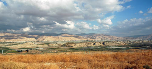
The fence in the foreground of the photo is the boundary between Israel (West Bank area) and Jordan. I often describe the Jordan River as being shy. All along the Jordan Rift, one only sees the River at a place or two. The Jordan flows in the green area in the bottom of the rift. All of the white horizontal lines in the photo are hot houses use for growing agricultural produce.

You must be logged in to post a comment.