Category Archives: Travel

Corinth and Neighboring Cities

After Jerusalem, Corinth is one of the best-known cities mentioned in the New Testament. The apostle Paul visited Corinth on his second preaching tour (Acts 18). At the “judgment seat” (Greek, bema) in the agora Paul stood before the proconsul Gallio. Based on the inscription now exhibited in the museum at Delphi we think that Paul entered Corinth in the fall of A.D. 51, and left in the spring of A.D. 53.

The map is cropped from a larger map of the area around Corinth on the Bible Mapper Blog here.

Since my last visit to Corinth some reconstruction has been made on the Bema and our photo below is published courtesy of Charles Savelle of BibleX.

The Bema at Corinth with the Acrocorinth in the background.
The Bema where Paul stood before proconsul Gallio. The Acrocorinth looms over the city. Photo courtesy of Charles Savelle.

Corinth is located about two miles south of the narrow isthmus which forms the land bridge, and controlled access, between the main land mass of Greece and the Peloponnese. The isthmus is less than five miles wide. Small ships were dragged across the isthmus on the paved road now called the diolkos; larger ships unloaded their cargo which was carried across and reloaded. This avoided the long 200-mile journey around the Peloponnese. Nero abandoned his attempts to dig a canal across the isthmus (A. D. 67). Some scholars think the road only allowed the “occasional movement of military ships, conveyance of building materials from the southern to northern Corinthia, small-scale portaging of luxury goods, and [served as] the principal road from the Corinthian Gulf to the pan-Hellenic sanctuary of Poseidon at Isthmia” (Pettegrew, CorinthianMatters.com blog). The canal one sees today was constructed in 1881–1893.

Corinth “was situated on a plateau overlooking the Isthmus of Corinth about two miles from the Gulf. It lay at the foot of Acrocorinth, an acropolis which rises precipitously to 1,886 ft.…” and was easily defended in ancient times (Rupprecht 960).

Corinth had two good ports. Lechaion, to the west, on the Gulf of Corinth (an arm of the Ionian Sea), and Cenchrea, to the east, on the Saronic Gulf (an arm of the Aegean Sea).

The harbor of Cenchrea, home of Phoebe. From here Paul set sail for Judea.
The harbor of Cenchrea where Paul had his hair cut before departing for Jerusalem. Cenchrea was the home of Phoebe (Romans 16:1).

Another important community near Corinth was Isthmia. The biennial Isthmian games, second in importance to the Olympic games, were held there in honor of Poseidon at the isthmus of Corinth. Some scholars think Paul may have been present for one of these events while he was at Corinth. He frequently used athletic illustrations in his letters. See 1 Corinthians 9:24-25 as an example.

The location of the ancient Isthmian games of Greece.
Ruins of the ancient site of Isthmia. The Corinth canal is to the right of this image. View is to the North West.

Over the years since the beginning of this blog I have posted several articles about Corinth. I suggest you put the name Corinth in the Search Box for a list of these posts. I think of this blog as a mini-dictionary of Bible lands and customs. I hope you will find it useful in your study of the Bible. Share it with you friends and suggest that they join our mailing list.

Hierapolis – the Sacred Pool

Hierapolis is mentioned only once in the New Testament. The apostle Paul mentions Epaphras as a brother who has worked hard for the saints of the Lycus River valley.

For I bear him witness that he has worked hard for you and for those in Laodicea and in Hierapolis. (Col. 4:13 ESV)

Hierapolis is noted for its warm springs which attract visitors due to their beauty and healing benefits.

The places where one may walk on the limestone cascades, or wade, or swim in the warm water is limited. But there is one public pool. Most of the time it is crowded with tourists, but I caught a time when very few were in it.

Fant and Reddish explain the significance of the pool.

The pool has attracted visitors throughout its history. During the Roman period, columned porticoes surrounded the pool. As a result of earthquake damage, several of the columns and other architectural pieces tumbled into the pool, where they can still be seen today. (A Guide to Biblical Sites in Greece and Turkey, p. 212).

One of the springs at Hierapolis now flows over the ruins of an ancient temple.

Visitors generally disregard the signs which ask them to stay off the newly formed hillsides.

In modern times the warm water is channeled to turn the hillsides into cotton castles. The town is now known as Pamukkale, a word meaning cotton castle or cotton fortress.

Looking south you may be able to see some of the ruins of Laodicea about six miles away. Colossae is located about ten miles southeast (to the left of this image).

Tirzah, Israel’s second capital

Tirzah is used in the Bible as the name of one of the daughters of Zelopehad. She and her sisters were married into the clans of the people of Manasseh the son of Joseph (Numbers 36:11; Joshua 12:24). The man in Song of Songs (or Solomon) tells his lady “You are beautiful as Tirzah, my love, lovely as Jerusalem, awesome as an army with banners” (6:4 ESV). The context, including Jerusalem, indicates he is comparing her to a beautiful city.

Tel el Farah north in March, 2022. A few stones from the excavations are visible among the weeds. Photo by Ferrell Jenkins.
This photo shows a few of the excavated ruins of Tel el Farah, thought to be the site of Tirzah.

In today’s post we consider the name Tirzah as the name of a place.

  • Joshua captured the king of Tirzah during the conquest of the promised land (Joshua 12:24; 17:3).
  • Earlier when Abraham was at Shechem, the LORD promised him and his descendants the land of Canaan (modern Nablus) (Genesis 12:1-9).
  • About 931 BC after the death of Solomon Jeroboam rebelled and became king over Israel (the northern kingdom) at Shechem (1 Kings 11). Later the capital was moved to Tirzah (1 Kings 14:17).
  • R. K. Harrison describes the importance of Tirzah in the kingdom of Israel: “perhaps as the result of increasing political and economic relationships with Syria. Tirzah was the capital of Israel during the time of Baasha (1 Kings 15:21,33) and Elah (1 Kings 16:8-9). The seven-day reign of Zimri ended when he burned the palace over himself at Tirzah was being besieged by Omri (1 Kings 16:17-18). After ruling from Tirzah for six years, Omri moved the capital of Israel to Samaria (1 Kings 16:23-24) , probably because of his economic and political alignment with Phoenicia. Menahem, a resident of Tirzah, was able to overthrow Shallum (752 B.C.) toward the close of the northern kingdom’s existence and to usurp the throne, ruling for almost eleven years.
Caretaker at Tel el Farah (Tirzah) in 1982. Photo by Ferrell Jenkins.
In 1982 I first visited Tel el Farah with the late Jimmy Cravens, a photographer friend from Tampa, Florida. The site still showed evidence of excavation. The gentlemen in the photo lived in a little house on the tel and served as the caretaker. I recall that he is showing us some of the walls that indicated a divider between the poor and those better off. He said he had worked with De Vaux during all of the excavations. The image is scanned from a slide that is still in good condition after 40 years.

The location of Tirzah is not certain. W. F. Albright identified it with Tel el Farah, a mound located about seven miles NE of Shechem (at modern Nablus). Roland De Vaux was associated with the Ecole Biblique in Jerusalem and conducted nine seasons of archaeological excavations at Tel el Farah between 1946 and 1960. Most of the tel is currently covered by an orchard.

Shrine model from Tel el Farah north from the excavations. Now in the Louvre.
Several archaeological artifacts from Tel el Farah are displayed in the Louvre. This is a shrine or temple model from the site.

Tel el Farah north (likely Tirzah) should not be confused with Tel el-Farah south (likely Besor). See our article about a visit there a few years ago here. Google Earth Pro includes one photo from the south site with the information about the north site. It is easy to make this mistake.

If you wish to look up the site on Google Earth Pro or the maps you will need to search for Tel Fara North. Remember also that the site is in Palestine.

Streams in the Negev (Negeb; South)

Nelson Glueck (pronounced Glick), wrote Rivers in the Desert, a History of the Negev, in 1959. This book is still fascinating to read. You may find a few words in the following quotation that are rarely heard in our daily conversations. A wadi is a dry river (Nahal) or creek bed that is filled with water during the rain seasons in Israel.

Read Glueck’s description of the…

Terraces built across wadi beds to brake and exact tribute from the occasional winter and spring freshets, cisterns and reservoirs dug and plastered watertight to be filled from their meed [a now-archaic word meaning deserved share or reward] against the certainty of many a rainless day, and all the other devices perfected or invented by the Nabataeans and utilized and even expanded in instances by their immediate successors, could never accomplish for the countryside at large the miracles of rebirth that: a single rainfall over a wide area was able to perform. The grass and flowers fairly spring up after the first shower or storm, and the grim desert becomes a colorful garden overnight. It is as if a magic wand had been passed over the face of the earth. Flocks of birds suddenly make their appearance then, to sing and to swoop about in happy flight, and bands of gazelles and ibexes graze and cavort through the lush green. Camels and goats and sheep and their young wax fat. They drink their fill at pools of water collected in hollows, making it unnecessary for months on end to find other supplies for them. Springs flow more strongly, wells rise to their highest levels and the underground water is replenished in the wadi beds, there to remain long after the flowers have faded and the grass has withered and gone. Sturdy shrubs remain green all summer long because their roots tap the subsurface moisture. This is particularly true where the wadis are wide and shallow and terraced, with the result that the rain waters tend to sink into the ground. Otherwise, if unhindered, they race down narrow gullies and dry stream beds, stripping off the covering soil and gouging out for themselves ever deeper canyons. (Nelson Glueck. Rivers in the Desert: A History of the Negev.  Rivers in the Desert: A History of the Negev. New York: Norton, 1968; 92-93.)

I can’t begin to show you photos of every element mentioned by Glueck in this paragraph, but I will show you a couple of photos from the Wadi Zin in the Negev. First, here is a map from the from the wonderful collection on David P. Barrett’s Bible Mapper Blog.

Our first photo is a view of Wadi Zin a few miles south of Avdat in the Negev of Israel.

Wadi Zin in the Negev of Israel.

You will see evidence here of water having been at high levels. Various shrubs grow where the water remains the longest.

The next photo shows how the swift water cuts it way through the rocks.

The Wadi Zin.

The Stadium in New Testament Times

Aphrodisias, located in southwest Turkey, was an ancient city of Caria in Asia Minor. It is not mentioned in the Bible, but is close to the cities of Laodicea, Hierapolis and Colossae. Robert F. Tannenbaum, an ancient historian, describes the location of the city this way:

A quiet, fertile valley folded into the Mediterranean hills, clear streams, tall poplars, ancient ruins more than 1,400 years old—a picture of pastoral quiet. (Biblical Archaeology Review, Sept/Oct 1986)

BibleMapper_Aphrodisiash

The map above is cropped from the set of BibleMapper maps now available at
https://biblemapper.com/blog//. Aphrodisias is clearly marked.

The site has been excavated since 1966, beginning under the direction of Kenan Erim of New York University. Marble was readily available at a nearby quarry and the excavation has brought to light a multitude of marble inscriptions and statues from the Roman period including a statue of the Emperor Domitian. Buildings include a theater, an agora, a bath, temples, and a well-preserved stadium.

Louw-Nida describes a stadium as an “open, oval area (frequently including a racetrack) around which was built an enclosed series of tiers of seats for those who came to watch the spectacles – arena, stadium.” When Paul spoke of running the race in 1 Corinthians 9:24, he used the Greek term stadion. The term was also used as a measure of distance and is found in John 6:19. It was about one-eighth of a Roman mile. Most large Greek and Roman cities had a stadium. The figure of the stadium is in mind in Hebrews 12:1-2, where a host of witnesses watch as we run the race.

Therefore, since we are surrounded by so great a cloud of witnesses, let us also lay aside every weight, and sin which clings so closely, and let us run with endurance the race that is set before us,
2 looking to Jesus, the founder and perfecter of our faith, who for the joy that was set before him endured the cross, despising the shame, and is seated at the right hand of the throne of God.
(Hebrews 12:1-2 ESV)

The stadium at Aphrodisias is the best preserved I have seen and I wanted to share with you the photo I made in 2012. Picture yourself in the stadium.

Aphrodisias

Thank you

Paulette and I appreciate every comment and “like” that has been left on either https://ferrelljenkins.blog or Facebook. We had a lot of fun with our friends at church in the weeks leading up to the marriage. So many wanted to know when we were getting married, who would be present, where we would go for the honeymoon, etc. We kept everyone in suspense and pulled it off without anyone decorating our vehicle or crashing the wedding.

We stayed at home the first night, then spent a few days in the Sarasota, FL, area. No need to go far when one already lives in a tourist paradise. We enjoyed visiting the mall, eating at some famous restaurants like Yoder’s Amish Restaurant and the Columbia at Saint Armands Circle. At the latter we enjoyed the famous Cuban sandwich with Spanish Bean soup followed by an order of flan.

Topping off a great meal with the Columbia’s famous flan.

We had a little setback last week when we both tested positive for the Covid virus. We both have been fully vaccinated and I have survived trips to both Turkey and Israel without any problem. We have tried to trace our activities and determine where we might have picked up the Covid. We think it was either at church or at one of our favorite eating places but there is no way to be certain.

Even though I think of this as a lite case of the virus it is a jolt to the body. Along with isolation we have been taking Paxlovid medication. I have one more dose today and Paulette has one more day to go. We are seeing improvements each day.

Don’t throw away your masks too soon.

The Death of Archaeologist Eilat Mazar

This afternoon I received an Email from Tali Aronsky, International Media Director, The Hebrew University of Jerusalem, about the death of Dr. Eilat Mazar. His brief report reads as follows:

(Jerusalem, May 25, 2021)—Dr. Eilat Mazar, a pioneering archaeology professor at the Hebrew University of Jerusalem’s Institute of Archaeology died today, she was 64.  Mazar was a third-generation Israeli archaeologist who participated in digs from a young age, as the granddaughter of Benjamin Mazar who excavated the Land of Israel during the British Mandate period.  Eilat Mazar specialized in the Phoenician culture of Israel’s northern coastal plain and directed excavations in the City of David and the Temple Mount’s southern wall. 

During her tenure, Mazar discovered the possible remnants of King David’s palace and a portion of an ancient city wall presumed to be built by King Solomon.   In 2013, Mazar unearthed a trove of gold coins and a rare Byzantine medallion with a menorah (candelabra) etched into it.  Most recently, Mazar made headlines when she unearthed clay seals “Belonging to Hezekiah, (son of) Ahaz, King of Judah” and later, seals that may have belonged to Isaiah the Prophet. 

Mazar is survived by a daughter and three sons.


Dr. Mazar’s name will be found several times on this blog. I appreciated the opportunity to meet her in 2019 when Luke Chandler and I were visiting with Dr. Yosef Garfinkle in the archaeology lab at Hebrew University. She was very pleasant and graciously posed for a photo with us.

From left to right, Luke Chandler, Dr. Yosef Garfinkle, Dr. Eilat Mazar, and Ferrell Jenkins in the archaeology lab at the Hebrew University of Jerusalem.

St. Patrick’s Day. A Family and Religious Connection to Ireland

It has been my pleasure to lead a few tours to Ireland. I always felt a connection to the country because one fourth of my family history (maternal grandmother) is easily traced back to Ireland. And I sense a slight connection through the religious leaders Thomas and Alexander Campbell.

Thomas Campbell was born in County Down, Ireland, February 1, 1763, but he was educated at the University of Glasgow, Scotland. He became a Presbyterian minister but gradually came to question allegiance to the Westminster Confession of Faith. Whether he said it in these exact words his writings agree with the phrase, “Where the Scriptures speak, we speak; where the Scriptures are silent, we are silent.” As a result of bad health Thomas came to American in 1807 ahead of the planned trip for his family. He settled and eventually died in Bethany, [West] Virginia in 1854.

At one point in his life Thomas Campbell settled at Rich Hill in [northern] Ireland and preached for a nearby Presbyterian church. In order to make ends meet he began an academy with the help of his son Alexander. Eva Jean Wrather, Alexander Campbell : adventurer in freedom : a literary biography, says,

Thomas decided to take up his old occupation of schoolmaster. This time, he would open his own academy. The prospect was especially inviting since Alexander, now age sixteen, was proficient enough in the ordinary branches of learning to act as his assistant.

Campbell lived in this multi-story house with fourteen windows on the square of Rich Hill that provided enough space for the family and the school.

Campbell Country Photos - House in Rich Hill, Ireland, where the

This house faced a much larger house on the opposite side of the square that was occupied by the family of William Richardson the Lord of Rich Hill Castle and high sheriff. Eventually Alexander was hired to serve as tutor to the Richardson daughters. The house now seems to be unoccupied and in need of repair.

Campbell Country Photos - Richardson Castle in Rich Hill, Irelan

Alexander was born in County Antrim, Ireland, about a mile from Shane’s Castle, September 12, 1788. He died at Bethany, West Virginia in 1866.

Thomas sent word for the family to join him in America. They sailed on the Hibernia through Lough Foyle from Londonderry, passing McGilligan’s Point, October 1, 1808. The ship encountered a storm and was shipwrecked on the island of Islay. From there they went into Glasgow, Scotland, and lived for nearly a year. Alexander used the opportunity to attend the University of Glasgow, Scotland. He was greatly influenced by James and Robert Haldane, of the Church of Scotland. They set up independent churches with elders over each church, and observed the Lord’s Supper each Sunday. Alexander soon cut his ties with the Presbyterians.

The Campbell family sailed from Scotland on August 3, 1809 and came to America after 57days of sailing. Alexander and Thomas had independently come to similar religious views. The Campbells organized the Brush Run church, near Washington, Pennsylvania., in 1811. After a year-long study Alexander Campbell was convinced that baptism was immersion. In 1812 he had a Baptist preacher to immerse him in Buffalo Creek. Soon other members of the family and of the Brush Run church were immersed.

Along with other leaders such as Barton W. Stone, Thomas and Alexander became leaders in a movement commonly called the Stone-Campbell Movement.

Some additional information about the Campbell stay in Rich Hill and their efforts to teach the Gospel is available at the Restoration Movement website here.


N.B. I have not forgotten the promised series on the Seven Churches of Revelation. Health concerns in my family have prevented me from completing these post.

Inauguration on the Nile, 2021

This is a re-post from USA Inauguration Day in 2009 and 2013.

Shortly before sunset, January 20, 2009, I made a few photos of the Nile River looking toward the west bank of the river. I thought I would share this one with you.

Sunset on the Nile during Inaguration. Photo: ferrelljenkins.blog.

Sunset during a Nile River cruise January 20, 2009. Photo by Ferrell Jenkins.

We are anchored on the Nile a few miles south of Luxor. From my cabin on the Tu Ya cruise boat I am watching the Al Jazeera Network live coverage of the inauguration ceremonies in Washington. The choice of the majority of voters on November 2 was not my choice, but I must say that I am proud at this moment to be an American.

The American ideal of freedom and justice for all is a noble one. Surely there are times when this ideal is not met, but it remains the dream that holds us together, many as one. The diversity of our nation is a testimony to the vitality of that dream.

The inaugural ceremony is the same whether watching it live in Washington, on Al Jezeera in Egypt, or on CBS, NBC, CNN, Fox, or one of the other networks in the United States. Well, maybe. The thing that makes the difference is the commentary afterwards and the news chosen to run underneath the live event.

Added Note: I wish to call attention to a fine article by David Diestelkamp in the recent issue of Think under the title @notmyCaesar.

Problems faced by the Seven Churches # 4

The city of Thyatira, modern Akhisar, Turkey, is said to be the least important city among the seven mentioned in the book of Revelation. Yamauchi quotes Pliny the Elder’s statement about Thyatira in the Roman period as “a city of no first-rate dignity” (The Archaeology of New Testament Cities, 51). Thyatira was strategically situated on a main road that ran between Pergamum and Laodicea. Philadelphia also was on this road. Most travel was through the valleys. This road, which was part of “the imperial post road linking Italy-Greece-Asia Minor with Egypt, gave it commercial importance” (New International Dictionary of Church History, 974). The modern road between Izmir and Thyatira is good, but the road between Pergamum and Thyatira has not been among the best during my trips. See map here.

Inscriptions and coins show that Thyatira was noted for its many trade-guilds, roughly equivalent to our labor unions. “There are references to unions of clothiers, bakers, tanners, potters, linen-workers, wool-merchants, slave-traders, copper-smiths and dyers” (Hemer, “Unto the Angels of the Churches,” Bible History 11 (1975). 110). The Christians who lived there objected to the guilds because of the guild rites which required all members to eat a sacrificial meal and to honor a pagan deity. Immorality was often associated with the banquets.

One of the most prominent deities at Thyatira was Tyrimnos, an ancient sun god, but there was also a Artemis type temple whose goddess was called Boreitene. No temple to the Roman Emperor was ever built there. Cosmades says, “When the Romans took over the city, the emperor-worship cult was united with the dominant system” (Nothing Beside Remains, p. 56). Even without a temple to the Emperor at least four Christians of Thyatira (mid third century) were taken to Pergamum and martyred (Meinardus, St. John of Patmos and the Seven Churches of the Apocalypse, p. 95).

The major excavated ruins of Thyatira cover a square block in the center of modern Akhisar, Turkey.

Thyatira rooftop view. Photo: ferrelljenkins.blog.

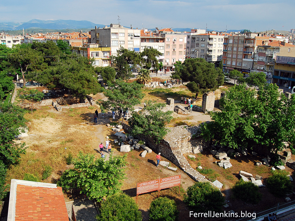
A rooftop view of Thyatira. Photo by Ferrell Jenkins.

For years columns and arches of the ancient city have lain scattered across the square block in Akhisar. In October, 2020, Dr. Mark Wilson, author of Biblical Turkey who makes Turkey his home, was able to get his first photo of the restored stoa of Thyatira. I have only seen it in the ruins.

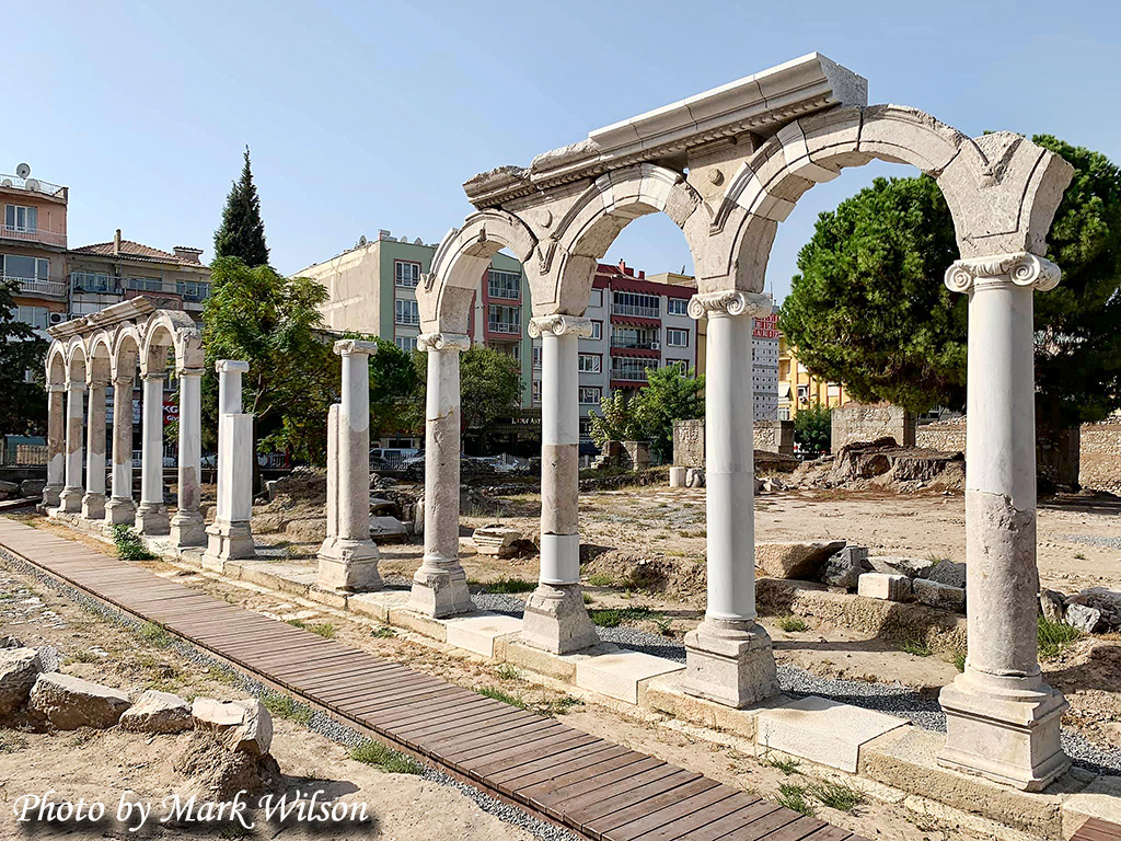
The recently reconstructed stoa of Thyatira. Photo by Dr. Mark Wilson. Used by permission.

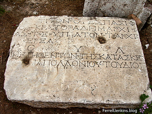
There are numerous inscriptions strewn among the ruins of Thyatira that illustrate some aspects of this longest of the seven letters [edicts].

You may have noted that various statements about the glorified Christ in chapter 1 are used in the text of the individual edicts. One statement says, “his feet were like burnished bronze, refined in a furnace” (Rev. 1:15 ESV). Roman coins from Thyatira highlight this statement.

Coin of ancient Thyatira, Ramsay, Letters to the Seven Churches, 325. ferrelljenkins.blog

Hephaestus is portrayed as a metal worker making a helmet for Diana. Ramsay, Letters to the Seven Churches, p. 325.

The Lord tells the church at Sardis,

The one who conquers will be dressed like them in white clothing, and I will never erase his name from the book of life, but will declare his name before my Father and before his angels. (Rev. 3:5 NET

Thyatira inscription showing erasure of Emperor Marcus Aurelius Antoninus II. Photo: ferrelljenkins.blog.

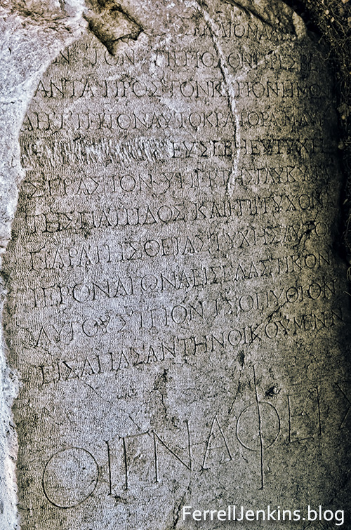
This inscription shows the erasure (blotting or wiping out) of the name of Emperor Marcus Aurelius Antoninus II ) = Elagabalus, A.D. 218-222) on the fifth line from the top. This indicates he was of damnable memory. Note last line – oi gnapheis – the fullers – one of the important trade guilds. Photo by Ferrell Jenkins.

Another inscription from Thyatira has the name of Domitian chiseled off on the fourth or fifth line. You will see the name of Titus Vespasian, the brother of Domitian on the top line.

Thyatira inscripton mentioning Titus and Vespasian, with name of Domitian chiselled off. Photo: ferrelljenkins.blog.

Inscription photographed at Thyatira in 2001. It has the name of Titus Vespasian on the top line, but the name of his brother Domitian (Roman Emperor A.D. 81-96) is erased. Photo by Ferrell Jenkins.

The problems faced by the saints at Thyatira was much the same as those faced by the other churches. Idolatry, the worship of pagan gods, and Emperor worship was a problem they all faced to some degree. Eating meat sacrificed to idols and immorality was also a problem for many of the Christians. Compromise with these more common practices had already been mentioned in the letter to the church at Pergamum where the Old Testament character responsible for leading the saints to compromise was the Old Testament character Balaam. In the letter to the saints at Thyatira the person responsible was a woman who claimed to be a prophetess like Jezebel.

What do we know about the Old Testament Jezebel?

  • She was the daughter of Ethbaal, king of the Sidonians, and a
    devotee to Baal.
  • She supported 450 prophets of Baal and 450 prophets of Asherah.
    It was these prophets of Baal with which Elijah contended on Mount
    Carmel (1 Kings 18).
  • She sought to kill the prophet Elijah (1 Kings 19:2).
  • She had Naboth murdered and confiscated his vineyard at Jezreel (1 Kings 21).

If you have read the Old Testament account you know that Jezebel came under the judgment of the LORD. Both this account and the one in Revelation illustrates the folly of making a concession to error and the practice of immorality.

As mentioned in an earlier post, the situation described in the book of Revelation fits perfectly with what we learn when we read the history of the area and visit the ruins of the ancient cities named in the book.