Category Archives: Travel

The theater at Caesarea Maritima

The theater at Caesarea Maritima was built originally by Herod the Great but was added to and modified in later centuries. The seating capacity in its final stage was about 4,000.

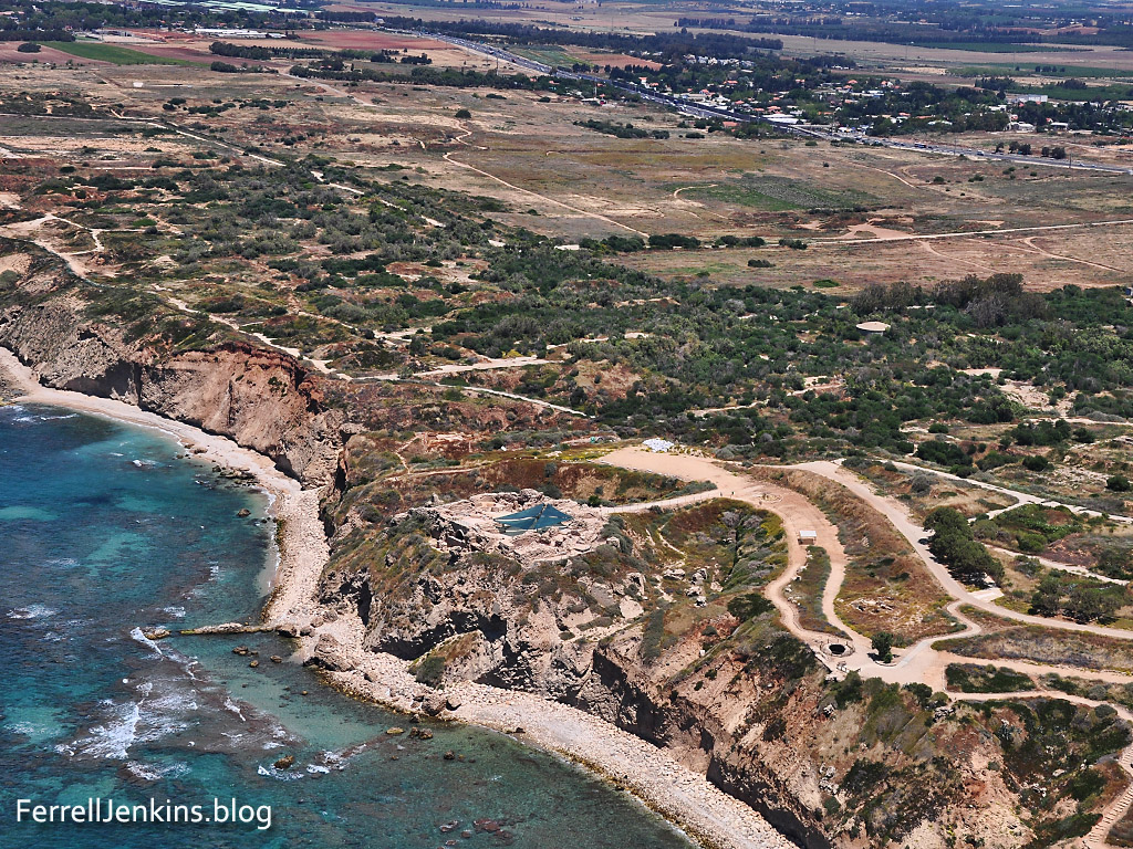
The first aerial photo shows the position of the theater (facing west) in relation to the Mediterranean Sea.

The theater at Caesarea Maritima on the Mediterranean. Photo by Ferrell Jenkins.

The theater at Caesarea Maritima on the Mediterranean. Photo by Ferrell Jenkins.

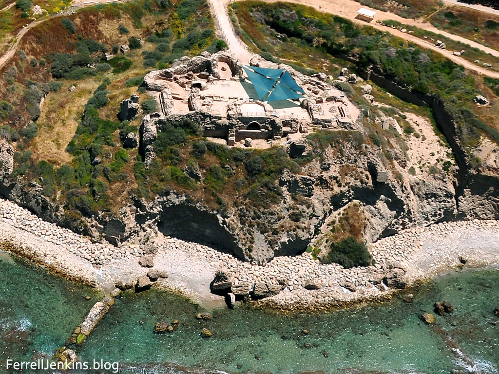
The next photo is an aerial closeup. Most of the seating has been restored since the excavation in the early 1960s.

The theater at Caesarea Maritima. View is South (bottom) to North (top). Photo by Ferrell Jenkins.

View of the theater South (bottom) to North (top). Photo by Ferrell Jenkins.

When we look at the theater from above it appears as a small piece of a model. Musical concerts are held in the restored theater.

King Herod Agrippa I (A.D. 37-44), the grandson of Herod the Great, visited Caesarea. In a dispute with the people of Tyre and Sidon, he put on his royal apparel and addressed them.

On an appointed day Herod, having put on his royal apparel, took his seat on the rostrum and began delivering an address to them. The people kept crying out, “The voice of a god and not of a man!”  And immediately an angel of the Lord struck him because he did not give God the glory, and he was eaten by worms and died. (Acts 12:21-23 NAU)

Josephus informs us that this speech took place in the theater (Ant. 19.344). The NET Bible study notes are helpful in explaining the differences between Luke’s account and that of Josephus. (Scroll down to Acts 12:23 for these notes.)

Josephus, Ant. 19.8.2 (19.343-352), states that Herod Agrippa I died at Caesarea in A.D. 44. The account by Josephus, while not identical to Luke’s account, is similar in many respects: On the second day of a festival, Herod Agrippa appeared in the theater with a robe made of silver. When it sparkled in the sun, the people cried out flatteries and declared him to be a god. The king, carried away by the flattery, saw an owl (an omen of death) sitting on a nearby rope, and immediately was struck with severe stomach pains. He was carried off to his house and died five days later. The two accounts can be reconciled without difficulty, since while Luke states that Herod was immediately struck down by an angel, his death could have come several days later. The mention of worms with death adds a humiliating note to the scene. The formerly powerful ruler had been thoroughly reduced to nothing (cf. Jdt 16:17 ; 2 Macc 9:9; cf. also Josephus, Ant. 17.6.5 [17.168–170], which details the sickness which led to Herod the Great’s death).

We have included two larger images suitable for use in teaching. Just click on the image.

Protecting Israel’s coastline

Last December we reported on damage to Israel’s Mediterranean coastline here (Ashkelon) and here (Caesarea). Now we learn, in an article by Karin Kloosterman, that Israel is spending lots of money to protect the eroding coastline.

A new government initiative worth $135 million will turn about 10 miles of stretches of the Israeli coast into a series of reinforcements and public parks to be enjoyed by locals and tourists. Some of the parks will run through archeological sites of interest.

Kloosterman’s article features the work of geological archaeologist Dr. Beverly Goodman, University of Haifa. Goodman explains the importance of the coastline.

“What we are looking at in Caesarea, on the coastal cliffs, is that we have areas where the coastline has changed so much – and we actually have antiquities that are being eroded into the sea.”

The article says,

Goodman had just finished recording details about the seafloor and archeological remains. After the storm, she returned to her underwater lab to find that some 80 percent of what she’d surveyed had been destroyed or washed away.

You may find a few humorous things in Kloostermann article.

Historically, Israel’s coastal area is important not only for today’s population. According to the Christian Gospels, the Apostle Peter was imprisoned in Caesarea after being arrested in Jerusalem, and an inscription bearing the Christian scriptural name Pontius Pilate was found here.

Our readers will know that it was Peter who first preached the gospel at Caesarea (Acts 10-11), but that it was Paul who was imprisoned at Caesarea (Acts 23-26).

Reporters do have deadlines! Otherwise, the article is fascinating and may be read here.

Our aerial photo, made May 11, shows the main part of Caesarea. The Herodian harbor is on the left. The hippodrome is in the upper center of the photo, and the Roman theater is to the extreme upper right.

Aerial view of Caesarea Maritima. Photo by Ferrell Jenkins.

Aerial view of Caesarea Maritima. Photo by Ferrell Jenkins.

This photo, made April 28, shows some of the damage done to one of the old buildings at the ancient harbor.

Caesarea storm damage from December 2010. Photo by Ferrell Jenkins.

Caesarea storm damage from December 2010. Photo by Ferrell Jenkins.

HT: Joseph Lauer

Apollonoia (Tel Arsuf) and the Plain of Sharon

Apollonia is not mentioned in the Bible, but the site is significant in understanding the land of the Bible. The coastal plain from Tel Aviv north to Haifa is known as the Plain of Sharon. The pasture lands of Sharon were allotted to the tribe of Gad (1 Chronicles 5:16). The plain seems to be mentioned in the account of the healing of Aeneas by Peter at Lydda (the area of modern Lod). Word spread quickly to the residents of Lydda and Sharon.

There he found a man named Aeneas, bedridden for eight years, who was paralyzed.  And Peter said to him, “Aeneas, Jesus Christ heals you; rise and make your bed.” And immediately he rose.  And all the residents of Lydda and Sharon saw him, and they turned to the Lord. (Acts 9:33-35 ESV)

The city at Tel Arsuf was established by the Phoenicians and dedicated to Reshef, the Canaanite god of fire. The Greeks equated Reshef with Apollo and called the city Apollonia (Alon, Israel National Parks & Nature Reserves, 286).

Apollonia was important to the Crusaders near the close of the 12th century and the decades to follow when the Crusaders “established part of their kingdom in the coastal area of the Holy Land, without Jerusalem” (Alon, 287). The fortress and walls from 1241 A.D. are now part of the National Park.

Our first photo shows the coastal plain of Sharon. Notice especially the kurkar ridge along the coast. Israel highway 2 may be seen a short distance inland. You will see Apollonia on the ridge overlooking the sea.

Aerial View of Apollonia and the Plain of Sharon. Photo by Ferrell Jenkins.

Aerial View of Apollonia and the Plain of Sharon. Photo by Ferrell Jenkins.

The second photo shows an aerial close up of the site of Tel Arsuf or Apollonia. This site is being damaged by the sea.

Aerial view of the Crusader fortress of Apollonia. Photo by Ferrell Jenkins.

Aerial view of the Crusader fortress of Apollonia. Photo by Ferrell Jenkins.

Ha’aretz English Language Edition Magazine reports on an exhibition at the Eretz Israel Museum, Tel Aviv, of the “Last Supper at Apollonia.”

Apollonia Final Supper of the Crusaders. Photo: Ha'aretz.

Apollonia Final Supper of the Crusaders exhibition. Photo: Ha’aretz, Leonid Pedrol.

The exhibition offers a first-time look at a collection of Crusader kitchen utensils. The Mameluke siege of the Crusader fortress began in late March 1265. Inhabitants of the area fled to the fortress.

During the few and far-between peaceful times in the Kingdom of Jerusalem, the fortress, built a generation earlier and leased to the Order of the Hospitallers just four years before its fall, was home to about 50 knights and their servants. At the start of the siege, which would go on for many bloody weeks, nearly 2,000 people were crammed into the fortress

Ronit Vered, author of the article, describes the siege.

During the five-week siege, more than 2,700 heavy boulders brought in from the Samaria hills were catapulted at the fortress walls. Some 1,200 iron-tipped arrows were fired at the defenders, and arrows wrapped in cloth and dipped in a flammable material were launched at the drawbridge and the heavy door, which was made of wood and bronze plates. The archers of the Order of the Hospitallers returned fire and even launched clay grenades filled with fiery materials at their enemies, but they had no defense against the tunnels dug by the Mamluks to undermine the wall’s foundations. On Thursday, April 29, the Mamluk fighters seized control of parts of the Arsur wall and raised their flag over it.

The Crusaders lost almost 1,000 men in the battle. Prof. Israel Roll led an excavation of the site in 1999. A cache of Crusader kitchen utensils were found. These are now exhibited for the first time at the Eretz Israel Museum.

The complete fascinating article may be read here. Larger images are available for those who may find them useful. Just click on the image above.

HT: Joseph I. Lauer

Memorial Day 2011

Memorial Day, originally called Decoration Day, is a day of remembrance for those who have died in our nation’s service. There are many stories as to its actual beginnings, with over two dozen cities and towns laying claim to being the birthplace of Memorial Day. (Memorial Day History)

When I was a kid, growing up in the American South, the day we now call Memorial Day was called Decoration Day. Families went to the local cemeteries to clean up the grave sites of relatives and leave fresh flowers. If it was known that there were no family members left in the community, those graves also were cleaned. I don’t recall when I first began to hear, or think, that the day was intended to honor those fallen in war.

Like many holidays, the original purpose has changed. Memorial Day, Independence Day, Labor Day, Christmas, Easter, and other holidays, have become times for picnics, trips, vacations, and assorted non-related practices. Every holiday has become a time for stores to have sales.

I like the idea of Memorial Day. I am pleased to join in the remembrance of troops fallen in battle, and all of the dead who have played a significant role in my life.

I have chosen a photograph that I made at the Gettysburg National Military Park of the monument erected to the men of Florida who fought in the American Civil War.

Gettysburg monument to Floridians who fought in the Civil War. Photo by Ferrell Jenkins.

Gettysburg monument to Floridians who fought in the Civil War. Photo: F. Jenkins.

On July 2 and 3, 1863, the 700 Floridians of Perry’s Brigade suffered 445 casualties. The monument reads this way:

Like all Floridians who participated in the Civil War, they fought with courage and devotion for the ideals in which they believed by their n0ble example of bravery and endurance. They enable us to meet with confidence any sacrifice which confronts us as Americans.

The photo below is another I made on the battlefield. It has been converted to a pencil drawing using a program called Topaz Adjust.

The Gettysburg Battlefield. Photo by Ferrell Jenkins.

The Gettysburg Battlefield. Photo by Ferrell Jenkins.

How good and pleasant it is when brothers live together in harmony! (Psalm 133:1 CSB)

The first portion of this post has been repeated from a year ago.

The sheep of His pasture

The photo we are sharing today is typical of the beautiful scenes in the Shephelah (lowland) of Israel in the spring (Obadiah 1:19). After the grain has been harvested the sheep are led by their shepherd into the fields to graze. The photo today shows the fields and hills between the Valley of Elah and Beit Guvrin to the east of Highway 38. This is near the entry to the Adullam Grove Nature Reserve and Horbat Midras.

Sheep grazing in the Shephelah. Photo by Ferrell Jenkins.

Sheep grazing in the Shephelah. Photo by Ferrell Jenkins.

Numerous biblical references come to mind. Note what the Psalmist said about the role of man in relation to the animals.

You have given him dominion over the works of your hands; you have put all things under his feet, all sheep and oxen, and also the beasts of the field, the birds of the heavens, and the fish of the sea, whatever passes along the paths of the seas. O LORD, our Lord, how majestic is your name in all the earth!  (Psalm 8:6-9 ESV)

Or, the reference to God’s people as the sheep of His pasture.

But we your people, the sheep of your pasture, will give thanks to you forever; from generation to generation we will recount your praise. (Psalm 79:13-1; cf. 100:3 ESV)

Or, perhaps the most familiar of all:

The LORD is my shepherd; I shall not want. (Psalm 23:1 ESV)

A hi-res photo suitable for use in teaching is available by clicking on the image. You can make your own caption across the sky or the grain field.

The Cardo Maximus in Jerusalem

Reconstructing the Jerusalem of the time of Jesus and the Apostles is not as easy as one might think. We have little bits of evidence here and there in basements. I am thinking of the evidence of the pre-70 A.D. ruins such as the Burnt House and the Herodian Mansion. We also have the Herodian Temple Precinct walls, the Temple Mount steps and the street in the Tyropoeon Valley. (This is not intended as a complete list. Just suggestive.)

Some Roman ruins in Jerusalem date to the period after the Bar Kochba revolt in 135 A.D. One impressive site in the Jewish Quarter of the Old City is the Cardo. The Cardo Maximus was the main north-south street running from one end of the city to the other. An east-west street was called the Decumanus Maximus.

The Emperor Hadrian rebuilt Jerusalem and named it Aelia Capitolina. The photo below shows a portion of the Cardo of that city. We see paving stones and columns that ran along the length of the street. A mural has been placed at one portion of the street to illustrate typical life in the city at that time.

The Roman Cardo in Jerusalem. Photo by Ferrell Jenkins.

The Roman Cardo in Jerusalem. Photo by Ferrell Jenkins.

We are reminded of one of the many references Jesus made to the marketplace (Greek, agora).

And in his teaching he said, “Beware of the scribes, who like to walk around in long robes and like greetings in the marketplaces (Mark 12:38 ESV)

Hadrian was Roman Emperor from 117-138 A.D. Streets, arches, and gates were erected in his honor all over the Roman Empire during his reign. The photo below shows the head of a marble statue in the British Museum showing Hadrian in Greek dress. The statue comes from the Temple of Apollo at Cyrene in northern Africa (modern Libya).

Hadrian in Greek Dress. Temple of Apollo, Cyrene. British Museum. Photo by Ferrell Jenkins.

Hadrian in Greek Dress. Temple of Apollo, Cyrene. British Museum. Photo by Ferrell Jenkins.

A larger image of the Cardo scene suitable for use in teaching is available by clicking on the photo.

The Golden Age of Ebla — before the biblical Patriarchs

My only visit to Ebla was in 2002. This means I do not have hi-res photos, except for a few slides that I have had digitized, but I am delighted to have any photos. At the site I picked up a small booklet, Tell Mardikh — Ebla, written by Faja Haj Muhammad that gives a short presentation of the history and remains of the kingdom of ancient Ebla. I will share a couple of photos with some brief info from that book.

The first photo shows the reconstruction of the Palace of the Crown Prince (Palace Q or Western Palace). This palace, built of mud brick, is “located in the lower town, west of the Acropolis.” In the portion of the palace shown here you will see “a well preserved room, used for the grinding of cereals, in order to prepare bread for hundreds of persons.”

Ebla Western Palace Reconstruction. Photo by Ferrell Jenkins.

Ebla Western Palace Reconstruction. Note the grinding stones. Photo by Ferrell Jenkins.

The Royal Archives. In 1975 the excavators discovered a square room west of the Administrative Wing, on the wall, filled with 17,000 clay tablets. The large square tablets had been on shelves. The small round one were found in baskets on the floor.

… the texts were placed according to their subject, and different subjects corresponded to different shapes of tablet.

… There are administrative, economical, historical, judicial, religious texts. The writing is cuneiform. The language is a local language, now called by scholars (Eblaite), which belongs to the same family as Akkadian of Mesopotamia.

Ebla Archives Room. Photo by Ferrell Jenkins.

Ebla Archives Room. Photo by Ferrell Jenkins.

The Western Palace and the Archive are dated to the first golden age of Ebla, 2400–2250 B.C. This is long before the time of Abraham who lived north of Ebla at Haran in Padan Aram for a time. Haran is about 150 miles north of Ebla.

So Abram went, as the LORD had told him, and Lot went with him. Abram was seventy-five years old when he departed from Haran.  (Genesis 12:4 ESV)

Isaac took Rebekah, the daughter of Bethuel the Aramean of Paddan-aram to be his wife (Genesis 25:20). Jacob spent more than two decades in the same area. Most of the children of Jacob (= Israel) were born in the region.

God appeared to Jacob again, when he came from Paddan-aram, and blessed him. (Genesis 35:9 ESV)

When did Abraham live? I don’t want to begin a fight, but I will note several dates suggested by scholars for Abraham.

  • Between 2000 and 1700 B.C. A large number of scholars such as Glueck, Albright, and Wright took this position.
  • 14th Century B.C. This was the view of Cyrus Gordon. (Too late for me.)
  • Born 2165 B.C. The view of John Davis in his excellent book, Paradise to Prison. Davis understands Galatians 3:17 to begin with the arrival of Abraham in Egypt.
  • Born 1950 B.C. This view says Galatians 3:17 is dated from the entrance to Canaan (Genesis 12:4). My inclinations are here.

Now you have something to work on. My only point here is to show that Ebla was a powerful, thriving, economic power long before Abraham. Ebla flourished again in Middle Bronze I-II (1850-1600 B.C.). It is possible that Isaac and Jacob knew of the city.

Ebla and the Ebla Tablets

The Ebla tablets were discovered by an Italian team of excavators at Tell Mardikh in Syria (about 30 miles S of Aleppo) in 1975. More than 17,000 cuneiform tablets were discovered. They date to the mid-third millennium B.C. when Ebla was the capital of a great Canaanite empire. Scholars state that there are important affinities between the Eblaite language and biblical Hebrew, both being members of the Northwest Semitic family.

Ebla - Tell Mardikh - Syria. Photo by Ferrell Jenkins. May, 2002.

Tell Mardikh (Ebla) in Syria. Photo by Ferrell Jenkins, May 2002.

Numerous articles have appeared in the popular press and in scholarly journals stating that the names of Sodom and Gomorrah appear in the Ebla tablets. At one point it was even being said that all five cities of the plain (Gen. 14), and perhaps the name of one of the kings, were mentioned in the tablets. Much controversy has surrounded this discussion. Infighting between the excavator (Paolo Matthiae), the epigrapher (Giovanni Pettinato), and other scholars, along with some political implications, clouded the whole issue.

The late Mitchell Dahood (died 1982), an expert in Ugaritic literature, claimed that the cities of Sodom and Zeboim “may have counterparts” in the Ebla tablets (Giovanni Pettinato, The Archives of Ebla, 287). Pettinato was the first to read and interpret tablets from the Ebla archives and the first to identify the Northwest Semitic language in which they are written. Paolo Matthiae, the archaeologist, says the rumors that there is proof of the historical accuracy of the Bible patriarchs, references to Sodom and Gomorrah, etc. “are tales without foundation” (Ebla: An Empire Rediscovered, 11). One scholar states, “the initial enthusiasm about the light the tablets would shed on the early stages of biblical culture is now mostly seen as exaggerated. Clearly, no biblical personages can be identified in the tablets … ” (Harper’s Bible Dictionary, [1985] 235). Dahood, in the Afterword of Pettinato’s book, commented on the pessimism of one university professor with this classic put down:

How a savant can determine how relevant to the Bible a new discovery may be before the tablets have been published must remain a mystery. (Pettinato, The Archives of Ebla, 273).

Dahood says that the people of Ebla spoke a dialect of Canaanite and that their principal god was Dagan the Canaanite or the Lord of Canaan. This indicates that Canaan extended much further north than previously thought (Pettinato, 272). Dahood cites several biblical passages in which he believes a parallel exists between the Hebrew and Eblaite words (271-321). Numerous names in Genesis find parallel in the Ebla tablets. I had the opportunity to hear Dahood speak on this subject at a professional meeting in Dallas years ago.

Ebla Tablet at Bible Land Museum Jerusalem. Photo by Ferrell Jenkins shortly after the BLMJ opened and photos were permitted.

An Ebla Tablet. BLMJ. Originally the museum allowed photos. Photo by Ferrell Jenkins.

At this point scholars are not agreed on the proper reading of some of the Eblaite words. Perhaps in time we will know more about this. For the present we must wait patiently. Numerous articles about Ebla have appeared in Biblical Archaeologist and Biblical Archaeology Review, as well as other journals.

Word comes regarding the death of Professor Giovanni Pettinato at the age of 77. Details here. HT: Bible Places Blog.

New difficulties on the “Jesus Trail”

We have reported about Larry’s hiking on the “Jesus Trail” from Nazareth to Bethsaida. Larry’s last post was at the end of Day 3. On his trek from Moshav Arbel eastward he encountered a new problem — the strong East winds.

Almost everyone who has visited Israel has learned of the West winds that make their way through the depressions around the Sea of Galilee and create storms on the Sea. Unless you travel in the “transitional season” or in the (dry) summer season you may not have learned about the East wind. This wind is called the sirocco. In Egypt it is known as the khamsin, and in Israel as the sharav.

Denis Baly, The Geography of the Bible (1974 ed., pp. 51-53), explains these winds. He says they occur in the transitional seasons from early April to mid-June (that is now), and from mid-September to the end of October. Baly says,

It is this intense dryness and the fine dust in the air which are so exhausting, for other hot days, though troublesome, do not have the same effect. People with a heart condition, nervous complaints, or sinus trouble are particularly affected, but even the mildest-tempered person is apt to become irritable and to snap at other people for no apparent reason. Tourists find the sirocco especially frustrating, for not only does travel become fatiguing, but the fine yellowish dust which fills the air drains it of all color, blots out all but the immediate vicinity, and makes photography a mockery.

Here is how Larry described his day in an Email to me overnight.

No blog last night because of the storm. I woke to high winds from the east which dusted up the air so badly that photos were mostly useless. Worst part was that it was directly against me and really HOT. Pushing against 20+ mph winds really took the steam out of me. By the end of the day I was utterly exhausted.  Drank my full 3 litres and had good dinners and breakfasts, but energy levels are still very low.

The photo below is one of the aerial shots we made a week ago. It was made while flying over the west shore of the Sea of Galilee, with the view to the west. You can see Mount Arbel and the Wadi Hamam below. The Via Maris runs in this valley which is also called the Valley of the Doves. You will notice two lines of mountains further west.

I am rather sure that this is the route Larry was walking yesterday. Larry has lived in Washington state for many years. I think he is not bothered by the sudden rains, but the intense heat and strong wind from the east may be another matter. I want you to think about the fact that all of the biblical characters from the Patriarchs to Jesus and His disciples encountered conditions similar to these (and worse).

Aerial view of Arbel and the Via Maris. Photo by Ferrell Jenkins.

Aerial view of Arbel, Wadi Hamam, and the Via Maris. Photo by Ferrell Jenkins.

Baly cites several biblical references to the east and south winds that bring in the hot air and the dust storms. He says, “Where the mountains come close to the sea a strong sirocco pours down the slopes like a flood, at 60 miles an hour or more, stirring the sea into a fury.”

By the east wind you shattered the ships of Tarshish. (Psalm 48:7 ESV)

In the prophecy against Tyre, Ezekiel says,

“Your rowers have brought you out into the high seas. The east wind has wrecked you in the heart of the seas. (Ezekiel 27:26 ESV)

Notice Elihu’s comments to Job about the south wind.

Do you know the balancings of the clouds, the wondrous works of him who is perfect in knowledge,  you whose garments are hot when the earth is still because of the south wind?  (Job 37:16-17 ESV)

Jesus also observed the effect of the south wind:

And when you see the south wind blowing, you say, ‘There will be scorching heat,’ and it happens. (Luke 12:55 ESV)

Do you remember Jonah’s problems after enjoying the shade of his plant?

When the sun rose, God appointed a scorching east wind, and the sun beat down on the head of Jonah so that he was faint. And he asked that he might die and said, “It is better for me to die than to live.” (Jonah 4:8 ESV)

Baly calls attention to the effect of the spring siroccos on the crops.

The spring siroccos destroy the winter grass and may damage the crops if they come too soon, and hence they appear constantly in the Bible as a symbol of the impermanence of riches or of human life.

Note these additional references in your own study: Psalm 103:16; Isaiah 40:6-8; Hosea 13:15; Ezekiel 17:10; James 1:11.

When Larry goes back on line I am sure his vivid descriptions of his experience will be well worth reading. Here is the link.

Update: Larry is back in Jerusalem Wednesday evening.

Saul visited a medium at En-Dor (Endor)

En-Dor (or Endor) is a fairly insignificant site. It is now located in the middle of wheat fields and groves. I had seen it from the road, but this time I was able in a car to drive to it and get some better photos. This one shows the low tel, and a wheat field ready for harvest. The view is to the north. Mount Tabor dominates the scene to the right, but it is not visible in this photo. One has to go with the light in making photos.

En-Dor on the shoulder of the Hill of Moreh. Photo by Ferrell Jenkins.

En-Dor on the shoulder of the Hill of Moreh. Photo by Ferrell Jenkins.

Shards of pottery are visible all around, especially in the low areas of the farm road as well as in the plowed field. This is a certain indication of an ancient inhabited site.

Pottery shards at En-Dor. Photo by Ferrell Jenkins.

Pottery shards at En-Dor. Photo by Ferrell Jenkins.

En-Dor was located in the territory of Issachar, but was allotted to the half tribe of Manasseh that settled on the west bank of the Jordan (Joshua 17:11).

The most significant biblical event recorded in connection with En-Dor is the visit of  King Saul to the medium of En-Dor.

The Israelites were gathered with Saul on Mount Gilboa. When Saul saw the Philistines gathered against him in the valley below he was afraid and sought out a medium or necromancer, even though earlier he had them removed from the land. This medium lived over the Hill of Moreh on the northern slopes at En-Dor. This tel is located about 2½ miles south of Mount Tabor on the south and east side of Highway 65. It is easily discernible by the palm trees growing there.

Then Saul said to his servants, “Seek out for me a woman who is a medium, that I may go to her and inquire of her.” And his servants said to him, “Behold, there is a medium at En-dor.” (1 Samuel 28:7 ESV)

Map showing location of En-Dor. Courtesy of BibleAtlas.org.

Map showing location of En-Dor. Courtesy of BibleAtlas.org.