Category Archives: Photography

Better photos of “Jerusalem 1”

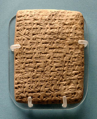
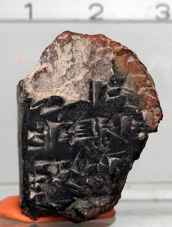
Last week we reported here the announcement of the discovery of a cuneiform fragment dating back to the 14th century B.C. The Hebrew University, Department of Media Relations, has been kind enough to supply me some nice hi-res photos of the cuneiform fragment and the scholars involved in the announcement. Click on each photo for a larger image.
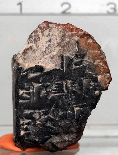
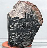
"Jerusalem 1" - the Cuneiform Fragment from the Ophel Excavation.
The Cuneiform Fragment, called Jerusalem 1, from the Ophel Excavation. Photo: Hebrew University/Sasson Tiram.
The fragment found at the Ophel is believed to be contemporary with the some 380 tablets discovered in the 19th century at Amarna in Egypt in the archives of Pharaoh Amenhotep IV (Akhenaten), who lived in the 14th century B.C.E. The archives include tablets sent to Akhenaten by the kings who were subservient to him in Canaan and Syria and include details about the complex relationships between them, covering many facets of governance and society. Among these tablets are six that are addressed from Abdi-Heba, the Canaanite ruler of Jerusalem. The tablet fragment in Jerusalem is most likely part of a message that would have been sent from the king of Jerusalem, possibly Abdi-Heba, back to Egypt, said Mazar.

Examination of the material of the fragment by Prof. Yuval Goren of Tel Aviv University, shows that it is from the soil of the Jerusalem area and not similar to materials from other areas, further testifying to the likelihood that it was part of a tablet from a royal archive in Jerusalem containing copies of tablets sent by the king of Jerusalem to Pharaoh Akhenaten in Egypt.

Mazar says this new discovery, providing solid evidence of the importance of Jerusalem during the Late Bronze Age (the second half of the second century B.C.E.), acts as a counterpoint to some who have used the lack of substantial archeological findings from that period until now to argue that Jerusalem was not a major center during that period. It also lends weight to the importance that accrued to the city in later times, leading up to its conquest by King David in the 10th century B.C.E., she said.
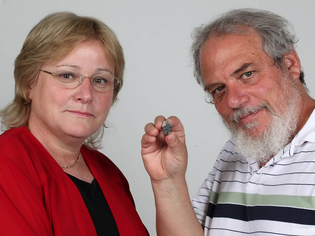
Dr. Eilat Mazar and Prof. Wayne Horowitz with the cuneiform fragment from the Ophel Excavation. Photo: Hebreew University/Sasson Tiram.

Dr. Eilat Mazar and Prof. Wayne Horowitz with the cuneiform fragment from the Ophel Excavation. Photo: Hebrew University/Sasson Tiram.

Note the statement of Dr. Mazar:

The tablet fragment in Jerusalem is most likely part of a message that would have been sent from the king of Jerusalem, possibly Abdi-Heba, back to Egypt, said Mazar.

Several blogs have pointed to the analysis by Professor Christopher Rollston. After an analysis of the fragment, Rollston suggests four possibilities regarding what “Jerusalem 1” could be:

  • Some sort of administrative text.
  • A legal text.
  • An international letter (or a letter from one official to another official in Jerusalem, or to a neighboring city).
  • A literary text of some sort.

He concludes,

Therefore, there are a number of possible options for this tablet.  And, thus, because there is such a dearth of actual preserved text on this tablet, I contend that it is best not to attempt to posit as probable this or that historical context, Sitz im Leben, or genre.  Ultimately, the fact of the matter is that it could be one of various things…e.g., an epistolary text, a legal text, an administrative text, a literary text.

You may read his reflections in their entirety here.
Fragment of Cuneiform tablet found in Jerusalem

The Jerusalem Post reports here the discovery of a fragment of a cuneiform tablet in Jerusalem.

Cuneiform fragment. Photo: Jer.Post.

Cuneiform fragment. Photo: Jerusalem Post.

Hebrew University excavations recently unearthed a clay fragment dating back to the 14th century BCE, said to be the oldest written document ever found in Jerusalem.

The tiny fragment is only 2 cm. by 2.8 cm. in surface area and 1 cm. thick and appears to have once been part of a larger tablet. Researchers say the ancient fragment testifies to Jerusalem’s importance as a major city late in the Bronze Age, long before it was conquered by King David.

The minuscule fragment contains Akkadian words written in ancient cuneiform symbols. Researchers say that while the symbols appear to be insignificant, containing simply the words “you,” “you were,” “them,” “to do,” and “later,” the high quality of the writing indicates that it was written by a highly skilled scribe. Such a revelation would mean that the piece was likely written for tablets that were part of a royal household.

The cuneiform fragment was discovered during wet sifting of the excavation. Prof. Eilat Mazar, director of the dig, said information was not released until last week “because researchers wanted to wait until analysis of the piece was complete so as to be absolutely certain of the details of the find.”

Duane Smith reports that the fragment is published in the current Israel Exploration Journal by Mazar, Horowitz, Oshima, and Goren. The fragment has been dubbed “Jerusalem 1.” The suggestion is made that this fragment may be related to the Amarna tablets sent by rulers of ancient Canaan to the Pharaoh of Egypt in the 14th century B.C.. Smith discusses the fragment in relation to the scribes of the Late Bronze Age Jerusalem here.

Several museums have examples of the Amarna tablets on display. Here is a photo of the letter from Yapahu, king of Gezer. In it he “begs pharaoh for help in defending his city against raids by the Hapiru.”

Amarna Tablet from Gezer. British Museum. Photo: F. Jenkins.

Amarna Tablet from Gezer. British Museum. Photo: F. Jenkins.

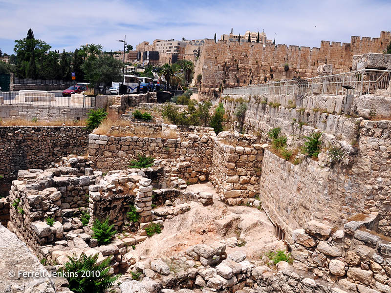
We discussed Mazar’s Ophel Excavation February 23 here. Since that time I have visited Jerusalem and am delighted to share a photo of the area under consideration. Click on the photo for a larger image.

Mazar's Ophel Excavation Area. Photo by Ferrell Jenkins.

Mazar's Ophel Excavation Area. Photo by Ferrell Jenkins.

HT: Joseph I. Lauer; See the Bible Places Blog for more analysis.

Kinneret Regional Project uncovers synagogue

Several weeks ago I added a link to the Kinneret Regional Project on the Bible Places page of the Biblical Studies Info Page. My intention was to write about the project and show a photo of Tel Kinneret (Kinrot; Arabic Tell el-‘Oreme) on the northwestern shore of the Sea of Galilee.

Now word comes of the discovery of a fourth century synagogue at Horvat Kur, about a mile northwest of Tel Kinneret. The press release here says that the discovery “adds new evidence [along with the synagogues at Capernaum, Chorazin, Kh. Hammam, and Magdala] for a very tight net of synagogues in a relatively small area on the Northwestern shores of the Lake of Galilee.”

Todd Bolen created a map using Google Earth to identify Horvat Kur, Tel Chinnereth (Kinneret), Tabgha, Mount of Beatitudes, Cove of the Sower, and Capernaum. This great resource for studying the ministry of Christ may be accessed at the Bible Places Blog.

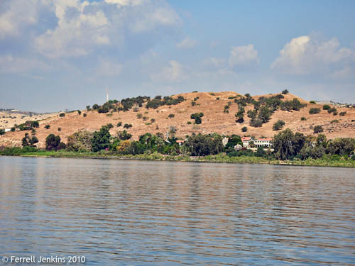
Earlier I mentioned that the day in early May when my group took a boat ride on the Sea of Galilee was a great one for making photos. I caught this wonderful view of Tel Kinneret from the boat. The buildings on the shore below the tel belong to Pilgerhaus Tabgha, a guesthouse operated by the German Association of the Holy Land.

Tel Kinerot from the Sea of Galilee. Photo by Ferrell Jenkins.

Tel Kinneret from the Sea of Galilee. Photo by Ferrell Jenkins.

From the Kinneret Regional Project site you may download several good resources. The 2004 report by Pakkala, et al., begins with this description of Tel Kinneret.

The site boasts remains from the Chalcolithic to the Ottoman period. In its heyday in the Early Iron Age, i.e. the 11th/early 10th century BCE, Kinneret developed into a regional center, controlling the surrounding region and becoming one of the most important urban sites of the country.

The body of water that we commonly call the Sea of Galilee is known as the Sea of Chinnereth in the Old Testament (Numbers 34:11; Joshua 13:27). Chinnereth is listed as one of the fortified cities of the tribe of Naphtali in Joshua 19:35.

I think most tourists to Galilee overlook Tel Kinneret. They are excited about having seen the Roman boat at Nof Ginosaur, and the guide is beginning to tell them about Taghba, Capernaum, or the Mount of Beatitudes. Or it may be because the site is obscured from the highway by the electric power station below it.

HT: Joseph I. Lauer

Reaching 400,000

Moments ago someone recorded hit number 400,000 for this blog. Your words of appreciation are greatly appreciated. In the past few weeks, while traveling on the West Coast, numerous people told me they found the posts helpful. The comments left on the blog, and the Emails received are also appreciated.

400,000 hits at ferrelljenkins.wordpress.com.

Ferrell's Travel Blog recorded his number 400,000 this evening.

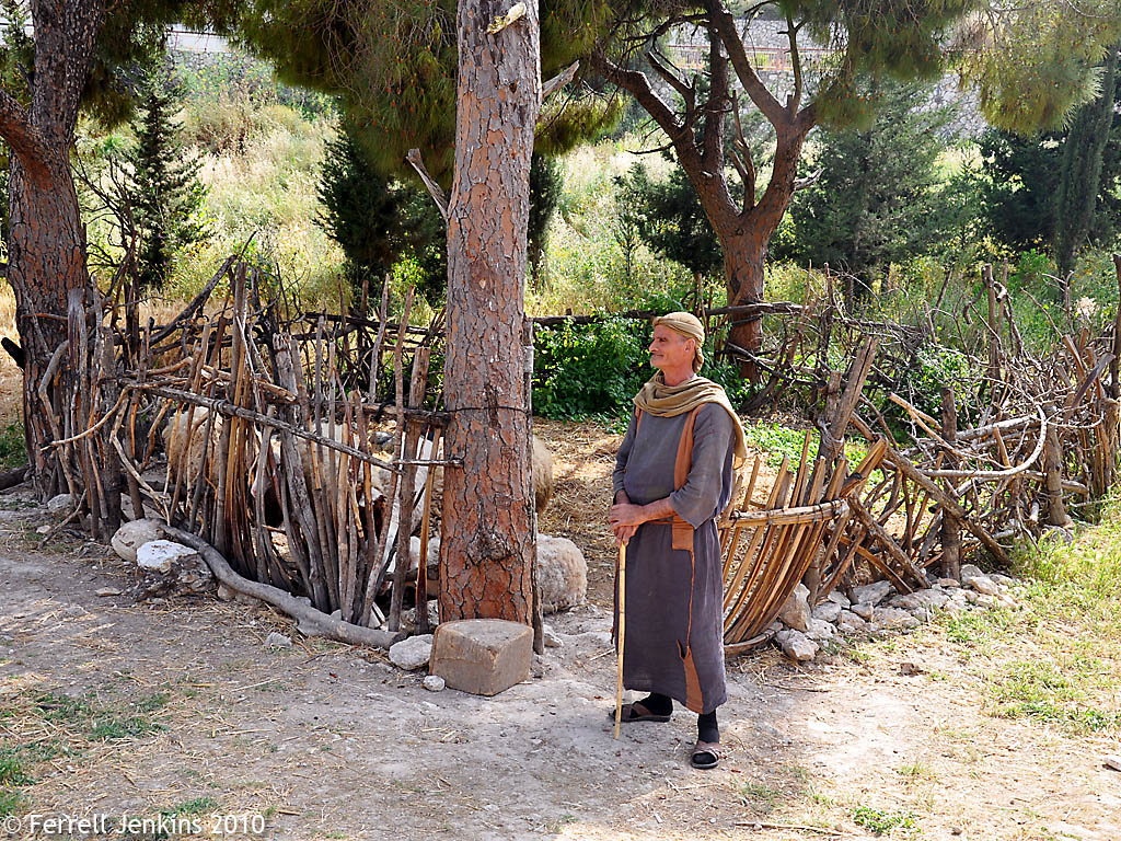
As a marker of this milestone I am posting a photo I think many of you will be able to use in the Bible classes you teach. Click on the photo for a larger image suitable for use in PowerPoint.

Shepherd and sheepfold at Nazareth Village. Photo by Ferrell Jenkins.

Shepherd and sheepfold at Nazareth Village. Photo by Ferrell Jenkins.

This photo might be used in teaching any of the texts mentioning the sheepfold (Genesis 49:14; Numbers 32:16; Judges 5:16; 1 Samuel 24:3; 2 Chronicles 32:28; Psalm 28:13; Psalm 78:70).

It provides a good illustration of the teaching of Jesus in John 10.

“Truly, truly, I say to you, he who does not enter by the door into the fold of the sheep, but climbs up some other way, he is a thief and a robber.  “But he who enters by the door is a shepherd of the sheep. “To him the doorkeeper opens, and the sheep hear his voice, and he calls his own sheep by name and leads them out. (John 10:1-3 NAU)

Freedom is precious

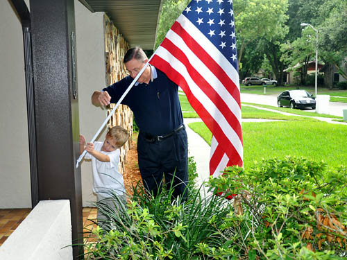
Putting up the flag for July 4, 2010.

Putting up the flag for July 4, 2010.

Excavation begins today at Tel Rehov

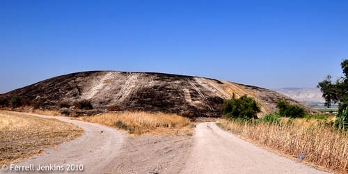
Tel Rehov is located in the Jordan Valley a few miles south of Beth-Shean. The excavation web site describes the tell as one of the largest in the Holy Land. Previous excavations since 1997 reveal that the site was occupied during the Late Bronze Age and Iron Age I. The site is not named in the Bible. The suggestion has been made that it may have remained one of the cities not conquered by the Israelites — like the ones mentioned here:

Yet the people of Manasseh could not take possession of those cities, but the Canaanites persisted in dwelling in that land. Now when the people of Israel grew strong, they put the Canaanites to forced labor, but did not utterly drive them out. (Joshua 17:12-13 ESV)

Rehov is mentioned in Egyptian writings from the time of Pharaoh Shishak, the ruler who invaded Israel during the reign of King Rehoboam about 925 B.C. (1 Kings 14:25).

Last month, while traveling in Israel, I saw that the tell had already been burned off. This is frequently done prior to a dig to help clear it of excess growth. There is always a lot of clean up work that goes on the first few days of a dig.

Tel Rehov. Photo by Ferrell Jenkins.

Tel Rehov with the Jordan Valley in the distance. Photo by Ferrell Jenkins.

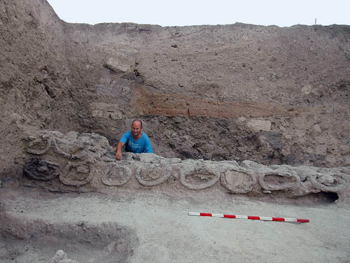
The most exciting discovery that has come from the excavation of Tel Rehov is “the industrial apiary — the only ancient beehives ever discovered in archaeological excavations.”

Tel Rehov. Beehives excavated in 2007.

Beehives Discovered at Tel Rehov in 2007. Archaeologist Amichai Mazar. Photo: Copyright - The Beth-Valley Archaeological Project, Hebrew University of Jerusalem

Read more about the excavation, and hopefully keep up with the current dig, at the web site of the Beth-Shean Valley Archaeological Project here.

Walking through the sewers of first century Jerusalem

The Israel Antiquities Authority announced September 10, 2007 the discovery of a channel that is thought to run from the Temple Mount to the Pool of Siloam, or further.

In excavations the Israel Antiquities Authority is conducting in the City of David in order to expose the main road of Jerusalem from the time of the Second Temple period, the city’s main drainage channel was discovered. According to the writings of Josephus Flavius, the residents of the city fled to this channel at the time of the revolt in order to hide from the Romans.

In excavations the Israel Antiquities Authority is jointly carrying out with the Elad Association in the Walls around Jerusalem National Park, approximately 70 meters of Jerusalem’s main drainage channel from the time of the Second Temple period have been exposed so far. The channel is located along the route from the Temple Mount to the Shiloah Pool. The channel, which passes beneath the main road of the city and apparently continues to Nahal Kidron on its way to the Dead Sea, drained the rainfall of ancient Jerusalem; the Jewish quarter, the western region of the City of David and the Temple Mount.

The complete report may be read here.

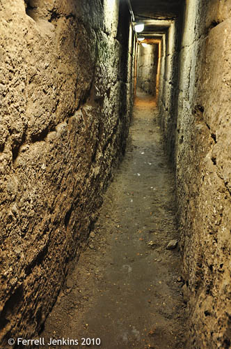
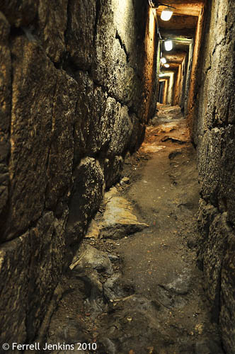
Old news, you say. Here is what is new. My group had the opportunity May 7, 2010, to walk through the channel. Twice before I had walked along a portion of the steps leading uphill from the Pool of Siloam, but this was my first time to walk in through the channel (sewer). It was the first time my local guide had walked through the channel.

Ronnie Reich and Eli Shukron, the excavators, are quoted as saying,

“There is evidence in the writings of Josephus Flavius, the historian who described the revolt, the conquest and the destruction of Jerusalem, that numerous people took shelter in the channel and even lived in it for a period until they succeeded to flee the city through its southern end.”

In some of the media reports this comment includes a reference to The Jewish War. I admit to not being a great Josephus scholar, but I have been unable to locate a specific reference like this in Josephus. He does speak of the citizens of Jerusalem hiding in subterranean caverns of the temple (under the platform, I assume) (5:102), and he mentions secret passages (JW 5:497). If a reader has located the reference to the channel I would be pleased to have it. This does sound like a reasonable suggestion.

This first photo was made closer to the Pool of Siloam.

Roman Period Sewer in Jerusalem. Photo by Ferrell Jenkins.

Roman Period Sewer in Jerusalem. Photo: F. Jenkins.

The next one is closer to the northern end of the current excavation. I would say this is a about half way from the Pool to the Temple Mount. At this point the  channel begins to have the smell of a sewer.

Roman Period Sewer in Jerusalem. Photo by Ferrell Jenkins.

Roman Period Sewer in Jerusalem. Photo: F. Jenkins.

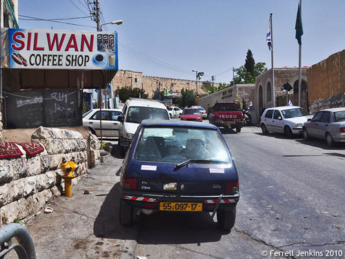
The current channel exits on the west side of the street.

This photo was made as I walked up toward the Temple Mount. You can see the southern wall of the Temple Mount. The building on the right, past the flags, is the entrance to the City of David operated by the Ir David Foundation.

View north toward Temple Mount. Photo by Ferrell Jenkins.

View north toward Temple Mount. Photo by Ferrell Jenkins.

The next photo shows the view to the south toward the Pool of Siloam, and eventually the point at which the Tyropean, Hinnom, and Kidron valleys come together.

View south toward Pool of Siloam. Photo by Ferrell Jenkins.

View south toward Pool of Siloam. Photo by Ferrell Jenkins.

Update: Be sure to read the comment by Tom Powers in which he mentions other possible references from Josephus. You may also find Tom’s articles helpful. See his israelpalestineguide.wordpress.com blog here.

How? When we were looking at the mural showing a reconstruction of the Pool of Siloam, our guide (Elie) started to go back the way we entered. An elderly gentlemen who was selling booklets said we could now go through the channel. Fortunately he was correct!

The first cataract of the Nile

Aswan is the location of the first cataract of the Nile River. This made it an ideal location for the Aswan Dam which was built between 1898 and 1902. This created a small lake south of the dam, but it was nothing to compare with Lake Nasser which has been formed as a result of the building of the new high dam at Aswan between 1960 and 1971.

The new high dam was constructed at a time when the Soviet Union was providing technical, economic and military support to Egypt. I remember staying in a hotel in Egypt in 1973 filled with Soviet tourists. In the years following we saw none of them. Lake Nasser stretches south for more than 300 miles. Many of the Nubians who lived in this area were resettled by the Egyptian government.

Our photo was made below the new high dam from a Nubian settlement. Click on the photo for a larger image.

The first cataract of the Nile at Aswan. Photo by Ferrell Jenkins.

The first cataract of the Nile at Aswan. Photo by Ferrell Jenkins.

Some scholars identify the Arabic name Aswan with the Syene of Ezekiel 29:10 and 30:6. It may be identified with the Sinim of Isaiah 49:12.

I am against you and your waterways. I will turn the land of Egypt into an utter desolate ruin from Migdol to Syene, as far as the border with Ethiopia. (Ezekiel 29:10 NET)

The Hebrew word translated Ethiopia (or Cush) in some English versions is Kush (Cush).

Look, they come from far away! Look, some come from the north and west, and others from the land of Sinim! (Isaiah 49:12 NET)

The Text Critical note in the NET Bible explains,

The MT reads “Sinim” here; the Dead Sea Scrolls read “Syene,” a location in Egypt associated with modern Aswan. A number of recent translations adopt this reading: “Syene” (NAB, NRSV); “Aswan” (NIV); “Egypt” (NLT).

Sadat of Egypt died in the pursuit of peace

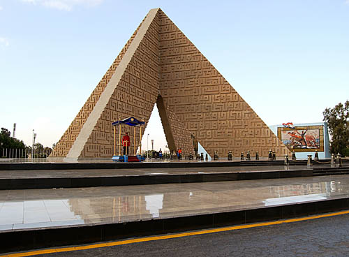
My schedule is full, but I ran across this photo that I thought I would share. Anwar El Sadat was the third president of Egypt in modern times. He served from 1970 until his assassination October 6, 1981. Sadat made peace with Israel on March 26, 1979.

This photo shows the beautiful monument to Sadat that stands across the street from the viewing stands where he was assassinated.

Sadat Monument in Cairo. Photo by Ferrell Jenkins.

Sadat Monument in Cairo. Photo by Ferrell Jenkins.

Dead Sea Scrolls: the French connection

Bloomberg reports on the exhibition of the Dead Sea Scrolls at the National Library (Bibliothèque nationale de France) in Paris with a discussion of the French connection and the problems posed by the scrolls. Jorg von Uthmann says,

The discovery of the Dead Sea Scrolls in 1947 was, along with the opening of Tutankhamun’s tomb in 1922, the greatest archaeological sensation of the 20th century. An exhibition at Paris’s National Library puts the scrolls in their historical and theological context and questions the mainstream hypothesis about their origin.

It’s the first show of this kind in France. That’s all the more amazing as French scholars were deeply involved in the deciphering of the scrolls and the tens of thousands of fragments on papyrus or parchment.

Most of the work was done at the Ecole Biblique et Archeologique in Jerusalem under the direction of the Dominican archaeologist Father Roland de Vaux.

To fund excavations at Khirbet Qumran on the western shore of the Dead Sea, De Vaux sold, in 1953, 377 fragments to the French government. Presented in airtight cases, they occupy the center of the theatrically staged show.

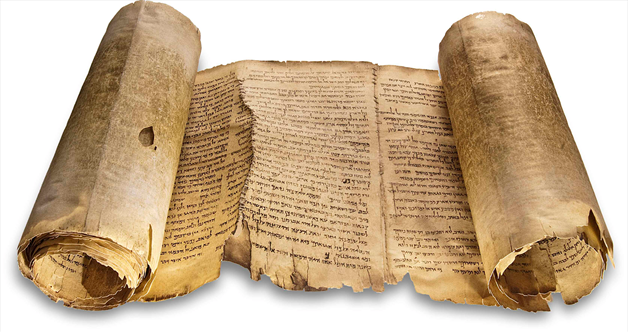
The complete article may be read here. The link to the National Library in Paris is here. The Bloomberg article includes three nice photos, including this one of a facsimile of the Isaiah scroll.

Facsimile of the Dead Sea Isaiah. National Libary via Bloomberg.com.

Facsimile of the Dead Sea Isaiah. National Library via Bloomberg.com.

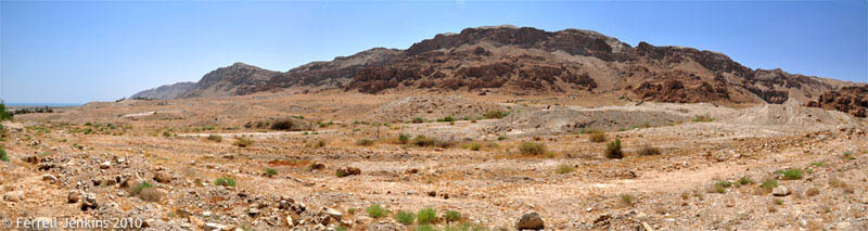
About two weeks ago I was at Qumran and tried my eye and hand at making a panorama of the area immediately to the west of Qumran. In this photo, made of three images, you can see the Dead Sea on the left. The Qumran settlement is on the plateau to the right of the sea. As you enter, or leave, the Qumran parking lot you will see a sign pointing to Kalya.  These photo were made from that road. Click the image for a slightly larger photo.

Qumran Panorama by Ferrell Jenkins.

Qumran Panorama. Photo by Ferrell Jenkins.

About two months ago Todd Bolen identified the caves associated with the Scrolls. For high resolution photos of this same area see here.

HT: Joseph I. Lauer