Category Archives: New Testament

A new tomb at Nazareth Village

Nazareth Village has become a necessary stop on my tours to Israel. The eyes of ministers and Bible class teachers are opened quickly to the reality of Bible stories. Some of the “exhibits” change with the season; others remain constant.

There was something new at Nazareth Village this year — a tomb cut out of the rock with a rolling stone.

New tomb with rolling stone at Nazareth Village. Photo by Ferrell Jenkins.

New tomb with rolling stone at Nazareth Village. Photo by Ferrell Jenkins.

This new tomb “where no one had yet been buried” is a good reminder of the type of tomb in which Jesus was buried (John 19:41 NET).

After Joseph bought a linen cloth and took down the body, he wrapped it in the linen and placed it in a tomb cut out of the rock. Then he rolled a stone across the entrance of the tomb.  (Mark 15:46 NET)

An image suitable for use in teaching is available by clicking on the photo above.

Herodium and the tomb of Herod the Great

Shmuel Browns has an article in Popular Archaeology on “Netzer’s Legacy: The Wonders of Herodium” here. One of the comments by Browns caught my attention as being especially important for all of us who use photos in our teaching.

When visiting an archaeological site, one often cannot see the artifacts that were discovered there as they have been removed and are displayed at a museum.

Browns gives an illustration of part of the Roman bath from the lower city at Herodium. I often think about how important it is to be at an archaeological site at just the right time. When I visited the Herodium in January, and again in May, this is what I saw at the place of Netzer’s most recent work.

Herodium - Place of Herod's Mausoleum. Photo by Ferrell Jenkins.

Herodium - Place of Herod's Mausoleum. View to the East. Photo by Ferrell Jenkins.

How disappointing. My thought is that some day the Antiquities department will have this site prepared for visitors. Until then…

Herod's Tomb. Shmuel Browns.

Herod's Tomb. View to NW. Shmuel Browns.

Browns has a couple of nice photos of the Mausoleum as it looks under the tin roof. I am including a thumbnail of one of his photos to encourage you to go to the article. A site begins to look different after the winter rains. Unless it is continually cleaned (which requires money), it deteriorates quickly.

Herod the Great is known in Scripture as the wicked king who inquired about the birth of Jesus in order to eliminate any opposition to the throne.

After Jesus was born in Bethlehem in Judea, in the time of King Herod, wise men from the East came to Jerusalem  saying, “Where is the one who is born king of the Jews? For we saw his star when it rose and have come to worship him.”  When King Herod heard this he was alarmed, and all Jerusalem with him.  After assembling all the chief priests and experts in the law, he asked them where the Christ was to be born. (Matthew 2:1-4 NET)

Joseph, Mary, and Jesus did not stop to see the tomb of Herod on their return from Egypt.

But when he heard that Archelaus was reigning over Judea in place of his father Herod, he was afraid to go there. After being warned in a dream, he went to the regions of Galilee.  He came to a town called Nazareth and lived there. (Matthew 2:22-23a NET)

Chris McKinny recently posted a paper on “The Growth of Herod’s Kingdom” at Seeking a Homeland here. The well-documented paper includes maps and charts.

Tom Powers reported in February that the Israel Post has issued a series of stamps featuring Herod’s building projects. Click here for photos of the beautiful stamps.

HT: Bible Places Blog.

Where at Caesarea did Herod Agrippa die?

In response to our recent post on the theater at Caesarea Maritima (here), a friend asks, “I was wondering, do you put any stock in Todd Bolen’s contention that the Agrippa I death event happened in the sea side amphitheater, rather than in the theater?”

Boy, am I embarrassed. It is great to have knowledgeable friends, though. I read Todd’s insightful article at The Bible and Interpretation site in July 2010. I was impressed with the article and intended to call attention to it on this blog. For a variety of reasons I failed to get to it, and then let it slip my mind.

The Bolen article challenges Josephus’s location for the place of Herod Agrippa’s death. Here is the synopsis of the argument.

The death of Herod Agrippa I occurred in Caesarea according to both Josephus and the book of Acts. Josephus writes that the king was in the theater when the crowd hailed him as a god and he was struck down. Details in Josephus’s account, however, indicate that the episode occurred in the city amphitheater next door to the temple where the emperor was worshipped.

The article is already too concise and well documented for me to recount the arguments. Bolen believes “that Josephus’s designation of the location was inaccurate. Analysis of his account indicates that the amphitheater, rather than the theater, was the setting for Herod’s public address.” There are four indications showing the Josephus was inaccurate.

  1. The time of day.
  2. The occasion of Agrippa’s death.
  3. An encounter between Pilate and a large crowd a decade earlier.
  4. Josephus’s imprecise use of terms designating buildings of entertainment.

The article may be read in its entirety here. Several informed comments have been added by readers. There are several nice aerial photos with identifications.

The photo below shows the amphitheater (commonly called the hippodrome) running parallel with the coastline. I note that Murphy-O’Connor refers to this as the “Herodian amphitheatre.” At the right (south) bottom of the photo you will see the upper level of what he calls the “Palace of the Procurators.” The Roman theater, which is pictured in our previous post, is to the right of this scene.

Caesarea amphitheater (hippodrome). Photo by Ferrell Jenkins.

Caesarea amphitheater (hippodrome). Photo by Ferrell Jenkins.

Along the top of the photo, under the wing of the plane, is the later amphitheater (or hippodrome) dating to the late Roman period. A line of trees provides a good outline of the structure.

Here in 306 the emperor Maximinus had Christian martyrs executed before him. Its stones were robbed out when Christianity suppressed such bloody and brutal entertainment. (Murphy-O’Connor, The Holy Land, 5th ed., 248)

The Herodian harbor is located to the left (north) of this photo.

The theater at Caesarea Maritima

The theater at Caesarea Maritima was built originally by Herod the Great but was added to and modified in later centuries. The seating capacity in its final stage was about 4,000.

The first aerial photo shows the position of the theater (facing west) in relation to the Mediterranean Sea.

The theater at Caesarea Maritima on the Mediterranean. Photo by Ferrell Jenkins.

The theater at Caesarea Maritima on the Mediterranean. Photo by Ferrell Jenkins.

The next photo is an aerial closeup. Most of the seating has been restored since the excavation in the early 1960s.

The theater at Caesarea Maritima. View is South (bottom) to North (top). Photo by Ferrell Jenkins.

View of the theater South (bottom) to North (top). Photo by Ferrell Jenkins.

When we look at the theater from above it appears as a small piece of a model. Musical concerts are held in the restored theater.

King Herod Agrippa I (A.D. 37-44), the grandson of Herod the Great, visited Caesarea. In a dispute with the people of Tyre and Sidon, he put on his royal apparel and addressed them.

On an appointed day Herod, having put on his royal apparel, took his seat on the rostrum and began delivering an address to them. The people kept crying out, “The voice of a god and not of a man!”  And immediately an angel of the Lord struck him because he did not give God the glory, and he was eaten by worms and died. (Acts 12:21-23 NAU)

Josephus informs us that this speech took place in the theater (Ant. 19.344). The NET Bible study notes are helpful in explaining the differences between Luke’s account and that of Josephus. (Scroll down to Acts 12:23 for these notes.)

Josephus, Ant. 19.8.2 (19.343-352), states that Herod Agrippa I died at Caesarea in A.D. 44. The account by Josephus, while not identical to Luke’s account, is similar in many respects: On the second day of a festival, Herod Agrippa appeared in the theater with a robe made of silver. When it sparkled in the sun, the people cried out flatteries and declared him to be a god. The king, carried away by the flattery, saw an owl (an omen of death) sitting on a nearby rope, and immediately was struck with severe stomach pains. He was carried off to his house and died five days later. The two accounts can be reconciled without difficulty, since while Luke states that Herod was immediately struck down by an angel, his death could have come several days later. The mention of worms with death adds a humiliating note to the scene. The formerly powerful ruler had been thoroughly reduced to nothing (cf. Jdt 16:17 ; 2 Macc 9:9; cf. also Josephus, Ant. 17.6.5 [17.168–170], which details the sickness which led to Herod the Great’s death).

We have included two larger images suitable for use in teaching. Just click on the image.

Protecting Israel’s coastline

Last December we reported on damage to Israel’s Mediterranean coastline here (Ashkelon) and here (Caesarea). Now we learn, in an article by Karin Kloosterman, that Israel is spending lots of money to protect the eroding coastline.

A new government initiative worth $135 million will turn about 10 miles of stretches of the Israeli coast into a series of reinforcements and public parks to be enjoyed by locals and tourists. Some of the parks will run through archeological sites of interest.

Kloosterman’s article features the work of geological archaeologist Dr. Beverly Goodman, University of Haifa. Goodman explains the importance of the coastline.

“What we are looking at in Caesarea, on the coastal cliffs, is that we have areas where the coastline has changed so much – and we actually have antiquities that are being eroded into the sea.”

The article says,

Goodman had just finished recording details about the seafloor and archeological remains. After the storm, she returned to her underwater lab to find that some 80 percent of what she’d surveyed had been destroyed or washed away.

You may find a few humorous things in Kloostermann article.

Historically, Israel’s coastal area is important not only for today’s population. According to the Christian Gospels, the Apostle Peter was imprisoned in Caesarea after being arrested in Jerusalem, and an inscription bearing the Christian scriptural name Pontius Pilate was found here.

Our readers will know that it was Peter who first preached the gospel at Caesarea (Acts 10-11), but that it was Paul who was imprisoned at Caesarea (Acts 23-26).

Reporters do have deadlines! Otherwise, the article is fascinating and may be read here.

Our aerial photo, made May 11, shows the main part of Caesarea. The Herodian harbor is on the left. The hippodrome is in the upper center of the photo, and the Roman theater is to the extreme upper right.

Aerial view of Caesarea Maritima. Photo by Ferrell Jenkins.

Aerial view of Caesarea Maritima. Photo by Ferrell Jenkins.

This photo, made April 28, shows some of the damage done to one of the old buildings at the ancient harbor.

Caesarea storm damage from December 2010. Photo by Ferrell Jenkins.

Caesarea storm damage from December 2010. Photo by Ferrell Jenkins.

HT: Joseph Lauer

Friday’s findings

Looking for Joshua’s Ai. Gary Byers, administrative director of the Khirbet el-Maqatir excavation, has already posted info on six days of the dig. Because I assume this series will continue, I suggest you begin with Day One here. The expedition has posted photos on Facebook here. This will give prospective diggers some idea what goes on during a dig. Information about the purpose of the dig, a project of the Associates for Biblical Research, is posted here. Dr. Bryant Wood, and others associated with this dig, are looking for an alternative site for Ai.

Hidden Pyramids. Dr. Zahi Hawass has called in question the BBC program about the work of Dr. Sarah Parcak using satellite imagery to discover 17 new pyramids and other structures.

Although satellite imaging is useful for discovering new sites and monuments, interpretation of the images is not straightforward. No one can say with certainty that the features displayed under the sand are actually pyramids. Such anomalies could be houses, tombs, temples, pyramids, buried cities or even geological features. The only way we can definitely identify what is there is by excavating it – by investigating it physically. This was not made clear in the article.

Read the complete article here. See our earlier report here.

Corinth Matters. David Pettegrew, assistant Professor of History at Messiah College near Harrisburg, PA., has started a blog called Corinth Matters. Pettegrew completed a dissertation on Corinth on the Isthmus. The new blog deals with the ancient city of Corinth, the Isthmus, the Diolkos, and other things Corinthian. You will find readings lists, links to conferences, info on excavations, maps and images relating to Corinth and the Corinthian correspondence.

Dr. Pettegrew currently is traveling in Albania, the location of ancient Illyricum, visiting Corinthian colonies from the pre-Christian period. Paul made reference to preaching as far as Illyricum.

by the power of miraculous signs and wonders, and by the power of God’s Spirit. As a result, I have fully proclaimed the good news about the Messiah from Jerusalem all the way around to Illyricum. (Romans 15:19 CSB)

Corinth Canal - Photo by Ferrell Jenkins.

A ship is towed through the Corinth Canal. View west toward the Gulf of Corinth. Photo by Ferrell Jenkins.

Having taught the Corinthian correspondence for several year, I find this blog especially interesting.

Contemplating the power of a single grain

Last Sunday evening I heard a good sermon based on John 12:24-26.

Truly, truly, I say to you, unless a grain of wheat falls into the earth and dies, it remains alone; but if it dies, it bears much fruit. (John 12:24 ESV)

This simple statement by Jesus is followed by a difficult lesson.

Whoever loves his life loses it, and whoever hates his life in this world will keep it for eternal life. If anyone serves me, he must follow me; and where I am, there will my servant be also. If anyone serves me, the Father will honor him. (John 12:25-26 ESV)

A grain of wheat must fall into the earth and die before it can produce fruit. Depending on the circumstances the grain can produce thirty-, sixty-, or a hundredfold (Matthew 13:8).

Wheat ready for harvest at En Dor. Photo by Ferrell Jenkins.

Wheat ready for harvest at En Dor. Photo by Ferrell Jenkins.

A single grain of wheat must die in order to produce much fruit. Jesus spoke of the necessity of His own death, and taught the tough lesson of giving up one’s life to serve Him.

Note the comment by William Hendriksen.

The illustration was very clear, especially at the moment when it was spoken, not more than a few days before the (religious and) harvest feast of Passover. The kernels or seeds had been entrusted to the soil. As seeds they had died. But by means of this very process of dissolution they had brought forth an abundant harvest. If a seed is not sown, it remains alone, producing no fruit. So also if Jesus does not die, he will remain alone, without spiritual fruit (souls saved for eternity). His death, however, will result in a rich, spiritual harvest. (New Testament Commentary : Exposition of the Gospel According to John).

We have included a larger image suitable for use in teaching. It is available by clicking on the image above.

Apollonoia (Tel Arsuf) and the Plain of Sharon

Apollonia is not mentioned in the Bible, but the site is significant in understanding the land of the Bible. The coastal plain from Tel Aviv north to Haifa is known as the Plain of Sharon. The pasture lands of Sharon were allotted to the tribe of Gad (1 Chronicles 5:16). The plain seems to be mentioned in the account of the healing of Aeneas by Peter at Lydda (the area of modern Lod). Word spread quickly to the residents of Lydda and Sharon.

There he found a man named Aeneas, bedridden for eight years, who was paralyzed.  And Peter said to him, “Aeneas, Jesus Christ heals you; rise and make your bed.” And immediately he rose.  And all the residents of Lydda and Sharon saw him, and they turned to the Lord. (Acts 9:33-35 ESV)

The city at Tel Arsuf was established by the Phoenicians and dedicated to Reshef, the Canaanite god of fire. The Greeks equated Reshef with Apollo and called the city Apollonia (Alon, Israel National Parks & Nature Reserves, 286).

Apollonia was important to the Crusaders near the close of the 12th century and the decades to follow when the Crusaders “established part of their kingdom in the coastal area of the Holy Land, without Jerusalem” (Alon, 287). The fortress and walls from 1241 A.D. are now part of the National Park.

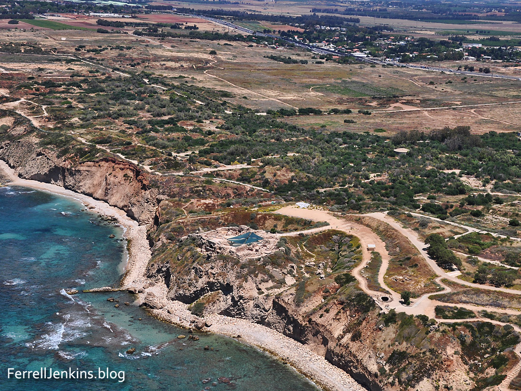
Our first photo shows the coastal plain of Sharon. Notice especially the kurkar ridge along the coast. Israel highway 2 may be seen a short distance inland. You will see Apollonia on the ridge overlooking the sea.

Aerial View of Apollonia and the Plain of Sharon. Photo by Ferrell Jenkins.

Aerial View of Apollonia and the Plain of Sharon. Photo by Ferrell Jenkins.

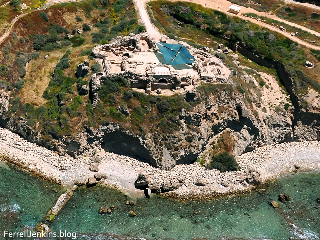
The second photo shows an aerial close up of the site of Tel Arsuf or Apollonia. This site is being damaged by the sea.

Aerial view of the Crusader fortress of Apollonia. Photo by Ferrell Jenkins.

Aerial view of the Crusader fortress of Apollonia. Photo by Ferrell Jenkins.

Ha’aretz English Language Edition Magazine reports on an exhibition at the Eretz Israel Museum, Tel Aviv, of the “Last Supper at Apollonia.”

Apollonia Final Supper of the Crusaders. Photo: Ha'aretz.

Apollonia Final Supper of the Crusaders exhibition. Photo: Ha’aretz, Leonid Pedrol.

The exhibition offers a first-time look at a collection of Crusader kitchen utensils. The Mameluke siege of the Crusader fortress began in late March 1265. Inhabitants of the area fled to the fortress.

During the few and far-between peaceful times in the Kingdom of Jerusalem, the fortress, built a generation earlier and leased to the Order of the Hospitallers just four years before its fall, was home to about 50 knights and their servants. At the start of the siege, which would go on for many bloody weeks, nearly 2,000 people were crammed into the fortress

Ronit Vered, author of the article, describes the siege.

During the five-week siege, more than 2,700 heavy boulders brought in from the Samaria hills were catapulted at the fortress walls. Some 1,200 iron-tipped arrows were fired at the defenders, and arrows wrapped in cloth and dipped in a flammable material were launched at the drawbridge and the heavy door, which was made of wood and bronze plates. The archers of the Order of the Hospitallers returned fire and even launched clay grenades filled with fiery materials at their enemies, but they had no defense against the tunnels dug by the Mamluks to undermine the wall’s foundations. On Thursday, April 29, the Mamluk fighters seized control of parts of the Arsur wall and raised their flag over it.

The Crusaders lost almost 1,000 men in the battle. Prof. Israel Roll led an excavation of the site in 1999. A cache of Crusader kitchen utensils were found. These are now exhibited for the first time at the Eretz Israel Museum.

The complete fascinating article may be read here. Larger images are available for those who may find them useful. Just click on the image above.

HT: Joseph I. Lauer

The Cardo Maximus in Jerusalem

Reconstructing the Jerusalem of the time of Jesus and the Apostles is not as easy as one might think. We have little bits of evidence here and there in basements. I am thinking of the evidence of the pre-70 A.D. ruins such as the Burnt House and the Herodian Mansion. We also have the Herodian Temple Precinct walls, the Temple Mount steps and the street in the Tyropoeon Valley. (This is not intended as a complete list. Just suggestive.)

Some Roman ruins in Jerusalem date to the period after the Bar Kochba revolt in 135 A.D. One impressive site in the Jewish Quarter of the Old City is the Cardo. The Cardo Maximus was the main north-south street running from one end of the city to the other. An east-west street was called the Decumanus Maximus.

The Emperor Hadrian rebuilt Jerusalem and named it Aelia Capitolina. The photo below shows a portion of the Cardo of that city. We see paving stones and columns that ran along the length of the street. A mural has been placed at one portion of the street to illustrate typical life in the city at that time.

The Roman Cardo in Jerusalem. Photo by Ferrell Jenkins.

The Roman Cardo in Jerusalem. Photo by Ferrell Jenkins.

We are reminded of one of the many references Jesus made to the marketplace (Greek, agora).

And in his teaching he said, “Beware of the scribes, who like to walk around in long robes and like greetings in the marketplaces (Mark 12:38 ESV)

Hadrian was Roman Emperor from 117-138 A.D. Streets, arches, and gates were erected in his honor all over the Roman Empire during his reign. The photo below shows the head of a marble statue in the British Museum showing Hadrian in Greek dress. The statue comes from the Temple of Apollo at Cyrene in northern Africa (modern Libya).

Hadrian in Greek Dress. Temple of Apollo, Cyrene. British Museum. Photo by Ferrell Jenkins.

Hadrian in Greek Dress. Temple of Apollo, Cyrene. British Museum. Photo by Ferrell Jenkins.

A larger image of the Cardo scene suitable for use in teaching is available by clicking on the photo.

Fields white for harvest

Many biblical accounts contain information not easily understood without some knowledge of the history and culture of the time. Such is true in the account of Jesus traveling through Samaria in John 4. You probably recall that He met the woman of Samaria when she came to the well to draw water.

While His disciples were in the city buying food Jesus taught the Samaritan woman. She then went into the city and began to tell the men that she had met this man who knew her intimate life.

When the disciples returned to Jesus He said,

Do you not say, ‘There are yet four months, then comes the harvest’? Look, I tell you, lift up your eyes, and see that the fields are white for harvest. (John 4:35 ESV)

This is one of those statements with a literal meaning as well as a spiritual one. What did he mean by four months? Four months separate the sowing and the harvesting. Barley harvest could begin around April 15. Wheat harvesting begins six weeks later in late May or early June. In May the fields would be white unto harvest. This helps to date the episode in John 4 to December or January, depending on whether the crop was barley or wheat.

When Jesus said the fields were white for harvest He was speaking of a spiritual harvest. The disciples did not know that He and the woman had already sowed the seed. They would reap the harvest. It is not inappropriate to see the harvesting in the two days Jesus stayed there teaching (John 4:39-43), or in the later events of Acts 8:39-43.

The photo below was made from En-Dor, looking north to Mount Tabor. The wheat fields are almost ready for harvesting.

Wheat ready for harvest at En-Dor near Mount Tabor. Photo by Ferrell Jenkins.

Wheat ready for harvest at En-Dor near Mount Tabor. Photo by Ferrell Jenkins.

Under some light the fields even have a white appearance, as you see in the photo below.

Wheat ready for harvest near En-Dor and Mount Tabor. May 13. Photo by Ferrell Jenkins.

Wheat white for harvest. May 13. Photo by Ferrell Jenkins.

These little tips, scattered here and there in Scripture, reveal much about the daily life and culture of Bible times.