Category Archives: New Testament

Girding up the loins of your mind

The Apostle Simon Peter followed Jesus during His personal ministry. It is not surprising that some of the illustrations he uses come from this experience. In 1 Peter 1:13 the apostle wrote,

Therefore gird up the loins of your mind, be sober, and rest your hope fully upon the grace that is to be brought to you at the revelation of Jesus Christ; (1 Peter 1:13 NKJ).

The Louw-Nida Lexicon says that the Greek phrase used in 1 Peter 1:13 is “(an idiom, literally ‘to bind up the loins of the mind’) to prepare oneself for learning and thinking – ‘to get one’s mind ready for action, to be ready to learn and to think, to be alert.” The Greek phrase is translated this way: ‘so then, have your minds ready for action.1 Peter 1:13.” (27:55)

In The IVP Bible Background Commentary, Craig Keener writes,

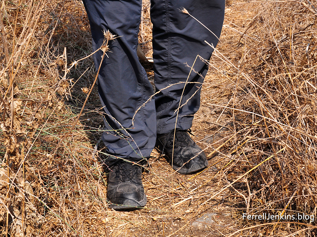
Men wore long robes and would tuck them into their belt, “gird up their loins,” so they could move more freely and quickly. Although the image also occurs elsewhere in the Old Testament, here Peter may specifically allude to the Passover (Exodus 12:11): once God’s people had been redeemed by the blood of the lamb (1 Peter 1:19), they were to be ready to follow God forth until he had brought them safely into their inheritance (cf. 1:4), the Promised Land.”

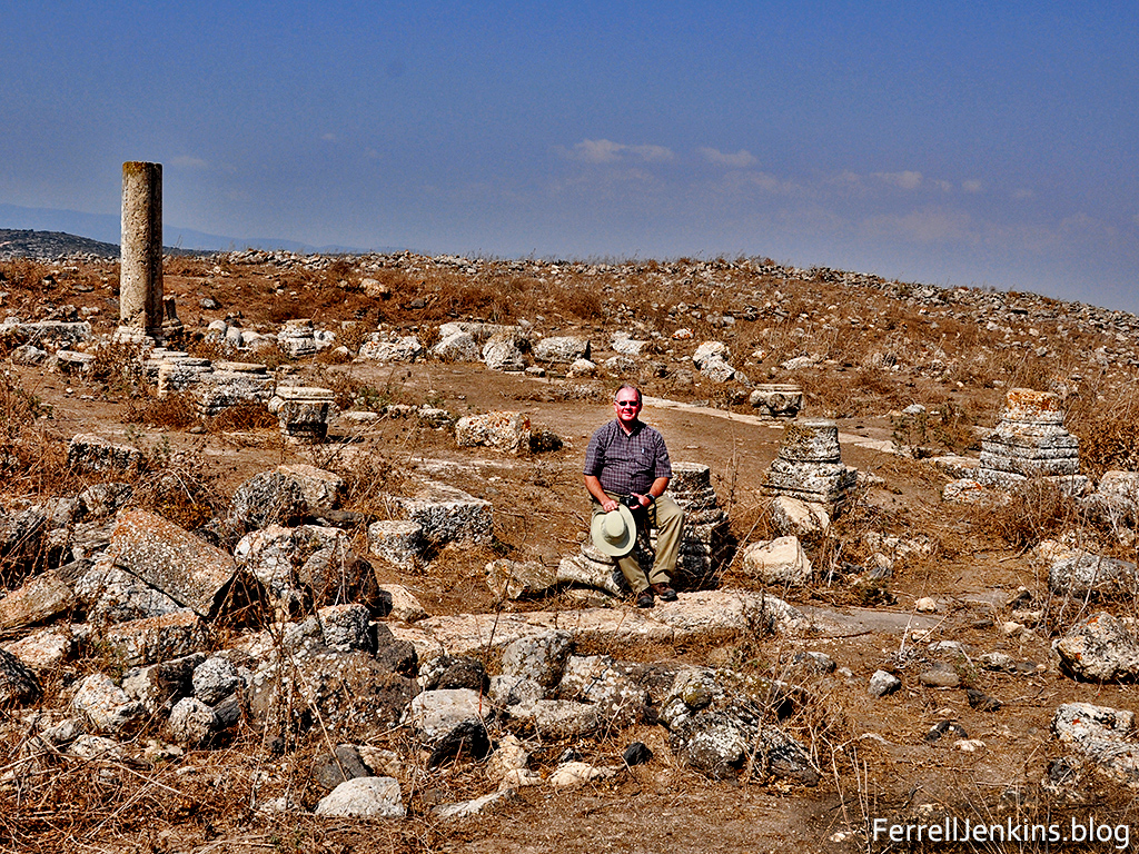
Even though I have never worn a long, flowing robe I could illustrate this over and over from my years of travel in Israel. Take a look at this photo made at Horbat Adumim in upper Galilee.

Walking through thistles.
Walking across fields to get a desired photo often brings one in contact with thistles, as happened at Horbat Adumim.

Horbat Adumim is a national park in Israel, the site of an the ruins of an ancient synagogue. My frequent traveling companion on private study tours is Leon Mauldin. Leon is seen here seated at the entrance to the old synagogue.

I have used this text from 1 Peter various times in discussing the need to avoid those things that hinder us in service to God. Gird up the loins of your mind.

, , , , , , , ,

Did the Prodigal Son Eat Carob Pods?

In the parable of the young prodigal and his older brother, Luke says that when the younger brother ran out of money he would gladly have eaten the pods the pigs were eating.

He was longing to eat the carob pods the pigs were eating, but no one gave him anything. (Luke 15:16 NET)

BDAG says that the word keration (translated pod) is used in the plural “of the fruits of the carob tree, carob pods.” Louw-Nida states that the word is “a diminutive derivative of keras which means horn.” They add,

“the pod of the carob tree (which closely resembles a small horn.…Carob pods were commonly used for fattening swine and were employed as an article of food by poor people.”

The first photo shows a carob tree loaded with green pods in the Spring of the year in the Jezreel Valley at Gan-Hashlosha.

Carob pods in the Sprint.
Green Carob pods in the Spring of the year.

Some nutritionists suggest that carob is high in protein content and is a good substitute for chocolate.

The next photo shows dried pods underneath a Carob tree at Hazor. Having been brought up on a farm, I can easily image the pigs rooting in these pods for the best one.

Dried pods from a Carob tree at Hazor. Photo by Ferrell Jenkins.
Dried Pods in the fall of the year at Hazor.

When the young prodigal son came to himself he headed for home. There is a good lesson in this for each of us when we become too attached to the things of this world (1 John 2:15).


A View of Jerusalem From the Citadel

The climb to the roof of the Citadel, also known as the Tower of David, is worth the climb just to see the roof tops of various significance buildings. The Citadel is located at Jaffa [Joppa] Gate which serves as the main entry to the Old City of Jerusalem on the west side of the walled city. 

Our photo looks northeast. 

View of Jerusalem from the Citadel. View is NE.

In a second photo I have placed identifying names on many of the highlights. Remember that you may download these photos for use in your Bible teaching. I had trouble uploading the second photo to WordPress, but you can see it in larger format by right clicking on it to open it.

Photo made from the Citadel. Showing identification of several of the significant rooftop buildings. Photo by Ferrell Jenkins.

Beginning left to right here is a list of some of the significant places shown on the photo.

  • Hezekiah’s Pool. Whether this pool had anything to do with King Hezekiah is unknown. Josephus identified it by the name Amygdalon, a place where the 10th Roman Legion was active in A.D. 70 (Wars, 5:468).
  • The Holy Sepulchre. This site has marked the location of Golgotha (the smaller dome) and of the burial of Jesus (the larger dome) since the early 4th century A.D.
  • The tower of the Lutheran Church of the Redeemer is the white tower with a pyramidal top. It is also possible to climb to the top of that tower. 
  • At this point look to the North (left) on the horizon where you will see Mount Scopus, the place from which Alexander the Great scoped the city. Today this is the home of the Hebrew University. Continue along the mountain top right to the tower of the Victoria Augusta Hospital. Continue to the south (right) and you will see the Mosque of Omar, more commonly known as the Dome of the Rock. This site sits very near where Solomon’s Temple was built. The hill to the east of the Temple Mount is the Mount of Olives. If I had been using a slightly wider lens we would have a photo of the Tower of Ascension which is near Bethphage and Bethany.

They tried to kill Jesus

True. It happened more than once. Here I have in mind the event at Nazareth at the beginning of His ministry (Luke 4:16-30). Jesus read a portion of Isaiah 61 in the synagogue and claimed that He fulfilled that scripture. His teaching outraged those present. They took Jesus to the brow of the hill on which their city was built, intending to throw him down the cliff. Jesus passed through the crowd and left Nazareth to go down to Capernaum, a town that would become the headquarters for His earthly ministry.

Nazareth is located in the hills of Lower Galilee, where the elevation is about 2000 feet above sea level. These hills lie on the north side of the Valley of Jezreel (Esdraelon, or Megiddo). The hill of precipitation overlooks the Jezreel valley.

The Mount of Precipitation at Nazareth. Photo by Ferrell Jenkins.
The Mount of Precipitation at Nazareth.

The Eastern View of the Mount of Olives

Today’s photo shows the Mount of Olives from the east. The tall tower on the peak is the traditional place of the ascension of Jesus (Acts 1:9-11).

Luke’s account of the ascension says Jesus took the disciples as far from Jerusalem as Bethany where he was taken up (Luke 24:59-51). Both Bethphage and Bethany are located on the eastern slope of the Mount of Olives. Bethphage is nearest to the tower of ascension with Bethany being a short distance further to the south (left in the photo).

The Mount of Olives is about 200 feet higher in elevation than the ridge on which the city of Jerusalem is built. The city of Jerusalem is not visible from the east until one is on the Olivet ridge, or Mount Scopus further to the north (right). This is the view of the Mount of Olives Jesus and others would have seen when walking from Jericho to Jerusalem.

You may download the photo and use it in your teaching of the Bible. Please maintain our credit logo which shows in the lower right corner.


Luke the Physician Records a Resurrection at Nain


Only one of the Gospel accounts of the ministry of Jesus records a visit by Jesus to the town of Nain. Strangely it is Luke who wrote two volumes (Luke and Acts of the Apostles) to a man known as Theophilus (Luke 1:3; Acts 1:1).

John, who was a personal eyewitness to the ministry of Jesus, included only seven miraculous signs of Jesus in his gospel. He exaggerated for the sake of emphasis, “Now there are also many other things that Jesus did. Were every one of them to be written, I suppose that the world itself could not contain the books that would be written” (John 21:25 ESV). In addition to the resurrection of Jesus, John included the account of the resurrection of Lazarus in John 11.

I find it intriguing that Luke mentions this account of the resurrection of a young man as his mother was on the way to bury him. Luke was a physician who became what we might call the primary physician of the apostle Paul (Colossians 4:14; 2 Timothy 4:11; see also the “We” sections of Acts where Luke is traveling with Paul.

Scholars have written about the medical language of Luke used in his two volumes.

On our visit to Israel earlier this year I stopped to make a new photo of the town of Nain on the north side of the the Hill of Moreh.

The town of Nain on the northern slopes of the Hill of Moreh.

Did Paul visit Adramyttium?

Adramyttium is mentioned only once in the New Testament. In Acts 27:2 we are informed that the ship used to transport Paul to Rome for his appeal before Caesar was “a ship of Adramyttium” (Acts 27:1-2). Paul continued in this ship as far as Myra in Lycia (Acts 27:5-6) where he was transferred to an Alexandrian ship.

But there is still a chance that Paul stopped at Adramyttium on the return from his second preaching journey. Luke provides us with a detailed account of the stops along the way. He says, “And when he met us at Assos, we took him on board and went to Mitylene. And sailing from there we came the following day opposite Chios; the next day we touched at Samos; and the day after that we went to Miletus” (Acts 20:14-15 ESV).

Notice the reference to Chios. When we check a variety of versions we come up with some interesting results.

  • The ESV says “we came…opposite Chios.”
  • ASV, NKJ: “over against Chios”
  • NAS, NAU: “opposite Chios”
  • CSB: “off Chios”
  • NIV, NET: “off Chios”
  • NLT: “past the island of Kios”

The Greek word used here is antikpus and usually means off or opposite. Mark Wilson suggests that “Paul probably passed near Adramyttium on his second journey to Troas, if the southern route below Mysia is reckoned (Acts 16:8). He also probably passed through the city following his departure from Ephesus while traveling up the coast to Troas (Acts 20:1-2; 2 Corinthians 2:12).” (15

So, whether or not, here is a photo from ancient Adramyttium in the modern Turkish town of Ören in the Mersin district of Turkey.

Some of the ruins of Adramyttium at the modern site of Oren.This area of excavation is under some large trees causing
the dark spots in some places.

The next photo shows the beautiful beach at Ören.

Source: Williams, Mark. Biblical Turkey. 4th ed., Yayinlari, 2020, pp. 185-87.

A Beautiful View

Along the central mountain road between Bethlehem and Hebron. There are many beautiful views. This one shows examples of the continued fertility of the land that was promised to the ancient Israelites. It illustrates the use of valleys to collect water during the rain season to provide water for the plants. The hillsides illustrate the terracing used as far back as the Biblical Iron age (around 1000 B.C.).

View of beautiful, fruitful hillsides along the road between Bethlehem and Hebron. Photo by Ferrell Jenkins.
View of hillsides and valleys along road between Bethlehem and Hebron. Photo by Ferrell Jenkins.

How Much Territory Does the Madaba Map Cover?

After the previous post I was ask how far the map extended. I have seen the map several times, but much of my detailed info comes from an article by Victor R. Gold: “The Mosaic Map of Medeba.” This article first appeared in Biblical Archaeologist, XXI.3 (Sept. 1958), pp.59-71. It was included in a 3-volume set called The Biblical Archaeologist Reader, vol. 3.

Here is a section on the extent of the Map:

“Except for the [third century] Tabula Peutingeriana [road map of the world], the Madeba map is the only map of ancient Palestine still in existence. The large remaining section extends from Aenon in the Jordan valley, or near it, in the north, to the Canobic branch of the Nile in the south. Not even this section is complete, however, the footing of one of the columns rests over a section of Judea from Eleutheropolis (Beit Jibin) to Ashdod and Beersheba.” (Campbell, Edward F., and David N. Freedman, editors. The Biblical Archaeologist Reader 3. First ed., vol. 3, Doubleday and Company, 1970, pp. 359-65, 3 vols.

I am including a photo showing the actual size of the map in the church building floor at Madaba, Jordan. I have darkened the portion of the map that has been reconstructed there. We are not seeing all that is known to have existed. I have noted a small portion of the Nile Delta, and coastal towns such as Ashkelon and Ashdod. In my photos I can see mountains of Moab to the east, and Aenon in the northern Jordan Valley.

For the benefit of those who might like to see the size of the map in the Madaba church, I have darkened the map in the area that is cordoned off.

Interior of the Madaba, Jordan, church that protects the map. Photo by Ferrell Jenkins.
The Madaba Map is shown darker in the church floor to allow one to see the size of the map there.

The Madaba Map is an amazing piece of work. It would be nice if we had one in the vestibule where I meet with Christians.

Dead Sea: Fact and Fun

We set the clock to get up in time to see the sunrise across the Dead Sea. I was pleased with the result as the sun rose in the vicinity of Biblical Edom sending a ray across the Dead Sea. The smaller light to the left of center is a reflection from the camera lens.

Now Lot went up out of Zoar and lived in the hills with his two daughters, for he was afraid to live in Zoar. So he lived in a cave with his two daughters. (Gen. 19:30 ESV)

While we were at the southern end of the Dead Sea we drove a little further south to see the formation nicknamed “Lot’s Wife.” This is based on the Biblical story of the destruction of Sodom and Gomorrah (Genesis 19. See especially Genesis 19:26, and the reference by Jesus in Luke 17:32).

As usual, these photos are available for download for use in teaching as long as credit is given to this source. For commercial use see our Photo Permission page.