Category Archives: Israel

The land of Gennesaret and the travel route west

The Sea of Galilee is called the “lake Gennesaret” by Luke (Luke 5:1). The area on the northwest corner of the Sea of Galilee is called the “land at Gennesaret.” In the view below we see the land of Gennesaret and the Via Maris. The travel route here leads to the Beit Netofa Valley and the sites of Khirbet Cana, Sepphoris, Nazareth, Yodfat (Jotapata), and Ptolemais (Akko). Yodfat was fortified by Josephus during the Jewish revolt against Rome. Josephus, commander of the Jewish rebels, surrendered to the Roman Emperor Vespasian at Yodfat.

Mount Arbel and the Plain of Genessaret. Photo by Ferrell Jenkins.

Mount Arbel and the Plain of Gennesaret. Photo by Ferrell Jenkins.

Many of the miracles of Jesus were performed in this area.

When they had crossed over, they came to land at Gennesaret. And when the men of that place recognized Him, they sent word into all that surrounding district and brought to Him all who were sick; and they implored Him that they might just touch the fringe of His cloak; and as many as touched it were cured. (Matthew 14:34-36 NAU)

A new tool for tour leaders

Near the end of January when I received my copy of The Satellite Bible Atlas, I decided that I would secure a copy for each member of my April tour group. Arrangements were made to have the books delivered to my tour operator in Jerusalem so that they would be available for use by the group at the beginning of the tour.

Ideally, it would be good for tour groups to meet together for classes prior to the tour. I have never been able to do this because my groups have come from many states, and sometimes a foreign country.

The first morning of touring I had the driver stop on the kurkar ridge along the Mediterranean Sea a few miles north of Netanya while we handed out the “surprise” books and explained them to the tour members. I asked them to turn to the maps that showed the area where we would be traveling that day. This procedure continued throughout the tour.

By the end of the tour the group members were talking about how the SBA would help them in their studies when they returned home.

On the last day of the tour we stopped by Yad HaShmona where Bill Schlegel works with the IBEX (Israel Bible Extension) program. Bill met our group and gave us a brief geographical orientation of the location and the importance of geography in the biblical story. From Yad HaShmona one can see the site of Kiriath-jearim (see here) to the east, and the coastal plain to the west. Todd Bolen includes a brief description of Yad HaShmona at BiblePlaces.com (here).

Bill Schlegel autographs a copy of The Satellite Bible Atlas for Ferrell Jenkins.

Bill Schlegel autographs a copy of The Satellite Bible Atlas for Ferrell Jenkins.

I can highly recommend the use of the SBA in connection with tours anywhere in Israel. Details about the publication, and how to order your own copy, may be found here.

The Satellite Bible Atlas is not to replace a standard Bible atlas such as the Zondervan Atlas of the Bible by Carl Rasmussen, or The New Moody Atlas of the Bible by Barry Beitzel. In fact, get all three. You will find each of them useful.

Wool and flax used in weaving

Proverbs 31 describes the Capable Wife as one who looks for the wool and the flax to use in weaving.

She obtains wool and flax, and she is pleased to work with her hands. (Proverbs 31:13 NET)

In the reconstructed house at Qatzrin (in Israel’s Golan Heights), wool and flax are waiting to be spun, and then made into clothing.

Wool and flax were used in the making of clothes in Bible times. Photo by Ferrell Jenkins.

Wool & flax were used in the making of clothes in Bible times. Photo by Ferrell Jenkins.

The two other texts where wool and flax are mentioned together are in the prophet Hosea. Israel, in her unfaithfulness to the LORD, is described as getting here wool and flax, along with other household goods, from her lovers (Hosea 2:5). The LORD makes it clear that he is the source of her supplies.

Therefore, I will take back my grain during the harvest time and my new wine when it ripens; I will take away my wool and my flax which I had provided in order to clothe her. (Hosea 2:9 NET)

Jesus wore a tunic (Greek, chiton) that was woven in one piece (John 19:23). The chiton was a garment worn next to the skin by both men and women.

We have posted several articles about weaving at the following links:

The Bet Qama discovery

Numerous discoveries are made in Israel during the process of building a house, a road, or some other construction project. It becomes necessary to call the Israel Antiquities Authority so that an emergency excavation can be conducted.

Israel has a wonderful toll road (Highway 6) running from Galilee to the Negev. During preparatory work to extend the highway to the south, a settlement covering almost 1½ acres was uncovered in the fields of Kibbutz Bet Qama (Beit Kama) a few miles north of Beersheba. Shmuel Browns, Israel guide and blogger, attended a briefing by the IAA earlier in the week. He describes the discovery:

The site seems to have consisted of a large estate that included a tower, a church, residential buildings, presumably an inn for travelers, and storerooms, a large cistern, a public building and pools surrounded by farmland. Also found was a stone with a Byzantine cross in secondary usage.

Browns think this would be a good candidate for a monastery. He has granted permission for us to share this photo that he made during the IAA briefing.

The IAA explains the Beit Qama discovery. Photo by Shmuel Browns.

The IAA reports on the Beit Qama discovery. Photo by Shmuel Browns.

Take a look at the blog post with a half dozen nice photos by Shmuel Browns here.

The Press Release by the IAA may be read here.

I see that Carl Rasmussen has posted a blog here about the 5th century synagogue that was discovered during construction work in 1993 at Sepphoris. This site is only 3½ miles north of Nazareth, the early home of Jesus.

There is still a lot to be uncovered in the Near East. See my post about “Know but mostly unknown” here.

The priest’s servant used a three-pronged fork

When the tabernacle (the temple of the LORD, 1 Samuel 1:9; the house of the LORD, 1 Samuel 1:24) was at Shiloh, the priests became corrupt. First Samuel 2 recounts the practices of the wicked sons of Eli.

The custom of the priests with the people was that when any man offered sacrifice, the priest’s servant would come, while the meat was boiling, with a three-pronged fork in his hand, 14 and he would thrust it into the pan or kettle or cauldron or pot. All that the fork brought up the priest would take for himself. This is what they did at Shiloh to all the Israelites who came there.  (1 Samuel 2:13-14 ESV)

Three-pronged forks, like the one mentioned in this text have been found at a number of archaeological sites where sacrifices were offered by the Canaanites to their gods. The trident pictured here is from Akko (Acco), and is said to date to the 14th-13th century B.C. It appears to have had a wooden handle that would fit into it.

Trident and tongs from Akko (14th-13th Century B.C. Israel Museum. Photo by Ferrell Jenkins.

Bronze trident and tongs from Akko (14th-13th Century B.C. Israel Museum. Photo by Ferrell Jenkins.

For more information about Shiloh and the biblical events that took place there, see here.

The “wild goats” of the Old Testament

Wild goats (Hebrew ya’el) are mentioned in a few Old Testament passages (1 Samuel 24:2; Job 39:1; Psalm 104:18; Prov. 5:19). This animal is often identified with the Ibex.

The ibex, a type of wild goat, is still found in Southern Palestine, Sinai, Egypt and Arabia; it was known also in ancient times, as is evident from rock carvings. (Fauna and Flora of the Bible, 46).

The wild goats are associated with En Gedi on the shore of the Dead Sea.

Now when Saul returned from pursuing the Philistines, he was told, saying, “Behold, David is in the wilderness of Engedi.” Then Saul took three thousand chosen men from all Israel and went to seek David and his men in front of the Rocks of the Wild Goats. (1 Samuel 24:1-2 NAU)

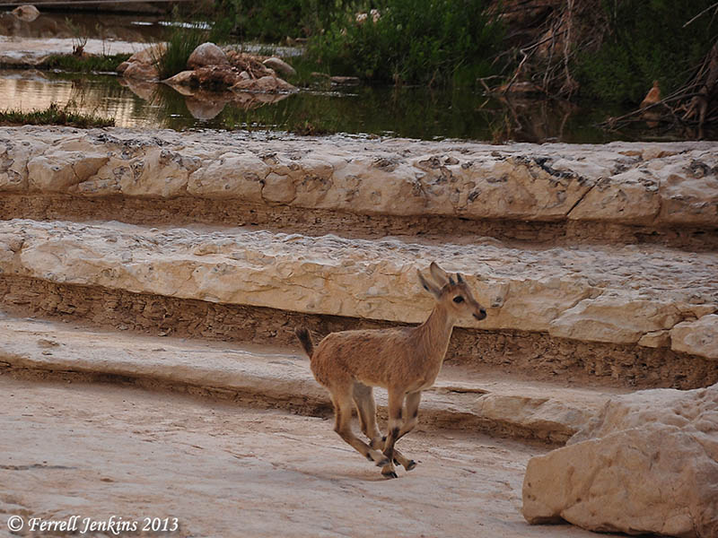
The Ibex may also be seen at En (Ein) Avdat (Avedat) and Mitzpe Ramon in Israel. The photo below shows one of the young Ibex on the run at En Avdat

Young Ibex on the run at En Avdat. Photo by Ferrell Jenkins.

Young Ibex on the run at En Avdat. Photo by Ferrell Jenkins.

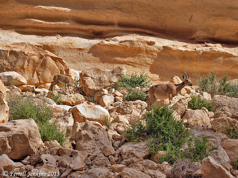
The next photo illustrates how well the Ibex blend in with the terrain in which they live.

Ibex at Avdat in the Wilderness of Zin. Photo by Ferrell Jenkins.

Ibex at En Avdat in the Wilderness of Zin. Photo by Ferrell Jenkins.

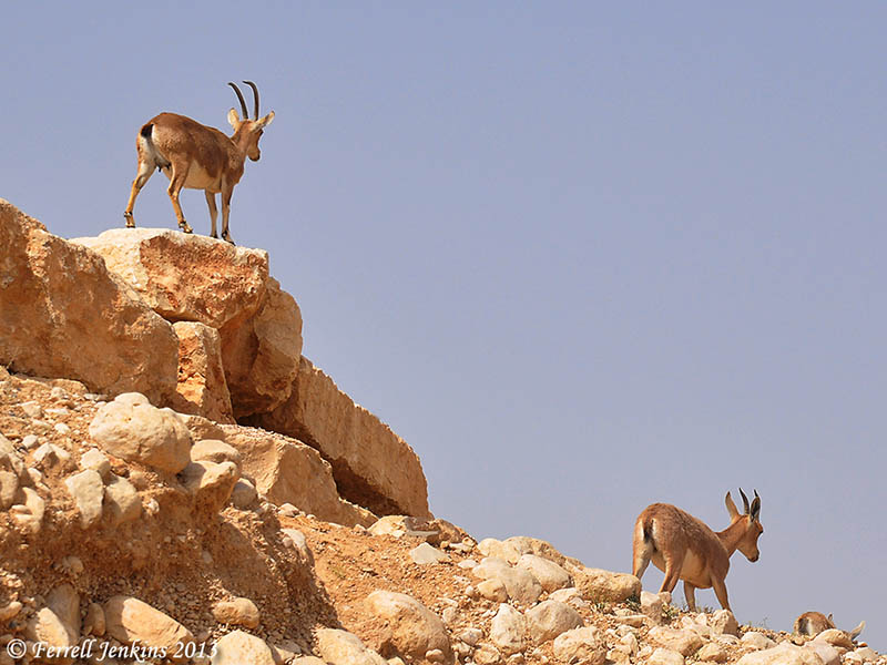
The last photo shows the sure-footed Ibex seeking out the high places.

Ibex in the wilderness of Zin near En Avdat. Photo by Ferrell Jenkins.

Ibex in the wilderness of Zin near En Avdat. Photo by Ferrell Jenkins.

The reference to the hind or deer (Hebrew ayyalah) in Psalm 18:33 (Hebrew 18:34) indicates a different species, but the analogy is the same. Both Hebrew terms are used in Job 39;1.

He makes my feet like hinds’ feet, And sets me upon my high places. (Psalm 18:33 NAU)

He gives me the agility of a deer; he enables me to negotiate the rugged terrain. (Psalm 18:33 NET)

If you would like to see another photo of the Ibex at En Gedi, click here.

Personal Note: A few friends who have missed the blog have contacted me to see if I had returned home and was doing o.k. The answer is yes, and yes. After being away for three weeks I needed some time to recoup, tend to personal matters, and get my photos organized. The subscription price remains the same. Thanks for your concern.

Rivers in the Desert – Wadi Zin

Rivers in the Desert is the title of Nelson Glueck’s 1959 history of the Negev. These rivers also may be seen in the Judean wilderness and in the Sinai. Thomas Levy followed up on some of Glueck’s research in a Biblical Archaeology Review article in 1990.

If one travels in the desert during the summer months he will see a dry, desolate bad land with only an isolated tamarisk tree or shrub where the last water of the winter rain flowed. In the winter it can be different. Israel has two dominant seasons: winter and summer. The summer is dry and the winter is wet. The early rains begin about mid-October and continue till the late rains of early April. See Deuteronomy 11:14 and Joel 2:23.

Levy reminds us that “Nahal, incidentally, is Hebrew for a dry river bed or valley that flows at most a few times a year. In Arabic, the word is wadi. The two words are used interchangeably in Israel today.” The wadi is similar to the arroyo of the American southwest.

While traveling south of Beersheba, yesterday and today, we crossed the Wadi Zin (Joshua 13:21ff.) at least three times in each direction we traveled.

Here is what the Wadi looks like when it is dry.

Wadi Zin near Avedat in the Negev of Israel. Photo by Ferrell Jenkins.

Wadi Zin near Avedat in the Negev of Israel. Photo by Ferrell Jenkins.

And this marker on the highway shows travelers the depth of the water when the wadi is flooded. The person in the photo is six feet tall. The marker goes to 1.5 meters (about 5 feet), and the pole is higher.

Marker to let travelers know the depth of the water in the Wadi Zin.

Marker to let travelers know the depth of the water in the Wadi Zin. Photo by Dan Kingsley.

For more pictures, including rivers in the desert during the rain season, see here.

Meet the Camel Family at Abel-meholah

This morning we drove south from Tiberias through the Jordan Valley. At Abel-meholah, possibly the home of Elisha the prophet (1 Kings 19:16), we saw about a dozen or more camels on the hillside. I was impressed with this group of seven that stayed together apart from the others.

Camels at Meholah in the Jordan Valley. Photo by Ferrell Jenkins.

Camels at Abel-meholah in the Jordan Valley. Photo by Ferrell Jenkins.

Camels are first mentioned in the Bible in the time of Abraham (Genesis 12:16).

Tonight we are at Mitzpe Ramon, a little town that overlooks the Maktesh Ramon. This Maktesh, the largest on the face of the earth, is located about 50 miles south of Beersheba in the Negev wilderness of Israel.

Here and there in Lower Galilee

This morning we set out from Tiberias to reach Khirbet Kana, the likely site of the Cana of Galilee mentioned in John 2. The site along the highway from Nazareth to Tiberias that many tourists visit is the traditional site known as Kafr Kana. Jesus attended a marriage at Cana of Galilee (John 2:1-11), and met the royal official (John 4:46-54).

Traveling as we are, and being extremely tired at night, I have neither the materials or the inclination to go into detail about the matter. Here is a view of the rocky hill located on the north side of the Bet Netofa Valley. The ancient road ran in the valley below the city.

View of Khirbet Kana from the SE. Photo by Ferrell Jenkins.

View of Khirbet Kana from the SE. Photo by Ferrell Jenkins.

This is not the sort of visit one may take lightly. It probably took us 45 minutes in from the main road, and 45 minutes out. (We should have had a Jeep-type vehicle. We spent about an hour walking up one side of the hill and down another. (I hope no one will ask directions!).

Later we made a short stop at Hannathon (Joshua 19:41), and then through Nazareth and Megiddo Junction to see again the Rolling Stone tomb on the south side of the Jezreel Valley. This tomb can no longer be photographed easily by tourists in a bus. There is no room for the bus to stop. Our little car could pull off the road, and we could get close enough to avoid the new railing that has been installed. This is what it looks like and how close the cars, buses, and trucks, come to it.

Rolling Stone tomb near Jezreel Valley. Photo by Ferrell Jenkins.

Rolling Stone tomb near Jezreel Valley. Photo by Ferrell Jenkins.

We were able to get photos similar to the one you see here.

Another brief stop allowed us to take a photo of Tell Jokneam (Joshua 12:22; 19:11; 21:34). On the way back to our home at the Ron Beach Hotel in Tiberias we visited the possible site of En Dor (En-Dor; 1 Samuel 28:7), where Saul visited the medium of En Dor. Our last stop was at the modern town of En Dor where we visited the En Dor Archaeology Museum. It is a great little museum. More about it later.

North of the Sea of Galilee

Most of our visits today were north of the Sea of Galilee. Here are some of the stop we made.

The fishing port of Tiberias, where we saw fishermen bringing in some large fish. One of the owners of the Ron Beach Hotel told us these large fish were used for fish oil.

Hazor.

Senir (Hasbani) River. One of the sources of the Jordan.

Dan. To photograph the Middle Bronze city gate (19th-18th century B.C.).

Beit Ussishkin Museum at Dan. The museum is mostly about the flora and fauna of the region, but there are a few pieces from the Dan excavations.

Hermon Stream Nature Reserve (or Banias River). To see the waterfall.

Omrit. Site of possible Herodian temple to Augustus. The road is horrible, and there is still a long walk to visit the site. It is really not prepared or intended for the casual visitor. Someday it should be.

Abel-beth-maacah (or Abel of Beth-maacah). A city called “a mother in Israel” (2 Samuel 20:19). We had a view of Mount Hermon with a small amount of snow still on the top.

Abel-beth-maacah and Mount Hermon. View toward east. Photo by Ferrell Jenkins.

Abel-beth-maacah and Mount Hermon. View toward east. Photo by Ferrell Jenkins.

Metula. This Israeli town is on the border with Lebanon. We looked over into Lebanon.

Hula Lake/Agamon Lake. This is the restoration of a portion of Hula Lake that had been drained in the mid-20th century. Birds from Asia and Europe travel through the Great Rift and their way to Africa and back. This lake is a favorite stopping place for many of them.

It was a hot day, but an enjoyable one.