Category Archives: Archaeology

Hazor, Dan, Caesarea Philippi, Golan Heights

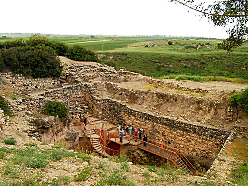
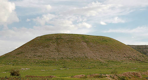
Today we visited sites north of the Sea of Galilee. We began at Hazor, a site overlooking the Hulah Valley. The Israelites came to this large city and defeated the inhabitants and burned the city.

However, Israel did not burn any cities that stood on their mounds, except Hazor alone, which Joshua burned. (Joshua 11:13)

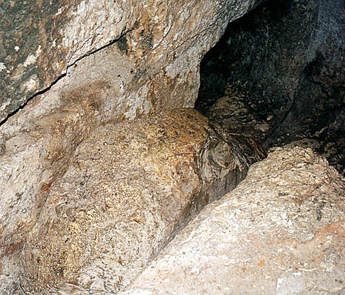
This photo shows the water shaft due in the days of King Ahab of Israel. Gates and walls were for protection, and food and water were a necessity for survival.

The water shaft at Hazor. Photo by

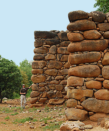
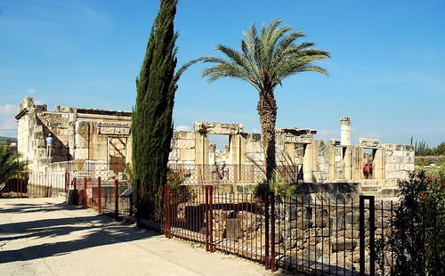
We continued north to the Israeli-Lebanese border at Metulla. Afterwards we went to Tel Dan. In order to get to the tel it is necessary to walk through a nature park, much of it along the Dan River, the strongest source of the Jordan River. Here is a photo of a stretch of reconstructed wall near the city gate.

Reconstruction of the City Wall at Tel Dan. Photo by Ferrell Jenkins.

We continued a short distance east to Banias, the biblical Caesarea Philippi, where Jesus made His promise to build the church upon His own deity.

Now when Jesus came into the district of Caesarea Philippi, He was asking His disciples, “Who do people say that the Son of Man is?” And they said, “Some say John the Baptist; and others, Elijah; but still others, Jeremiah, or one of the prophets.” He said to them, “But who do you say that I am?” Simon Peter answered, “You are the Christ, the Son of the living God.” And Jesus said to him, “Blessed are you, Simon Barjona, because flesh and blood did not reveal this to you, but My Father who is in heaven. “I also say to you that you are Peter, and upon this rock I will build My church; and the gates of Hades will not overpower it. “I will give you the keys of the kingdom of heaven; and whatever you bind on earth shall have been bound in heaven, and whatever you loose on earth shall have been loosed in heaven.” (Matthew 16:13-19)

We made a short stop at Birket Ram, a lake in an extinct crater below Mount Hermon. There was almost no snow on the mountain today. Often a small amount of snow can still be seen by this time of year. We continued to Tiberias through the Golan Heights (biblical Bashan), where one of the cities of refuge was located (Joshus 20:8).

We closed the tour day with a short visit to Mount Arbel for a view of the Sea of Galilee.

The Shabat (Sabbath) has begun in Israel. Jews pour into the hotels for the Shabat to have their meal prepared for them by someone else. We are near a pedestrian street with a number of restaurants. The music is loud, indicating very little in the way of a spiritual significance to the Sabbath. A far cry from the commands of the Torah.

A day in Galilee

is is the way I began the day by viewing the sunrise over the Sea of Galilee from my hotel window at Tiberias. This is always a beautiful view. It brings to mind many of the teaching of Jesus in the Galilee area. Jesus met his disciples on the shores of Galilee after His resurrection. John 21:12 records that Jesus prepared breakfast for the disciples.

Sunrise on the Sea of Galilee. Photo made from Tiberias by Ferrell Jenkins. April 3, 2008.

We always include a boat ride on the Sea of Galilee as part of ou tour. One of the men on our boat showed how nets were cast in bible times. This was in the area where Jesus appeared to the disciples. Here is the account in the Gospel of John:

But when the day was now breaking, Jesus stood on the beach; yet the disciples did not know that it was Jesus. 5 So Jesus said to them, “Children, you do not have any fish, do you?” They answered Him, “No.” 6 And He said to them, “Cast the net on the right-hand side of the boat and you will find a catch.” So they cast, and then they were not able to haul it in because of the great number of fish. (John 21:4-6).


Fisherman casting a net on the Sea of Galilee. Photo by Ferrell Jenkins.

We visited Capernaum, Tabgha, the Mount of Beatitudes, and Bethsaida. We drove along the eastern side of th Sea of Galilee and saw the area where the swine ran down the steep cliff into the sea.(Matthew 8:32). We stopped at En Gev and made a photo of the tell of Hippos. We made a few photos at the new excavations at Tiberias. In December excavations were renewed at Magdala. We stopped at the site, but the entire area is locked and it was practically impossible to make any decent photos of the site due to the fencing around the site. Perhaps in future years the site will be open to the public. Magdala was the home of Mary Magdalene.

Everyone in the group seems to be having a good time learning more about the land of Jesus.

Two of our ladies are publishing blogs that are very informative and are filled with human interest. We learned that the 3rd grade class at Athens Bible School is following our tour as one of their projects. There are four women on our tour who are grandmothers of children in the class. Here are the links to the other blogs.

gowithjo.blogspot.com

The Corinth Canal

The city of Corinth is located about two miles south of the narrow isthmus which forms the land bridge, and controlled access, between the main land mass of Greece and the Peloponnesus.

The isthmus is less than five miles wide. In ancient times small ships were dragged across the isthmus on a paved road called the diolkos. Small portions of the diolkos may still be seen. Larger ships unloaded their cargo which was carried across and reloaded. This avoided the long 200 mile journey around the Peloponnesus. Nero abandoned his attempts to dig a canal across the isthmus (A. D. 67).

A canal was constructed between 1881 and 1893. Here is a photo of that canal with a tug boat pulling a ship through the canal.

Corinth Canal. Photo by Ferrell Jenkins.

The apostle Paul likely came to Corinth about A.D. 51, during the reign of the Roman Emperor Claudius, and remained there for eighteen months (Acts 18). The book of Acts records the success of that work:

Crispus, the leader of the synagogue, believed in the Lord with all his household, and many of the Corinthians when they heard were believing and being baptized. (Acts 18:8).

Archaeological excavations have been conducted at the ancient city of Corinth since 1896 by the American School of Classical Studies in Athens.

Honoring Dr. Jack P. Lewis

Dr. Jack P. Lewis was honored March 6 at a dinner hosted by Faulkner University, Montgomery, Alabama, during their annual Bible lectureship. I was pleased that I could attend the lectures one day and be present for the dinner honoring Dr. Lewis.

Lewis is Professor Emeritus at the Harding Graduate School of Religion in Memphis. Among several good teachers that I had, Lewis was unique. He holds two earned doctorates, a Ph.D. in New Testament from Harvard, and a Ph.D. in Old Testament from Hebrew Union. He was the most demanding teacher I had, and one of a few from whom I learned the most.

After the high school years at Athens Bible School, and four years of Bible at Florida Christian College (now Florida College), with teachers such as Homer Hailey, I had a good general knowledge of the Bible. I think I had about 60 hours of Bible at FCC. The graduate work was not too difficult, it was just on a higher level.

It was part of the graduate program generally, but Lewis taught the importance of using primary sources where possible and the importance of thorough preparation. He entered the class room, called the roll, and began lecturing. As a student I made notes the best I could, then spent hours after each class verifying the names, dates, and facts presented. Different from the students I had in college, we would never imagine asking “How do you spell that?” He taught us the importance of using up-to-date sources in our research.

Jack Lewis was my first teacher who had spent a considerable amount of time studying the land of the Bible. He had worked in the archaeological excavation at Arad, and had spent a year as a fellow at the American Schools of Oriental Research in Jerusalem (now the Albright Institute).

In one of the classes with Dr. Lewis I did a paper on “Authentic First Century Remains in Palestine.” Soon afterward I began to prepare for my own visit to the Bible lands. I might have gone anyway, but I must credit Dr. Lewis, and his unique insight into the land of the Bible, for spurring my interest in traveling to this part of the world. The other day, as we visited, he said something like this: “There is nothing as valuable as seeing the places you study about.” So, now you know one of the major motivations in my travels to Bible lands over all these years since the first trip in 1967. I still learn on every trip, and in the preparation for the trip.

Dr. Lewis is a prolific writer. His many books included The History of the English Bible from the KJV to the NIV, The Interpretation of Noah and the Flood in Jewish and Christian Literature, Historical Backgrounds to Bible People, a two volume commentary on the Gospel of Matthew. There are also books on the prophets and other areas of biblical studies.

Several Faulkner faculty members spoke of what Lewis had meant to them. These included Dr. Cecil May, Jr., Dr. Carl Cheatham, and Dr. Ed Hicks. Dr. Jim Howard, from Memphis, was also on the program. Carl and Jim were at HGSR when I was there. Cecil and I spoke on the same topic at both the Nashville and Dallas meetings of institutional and non-institutional brethren a few years back. It was a pleasure to see them.

In the afternoon, Dr. Lewis had presented a lecture on “The Battle for the Integrity of the Bible.” In his typical rapid-fire manner, he surveyed the battles that have been won in demonstrating the integrity of the Bible. It was just a survey, but he seemed as sharp as in those classes on The History of the English Bible and on Archaeology and the Bible from which I profited so much.

Today Dr. Jack Pearl Lewis is 89 years old. Happy birthday, Dr. Lewis.

Dr. Jack P. Lewis and Ferrell Jenkins. Photo by Leon Mauldin.

This photo was made March 6 after the lecture on “The Battle for the Integrity of the Bible.”

The Home of Elisha

Abel Meholah (or Abel-meholah), NAS, ESV is a tell in the Jordan Valley, about 10 miles south of Beth-shean. It is mentioned only three times in the Bible. The Midianites, who were fleeing from Gideon’s army of 300, fled as far as the border of Abel Meholah (Judges 7:22).

Solomon (reigned 970-931 B.C.) set up administrative officers over Israel. Baana, the son of Ahilud, was over the fifth district that included Abel Meholah.

Baana the son of Ahilud, in Taanach, Megiddo, and all Beth-shean that is beside Zarethan below Jezreel, and from Beth-shean to Abel-meholah, as far as the other side of Jokmeam (1 Kings 4:12, ESV).

Many of us likely would find Abel Meholah of interest as the home of Elisha the prophet. When Elijah met the LORD at Horeb, the mountain of God, he was told to do three things: (1) Anoint Hazael king over Aram [Syria]; (2) Anoint Jehu king over Israel; (3) Anoint Elisha from Abel Meholah to take his place as prophet. This took place around the middle of the 9th century B.C. See 1 Kings 19:11-16.

Elijah and Elisha were two of the more important oral prophets of Israel. Elijah was among the settlers of Gilead, on the east side of the Jordan (1 Kings 17:1).

The identification of Abel Meholah is uncertain. Two sites east of the Jordan River have been suggested. The biblical statements seem to favor a site on the west side of the Jordan. Four sites have been suggested. Check the Anchor Bible Dictionary for details and a bibliography. Our photo is of Tell Abu Sus. Future excavations may help settle this question. This is a beautiful example of a tell. Who knows what might be buried within it?

Abel Meholah in the Jordan Valley. Possible home of the prophet Elisha. Photo by Ferrell Jenkins.

A Day in Capernaum

I just ran across the third edition of A Day in Capernum by Franz Delitzsch. Yes, the Delitzsch of the famous Keil and Delitzsch 19th century commentaries on the Old Testament. The book was written in 1870, but the third edition was published in 1892. In the days before motorized vehicles, visitors had to travel by foot or horseback. This had a distinct value in allowing more time to meditate and understand the importance of the travel routes, etc. The writer visits some of the other places around the Sea of Galilee and tells how long it took to move from one place to another.

Works of this kind are of value because they reflect the scholarship and understanding of the time. You may read the work online, or download it in PDF from Google Book Search. Here is the directly link to A Day in Capernaum.

Google Book Search is a wonderful place to find many older works in their entirety. Some pages of many newer works are also availalbe.

Things have changed a lot at Capernaum since Delitzsch was there. We believe the foundation of the synagogue from the time of Jesus is known. The synagogue from the late 4th or early 5th century A.D. has been partially reconstructed mainly by the late archaeologist Stanislao Loffreda. The photo shows how it looks today.

Reconstructed Capernaum synagogue from 4th or 5th century A.D. Photo by Ferrell Jenkins.

The most important thing about Capernaum is that Jesus came and settled in the city and that it was the scene of much of His ministry and miracles (Matthew 4:13; 11:23).

Gath or Not Gath?

There is some discussion over at the Tel es-Safi/Gath site about the correct identification of the photo from 1969 which I identified as Gath here.

Based on my recollection of the location of the tel, I think those who have identified it as Tel Erani are correct. Here is a comment I have left on the Tel es-Safi/Gath page.

Sorry to be the center of a controversy. I think this photo was made very near Qiryat Gat. I have only been in this area a few times and was having a hard time identifying this tel with the photos of Tell es-Safi. Todd is probably correct in saying this was still the identification given by a guide back in 1969.
I am away from home for a couple of days but what I have been able to locate on the Internet indicates that the photo is of Tel Erani.
My recollection is that this tel is on the north side of the road leading from Bet Guvrin and Lachish to Ashkelon.

My plans are to be back in Israel in a month, but I won’t have the opportunity to check these places. Maybe later in the year!

The Tell es-Safi/Gath Archaeological Project

Prof. Aren Maeir, director of the Tell es-Safi/Gath Archaeological Project, asked permission to post my 1969 photo of the tell which we posted here. I was honored to do so. He has given us some directional info that I overlooked. He says that it is “of the northeastern portion” of the tell. He comments on the changes that have taken place since 1969.

Not only is the foto very nice, it is very interesting, since there are quite a few changes that can be seen on the tell since then. In particular, the intense 4X4 vehicle activity has taken a toll on the site, and a current view shows various parts that have been eroded away.

Maeir’s post includes a recent photo showing the northeastern part of the tell from another angle. Take a look here.

Back in 2005, I think, a pottery shard, inscribed with the Semitic letters AWLT and WLT, was found. Maeir says,

BOTH names that appear on the sherd (AWLT and WLT…) are etymologically very close to Goliath. All are quite similar to Indo-European, names such as Lydian Wylattes/Aylattes, which in the past have been etymologically compared to Goliath (way before this find).

I can’t resist posting a tiny photo here.

Goliath Inscription on Pottery from Tell es-Safi/Gath.

There is a wonderful high resolution photo of the shard online with other information. Read here.

The excavation at Tell es-Safi/Gath this year will be July 6-August 1. Click here for some information about the dig if you have interest. This site, near the valley of Elah, provides a wonderful background for the conflict between the Philistines and the Israelites, between David and Goliath.

Then a champion came out from the armies of the Philistines named Goliath, from Gath, whose height was six cubits and a span. (1 Samuel 17:4)

The Queen of Adiabene and a Rolling Stone

Queen Mother Helena of Adiabene came to Jerusalem with her son, King Izates, as a convert to Judaish in A.D. 46. Adiabene was located in northern Mesopotamia east of the Tigris River. During the famine in Judea, mentioned in Acts 11:28-30, the queen sent to Egypt for grain and to Cyprus for dried figs (Josephus, Ant. 20.51).

A recent excavation south of the Dung Gate, called the Givati garage area, has revealed a massive building which is being suggested as the palace of Queen Helena. So far there is no absolute proof that the Queen is to be identified with the structures, but it is a good suggestion. The reference in Josephus to the palace of the Queen in the lower city is helpful (Jewish Wars 6.355).

The press release of the Israel Antiquities Authority, December 3, 2007, says:

In the excavations the Israel Antiquities Authority is carrying out with the Nature and Parks Authority and the Ir David Foundation, an impressive architectural complex is being uncovered that includes massive foundations; walls, some of which are preserved to a height in excess of five meters and built of stones that weigh hundreds of kilograms; halls that are preserved to a height of at least two stories; a basement level that was covered with vaults; remains of polychrome frescoes; water installations and ritual baths (miqve’ot).

This photo shows the excavation at the bottom and the south wall of the old city of Jerusalem at the top. The City of David is directly to the right of the excavation.

Skyview of the excavation thought to be a palace belonging to Queen Adiabene. Photo supplied by the Israel Antiquities Authority.

The photo below shows details of one portion of the excavation.

Excavation thought to be palace of Queen Adiabene. Photo provided by Israel Antiquities Authority.

The excavation turned up stone vessels, pottery, and coins belonging to the end of the Herodian Temple [Israelis call this the Second Temple] period. This means prior to A.D. 70 when the Romans destroyed the temple. These coins bear images of, among other things, a vine leaf, a chalice, and an amphora with handles.

Coins found in the Givati excavation. Photo supplied by the Israel Antiquities Authority.

A large burial complex was dug north of the city for the burial of the Queen and her family. This is the tomb referred to in modern times as the Tomb of the Kings. It is a good place to see a rolling stone and a tomb hewn from solid rock. The property is under French control and the last three or more times I have been there it has been closed, and I was unable to rouse anyone by ringing the bell.

Tomb of the Kings, Jerusalem. The tomb of Queen Adiabene. Photo by Ferrell Jenkins.
This rolling stone is of the same type that covered the tomb of Jesus. When Joseph of Arimathea was granted permission from Pilate to bury Jesus, the historical record says,
And Joseph took the body and wrapped it in a clean linen cloth, and laid it in his own new tomb, which he had hewn out in the rock; and he rolled a large stone against the entrance of the tomb and went away. (Matthew 27:59-60)

Logos has ANET on pre-pub

Logos is the premier source for good books available for use on the computer. Now they have Ancient Near Eastern Texts, edited by James Pritchard, on pre-pub. When Logos puts a book on the pre-pub list it means that they offer it for a lower price to those who will agree to buy it when it is ready for distribution. Over the years I have secured several good works this way.

Take a look at the pre-publication special information. The price will be $59.95. I have signed up, and I hope that you will do the same. Amazon offers the print version for $115.00.

Pritchard, Ancient Near Eastern Texts.

Everyone who studies the Bible and the historical association with countries like Egypt, Assyria, Babylon, and Persia, needs this work. The print edition costs about twice as much as the Logos digital version. The ability to search the Logos version will be a distinct advantage.

This edition of 735 pages was first published in 1969. Cyril J. Barber, The Minister’s Library, describes the original publication in these words:

Popularly referred to as ANET. An indispensable aid in understanding the background and culture of the peoples in the Ancient Near East.

HT: BiblePlaces Blog